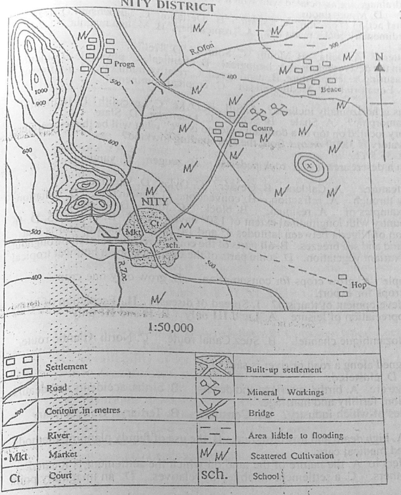
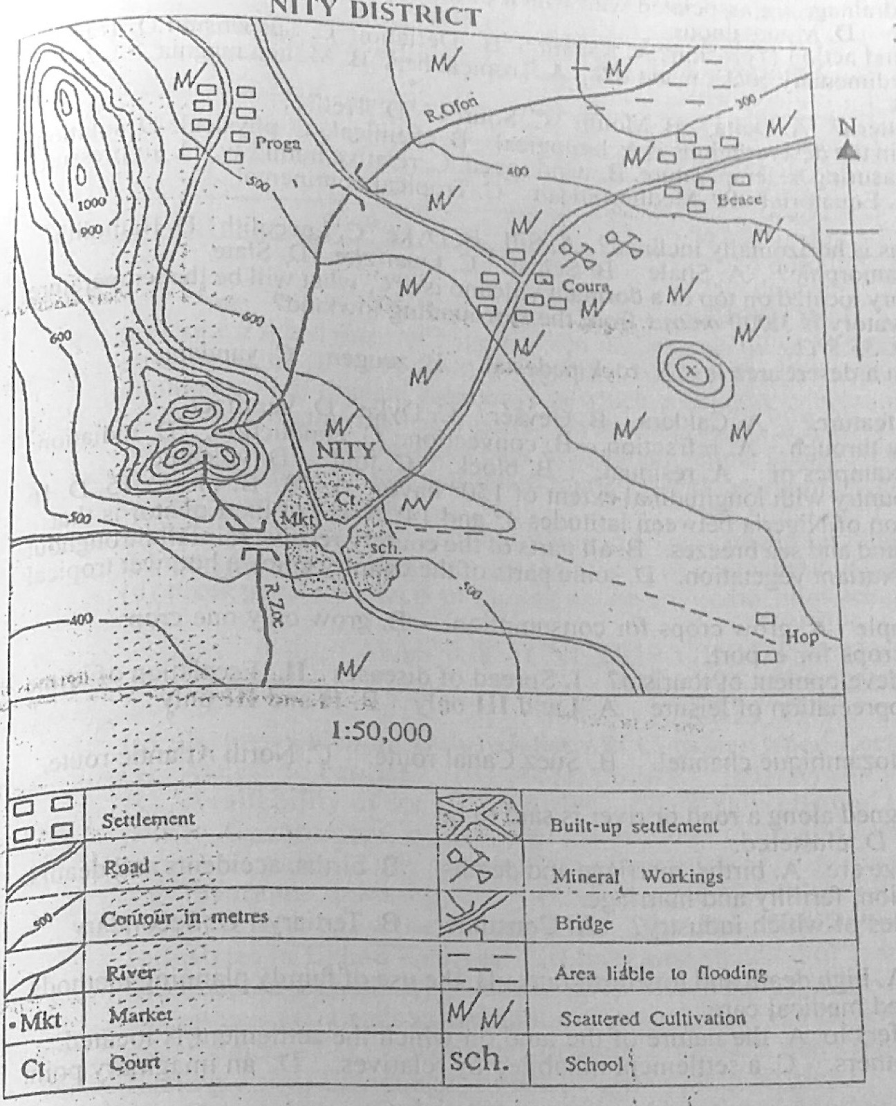
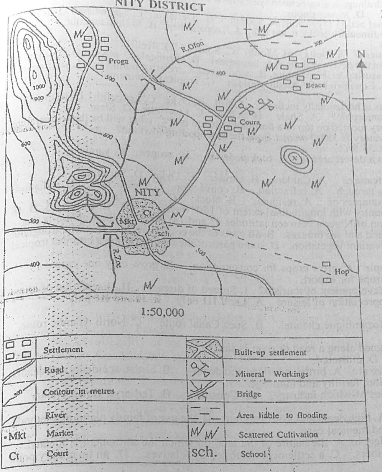
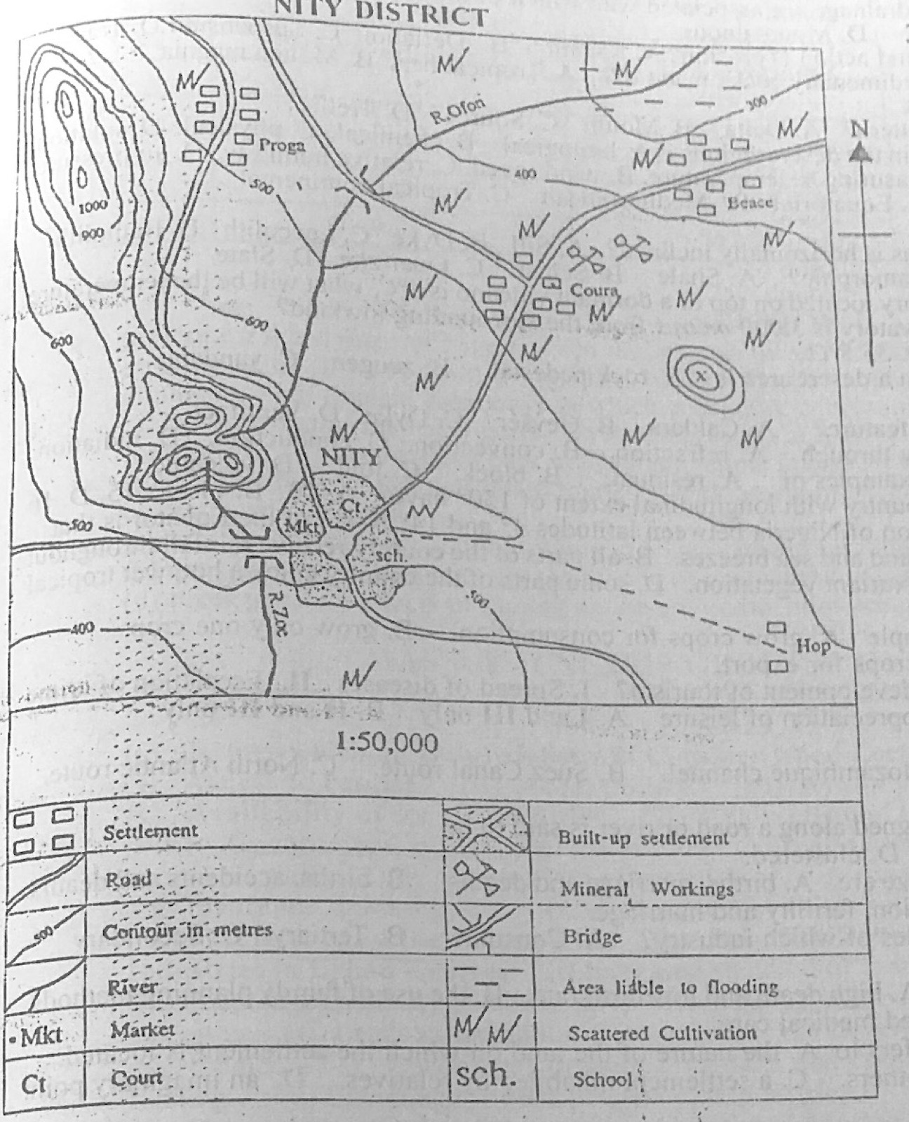
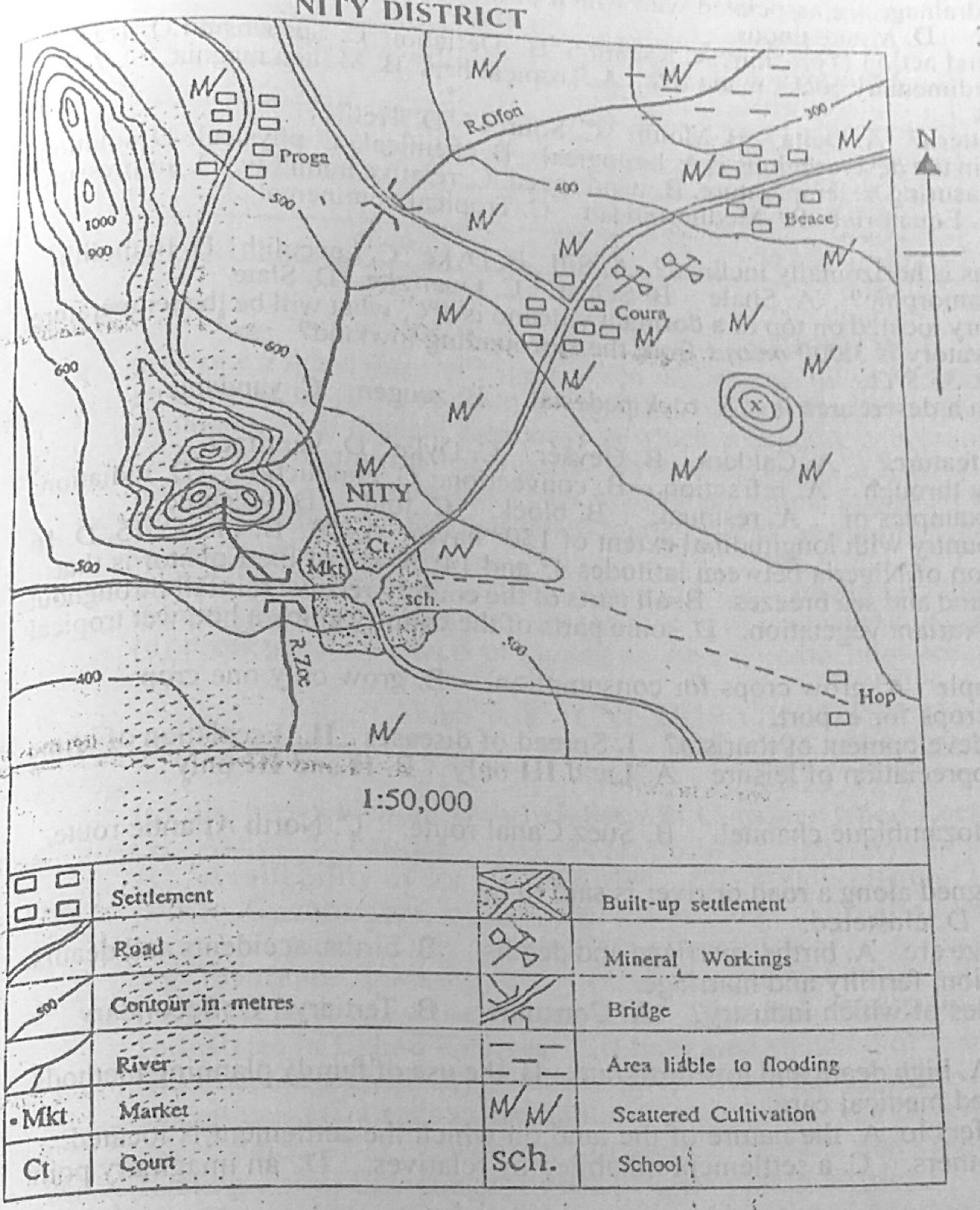
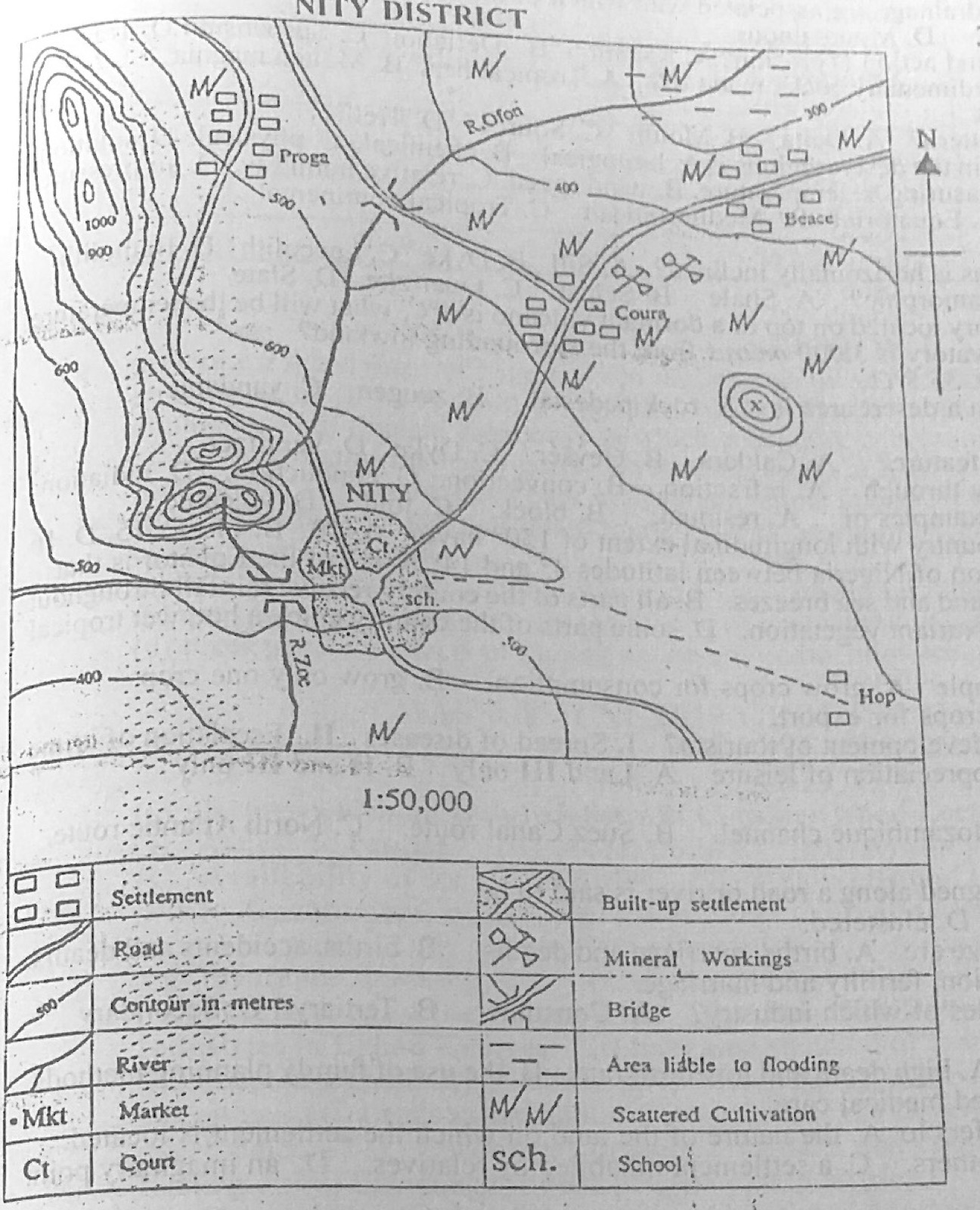
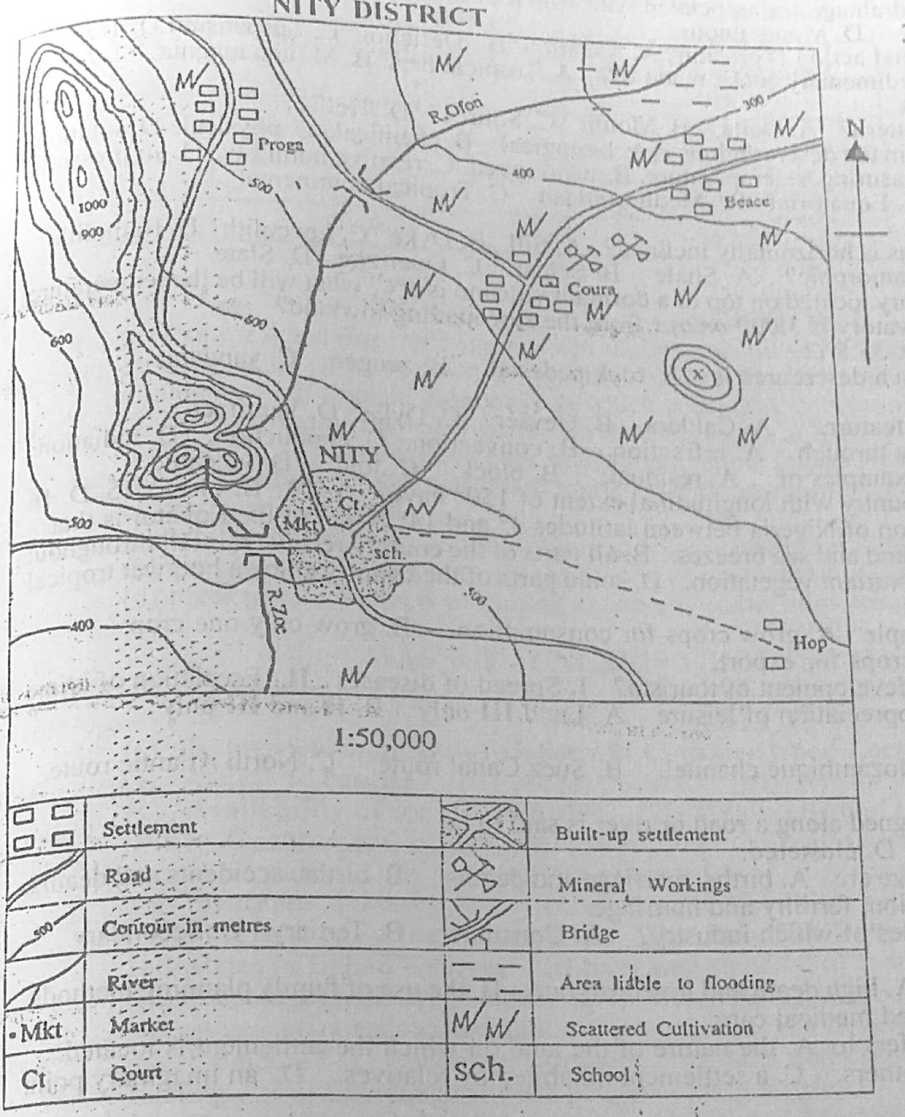
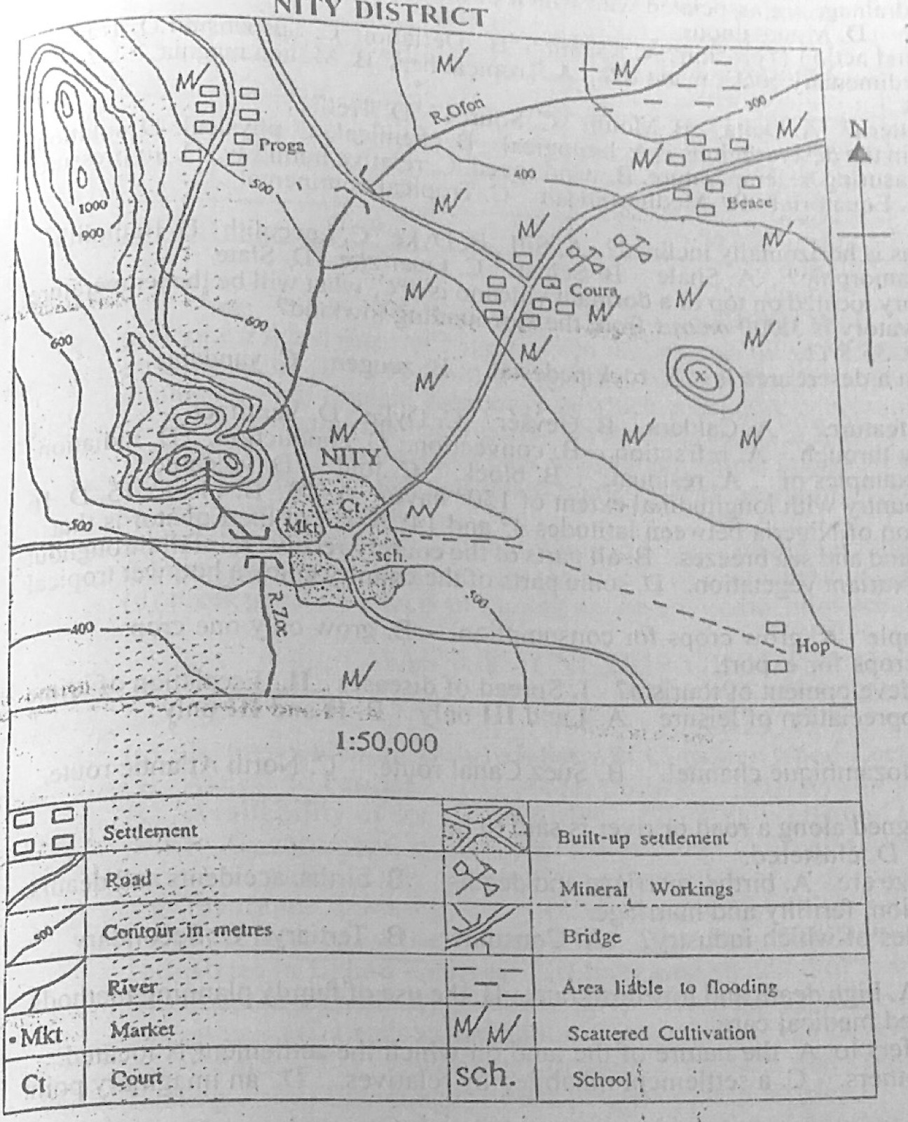
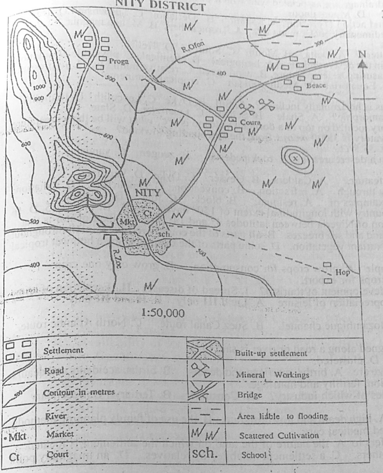
Study the map of NITY DISTRICT (scale 1:50,000) to answer this question. If the map of NITY DISTRICT is reduced to half, what will be the scale of the new map in Representative Fraction (RF)?
A.1 : 25,000
B.1 : 50,000
C.1 :100,000
D.1 : 150,000
Show the answer and explanation
Answer: C (1 :100,000)
Explanation
Halving the map's size doubles the denominator: 1:50,000 becomes 1:100,000.
Study the map of NITY DISTRICT (scale 1:50,000) to answer this question. The relief feature on the west of NITY which extends to the north-western corner of the map is a
A.gorge.
B.plain.
C.plateau.
D.ridge.
Show the answer and explanation
Answer: D (ridge.)
Explanation
A long narrow belt of high land with closely spaced contours: a ridge.
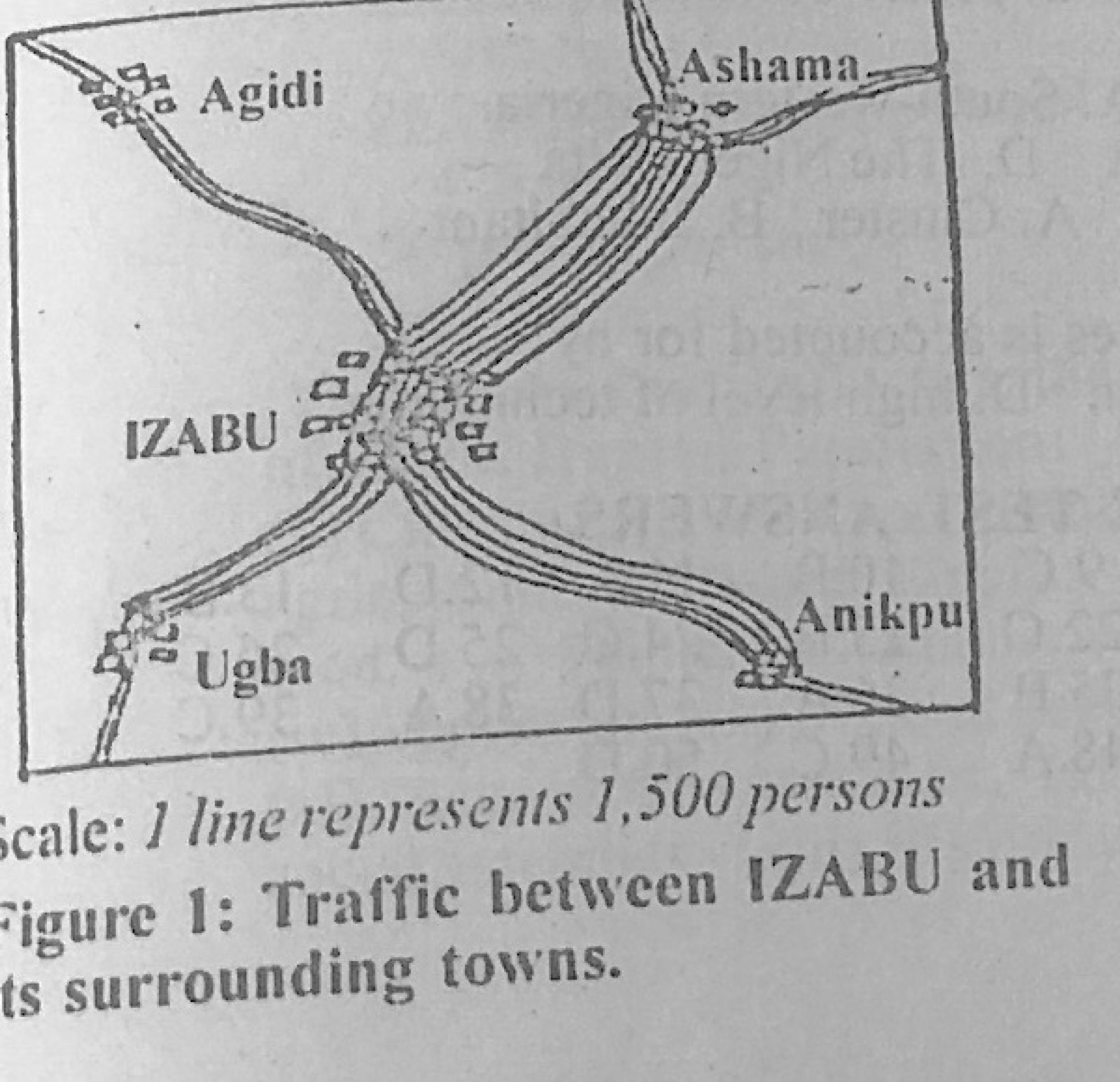
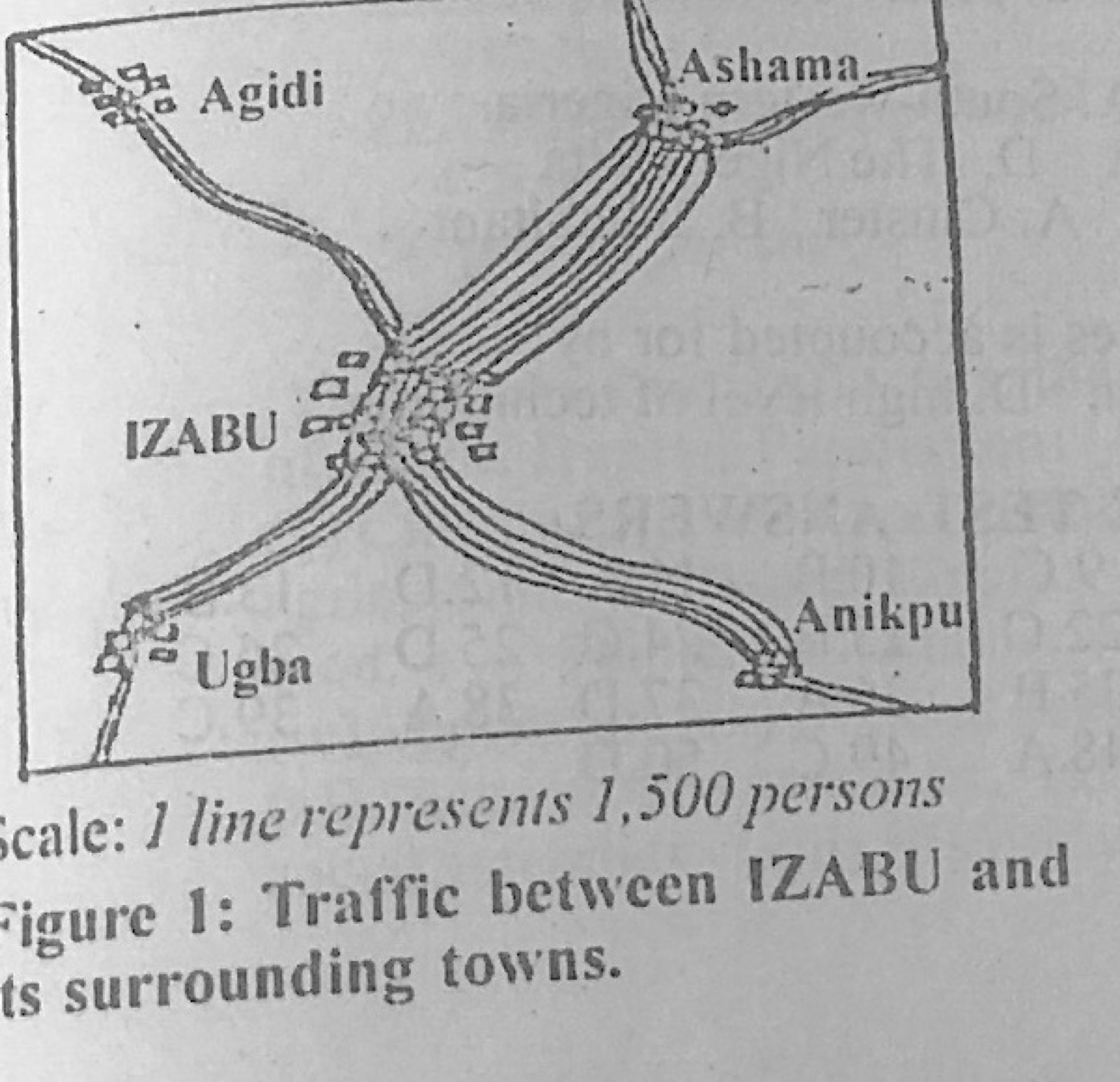
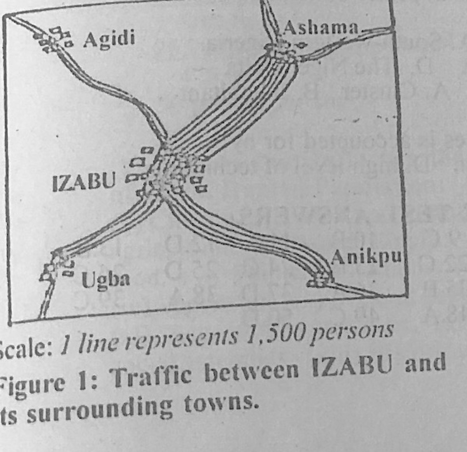
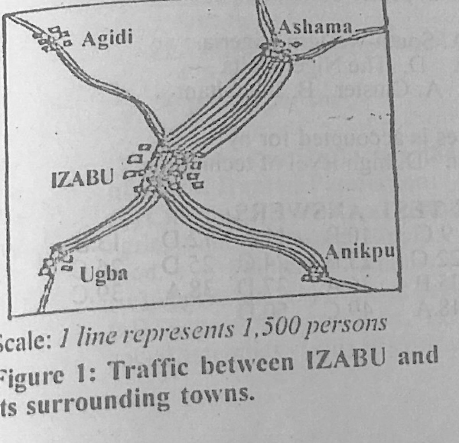
Figure 1 shows the volume and direction of passenger traffic between IZABU town and its surrounding towns in the year 2001 (scale: 1 line represents 1,500 persons). Use it to answer this question. Which of the following statistical methods is represented above?
A.Dot map
B.Isohaline map
C.Flow map
D.Barchart
Show the answer and explanation
Answer: C (Flow map)
Explanation
Bands of lines between towns, whose width shows the volume of movement, form a flow map.
Figure 1 shows the volume and direction of passenger traffic between IZABU town and its surrounding towns in the year 2001 (scale: 1 line represents 1,500 persons). Use it to answer this question. How many passengers travelled between IZABU and Ashama?
A.6,000
B.8,000
C.10,000
D.12,000
Show the answer and explanation
Answer: D (12,000)
Explanation
The IZABU-Ashama band has 8 lines: 8 × 1,500 = 12,000.
Figure 1 shows the volume and direction of passenger traffic between IZABU town and its surrounding towns in the year 2001 (scale: 1 line represents 1,500 persons). Use it to answer this question. By how much is the traffic between IZABU and Anikpu more than the traffic between IZABU and Ugba?
A.1,200
B.1,500
C.1,700
D.1,800
Show the answer and explanation
Answer: B (1,500)
Explanation
The Anikpu band has one more line than the Ugba band: 1 × 1,500 = 1,500.
Figure 1 shows the volume and direction of passenger traffic between IZABU town and its surrounding towns in the year 2001 (scale: 1 line represents 1,500 persons). Use it to answer this question. One major advantage of the figure is that, it
A.is easy to construct.
B.shows quantity and direction together.
C.is easy to interpret.
D.involves mathematical calculation.
Show the answer and explanation
Answer: B (shows quantity and direction together.)
Explanation
A flow map shows both how many people move and where they move to.
If the temperature reading at an observatory located on top of a dormant volcano is 6°C, what will be the temperature at the bottom of the volcano if the observatory is 3,000 metres from the surrounding lowland?
A.5.5°C
B.13.5°C
C.25.5°C
D.35.5°C
Show the answer and explanation
Answer: C (25.5°C)
Explanation
Temperature rises 6.5°C per 1,000 m going down: 3 × 6.5 = 19.5°C, so 6 + 19.5 = 25.5°C.
Which of the following factors hinder the development of tourism? I. Spread of diseases II. Escalation of crime III. Adequate publicity IV. Inadequate appreciation of leisure
A.I and III only
B.II and III only
C.I and IV only
D.III and IV only
Show the answer and explanation
Answer: C (I and IV only)
Explanation
Diseases and poor appreciation of leisure discourage tourism; adequate publicity helps it. Of the pairs offered, only I and IV are both hindrances.
(a) Outline five factors which an industrialist will consider when locating a fruit canning industry. (b) Explain five benefits derived from the concentration of manufacturing industries in urban centres.
Show the model answer
Model answer
(a) Nearness to fruit-growing areas (perishable raw materials); market; transport (good roads); power supply; water supply; labour; capital; government policy (tax holidays); land/site; security and political stability; availability of cans and packaging. (b) Shared infrastructure (power, water, roads) lowers costs; large market close by; ready supply of skilled and unskilled labour; linkages between industries (one uses another's products or by-products); support services (banks, insurance) nearby; more employment and higher living standards; encourages innovation and competition; development of social amenities.
Explanation
Fruits are perishable, so stress nearness to raw materials.
The Table 1 below shows the population distribution and land area of five states of country B in the year 2010. Use the data to answer the following questions. State U: population 3.2 million; land area 140,000 km² State V: 5.4 million; 98,000 km² State W: 7.4 million; 35,000 km² State X: 6.5 million; 120,000 km² State Y: 4.2 million; 86,000 km² (a) Calculate the: (i) total population; (ii) total land area; (iii) population density of country B. (b) Explain four factors that influence the distribution of world human population. (c) Outline three factors that cause increase in world human population.
Show the model answer
Model answer
(a)(i) 3.2 + 5.4 + 7.4 + 6.5 + 4.2 = 26.7 million. (ii) 140,000 + 98,000 + 35,000 + 120,000 + 86,000 = 479,000 km². (iii) 26,700,000 ÷ 479,000 ≈ 56 persons per km². (b) Relief (people prefer lowlands to rugged mountains); climate (moderate rainfall and temperatures attract people, deserts and polar areas repel); soils (fertile soils support dense farming populations); water supply; minerals and industries (jobs); transport and accessibility; political stability and government policy; historical and cultural factors; diseases and pests. (c) Improved medical care lowering death rates; high birth rates; early marriage and polygamy; improved food supply; religious and cultural beliefs favouring large families; illiteracy and poor use of family planning; immigration; improved sanitation and living standards.
Write a geographical account of road transportation under the following headings: (a) three advantages; (b) three disadvantages; (c) four contributions to development.
Show the model answer
Model answer
(a) Flexible (door-to-door service); cheaper to build than railways; can reach remote rural areas; good for short distances and perishable goods; vehicles are easy to acquire and operate; quick loading and unloading. (b) Accidents; traffic congestion; unsuitable for very bulky goods over long distances; high maintenance costs; roads damaged by heavy rain and flooding; pollution; armed robbery. (c) Movement of people and goods; opens up rural areas and links farms to markets; employment (drivers, mechanics, traders); promotes trade; growth of towns along roads; national integration; supports tourism; revenue to government (tolls, licences).
(a) Draw a sketch map of Nigeria. On the map, show and name: (i) one cocoa growing belt; (ii) one groundnut growing belt; (iii) one town in 4(a)(i). (b) Describe three physical conditions necessary for the cultivation of groundnut. (c) Explain four ways in which groundnut cultivation has contributed to the economy of Nigeria.
Show the model answer
Model answer
(a) Map: cocoa belt in the south-west (Ondo, Osun, Oyo, Ogun, Ekiti, Kwara/Kogi parts); groundnut belt in the north (Kano, Katsina, Jigawa, Bauchi, Sokoto); town in the cocoa belt e.g. Ibadan, Akure, Ondo, Ile-Ife, Oshogbo. (b) Warm temperatures (24-30°C); moderate rainfall (500-1,000 mm) with a dry period for harvesting; light, well-drained sandy or loamy soils so the pods can develop underground; long sunny growing season (about 4-5 months); gentle land. (c) Foreign exchange from exports (groundnut pyramids of Kano); raw materials for industries (oil mills, soap, cosmetics, animal feed); employment for farmers and traders; food (oil, kuli-kuli, groundnut paste); revenue to government; growth of towns and transport (railway to Kano); income for farmers.
(a) Draw an outline map of Nigeria. On the map, locate and name: (i) one national park in the north that is important for tourism; (ii) one national park in the south that is important for tourism; (iii) Calabar town. (b) Outline four factors that retard tourism development in Nigeria. (c) Suggest three ways by which tourism can be promoted in Nigeria.
Show the model answer
Model answer
(a) Map: northern park e.g. Yankari (Bauchi), Kainji Lake (Niger/Kwara), Gashaka-Gumti (Taraba/Adamawa), Chad Basin; southern park e.g. Cross River National Park, Old Oyo National Park, Okomu (Edo); Calabar on the coast in the south-east. (b) Insecurity and kidnapping; poor roads and infrastructure; inadequate funding; poor publicity and negative reports; high cost of hotels and services; poorly trained staff and tour guides; political instability; poor maintenance of sites; poaching and deforestation. (c) Improve security; build and maintain roads, hotels and amenities; publicise sites at home and abroad; adequate funding and loans to investors; train staff and guides; enforce laws against poaching; tax incentives; consistent government policy.
Write a geographical account of mining in Nigeria under the following headings: (a) four mineral deposits; (b) one town that is important for the mining of each of the minerals in 6(a); (c) three benefits of mining in Nigeria; (d) three negative effects of mining on the environment of mining areas.
Show the model answer
Model answer
(a) and (b) Coal: Enugu (or Okaba); crude oil: Port Harcourt, Warri, Ughelli, Oloibiri; natural gas: Afam, Bonny; limestone: Ewekoro, Nkalagu, Sokoto, Obajana; tin and columbite: Jos, Bukuru, Barkin Ladi; iron ore: Itakpe; gold: Ilesha; lead and zinc: Abakaliki; lignite: Asaba. (c) Employment; foreign exchange; revenue to government; raw materials for industries; growth of towns and infrastructure; attraction of foreign investment; acquisition of skills and technology. (d) Destruction of farmland and vegetation; soil erosion and mining ponds/pits; pollution of air, water and land (oil spills, gas flaring); loss of soil fertility; displacement of people; health hazards; destruction of the landscape; loss of wildlife.
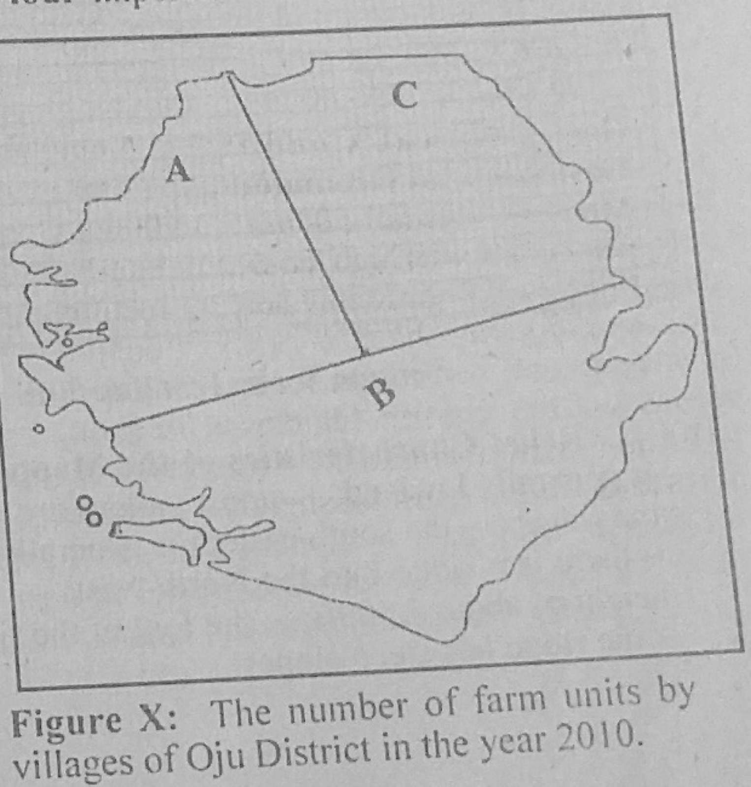
The Table X below shows the number of farm units in three villages of Oju District in the year 2010. Use the data in Table X to answer the questions that follow. Village A: 81 Village B: 100 Village C: 64 (a) Using the map of Oju District provided and a radius of 1 cm to represent 3 farm units, construct proportional circles to represent the data. (b) State two disadvantages of proportional circles.
Show the model answer
Model answer
(a) Square roots: A = √81 = 9; B = √100 = 10; C = √64 = 8. Radii at 1 cm to 3 units: A = 9 ÷ 3 = 3.0 cm; B = 10 ÷ 3 ≈ 3.3 cm; C = 8 ÷ 3 ≈ 2.7 cm. Draw each circle centred in its village area on the map of Oju District, with a key and title. (b) Calculation of square roots takes time; circles may overlap and cover the map; it is hard to compare areas of circles accurately by eye; exact values cannot be read off easily; large circles may not fit small regions.
(a) What is a lake? (b) Describe the formation of lakes by wind erosion. (c) Identify three benefits of lakes to man.
Show the model answer
Model answer
(a) A lake is a large body of water lying in a hollow (depression) on the land surface, surrounded by land. (b) In deserts, strong winds remove loose dry sand and dust (deflation); eddies deepen and widen the depression; deflation continues down to the water table, where moist ground stops further removal; groundwater seeps in, or rain water collects, forming a lake or oasis, e.g. Qattara Depression, lakes in the Kalahari and Sahara. (c) Water for domestic use and irrigation; fishing; transport; HEP (man-made lakes); tourism and recreation; moderation of local climate; source of minerals (salt, trona); habitat for wildlife.
(a) Highlight four characteristics each of the following: (i) Time Zone; (ii) International Dateline. (b) If two towns A and B are located on different time zones and the time in town A is 9.00 am while the time in town B is 6.00 pm the same day, calculate the longitude of town B if the longitude of town A is 30° W.
Show the model answer
Model answer
(a)(i) Time zone: a belt of about 15° of longitude; all places in it use the same standard time; adjacent zones differ by one hour; boundaries follow national or state borders, not exact meridians; there are 24 zones; large countries (USA, Russia) have several. (ii) International Date Line: follows roughly the 180° meridian; it zigzags to avoid land and island groups; crossing it eastward you go back one day, westward you gain a day; it is in the Pacific Ocean; it marks where each new day begins. (b) Time difference = 6.00 pm − 9.00 am = 9 hours; 9 × 15° = 135°; B is ahead, so it lies east of A: −30° + 135° = 105°E. Longitude of B = 105°E.
With the aid of diagrams, describe the mode of formation of the following features: (a) stack; (b) fold mountain.
Show the model answer
Model answer
(a) Stack: waves attack a headland of resistant rock along joints and faults by hydraulic action and abrasion; caves form on both sides of the headland; the caves meet to form an arch; continued wave attack and weathering make the roof of the arch collapse, leaving a pillar of rock standing in the sea: a stack (later worn down to a stump). Diagrams: cave, arch, stack. (b) Fold mountain: sediments accumulate in a geosyncline (sea basin) between two land masses; earth movements push the land masses together (compressional forces, plate convergence); the layers are squeezed and buckled into anticlines and synclines; continued compression produces overfolds, recumbent folds and nappes, raising high fold mountains, e.g. Alps, Himalayas, Atlas, Andes. Diagrams: before and after compression.
(a) With the aid of a labelled diagram, describe the weather instrument used to measure the amount of rainfall. (b) State three precautions which must be taken when using the instrument described in 7(a). (c) Explain how the instrument described in 7(a) is used to obtain total annual rainfall.
Show the model answer
Model answer
(a) Rain gauge: a copper or metal cylinder containing a funnel (about 12-20 cm across) that leads rain into a collecting jar or bottle inside; it is sunk partly into the ground with about 30 cm above the surface; a graduated measuring cylinder is used to read the rain collected in mm. Labelled diagram: funnel, outer cylinder, collecting jar, ground level, measuring cylinder. (b) Place in an open space away from trees and buildings; keep the top about 30 cm above the ground to avoid splashes; sink part of it into the ground to keep it steady and reduce evaporation; read it at the same time every day; keep the funnel clean; protect it from animals. (c) Measure the rain collected every day (24 hours) and record it; add the daily totals to get the monthly totals; add the twelve monthly totals to obtain the total annual rainfall.
(a) Define food chain. (b) Describe the energy flow within a terrestrial ecosystem. (c) Highlight three ways by which nitrogen cycle is maintained in the terrestrial ecosystem.
Show the model answer
Model answer
(a) A food chain is a series of organisms through which food energy passes, each feeding on the one before it, e.g. grass → grasshopper → frog → snake. (b) Energy comes from the sun; green plants (producers) trap it by photosynthesis; herbivores (primary consumers) eat plants; carnivores (secondary and tertiary consumers) eat herbivores; at each level much energy is lost as heat in respiration, so energy decreases up the chain; decomposers break down dead matter, returning nutrients to the soil; energy flows one way and is not recycled. (c) Nitrogen-fixing bacteria in root nodules of legumes and in soil turn atmospheric nitrogen into nitrates; lightning fixes nitrogen that rain brings to the soil; decomposers break down dead plants and animals and animal wastes into ammonium and nitrates; plants absorb nitrates and animals eat plants; denitrifying bacteria return nitrogen to the air; farmers add fertilisers and manure.