60 questions. Try each one, then open the answer to check yourself and read the explanation.
Question 1
Map Scale, Distance and Direction
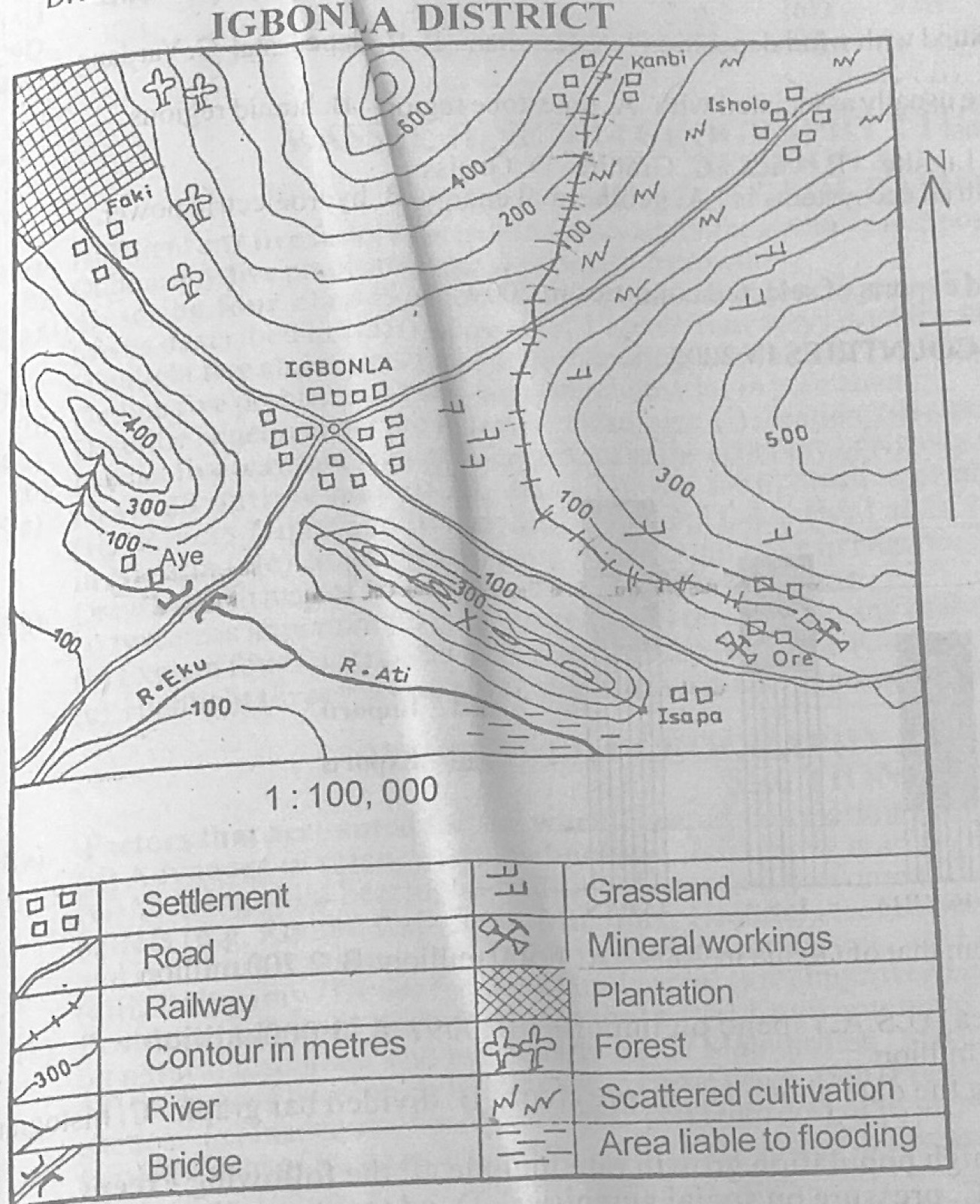
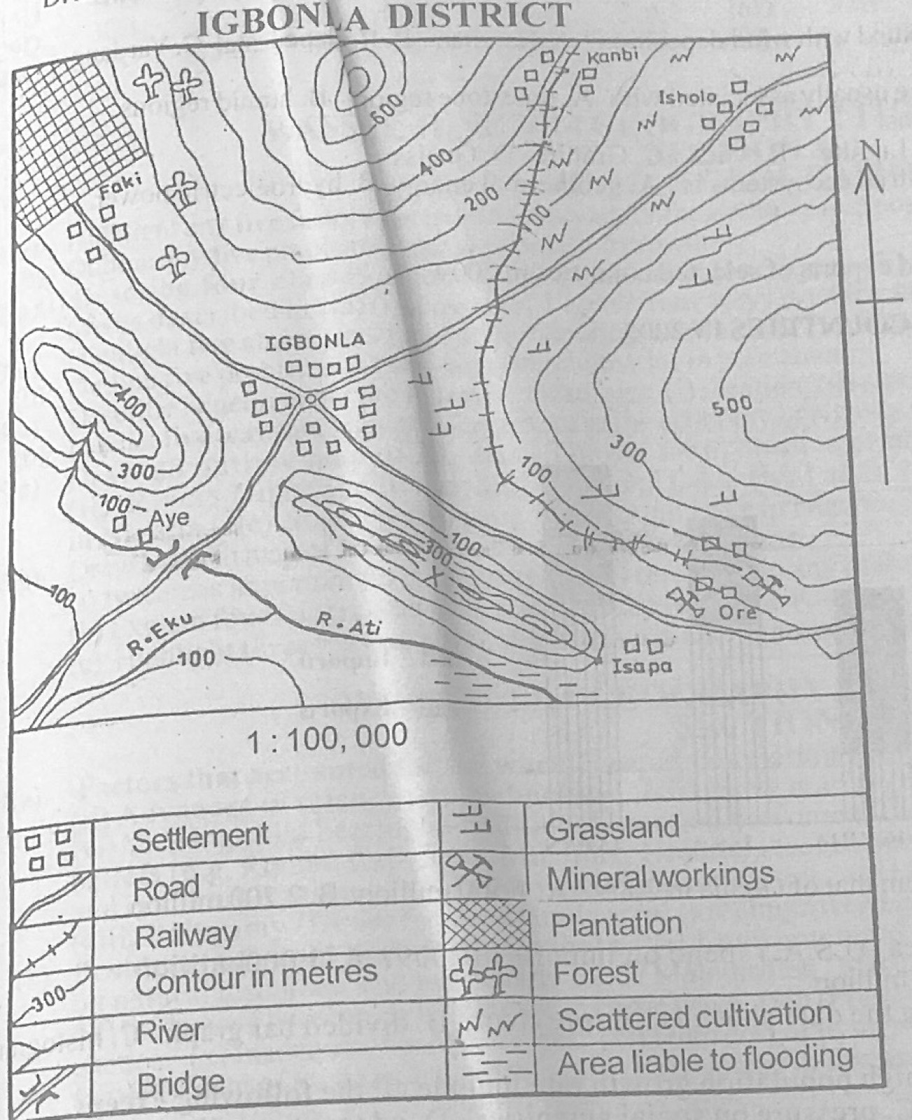
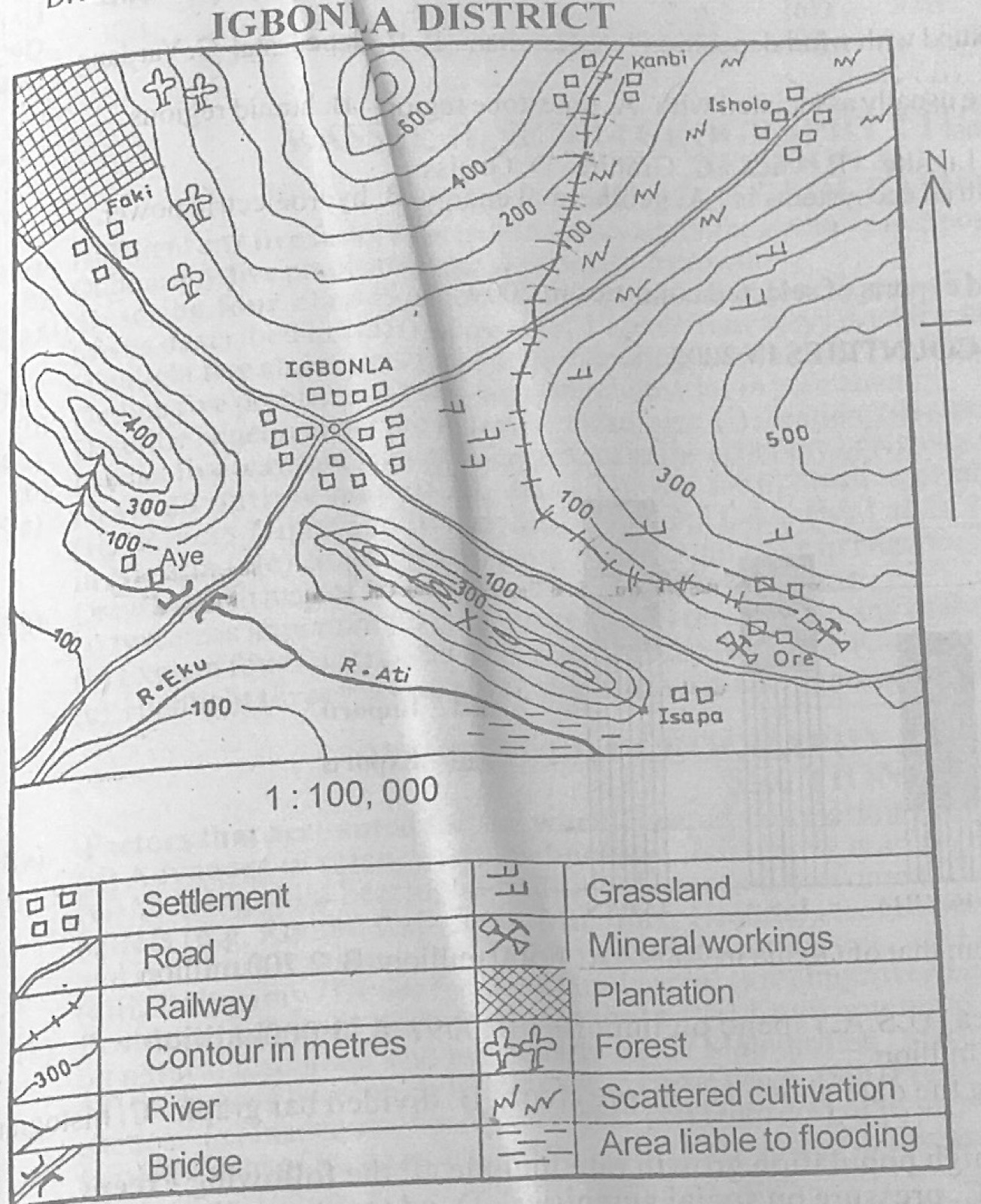
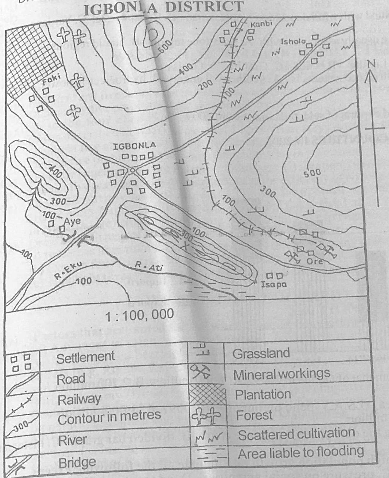
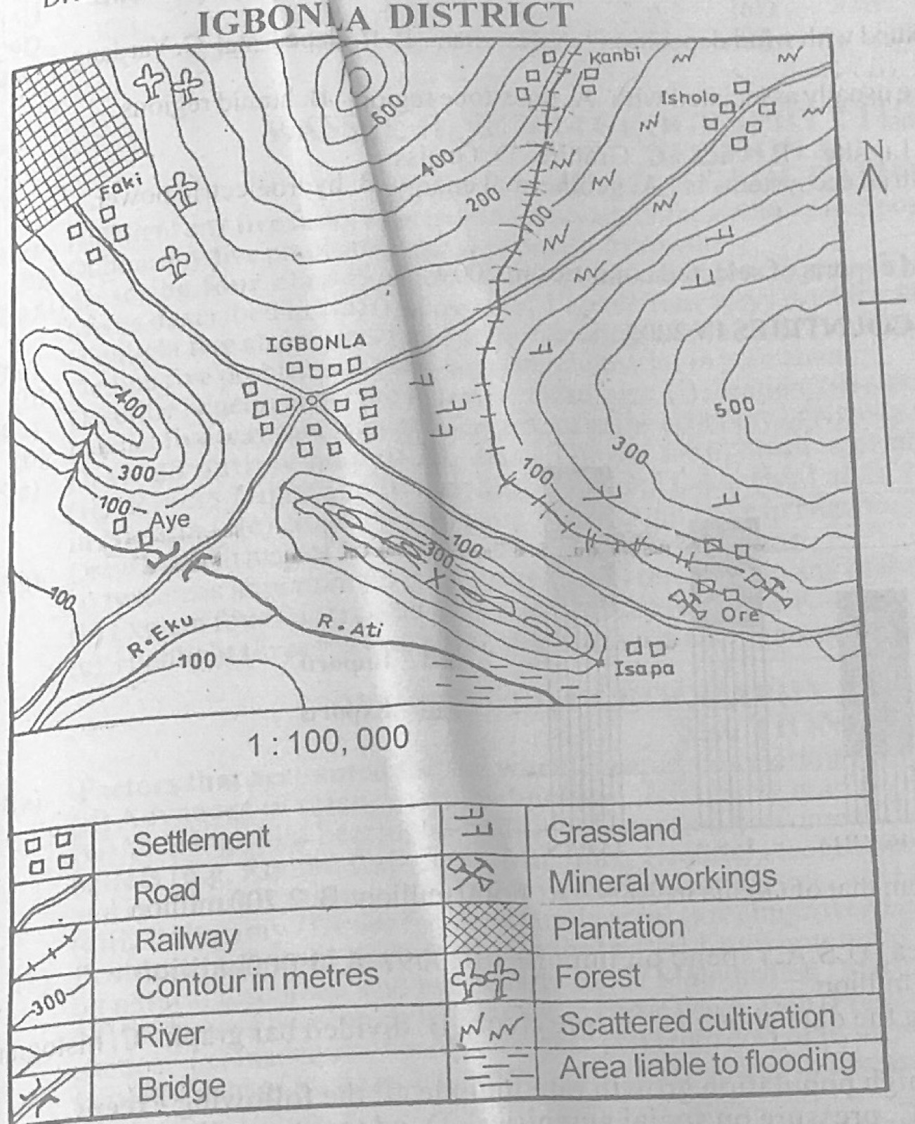
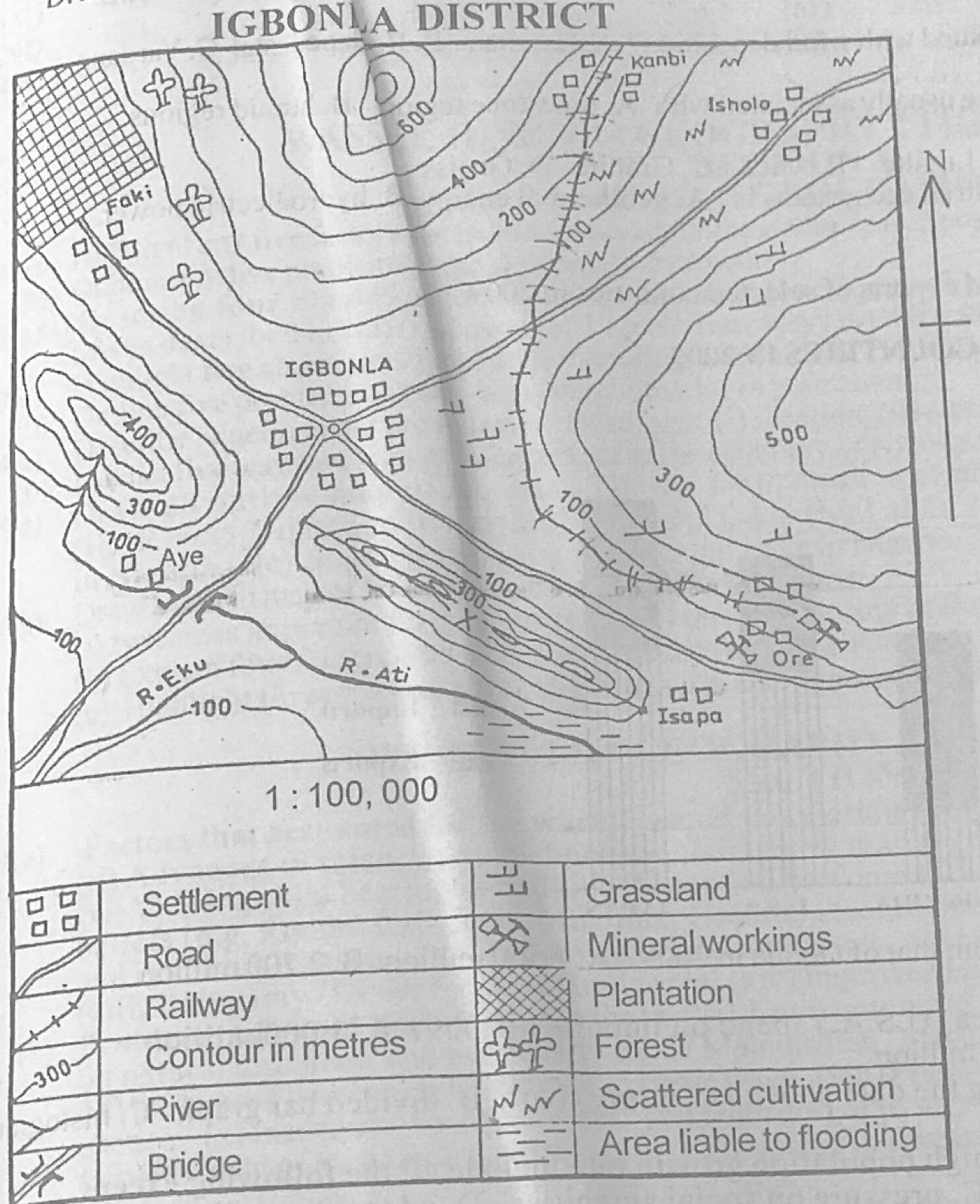
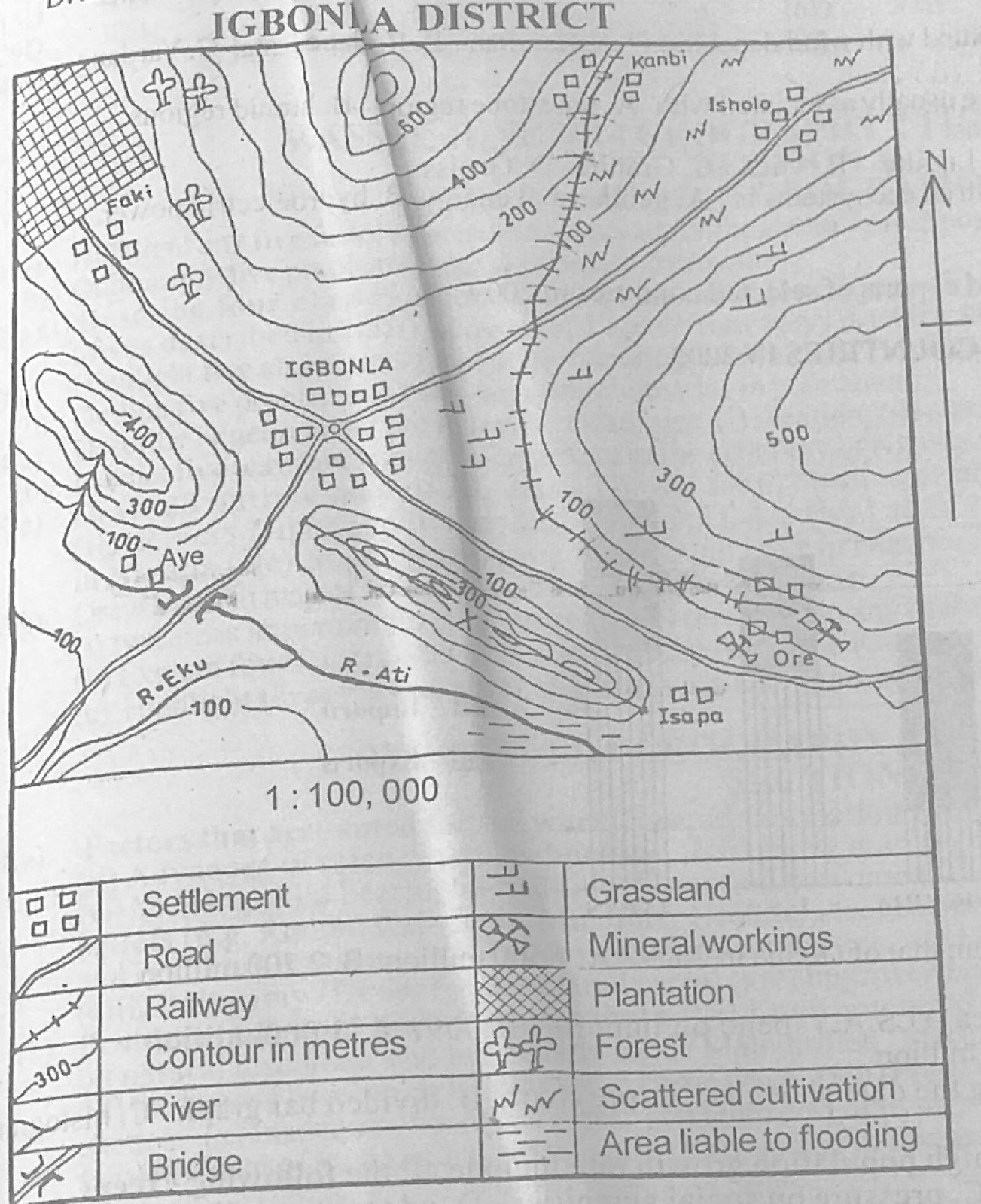
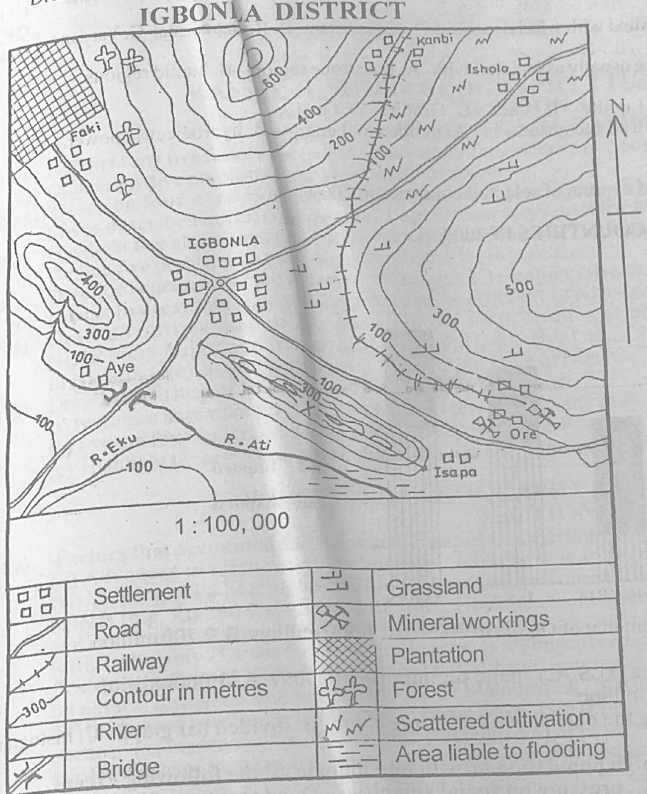
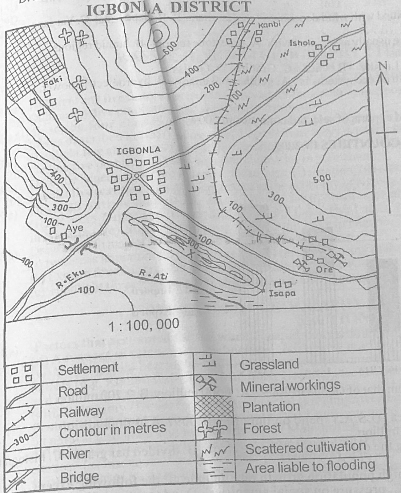
Study the map of IGBONLA DISTRICT (scale 1:100,000) to answer this question. The scale of the map in statement form is one centimetre on the map represents
A.four kilometres on the ground.
B.three kilometres on the ground.
C.one kilometre on the ground.
D.half kilometre on the ground.
Show the answer and explanation
Answer: C (one kilometre on the ground.)
Explanation
1:100,000 means 1 cm on the map = 100,000 cm = 1 km on the ground.
Study the map of IGBONLA DISTRICT (scale 1:100,000) to answer this question. The likely reason for the construction of the railway to link Ore with Kanbi is to
A.provide for the inadequacies in road connections.
B.provide means of distributing manufactured goods from Kanbi.
C.convey mineral products from Ore inland.
D.convey a large population of people out of Ore.
Show the answer and explanation
Answer: C (convey mineral products from Ore inland.)
Explanation
Mineral workings are shown at Ore, and the railway carries the minerals away.
The angular distance of a point on the Earth's surface measured in degrees from the centre of the Earth east or west of the Greenwich Meridian is known as
A.axis.
B.latitude.
C.orbit.
D.longitude.
Show the answer and explanation
Answer: D (longitude.)
Explanation
Longitude is measured east or west of the Greenwich (Prime) Meridian.
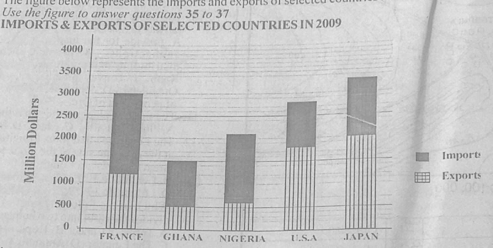
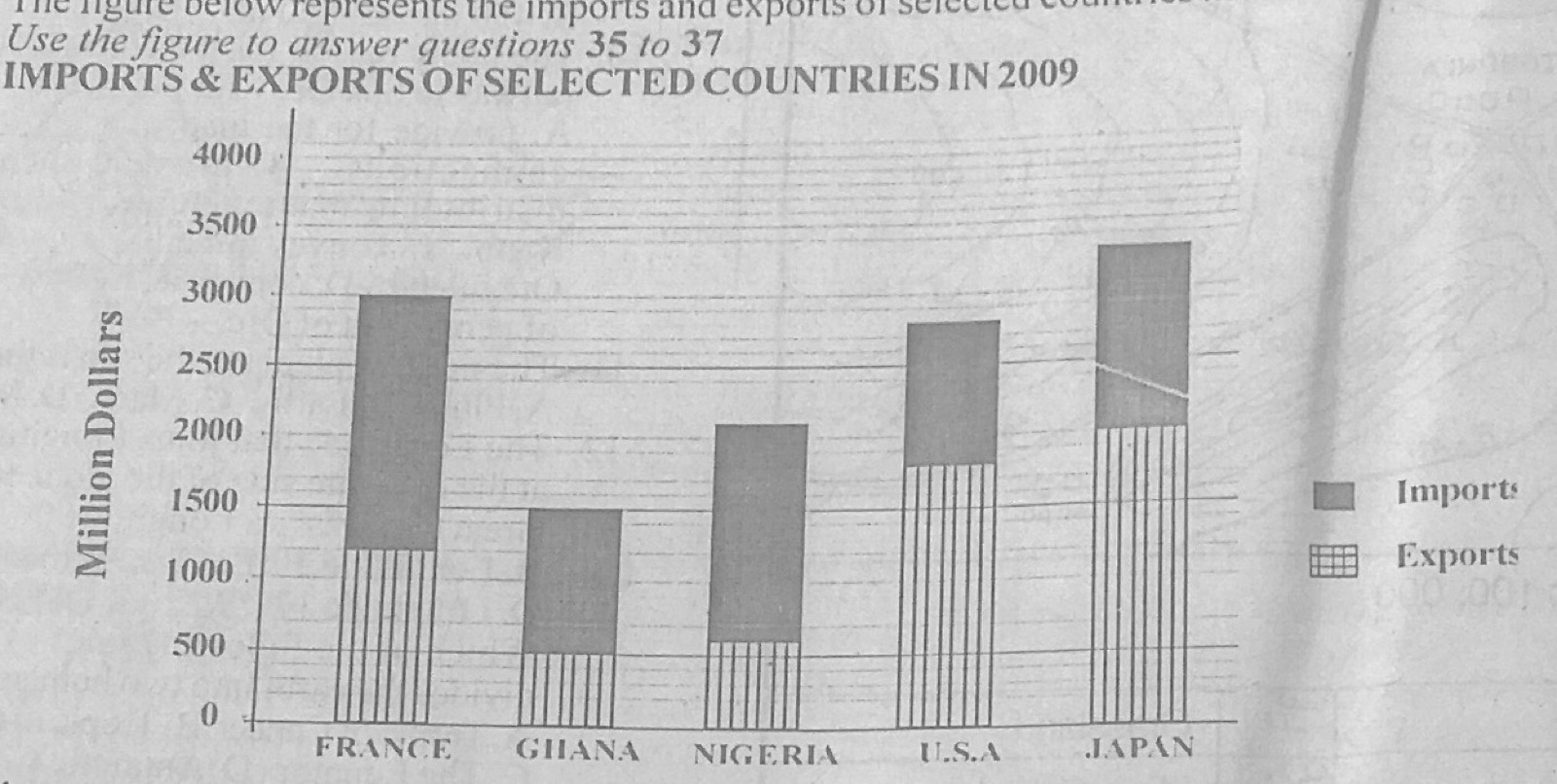
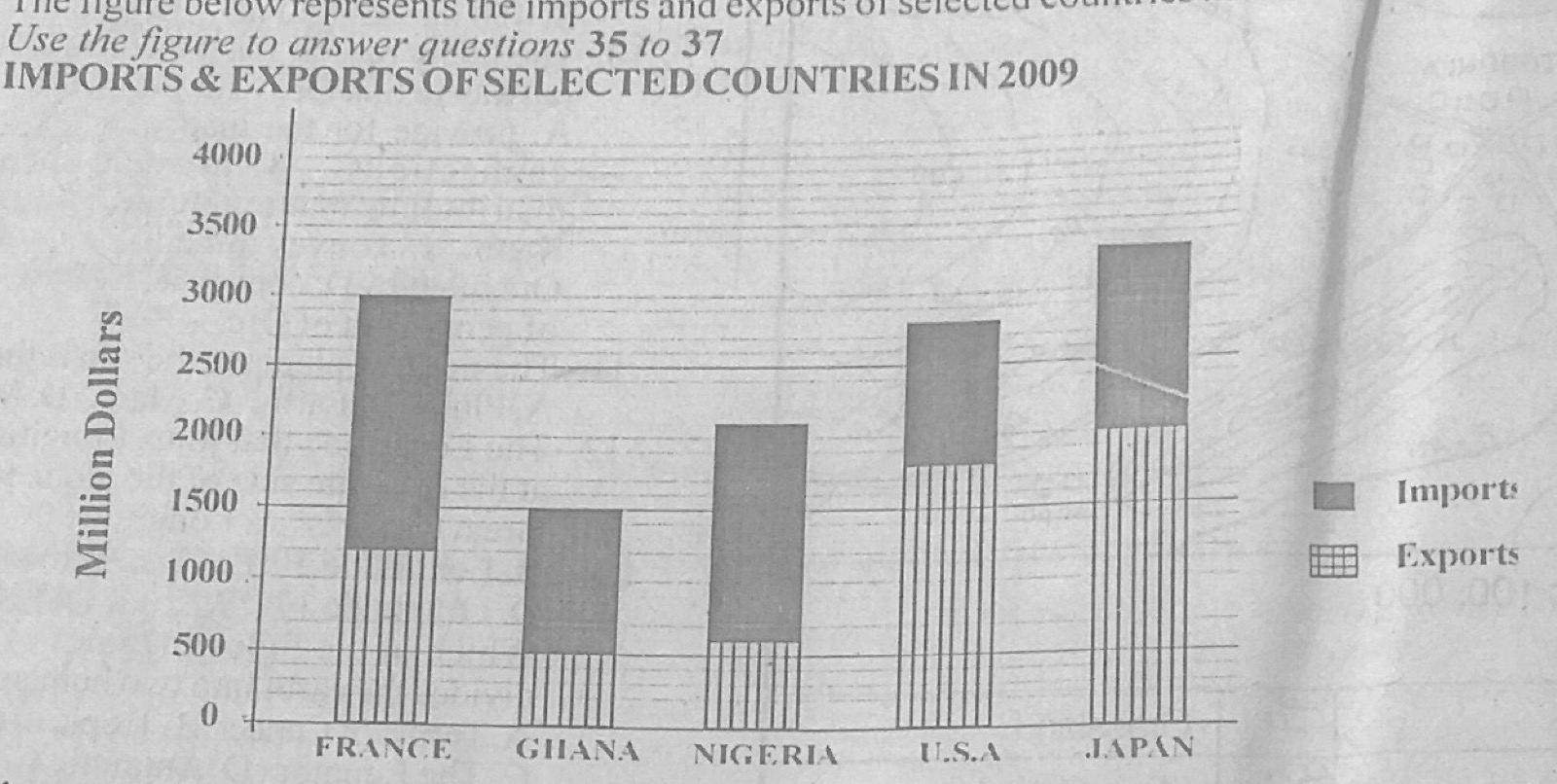
The figure (Imports & exports of selected countries in 2009, in million dollars) represents the imports and exports of selected countries in 2009. Use it to answer this question. By how much is the export of Japan higher than that of Ghana in 2009?
A.1,500 million
B.2,200 million
C.2,800 million
D.3,300 million
Show the answer and explanation
Answer: A (1,500 million)
Explanation
Japan's exports are about 2,000 million and Ghana's about 500 million: 2,000 − 500 = 1,500 million.
The figure (Imports & exports of selected countries in 2009, in million dollars) represents the imports and exports of selected countries in 2009. Use it to answer this question. How much did the United States of America (U.S.A.) spend on imports in 2009?
A.3,000 million
B.2,500 million
C.1,500 million
D.1,000 million
Show the answer and explanation
Answer: D (1,000 million)
Explanation
The U.S.A. bar reaches 2,800; exports make up about 1,800 of it, so imports are about 1,000 million.
The figure (Imports & exports of selected countries in 2009, in million dollars) represents the imports and exports of selected countries in 2009. Use it to answer this question. The statistical method used for representing the data above is
A.pie chart.
B.divided bar graph.
C.histogram.
D.line graph.
Show the answer and explanation
Answer: B (divided bar graph.)
Explanation
Each bar is split into two parts (imports and exports): a divided bar graph.
(a) Highlight any five factors that have accounted for the world's rapid population growth. (b) Outline any five problems of rapid population growth.
Show the model answer
Model answer
(a) Improved medical care and lower death rates (especially infant mortality); better food supply from improved agriculture; improved sanitation and water supply; early marriage and polygamy; religious and cultural beliefs favouring large families; illiteracy and poor family planning; desire for children of a particular sex or as farm labour; improved social amenities; peace and stability. (b) Shortage of food and malnutrition; unemployment; housing shortage and slums; pressure on schools, hospitals and other amenities; high crime rate; pollution and environmental degradation; depletion of resources; spread of diseases; high cost of living; increased government spending.
(a)(i) Describe four classes of towns based on their functions. (ii) Give one example of each of the classes of towns described in 2(a)(i) above. (b) Explain four ways in which rural and urban areas are interdependent.
Show the model answer
Model answer
(a)(i)/(ii) Administrative towns: seats of government (Abuja, Accra); commercial towns: centres of trade and banking (Lagos, Onitsha, Kano); industrial towns: based on manufacturing (Aba, Tema, Manchester); mining towns: grew around mines (Jos, Enugu, Obuasi, Johannesburg); port towns: handle ships and trade (Apapa, Tema, Hamburg); educational towns: universities (Oxford, Nsukka, Ile-Ife); religious towns: pilgrimage centres (Mecca, Jerusalem, Rome); resort towns: tourism (Obudu, Miami); market towns (Onitsha, Kumasi). (b) Rural areas supply food to towns, towns supply manufactured goods to rural areas; rural areas supply raw materials to urban industries; rural areas supply labour, urban areas provide jobs and send money (remittances) back; towns provide services (hospitals, banks, higher schools, markets) used by rural people; urban dwellers invest in and develop their home villages; towns spread new ideas and technology.
(a) Highlight five characteristics of manufacturing industries in Tropical African countries. (b) Outline five problems of manufacturing industries in your country.
Show the model answer
Model answer
(a) Mostly light, consumer-goods industries; concentrated in capital and port cities; mainly import-substitution and processing of agricultural raw materials; small scale and labour intensive; dependence on imported machinery, spare parts and raw materials; much foreign ownership or capital; low technology; operate below installed capacity; produce mainly for home markets. (b) (Nigeria) Erratic power supply; inadequate capital and high interest rates; poor infrastructure (roads, water); shortage of local raw materials and spare parts; shortage of skilled manpower; competition from imported and smuggled goods; low purchasing power; multiple taxes and policy changes; insecurity; corruption.
(a) Describe Nigeria under the following headings: (i) location; (ii) size. (b) In what five ways are highlands important to the economy of Nigeria?
Show the model answer
Model answer
(a)(i) Location: in West Africa, between latitudes 4°N and 14°N and longitudes 3°E and 15°E; bounded by the Republic of Benin to the west, Niger to the north, Chad to the north-east, Cameroon to the east and the Atlantic Ocean (Gulf of Guinea/Bight of Benin and Biafra) to the south. (ii) Size: area of about 923,768 km²; about 1,040 km from north to south and 1,120 km from east to west; coastline about 800 km; one of the largest countries in West Africa and the most populous in Africa; 36 states and FCT. (b) Minerals (tin and columbite on the Jos Plateau, coal at Udi, gold); sources of rivers and sites for HEP and dams (Shiroro); cool climate good for tourism and resorts (Jos, Obudu Cattle Ranch, Mambilla); grazing land free of tsetse; temperate crops (Irish potatoes, tea on Mambilla); forest products; relief rainfall; defence and boundaries.
(a) Draw an outline map of Nigeria. On the map, show and name: (i) the Western Highlands; (ii) Rivers Niger and Benue; (iii) the Kainji Lake; (iv) Lagos. (b) Highlight any three characteristics of rivers in Nigeria. (c) State any two benefits of Kainji Lake to Nigeria.
Show the model answer
Model answer
(a) Map: Western Highlands in the south-west (Oyo, Osun, Ekiti, Kwara); Niger entering from the north-west, through Kainji, to Lokoja and the delta; Benue entering from Cameroon in the east and joining at Lokoja; Kainji Lake on the Niger in Niger/Kwara State; Lagos on the south-west coast. (b) Seasonal regime (high water in the rainy season, low in the dry season); many rise in the central highlands and flow outwards (radial pattern) to the Niger-Benue system, Lake Chad or the sea; rapids and waterfalls in their upper courses; sandbars and silting at their mouths; many short coastal rivers; the Niger forms a large delta. (c) Hydro-electric power; fishing; irrigation; water transport; flood control; tourism (Kainji Lake National Park); water supply.
(a) Draw a sketch map of Nigeria. On the map, show and name: (i) two areas important for cattle rearing; (ii) one town in any of the areas shown in 6(a)(i) above. (b) Explain four factors which encourage cattle rearing in Northern Nigeria. (c) Highlight three reasons why cattle rearing is less important in Southern Nigeria.
Show the model answer
Model answer
(a) Map: e.g. Sokoto-Katsina-Kano plains, Bauchi/Borno (Chad Basin), Jos Plateau, Mambilla Plateau, Adamawa; town such as Kano, Sokoto, Maiduguri or Jos. (b) Extensive grassland and pasture; absence of tsetse fly because of the long dry season; low rainfall reduces diseases such as foot rot; Fulani tradition and skill in herding; flat open plains; large markets in the south and good transport (rail, roads); veterinary services; cattle valued as wealth. (c) Presence of tsetse fly (trypanosomiasis); dense forest with little good pasture; heavy rainfall encourages cattle diseases; land is used mainly for crops, causing conflict with farmers; people are traditionally crop farmers; high cost of feed.
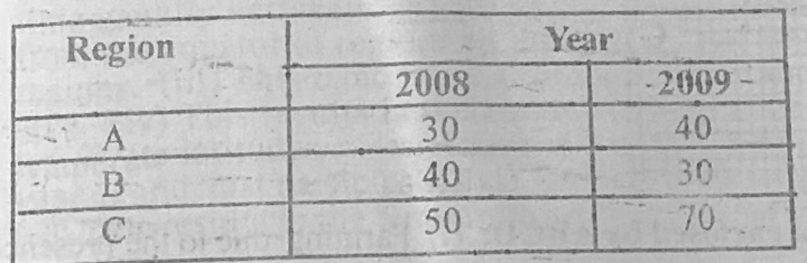
Use the data in the table below to answer the questions that follow. Production of cocoa in country Z (in thousand tonnes) for 2008 and 2009 from three production regions A, B and C. Region A: 2008 30; 2009 40 Region B: 2008 40; 2009 30 Region C: 2008 50; 2009 70 (a) Construct a multiple bar graph to show the data. (b) Outline any three advantages of the method used.
Show the model answer
Model answer
(a) Title; vertical axis 'Production (thousand tonnes)' with a scale such as 1 cm = 10 thousand tonnes from 0 to 70; horizontal axis with regions A, B and C; for each region two bars side by side (2008 and 2009) drawn to the correct heights (A 30 and 40; B 40 and 30; C 50 and 70); different shading for each year with a key; equal bar widths and gaps between regions. (b) Easy to construct; easy to read and understand; makes comparison between years and regions easy; actual values can be read off; shows changes (rise in A and C, fall in B); attractive.
(a) What is a latitude? (b) State any three similarities between lines of longitudes and latitudes. (c) Outline any five ways in which lines of longitudes differ from lines of latitudes.
Show the model answer
Model answer
(a) Latitude is the angular distance of a place north or south of the Equator, measured in degrees from the centre of the earth. (b) Both are imaginary lines; both are measured in degrees; both are used together to locate places (grid reference); both are drawn on maps and globes; both have a starting line of 0° (Equator, Prime Meridian). (c) Longitudes run north-south, latitudes east-west; longitudes meet at the poles, latitudes are parallel and never meet; all longitudes are equal in length (half great circles), latitudes get shorter towards the poles; longitudes go from 0° to 180° east and west, latitudes from 0° to 90° north and south; longitudes are used to calculate time, latitudes to tell climate zones and distance north-south; every longitude with its opposite forms a great circle, only the Equator among latitudes is a great circle; distance between longitudes decreases towards the poles, between latitudes it is constant (about 111 km).
(a) Define climate. (b) With the aid of a diagram, describe how latitudes influence temperature. (c) Calculate the temperature at a coastal mountain peak of height 6000 metres when the temperature at sea level is 40°C.
Show the model answer
Model answer
(a) Climate is the average weather conditions (temperature, rainfall, pressure, wind, humidity) of a place over a long period, usually about 35 years. (b) Near the Equator the sun's rays are vertical (overhead) and concentrated on a small area and pass through less atmosphere, so temperatures are high; towards the poles the rays are slanting, spread over a larger area and pass through more atmosphere (more absorption and reflection), so temperatures are lower; temperature therefore decreases from the Equator towards the poles. Diagram of the globe with vertical and oblique rays covering different areas. (c) Temperature falls about 6.5°C for every 1,000 m: 6,000 ÷ 1,000 × 6.5 = 39°C fall; temperature at the peak = 40 − 39 = 1°C.
Describe chemically formed sedimentary rocks under the following headings: (a) mode of formation; (b) examples; (c) importance.
Show the model answer
Model answer
(a) Formed when minerals dissolved in water are precipitated or left behind as the water evaporates (e.g. in lakes or enclosed seas in hot dry areas), or by chemical reactions; the deposits harden in layers. (b) Rock salt (halite), gypsum, potash, chalk/limestone of chemical origin, dolomite, trona, ironstone, flint, nitrates. (c) Rock salt for cooking and the chemical industry; gypsum for cement and plaster of Paris; potash and nitrates for fertilisers; limestone for cement and lime; trona for soap and glass; export earnings and employment.
Explain the occurrence of drought under the following headings: (a) causes; (b) area affected; (c) effects; (d) control.
Show the model answer
Model answer
(a) Long absence or failure of rainfall; late onset or early end of rains; high temperatures and evaporation; low humidity and little cloud; deforestation and desertification; climate change; shift in pressure belts (ITD not moving far north). (b) Sahel and Sudan savanna of West Africa (northern Nigeria, Niger, Mali, Chad, Burkina Faso), Horn of Africa (Ethiopia, Somalia), Kalahari region, Australia interior, parts of India. (c) Crop failure, famine and malnutrition; death of livestock; drying up of rivers, lakes and wells; migration of people and animals; desertification; conflict between farmers and herders; poverty and loss of income; diseases. (d) Irrigation and dams to store water; afforestation and shelter belts; drought-resistant crops; water conservation; controlled grazing; cloud seeding; early warning and food storage; public education.
(a) List three processes of river erosion. (b) Outline four characteristics of each of the following sections of a river valley: (i) upper course; (ii) middle course; (iii) lower course.
Show the model answer
Model answer
(a) Hydraulic action; corrasion (abrasion); attrition; solution (corrosion). (b)(i) Upper course: steep gradient; fast flow; mainly vertical (downward) erosion; narrow, steep-sided V-shaped valley; interlocking spurs; waterfalls, rapids, potholes and gorges; small volume; large boulders. (ii) Middle course: gentler gradient; lateral erosion widens the valley; larger volume from tributaries; meanders begin; river cliffs and slip-off slopes; some deposition; wider, open V-shaped valley with small floodplain. (iii) Lower course: very gentle gradient; slow flow; deposition is the main work; wide flat floodplain; large meanders and ox-bow lakes; levees; braided channels; delta or estuary at the mouth; largest volume and fine load.
(a) With the aid of a diagram, describe water table. (b) Outline three factors that influence the depth of water table.
Show the model answer
Model answer
(a) The water table is the upper surface of the zone of saturation in permeable rock, below which all pore spaces are filled with water; above it is the zone of aeration (unsaturated); it roughly follows the shape of the land surface, being higher under hills and nearer the surface in valleys; it rises in the wet season and falls in the dry season (permanent and intermittent saturation zones); where it meets the surface springs, swamps, lakes or rivers form. Diagram showing land surface, zone of aeration, water table, zone of saturation, impermeable rock, well and spring. (b) Amount and season of rainfall; permeability and porosity of rocks; relief/slope of the land; vegetation cover; rate of evaporation and temperature; human use (wells, boreholes, irrigation); nearness to rivers, lakes or the sea; tides near coasts.