WAEC Geography 2003 past questions and answers

62 questions. Try each one, then open the answer to check yourself and read the explanation.

Question 2

Map Scale, Distance and Direction

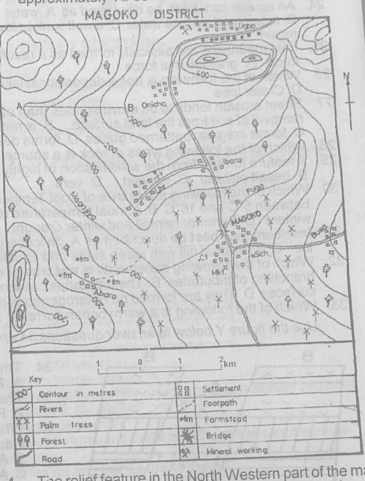
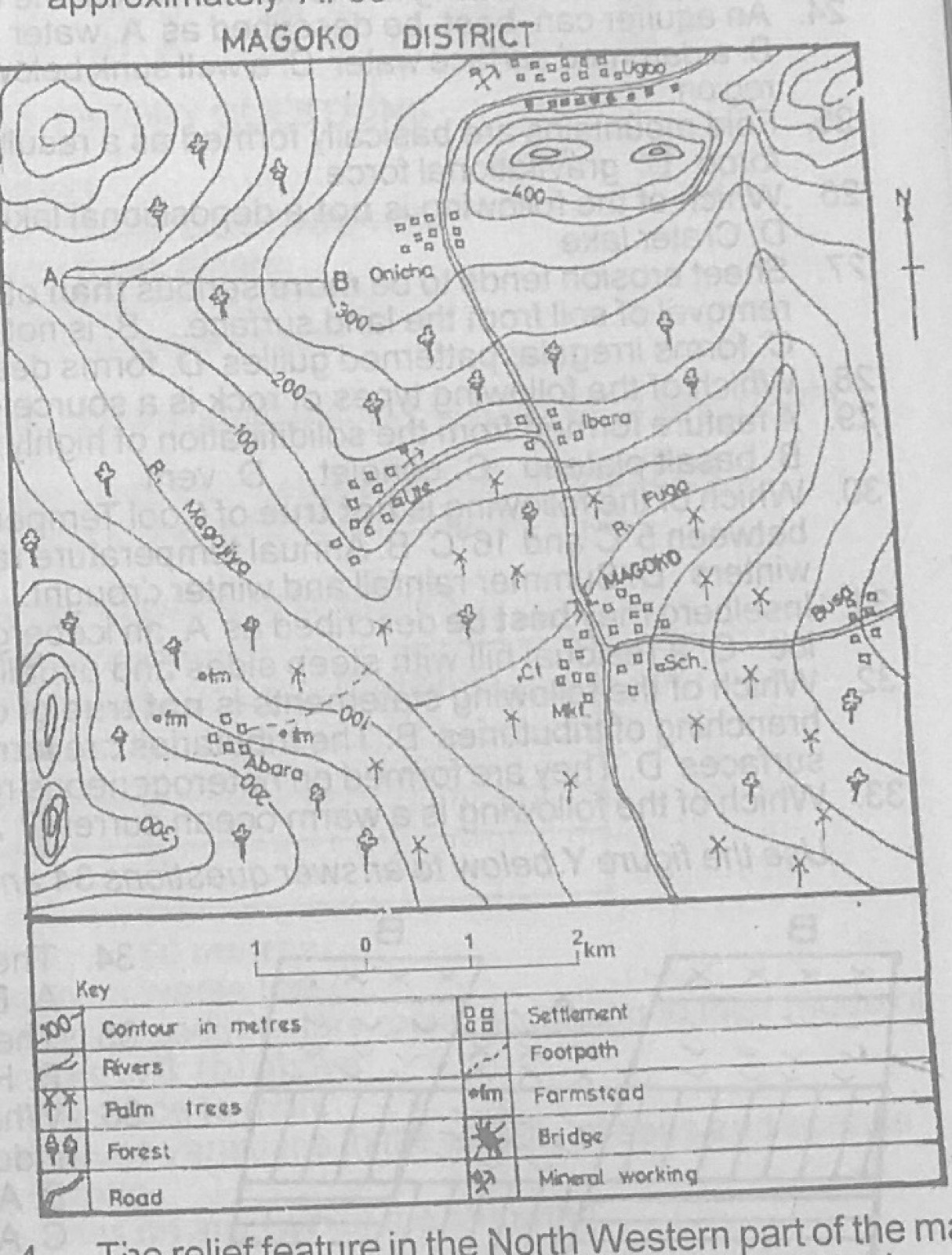
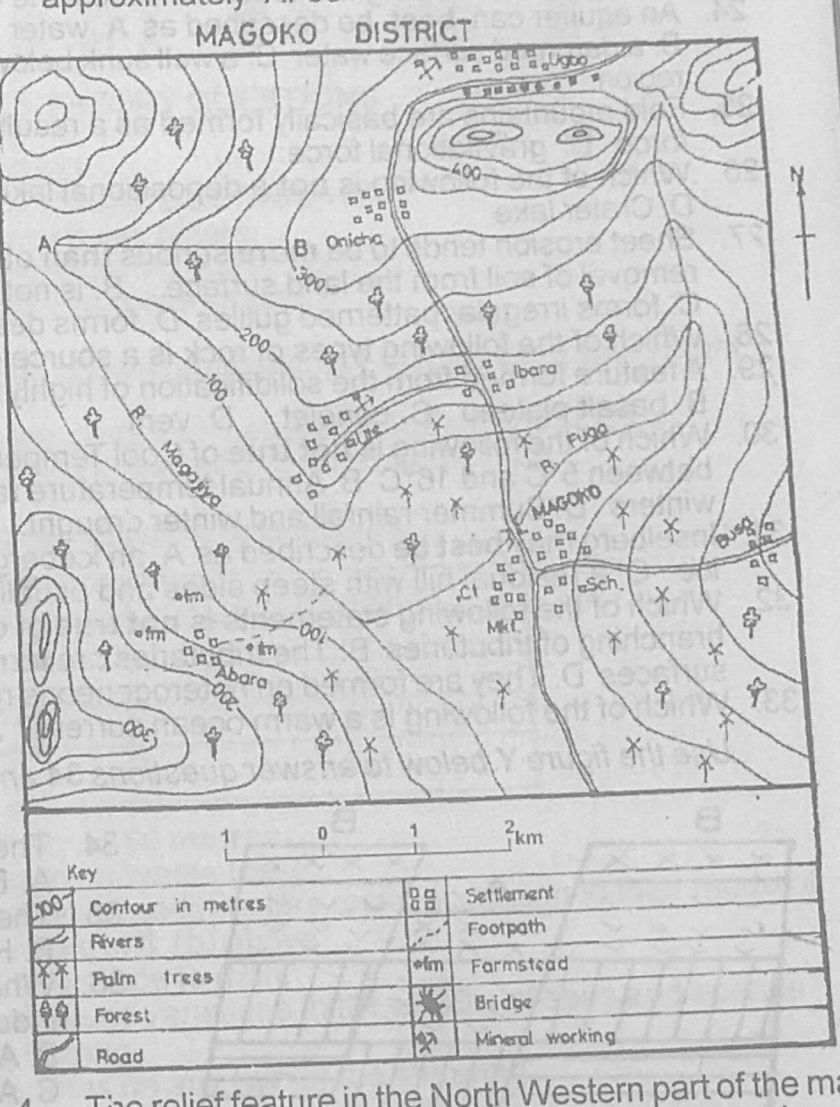
Study the map of MAGOKO DISTRICT to answer this question. What is the approximate distance by road from Ute to Ibara?

Diagram for this question
  1. A.2.25 km
  2. B.3.50 km
  3. C.5.50 km
  4. D.6.00 km
Show the answer and explanation

Answer: A (2.25 km)

Explanation

Follow the road from Ute north-east to Ibara with a strip of paper and lay it on the linear scale: a little over 2 km.

Open this question

Question 3

Map Scale, Distance and Direction

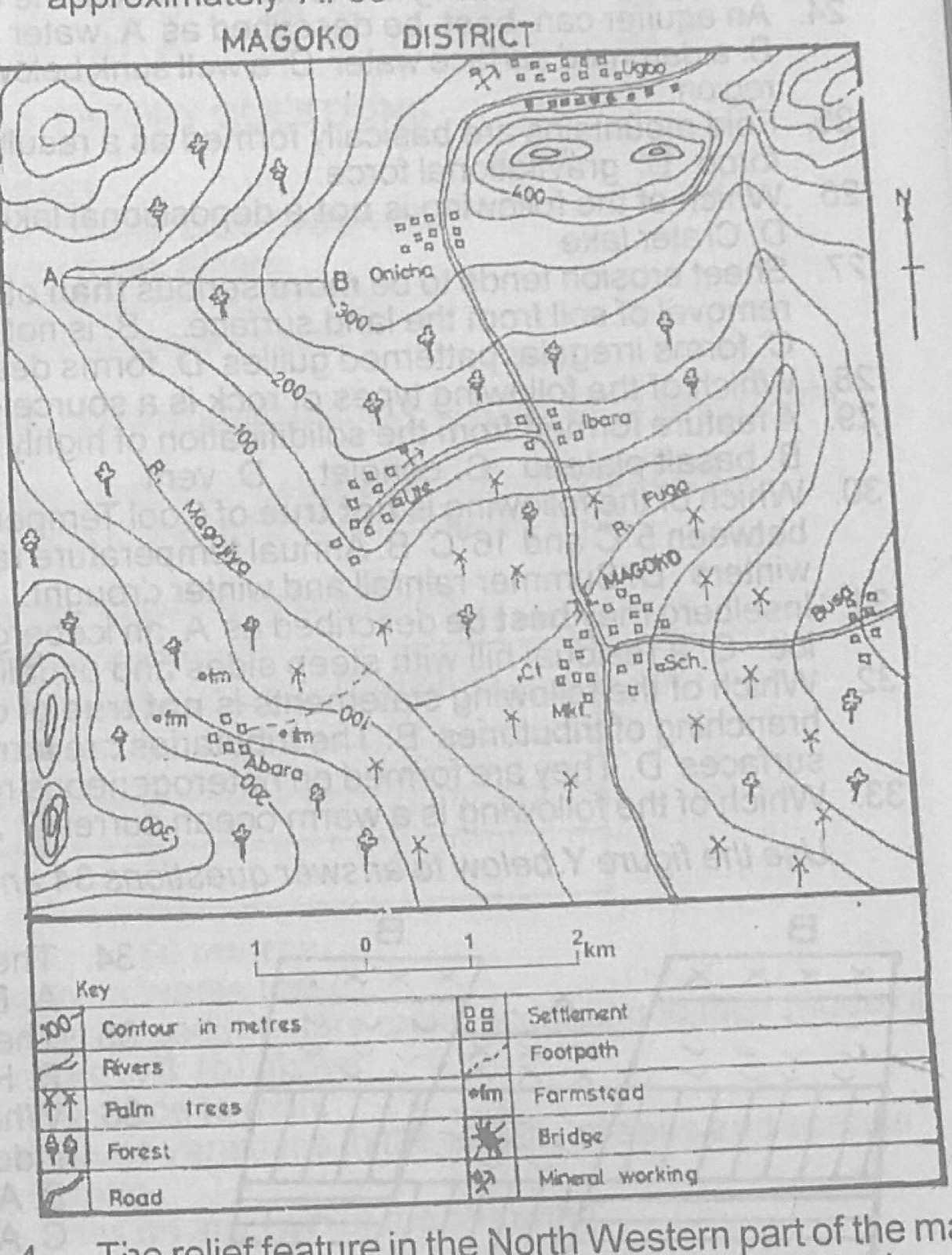
Study the map of MAGOKO DISTRICT to answer this question. The angular bearing of Busa from Abara is approximately

Diagram for this question
  1. A.30°
  2. B.40°
  3. C.60
  4. D.80°
Show the answer and explanation

Answer: D (80°)

Explanation

Busa lies almost due east of Abara, slightly to the north, so its bearing measured clockwise from north is about 80°.

Open this question

Question 4

Relief and Map Interpretation

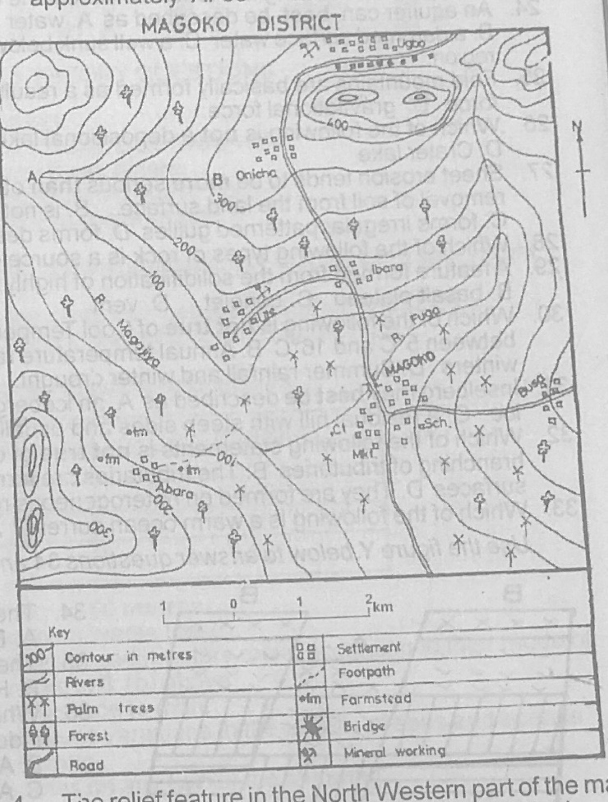
Study the map of MAGOKO DISTRICT to answer this question. The relief feature in the North Western part of the map is called a

Diagram for this question
  1. A.ridge
  2. B.plateau
  3. C.conical hill
  4. D.dissected highland
Show the answer and explanation

Answer: C (conical hill)

Explanation

In the north-west the contours form small closed rings one inside another: a conical hill.

Open this question

Question 5

Relief and Map Interpretation

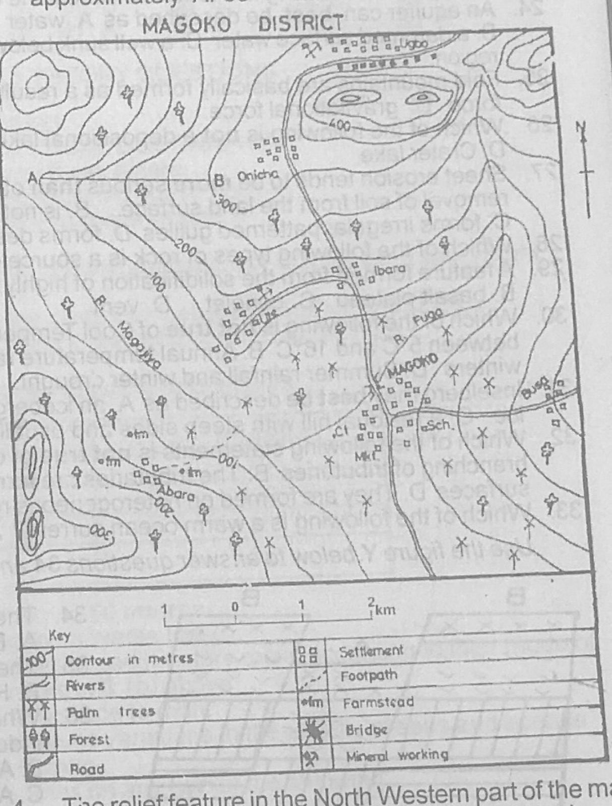
Study the map of MAGOKO DISTRICT to answer this question. The feature marked A - B is called a

Diagram for this question
  1. A.headland
  2. B.ridge
  3. C.spur
  4. D.cliff
Show the answer and explanation

Answer: C (spur)

Explanation

Between A and B the contours bend outwards from the higher ground, forming a tongue of land sloping down: a spur.

Open this question

Question 6

Relief and Map Interpretation

Study the map of MAGOKO DISTRICT to answer this question. In which of the following towns is a palm oil processing factory likely to be located?

Diagram for this question
  1. A.Abara
  2. B.Magoko
  3. C.Ute
  4. D.Ibara
Show the answer and explanation

Answer: B (Magoko)

Explanation

Magoko is the largest town, on the road, and is surrounded by palm trees that would supply the factory.

Open this question

Question 7

Relief and Map Interpretation

Study the map of MAGOKO DISTRICT to answer this question. Ute and Ugbo can best be described as

Diagram for this question
  1. A.farm setilements
  2. B.mining settlements
  3. C.port settlements
  4. D.fishing settlements
Show the answer and explanation

Answer: B (mining settlements)

Explanation

Mineral working symbols are printed beside both Ute and Ugbo.

Open this question

Question 9

Relief and Map Interpretation

Study the map of MAGOKO DISTRICT to answer this question. Which of the following towns is not visible from Ibara?

Diagram for this question
  1. A.Ute
  2. B.Ugbo
  3. C.Magoko
  4. D.Abara
Show the answer and explanation

Answer: B (Ugbo)

Explanation

The hill (over 400 m) in the north stands between Ibara and Ugbo and blocks the view.

Open this question

Question 10

Map Scale, Distance and Direction

Study the map of MAGOKO DISTRICT to answer this question. The total area covered by the map is approximately

Diagram for this question
  1. A.250.00 km²
  2. B.120.25km²
  3. C.90.45 km²
  4. D.66.25 km²
Show the answer and explanation

Answer: D (66.25 km²)

Explanation

Measure the length and width of the map frame against the linear scale and multiply them.

Open this question

Question 11

Climate

Study the climatic data for station X: Month J F M A M J J A S O N D; Rainfall (mm) 50, 70, 130, 170, 200, 300, 350, 300, 350, 250, 200, 150; Temperature (°C) 21, 20, 22, 20, 20, 20, 20, 20, 21, 22, 22, 22. The total annual rainfall for the station is

Diagram for this question
  1. A.210 mm
  2. B.300 mm
  3. C.2500 mm
  4. D.2520 mm.
Show the answer and explanation

Answer: D (2520 mm.)

Explanation

Add the twelve monthly totals: 50 + 70 + 130 + 170 + 200 + 300 + 350 + 300 + 350 + 250 + 200 + 150 = 2520 mm.

Open this question

Question 12

Climate

Study the climatic data for station X: Month J F M A M J J A S O N D; Rainfall (mm) 50, 70, 130, 170, 200, 300, 350, 300, 350, 250, 200, 150; Temperature (°C) 21, 20, 22, 20, 20, 20, 20, 20, 21, 22, 22, 22. The mean annual temperature for the station is

Diagram for this question
  1. A.25.0°C
  2. B.22.0°C
  3. C.20.8°C
  4. D.2.0°C.
Show the answer and explanation

Answer: C (20.8°C)

Explanation

Add the twelve temperatures (250°C) and divide by 12: about 20.8°C.

Open this question

Question 13

Climate

Study the climatic data for station X: Month J F M A M J J A S O N D; Rainfall (mm) 50, 70, 130, 170, 200, 300, 350, 300, 350, 250, 200, 150; Temperature (°C) 21, 20, 22, 20, 20, 20, 20, 20, 21, 22, 22, 22. What is the annual temperature range for station X?

Diagram for this question
  1. A.2°C
  2. B.3°C
  3. C.4°C
  4. D.5°C.
Show the answer and explanation

Answer: A (2°C)

Explanation

Range = highest minus lowest monthly temperature = 22°C − 20°C = 2°C.

Open this question

Question 14

The Earth and Solar System

Which of the following planets is closest to the sun?

  1. A.Pluto
  2. B.Neptune
  3. C.Uranus
  4. D.Saturn
Show the answer and explanation

Answer: D (Saturn)

Explanation

Of these, Saturn (6th planet) is nearest the sun; Uranus, Neptune and Pluto lie farther out.

Open this question

Question 15

Structure of the Earth

The combination of Sial and Sima constitute the

  1. A.hydrosphere
  2. B.biosphere
  3. C.lithosphere
  4. D.atmosphere
Show the answer and explanation

Answer: C (lithosphere)

Explanation

Sial and sima are the rock layers of the crust, which form the lithosphere.

Open this question

Question 16

Rocks

Chalk is a good example of

  1. A.plutonic igneous rock
  2. B.organically formed sedimentary rock
  3. C.mechanically formed sedimentary rock
  4. D.extrusive igneous rock.
Show the answer and explanation

Answer: B (organically formed sedimentary rock)

Explanation

Chalk is made from the shells and skeletons of tiny sea creatures, so it is an organically formed sedimentary rock.

Open this question

Question 17

Rocks

Which of the following is not a metamorphic rock?

  1. A.Grit
  2. B.Schist
  3. C.Marble
  4. D.Slate
Show the answer and explanation

Answer: A (Grit)

Explanation

Grit is a coarse sandstone (sedimentary); schist, marble and slate are metamorphic.

Open this question

Question 18

Latitude, Longitude and Time

As a volley ball match was being played in town Y, the referee observed that the local time was noon while the Greenwich Mean Time was 22.00 hours on the same day. What is the longitude of town Y?

  1. A.20°E
  2. B.20°W
  3. C.145°E
  4. D.150°W.
Show the answer and explanation

Answer: D (150°W.)

Explanation

Town Y is 10 hours behind GMT, so it is west of Greenwich: 10 × 15° = 150°W.

Open this question

Question 19

Weathering, Erosion and Mass Movement

The process of weathering in limestone region is mainly

  1. A.hydration
  2. B.exfoliation
  3. C.solution
  4. D.oxidation
Show the answer and explanation

Answer: C (solution)

Explanation

Rainwater with dissolved carbon dioxide dissolves limestone (carbonation-solution).

Open this question

Question 21

Wind and Desert Landforms

Abrasion, attrition and deflation are processes of

  1. A.river erosion
  2. B.coastal erosion
  3. C.wind erosion
  4. D.glacial erosion.
Show the answer and explanation

Answer: C (wind erosion)

Explanation

Deflation (blowing away of loose particles) happens only with wind, which also erodes by abrasion and attrition.

Open this question

Question 22

Rivers and River Landforms

One of the features found in the upper course of a river is

  1. A.gorge
  2. B.u-shaped valley
  3. C.meander
  4. D.levée
Show the answer and explanation

Answer: A (gorge)

Explanation

Rapid vertical erosion in the upper course cuts deep, narrow gorges; meanders and levées belong to the lower course.

Open this question

Question 23

Underground Water and Karst

Which of the following is a feature of limestone regions?

  1. A.Batholith
  2. B.Cinder cone
  3. C.Crater
  4. D.Stalagmite
Show the answer and explanation

Answer: D (Stalagmite)

Explanation

Stalagmites grow up from cave floors in limestone areas.

Open this question

Question 24

Underground Water and Karst

An aquifer can best be described as

  1. A.water bearing rock in between two impervious layers of rock
  2. B.a dammed surface water
  3. C.a well sunk below an impervious stratum of rock
  4. D.a beheaded river in a limestone region.
Show the answer and explanation

Answer: A (water bearing rock in between two impervious layers of rock)

Explanation

An aquifer is a permeable rock layer holding water, usually trapped between impermeable layers.

Open this question

Question 25

Earth Movements and Vulcanicity

Fold mountains are basically formed as a result of

  1. A.coriolis force
  2. B.tensional force
  3. C.compressional force
  4. D.gravitational force.
Show the answer and explanation

Answer: C (compressional force)

Explanation

Fold mountains form when compressional forces squeeze rock layers into folds.

Open this question

Question 26

Oceans and Lakes

Which of the following is not a depositional lake?

  1. A.Flood plain lake
  2. B.Ox-bow lake
  3. C.Barrier lake
  4. D.Crater lake
Show the answer and explanation

Answer: D (Crater lake)

Explanation

A crater lake fills a volcanic crater; flood-plain, ox-bow and barrier lakes are formed by deposits blocking water.

Open this question

Question 27

Environmental Hazards and Conservation

Sheet erosion tends to be more serious than other forms of erosion because it

  1. A.involves more widespread removal of soil from the land surface
  2. B.is not controllable
  3. C.forms irregular patterned gullies
  4. D.forms deep trenches which cut through topsoil and subsoil.
Show the answer and explanation

Answer: A (involves more widespread removal of soil from the land surface)

Explanation

Sheet erosion quietly removes a thin layer of fertile topsoil over a wide area before it is noticed.

Open this question

Question 28

Rocks

Which of the following types of rock is a source of energy?

  1. A.Sandstone
  2. B.Coal
  3. C.Granite
  4. D.Graphite
Show the answer and explanation

Answer: B (Coal)

Explanation

Coal is burnt for heat and power.

Open this question

Question 29

Earth Movements and Vulcanicity

A feature formed from the solidification of highly fluid basic lava on the earth's surface is known as a

  1. A.laccolith
  2. B.basalt plateau
  3. C.conelet
  4. D.vent
Show the answer and explanation

Answer: B (basalt plateau)

Explanation

Runny basic lava spreads widely before cooling and builds up into a lava (basalt) plateau.

Open this question

Question 30

Climate

Which of the following is not true of Cool Temperate Western Margin Climate?

  1. A.Mean annual temperature between 5°C and 16°C
  2. B.Annual temperature range of 13°C
  3. C.Moderately warm summers and fairly mild winters
  4. D.Summer rainfall and winter drought.
Show the answer and explanation

Answer: D (Summer rainfall and winter drought.)

Explanation

This climate has rain all year with a winter maximum, so 'summer rainfall and winter drought' is false.

Open this question

Question 31

Weathering, Erosion and Mass Movement

Inselberg may best be described as

  1. A.an iceberg left over by moving ice sheet.
  2. B.a barge left on water by melting ice
  3. C.a residual hill with steep sides and usually exposed by denudation
  4. D.mountains of deposition.
Show the answer and explanation

Answer: C (a residual hill with steep sides and usually exposed by denudation)

Explanation

An inselberg is a steep-sided hill of hard rock left standing after the land around it has been worn down.

Open this question

Question 32

Rivers and River Landforms

Which of the following statements is not true of dendritic pattern of drainage?

  1. A.It is characterized by irregular branching of tributaries
  2. B.The tributaries are formed at an acute angle
  3. C.They develop on homogeneous rock surfaces
  4. D.They are formed on heterogeneous rock surfaces.
Show the answer and explanation

Answer: D (They are formed on heterogeneous rock surfaces.)

Explanation

A dendritic pattern develops where the rock is uniform (homogeneous), so 'formed on heterogeneous rock surfaces' is the false statement.

Open this question

Question 33

Oceans and Lakes

Which of the following is a warm ocean current?

  1. A.Labrador
  2. B.Canaries
  3. C.Peruvian
  4. D.Mozambique
Show the answer and explanation

Answer: D (Mozambique)

Explanation

The Mozambique current flows south from the tropics along East Africa and is warm; the others are cold.

Open this question

Question 34

Earth Movements and Vulcanicity

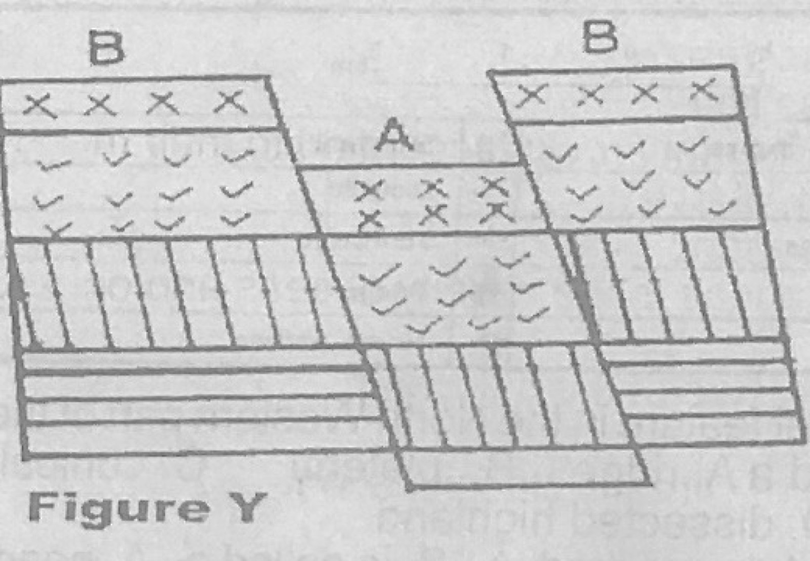
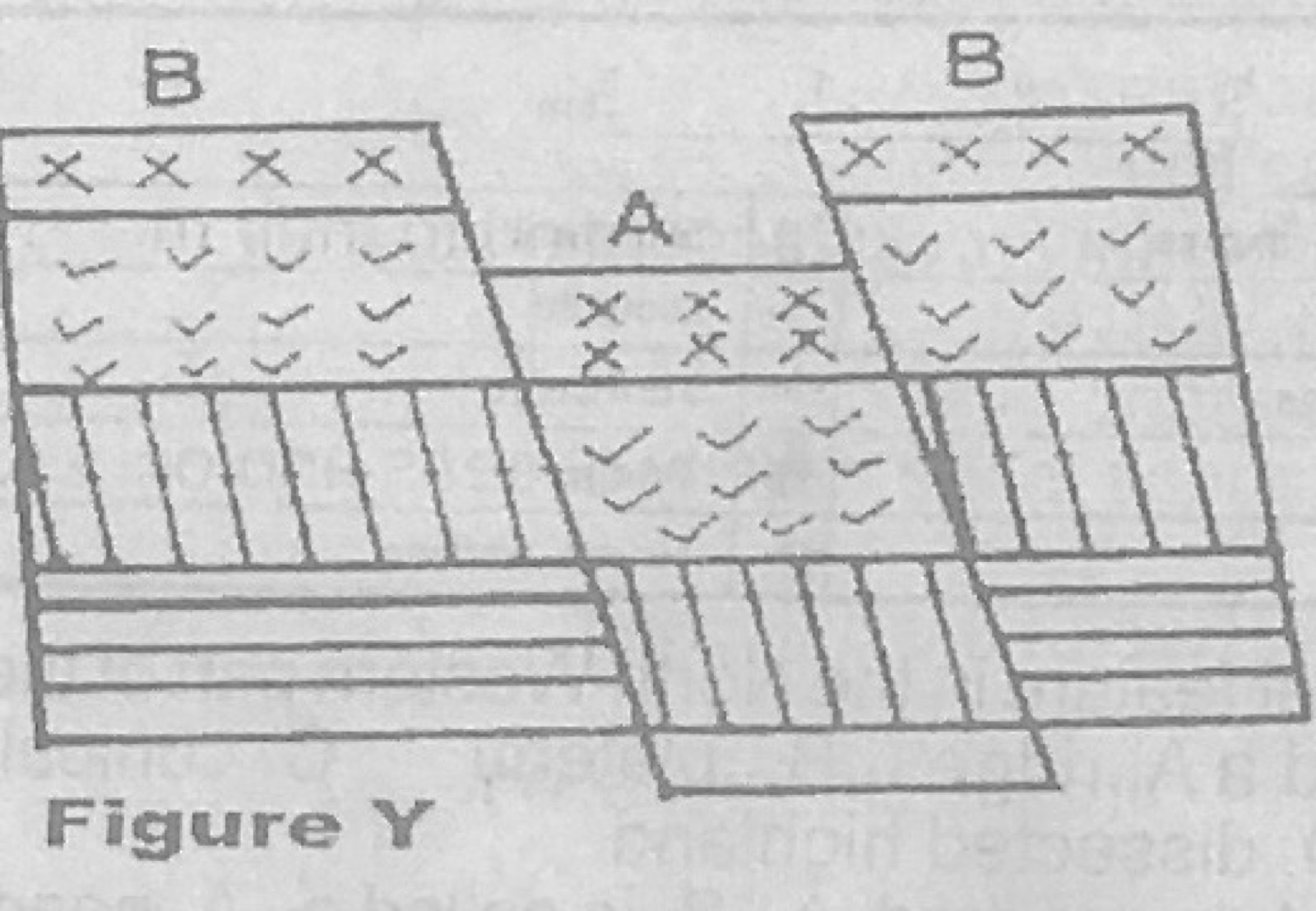
Use Figure Y (a block diagram with blocks marked A and B) to answer this question. The area marked A in the diagram can be described as

Diagram for this question
  1. A.Escarpment
  2. B.Fault block
  3. C.Rift valley
  4. D.Block mountain
Show the answer and explanation

Answer: C (Rift valley)

Explanation

Block A has sunk down between two faults, below the blocks on either side: a rift valley.

Open this question

Question 35

Earth Movements and Vulcanicity

Use Figure Y (a block diagram with blocks marked A and B) to answer this question. The area marked B in the diagram is an example of a

Diagram for this question
  1. A.Cuesta
  2. B.Horst
  3. C.Embarkment
  4. D.Rift valley system
Show the answer and explanation

Answer: B (Horst)

Explanation

Blocks B stand up above the sunken block between faults, so each is a horst (block mountain).

Open this question

Question 36

Manufacturing Industry

Which of the following is a feature of heavy manufacturing industries?

  1. A.Small labour force mainly from the family members
  2. B.Articles produced are in small quantities
  3. C.A limited space for workshop
  4. D.Dependence on electricity powered equipment.
Show the answer and explanation

Answer: D (Dependence on electricity powered equipment.)

Explanation

Heavy industries use large power-driven machines; the other options describe cottage industries.

Open this question

Question 37

Geography of Africa

Which of the following countries is the leading producer of petroleum?

  1. A.Algeria
  2. B.Libya
  3. C.Egypt
  4. D.Gabon
Show the answer and explanation

Answer: B (Libya)

Explanation

Of these countries, Libya produced the most crude oil at the time of this paper.

Open this question

Question 38

The Ecosystem

The ultimate source of energy in the biosphere is

  1. A.the moon
  2. B.the sun
  3. C.petroleum
  4. D.electricity
Show the answer and explanation

Answer: B (the sun)

Explanation

All food chains start with plants capturing the sun's energy.

Open this question

Question 39

Soils

Loamy soils are better for agriculture than other soil types because they

  1. A.are black in colour
  2. B.retain air, moisture and humus
  3. C.are rich in mineral nutrients
  4. D.are rich in humus only.
Show the answer and explanation

Answer: B (retain air, moisture and humus)

Explanation

Loam mixes sand, silt and clay, so it drains well but still holds air, moisture and humus.

Open this question

Question 40

Soils

The thin layer of unconsolidated mineral particles and organic matter which covers land surfaces is called

  1. A.Soil
  2. B.Sialic rock
  3. C.earth's crust
  4. D.biosphere
Show the answer and explanation

Answer: A (Soil)

Explanation

Soil is the loose mixture of mineral particles and organic matter on the land surface.

Open this question

Question 41

Soils

In which of the following ways is soil important to man? I. Serves as a medium for plant seeds to germinate II. Provides support for growing plants III. Brings water to the roots IV. Supplies minerals to the plants

  1. A.I and II only
  2. B.I and IV only
  3. C.I, III and IV
  4. D.I, II, III and IV.
Show the answer and explanation

Answer: D (I, II, III and IV.)

Explanation

Soil does all four: seeds germinate in it, it anchors plants, holds water for roots and supplies mineral nutrients.

Open this question

Question 42

Coastal Landforms

Which of the following does not cause coastal erosion?

  1. A.Solvent action
  2. B.Corrasion
  3. C.Hydraulic action
  4. D.Deflation
Show the answer and explanation

Answer: D (Deflation)

Explanation

Deflation is wind erosion in deserts; the others are wave processes.

Open this question

Question 44

Environmental Hazards and Conservation

Flooding can be prevented by

  1. A.building houses and embarked roads in flood plains to prevent overflow of river water.
  2. B.dumping of refuse in drainage channels for onward transportation to ocean deeps
  3. C.building strong fence round residential houses, office blocks and school compounds
  4. D.planning towns and cities, especially in humid regions.
Show the answer and explanation

Answer: D (planning towns and cities, especially in humid regions.)

Explanation

Good planning provides drains and keeps buildings off flood plains, which prevents floods; the other options make flooding worse or do nothing.

Open this question

Question 45

Transport, Trade and Tourism

The mode of transport that is best suited for the distribution of petroleum products is

  1. A.road
  2. B.water
  3. C.rail
  4. D.pipeline
Show the answer and explanation

Answer: D (pipeline)

Explanation

Pipelines move liquids continuously, cheaply and safely over long distances.

Open this question

Question 46

Transport, Trade and Tourism

Which of the following transport systems is most affected by climatic factors?

  1. A.Water transport
  2. B.Rail transport
  3. C.Road transport
  4. D.Air transport
Show the answer and explanation

Answer: D (Air transport)

Explanation

Fog, storms, dust haze and poor visibility often ground or divert aircraft.

Open this question

Question 47

Agriculture, Fishing and Lumbering

Pastoral nomadism is practised in the Savanna areas of West Africa by the

  1. A.Fulani
  2. B.Masai
  3. C.Turkana
  4. D.Tuareg.
Show the answer and explanation

Answer: A (Fulani)

Explanation

The Fulani herders move their cattle through the West African savanna; the Masai and Turkana are in East Africa.

Open this question

Question 48

Transport, Trade and Tourism

Which of the following is a major trading sea route between Nigeria and Western Europe?

  1. A.The North Atlantic
  2. B.The Trans-Pacific
  3. C.The Cape
  4. D.The Panama Canal
Show the answer and explanation

Answer: A (The North Atlantic)

Explanation

Ships from Nigeria go north through the Atlantic to Western European ports.

Open this question

Question 49

Transport, Trade and Tourism

The low level of trade among African countries is due to

  1. A.the high level of technology in the countries
  2. B.similarity of products
  3. C.the high demand for home-made products
  4. D.liberalization of trade.
Show the answer and explanation

Answer: B (similarity of products)

Explanation

African countries mostly produce the same primary goods, so they have little to exchange.

Open this question

Question 50

West Africa and ECOWAS

Which of the following countries is not a member of the Economic Community of West African States (ECOWAS)?

  1. A.Cameroun
  2. B.Mali
  3. C.Niger
  4. D.Burkina Faso.
Show the answer and explanation

Answer: A (Cameroun)

Explanation

Cameroon is in Central Africa and belongs to ECCAS, not ECOWAS.

Open this question

Theory question 101

Settlement

(a)(i) Explain the term settlement. (ii) Name two major types of settlement. (b) Highlight any four factors that influence the location of settlements. (c) Outline, with examples, any four functions of settlements.

Show the model answer
Model answer

(a)(i) A settlement is a place where people live and carry out their activities, made up of houses and other buildings and the routes linking them; it may be a single homestead, village, town or city.
(ii) Rural settlement and urban settlement (or nucleated and dispersed).
(b) Water supply; fertile land; defence (hilltops); route centres/nodal points; mineral deposits; flat, well-drained building land; absence of pests and diseases; government policy; sheltered harbours.
(c) Commercial (Kano, Onitsha); administrative (Abuja, Accra); port (Lagos, Tema); mining (Jos, Enugu); educational (Nsukka, Zaria); religious (Mecca, Rome); military (Jaji); tourist (Obudu, Cape Coast); industrial.

Explanation

Give a named example for every function.

Open this question

Theory question 102

Transport, Trade and Tourism

(a) Explain five ways in which transportation contributes to the economic development of a country. (b) Outline any five factors that can affect transport development in a country.

Show the model answer
Model answer

(a) Moves raw materials to factories and goods to markets; opens up remote areas for farming and mining; promotes internal and international trade; provides jobs and revenue; aids national unity and spread of ideas; supports tourism; makes social services reachable; helps defence and administration.
(b) Relief (mountains, swamps); climate (floods, fog); capital available; level of technology and spare parts; rivers with rapids and falls or water weeds; volume of traffic (demand); government policy; political stability; management.

Explanation

Give each point with a brief example.

Open this question

Theory question 103

Manufacturing Industry

(a) Describe any five characteristics of manufacturing industries in Tropical Africa. (b) Highlight five problems facing manufacturing industries in Tropical Africa.

Show the model answer
Model answer

(a) Mostly light consumer-goods industries (food, drinks, textiles); few heavy industries; small scale; concentrated in large towns and ports; labour intensive; many depend on imported raw materials, machinery and skilled staff; much foreign ownership; products mainly for local market; many process agricultural raw materials.
(b) Shortage of capital; poor power supply; poor transport; shortage of skilled labour; small market and low incomes; competition from imports; political instability; shortage of raw materials and spare parts; poor management and corruption.

Explanation

Characteristics describe what industries are like; problems explain what holds them back.

Open this question

Theory question 104

Nigeria: People and Economy

(a) Draw an outline map of Nigeria. On the map, show and name: (i) one cattle rearing zone (ii) three towns in the rearing zone (iii) one direction of movement of cattle from the rearing zone to one named consuming area (use arrow). (b) Outline three problems of cattle rearing in Nigeria. (c) How are these problems being solved?

Show the model answer
Model answer

(a) Rearing zone: the northern savanna (Sokoto, Kano, Katsina, Borno, Bauchi) or the Jos/Mambilla/Obudu plateaux; towns Sokoto, Kano, Maiduguri, Katsina, Potiskum; arrow from the north to Lagos, Ibadan or Port Harcourt.
(b) Tsetse fly (trypanosomiasis) and other diseases (rinderpest, foot and mouth); poor pasture and water in the dry season; poor breeds and management; long distance to markets and poor transport; cattle rustling and clashes with farmers; poor storage of meat and milk; lack of capital.
(c) Vaccination and veterinary clinics; tsetse eradication; grazing reserves, ranches and improved pasture; boreholes and dams; cross-breeding; cold storage and refrigerated transport; loans and extension services; security and laws on grazing routes.

Explanation

Match each solution to a problem you named.

Open this question

Theory question 105

Relief and Map Interpretation

(a) Draw an outline map of Nigeria. On the map, mark and name the following: (i) two areas noted for inland fishing (ii) one area noted for off-shore fishing (iii) one important town in each of the areas shown on the map. (b)(i) Name three methods of fishing in Nigeria (ii) Identify four types of fish caught. (c) Outline three benefits of fishing to the Nigerian economy.

Show the model answer
Model answer

(a) Inland fishing: Lake Chad (Baga), Kainji Lake (New Bussa), the Niger and Benue rivers (Lokoja, Makurdi), Sokoto-Rima (Argungu); off-shore: the coastal waters off Lagos, Niger Delta (Warri, Port Harcourt, Calabar).
(b)(i) Nets (seine, cast, gill), hook and line, traps and baskets, trawling, harpoons, use of plant poisons.
(ii) Tilapia, catfish, mackerel, croaker, herring/bonga, shrimps, sardines, barracuda.
(c) Cheap protein food; employment; income and foreign exchange; raw materials (fish meal, oil) for industries; revenue; tourism (Argungu festival).

Explanation

Show inland areas on lakes and rivers and off-shore areas at the coast.

Open this question

Theory question 106

Relief and Map Interpretation

(a) Draw an outline map of Nigeria. On the map, show and name: (i) the forest belts (ii) an important town in each belt (iii) the Lake Chad. (b) Describe three characteristics of any one of the forest belts shown on the map. (c) Outline three ways in which the forest belts are of importance to Nigeria.

Show the model answer
Model answer

(a) Mangrove swamp forest along the coast (Port Harcourt, Warri, Lagos); tropical rain forest inland (Benin City, Ibadan, Enugu, Akure); freshwater swamp forest of the Niger Delta interior; Lake Chad in the north-east.
(b) Rain forest: tall evergreen trees in three layers; broad leaves and buttress roots; many species (mahogany, iroko, obeche); climbers and epiphytes; dense undergrowth. Mangrove: stilt (aerial) roots; trees about 10-20 m; few species; grow in salty muddy water.
(c) Timber for building and export; fuelwood and charcoal; raw materials for paper, plywood and furniture industries; food, fruits and medicinal plants; habitat for wildlife and tourism; protect soils and influence climate; employment.

Explanation

Mark each belt in its correct latitude from the coast inland.

Open this question

Theory question 107

Geography of Africa

(a) Draw an outline map of Africa. On the map, locate and name: (i) the canary and the Madagascar Islands (ii) Drakensberg mountain (iii) Latitudes 37°N and 23½°S. (b) Describe the position and size of Africa in relation to other continents.

Show the model answer
Model answer

(a) Canary Islands off the north-west coast near Morocco; Madagascar off south-east Africa across the Mozambique Channel; Drakensberg along the south-east of South Africa/Lesotho; 37°N near the northern tip (Tunisia, Cape Bon); 23½°S (Tropic of Capricorn) across Namibia, Botswana, South Africa/Mozambique and Madagascar.
(b) Position: lies between about 37°N and 35°S, and 17°W and 51°E; almost bisected by the equator; crossed by both tropics; bounded by the Mediterranean (north), Red Sea (north-east), Indian Ocean (east) and Atlantic (west); joined to Asia by the Isthmus of Suez; close to Europe across the Strait of Gibraltar.
Size: second largest continent after Asia, about 30 million km² (one-fifth of the world's land); about 8,000 km from north to south and 7,400 km east to west.

Explanation

Give latitudes, longitudes and the seas round Africa for position.

Open this question

Theory question 108

Geography of Africa

(a) Draw a map of Africa. On the map, locate and name: (i) an important area for the production of crude oil in Nigeria, Algeria and Libya (ii) one important town in each area. (b) Describe any three ways in which crude oil is of economic importance to any one of the countries in 8(a)(i) above. (c) Outline three problems that face the production of crude oil in the country in 8(b) above.

Show the model answer
Model answer

(a) Nigeria: Niger Delta (Port Harcourt, Warri); Algeria: Hassi Messaoud area of the Sahara (Hassi Messaoud, Arzew, Skikda); Libya: Sirte Basin (Brega, Tobruk, Benghazi, Ras Lanuf).
(b) Major source of foreign exchange and government revenue; employment; raw materials for petrochemical industries (plastics, fertilizer); fuel and energy for transport and industry; growth of towns and infrastructure; attracts foreign investment.
(c) (Nigeria) Oil spillage and pollution; militancy, vandalism and kidnapping; gas flaring; swampy terrain; fluctuating world prices; dependence on foreign technology and skilled staff; corruption; communal conflicts over land.

Explanation

Choose one country and keep all your examples to it in (b) and (c).

Open this question

Theory question 109

Geography of Africa

(a) Draw an outline map of Africa. On the map, show and name one area of: (i) Equatorial climate (ii) Tropical continental climate (iii) Mediterranean climate (iv) One important town each in 9(a)(i) and (ii) above. (b)(i) Name the type of vegetation associated with the Tropical Continental Climate. (ii) Outline four ways in which the vegetation named in 9(b)(i) above has adapted to the climatic characteristics of the area.

Show the model answer
Model answer

(a) Equatorial: Congo Basin or Guinea coast (Kisangani, Libreville, Douala); tropical continental: savanna belt of West Africa or Sudan (Kano, Bamako, N'Djamena, Khartoum); Mediterranean: north-west Africa (Algiers, Tunis) or the south-west Cape (Cape Town).
(b)(i) Savanna (tropical grassland with scattered trees).
(ii) Deciduous trees shed leaves in the dry season to reduce water loss; long tap roots reach underground water; thick bark resists fire and drought; small, waxy or thorny leaves reduce transpiration; grasses die back in the dry season and sprout with the rains; some trees (baobab) store water in swollen trunks; umbrella-shaped crowns.

Explanation

Link each adaptation to the long dry season.

Open this question

Theory question 202

Surveying

(a) Explain the term Traversing. (b) A traverse along a path in a school compound produced the following field records:
Line AB: length 100 m, bearing 70°
Line BC: length 350 m, bearing 120°
Line CD: length 120 m, bearing 85°
Line DE: length 75 m, bearing 55°
Use the field records above to plot the path on a scale of 1 cm to 50 metres. (c) What is the distance, in metres, between A and E along the traverse line?

Show the model answer
Model answer

(a) Traversing is a survey method in which a series of connected straight lines is measured for length (tape or chain) and direction (prismatic compass bearing) to map a path, road, river or boundary; it may be open (does not return to the start) or closed.
(b) Convert: AB 2 cm, BC 7 cm, CD 2.4 cm, DE 1.5 cm; at A draw a north line and plot AB on 70°, then from each new point a north line and the next bearing; label stations, give title, scale and north arrow.
(c) Distance along the traverse = 100 + 350 + 120 + 75 = 645 m.

Explanation

Draw a fresh north line at every station before measuring the bearing.

Open this question

Theory question 203

Rocks

(a) What are sedimentary rocks? (b) Name the three classes of sedimentary rocks according to their mode of formation. (c) Describe one of the classes of sedimentary rocks in 3(b) above. (d) Outline four ways in which sedimentary rocks are of importance to man.

Show the model answer
Model answer

(a) Sedimentary rocks are rocks formed from layers of sediment (rock particles, plant and animal remains, or chemical deposits) laid down mostly in water, then compacted and cemented.
(b) Mechanically formed; organically formed; chemically formed.
(c) e.g. Mechanically formed: particles from weathered rocks carried by rivers, wind, ice or waves, deposited in layers and cemented; e.g. sandstone, shale, clay, conglomerate. Organically formed: from remains of plants (coal) or animals (limestone, chalk, coral). Chemically formed: from minerals precipitated from solution by evaporation, e.g. rock salt, gypsum, potash.
(d) Building materials (sandstone, limestone for cement); source of fuel (coal, petroleum, natural gas); clay for pottery and bricks; salt and potash; good aquifers for water; fertile soils; fossils for study; tourist attraction (caves).

Explanation

For (c) give how the class forms plus two examples.

Open this question

Theory question 204

Oceans and Lakes

(a) Explain the term salinity. (b) Describe three factors that cause variations in the salinity of seas and oceans. (c) Outline three ways in which oceans are of importance to man.

Show the model answer
Model answer

(a) Salinity is the amount of dissolved salts in sea water, usually expressed in parts per thousand (about 35‰ on average).
(b) Rate of evaporation: high evaporation in hot dry areas raises salinity (Red Sea); fresh water from rivers, rain and melting ice lowers it (Baltic Sea, equatorial waters); degree of mixing by currents and winds; enclosed seas cut off from the open ocean become very salty or very fresh.
(c) Fishing and food; transport and trade by sea; source of minerals and oil; moderates climate and supplies moisture for rain; tourism and recreation; salt; power from waves and tides.

Explanation

Explain how each factor adds or removes water or salt.

Open this question

Theory question 205

Earth Movements and Vulcanicity

With the aid of diagrams and examples, write explanatory notes on any two of the following: (a) Rift valley (b) Horst (c) Volcanic mountain.

Show the model answer
Model answer

(a) Rift valley: a long narrow valley with steep sides formed when a block of land sinks between two parallel normal faults (tensional forces), or when compression pushes side blocks up; diagram of the sunken block between faults; e.g. East African Rift Valley, Rhine rift valley, Jordan valley.
(b) Horst (block mountain): an upstanding block between two parallel faults, formed when the side blocks sink or the centre is pushed up; steep sides and a flat top; e.g. Ruwenzori, Vosges, Black Forest, Usambara.
(c) Volcanic mountain: formed when magma and other materials pour out through a vent and pile up into a cone; may be an ash cone, lava cone or composite cone with crater at the top; e.g. Mount Cameroon, Kilimanjaro, Fuji.

Explanation

Draw a labelled cross-section for each feature.

Open this question

Theory question 206

Climate

(a) Outline any two differences between Greek and Koppen's system of climatic classification. (b) List any four major features of Koppen's system. (c) Describe any four features of the af climatic type (Tropical Rainforest Climate) in Koppen's classification.

Show the model answer
Model answer

(a) Greek system uses only temperature (latitude) while Koppen uses temperature, rainfall and vegetation; Greek has three zones (torrid, temperate, frigid) while Koppen has five main types with many sub-types; Greek is descriptive while Koppen uses numerical limits and letters.
(b) Uses letter symbols; five main groups A, B, C, D, E (tropical rainy, dry, warm temperate, cool snow-forest, polar), plus H (highland); based on mean monthly temperature and precipitation values; vegetation boundaries used; second and third letters for seasonality (f, w, s, m) and temperature.
(c) Af: temperature high all year, every month above 18°C (about 27°C); small annual range (2-3°C); rain throughout the year, every month over 60 mm, total over 1,500-2,000 mm; double maxima; high humidity; convectional thunderstorms in the afternoons; supports tropical rain forest.

Explanation

Use Koppen's letters correctly: A tropical, f no dry season.

Open this question

Theory question 207

Environmental Hazards and Conservation

(a)(i) Define the term drought. (ii) Name two areas affected by drought. (b) Explain any three effects of drought. (c) Suggest three ways in which drought can be reduced.

Show the model answer
Model answer

(a)(i) Drought is a long period of abnormally low rainfall causing serious shortage of water for people, crops and animals.
(ii) The Sahel (Senegal, Mali, Niger, Burkina Faso, northern Nigeria, Chad); Ethiopia/Somalia; Kalahari; parts of Kenya.
(b) Crop failure and famine; death of livestock and loss of pasture; drying of rivers, wells and lakes; migration of people and refugee problems; conflicts between farmers and herders; desertification and soil erosion.
(c) Irrigation and water storage (dams, boreholes); planting drought-resistant crops and trees, shelter belts (green belt); controlled grazing; afforestation and stopping bush burning; cloud seeding; water conservation methods.

Explanation

Give named areas and link each effect to the shortage of water.

Open this question

Theory question 208

Environmental Resources

(a) Name four types of atmospheric resources. (b) Explain the usefulness of any two of the resources named in 8(a) above.

Show the model answer
Model answer

(a) Wind; solar energy (sunlight); rainfall/water vapour; atmospheric gases (oxygen, nitrogen, carbon dioxide, ozone).
(b) Wind: drives windmills and wind turbines for power; dries crops and clothes; disperses seeds and aids pollination; used by sailing ships; brings rain-bearing air.
Solar energy: warms the earth; needed for photosynthesis; solar power and drying of crops; source of vitamin D.
Rain: water for drinking, farming and industry; feeds rivers and underground water; generates HEP via rivers.
Gases: oxygen for breathing; carbon dioxide for photosynthesis; nitrogen for plant protein; ozone shields against ultra-violet rays.

Explanation

Give at least three uses for each resource you choose.
Open this question