WAEC Geography 2016 past questions and answers

58 questions. Try each one, then open the answer to check yourself and read the explanation.

Question 2

Relief and Map Interpretation

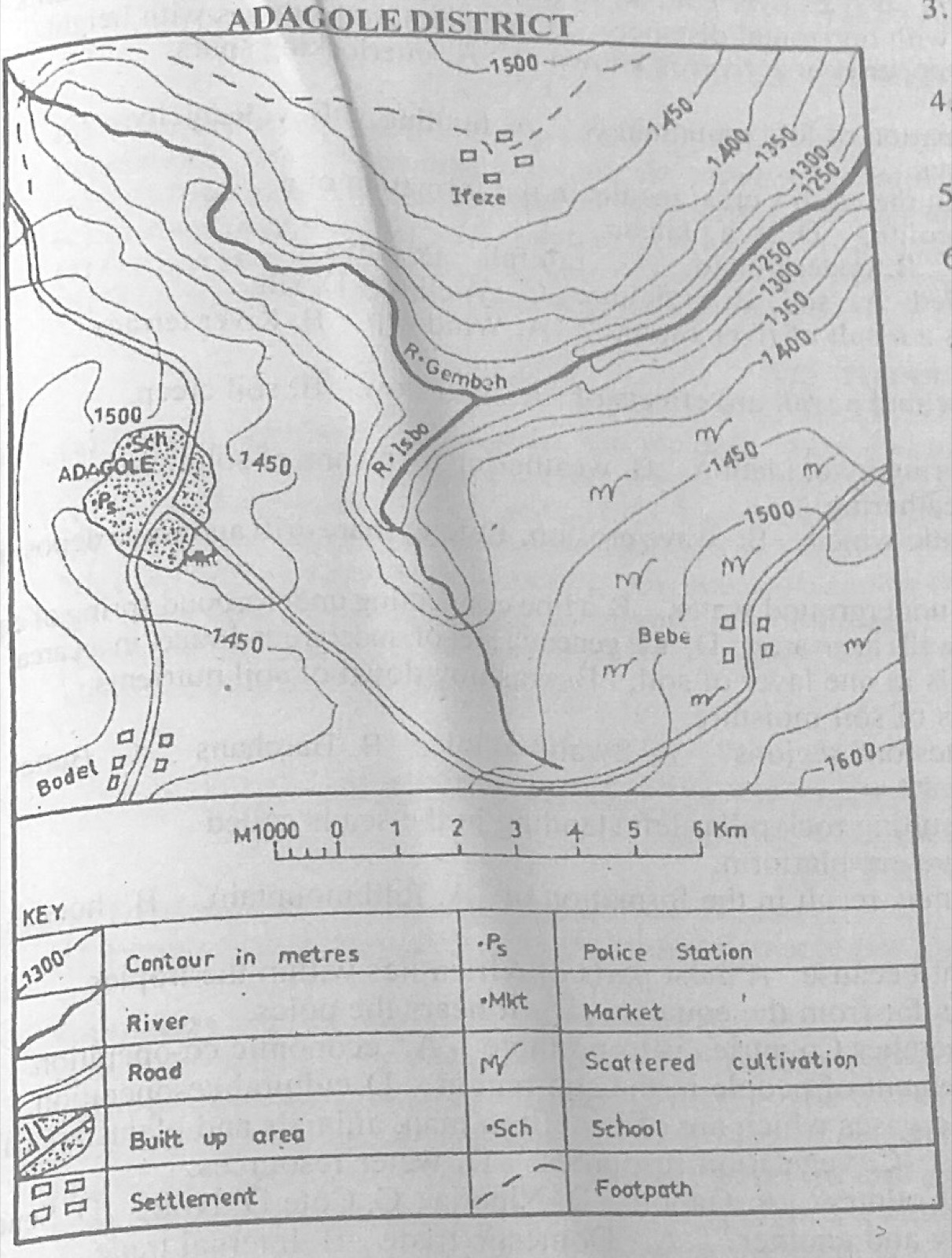
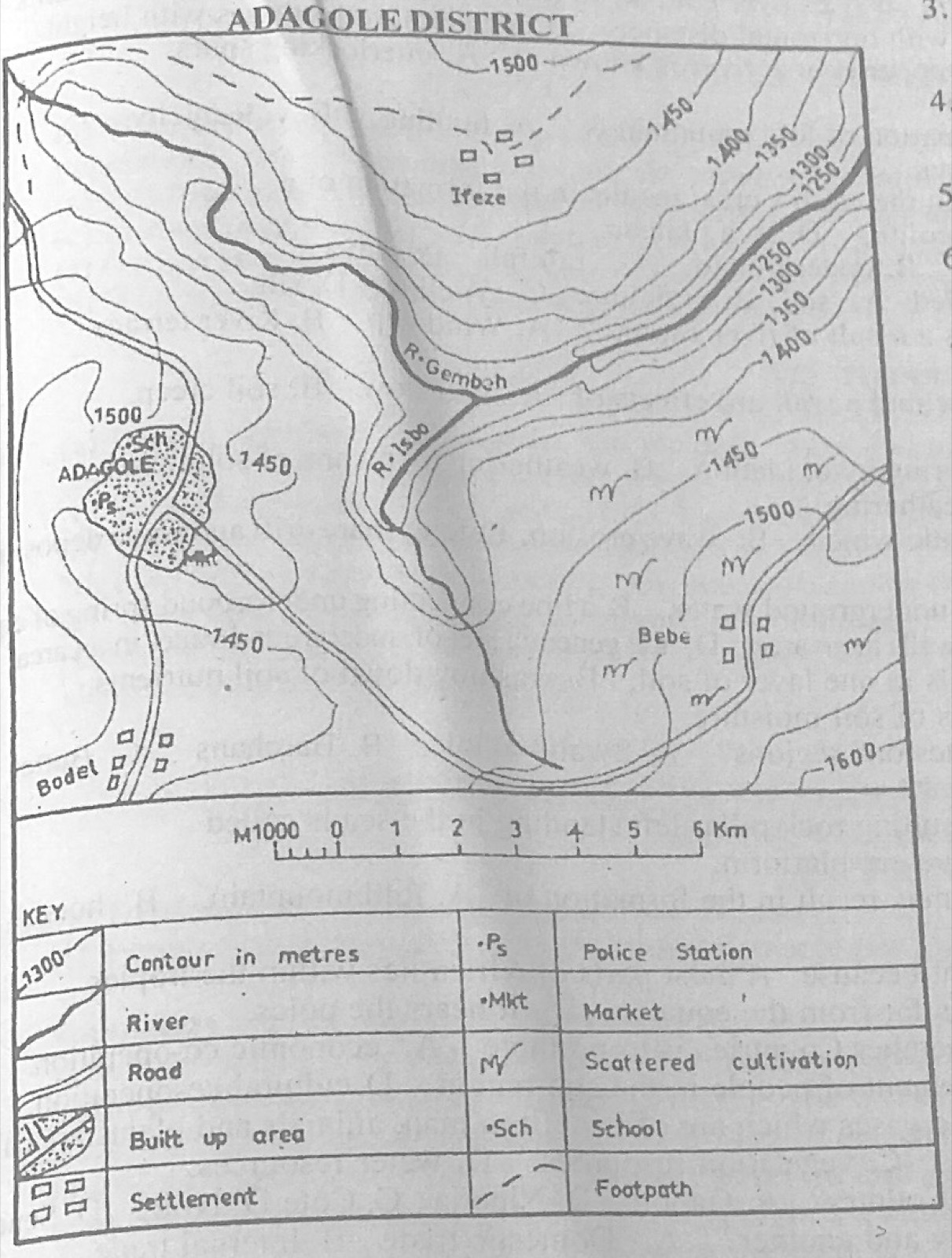
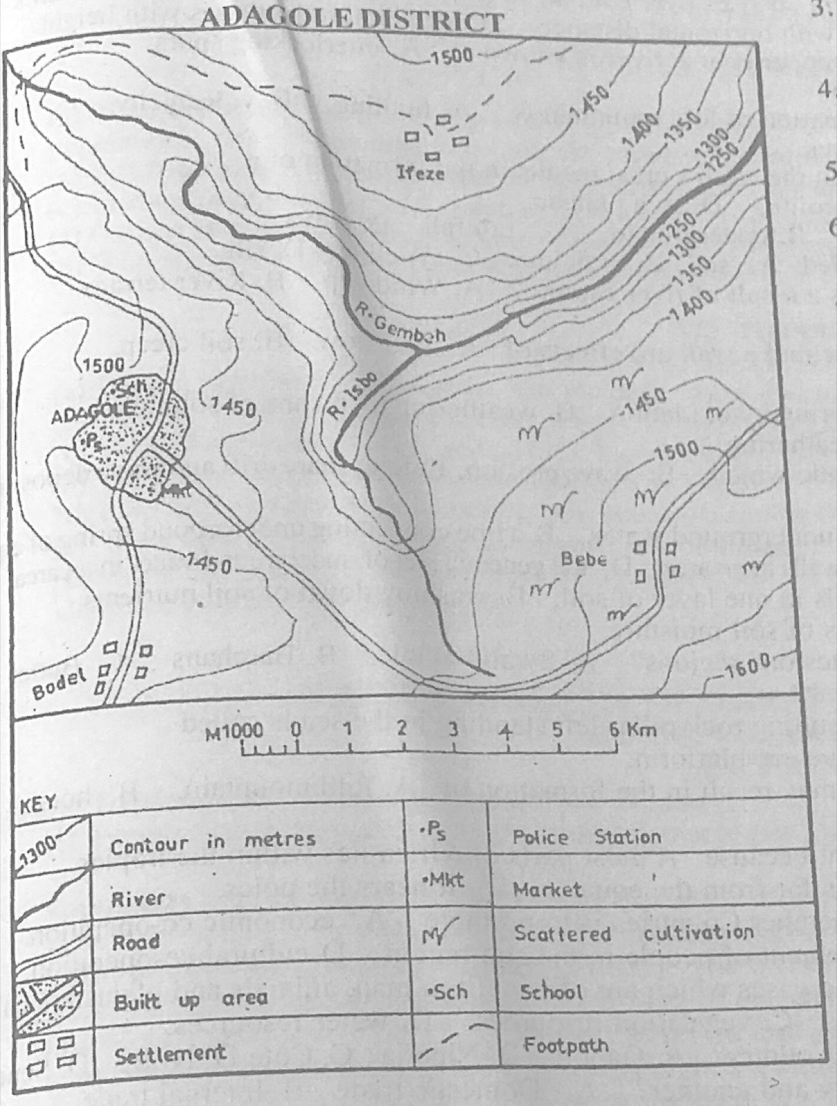
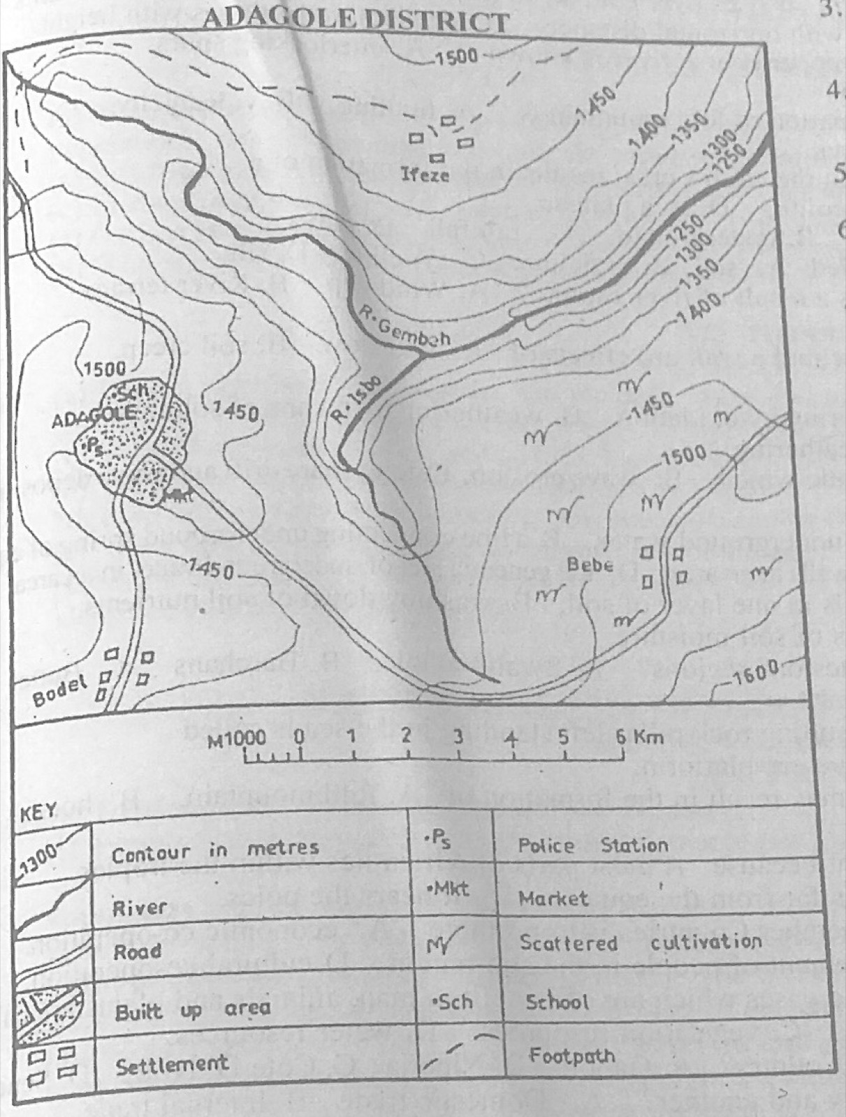
Study the map of ADAGOLE DISTRICT to answer this question. Farming is common in the

Diagram for this question
  1. A.north western part of the map.
  2. B.north eastern part of the map.
  3. C.south western part of the map.
  4. D.south eastern part of the map.
Show the answer and explanation

Answer: D (south eastern part of the map.)

Explanation

The scattered cultivation symbols are around Bebe, in the south-east.

Open this question

Question 4

Relief and Map Interpretation

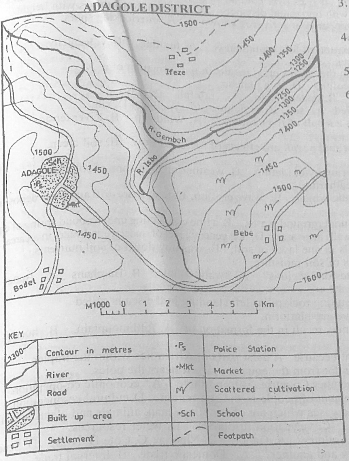
Study the map of ADAGOLE DISTRICT to answer this question. The point where R. Isbo meets R. Gembeh is called

Diagram for this question
  1. A.an entrepot.
  2. B.a watershed.
  3. C.a lagoon.
  4. D.a confluence.
Show the answer and explanation

Answer: D (a confluence.)

Explanation

The meeting point of two rivers is a confluence.

Open this question

Question 6

Relief and Map Interpretation

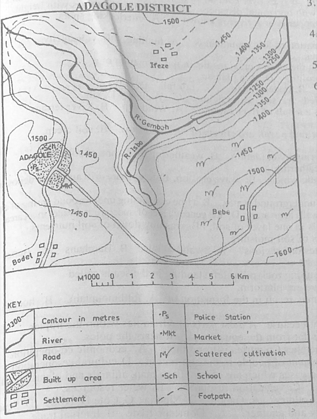
Study the map of ADAGOLE DISTRICT to answer this question. The lowest point in the mapped area is in the

Diagram for this question
  1. A.south-east.
  2. B.north-east.
  3. C.south-west.
  4. D.north-west.
Show the answer and explanation

Answer: B (north-east.)

Explanation

The 1250 m contours, the lowest on the map, are in the north-east where R. Gembeh leaves the map.

Open this question

Question 7

Map Scale, Distance and Direction

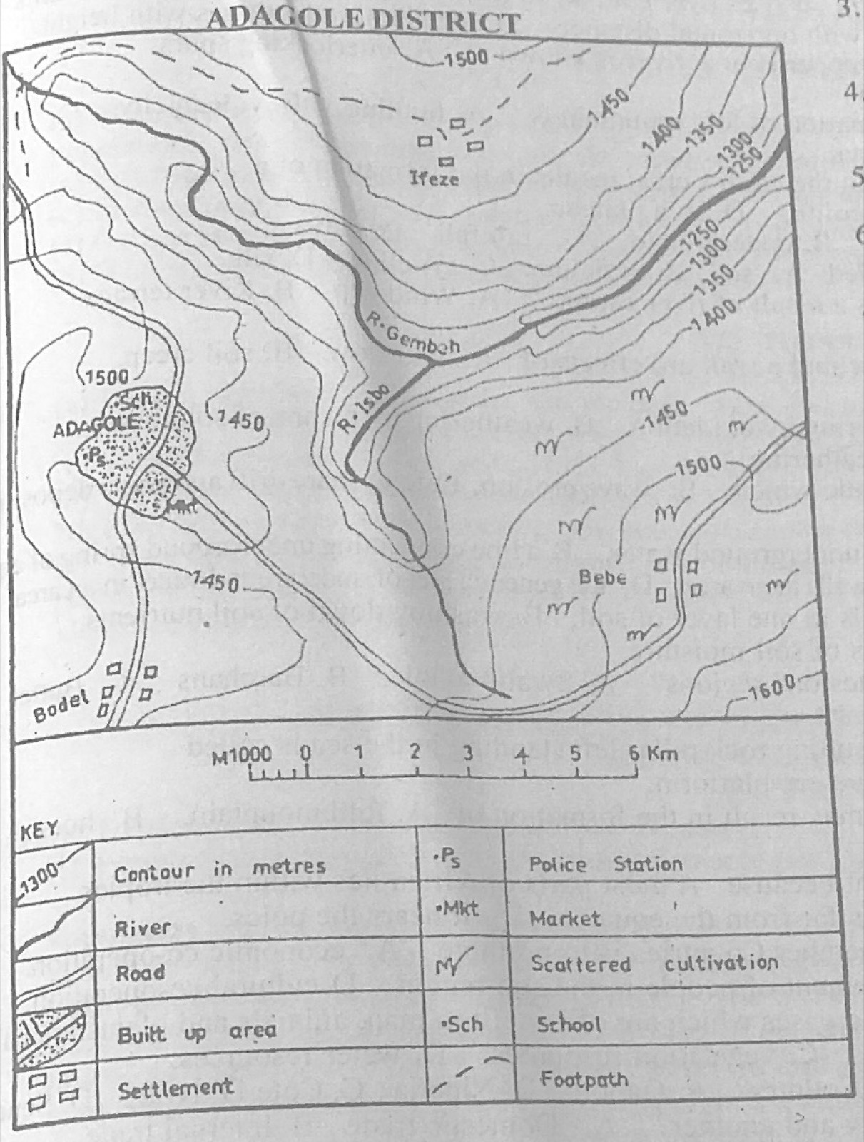
Study the map of ADAGOLE DISTRICT to answer this question. The distance as the crow flies from Bebe to Bodel is

Diagram for this question
  1. A.12.75 km.
  2. B.10.00 km.
  3. C.7.25 km.
  4. D.5.25 km.
Show the answer and explanation

Answer: B (10.00 km.)

Explanation

Measured with a ruler and compared with the linear scale, the straight line Bebe-Bodel is about 10 km.

Open this question

Question 8

Map Scale, Distance and Direction

Study the map of ADAGOLE DISTRICT to answer this question. The bearing of Bodel from Bebe is

Diagram for this question
  1. A.25.0°.
  2. B.255.0°.
  3. C.115.0°.
  4. D.150.0°.
Show the answer and explanation

Answer: B (255.0°.)

Explanation

Bodel lies west and a little south of Bebe, so its bearing is a little less than 270°: about 255°.

Open this question

Question 9

Relief and Map Interpretation

Study the map of ADAGOLE DISTRICT to answer this question. Which of the following statements is true about the drainage of the mapped area?

Diagram for this question
  1. A.The watershed from which the rivers take their sources is in the North West.
  2. B.R. Isbo and R. Gembeh are the two rivers that drain the district.
  3. C.R. Gembeh has many distributaries.
  4. D.An oxbow lake has been formed at the point of intersection of R. Isbo and R. Gembeh.
Show the answer and explanation

Answer: B (R. Isbo and R. Gembeh are the two rivers that drain the district.)

Explanation

Only two rivers, R. Isbo and R. Gembeh, are shown draining the district.

Open this question

Question 10

Relief and Map Interpretation

Study the map of ADAGOLE DISTRICT to answer this question. The common modes of transportation in the mapped area are

Diagram for this question
  1. A.railway and water.
  2. B.pipeline and railway.
  3. C.road and water.
  4. D.air and water.
Show the answer and explanation

Answer: C (road and water.)

Explanation

The map shows roads and rivers; there is no railway, pipeline or airport.

Open this question

Question 11

Statistical Maps and Diagrams

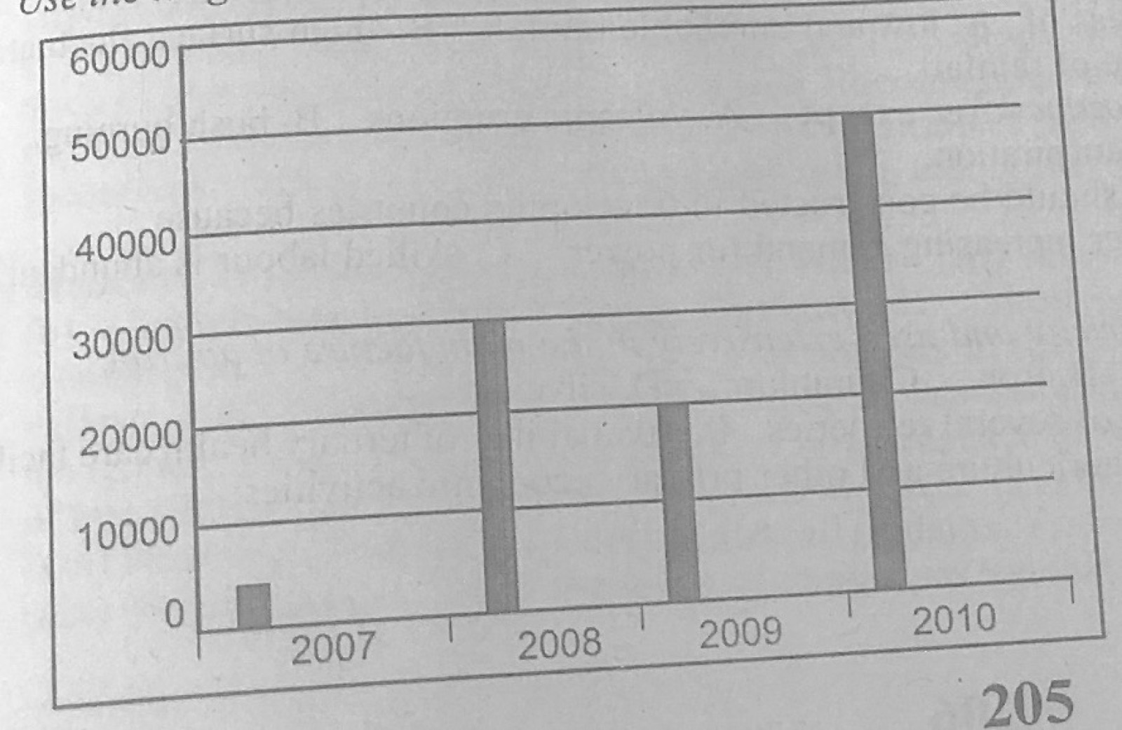
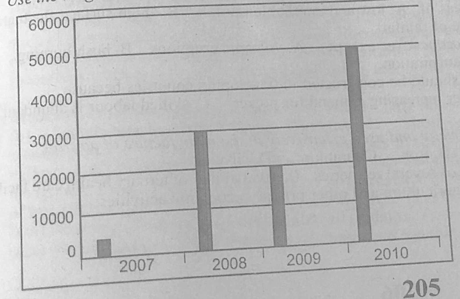
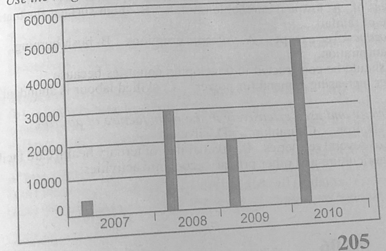
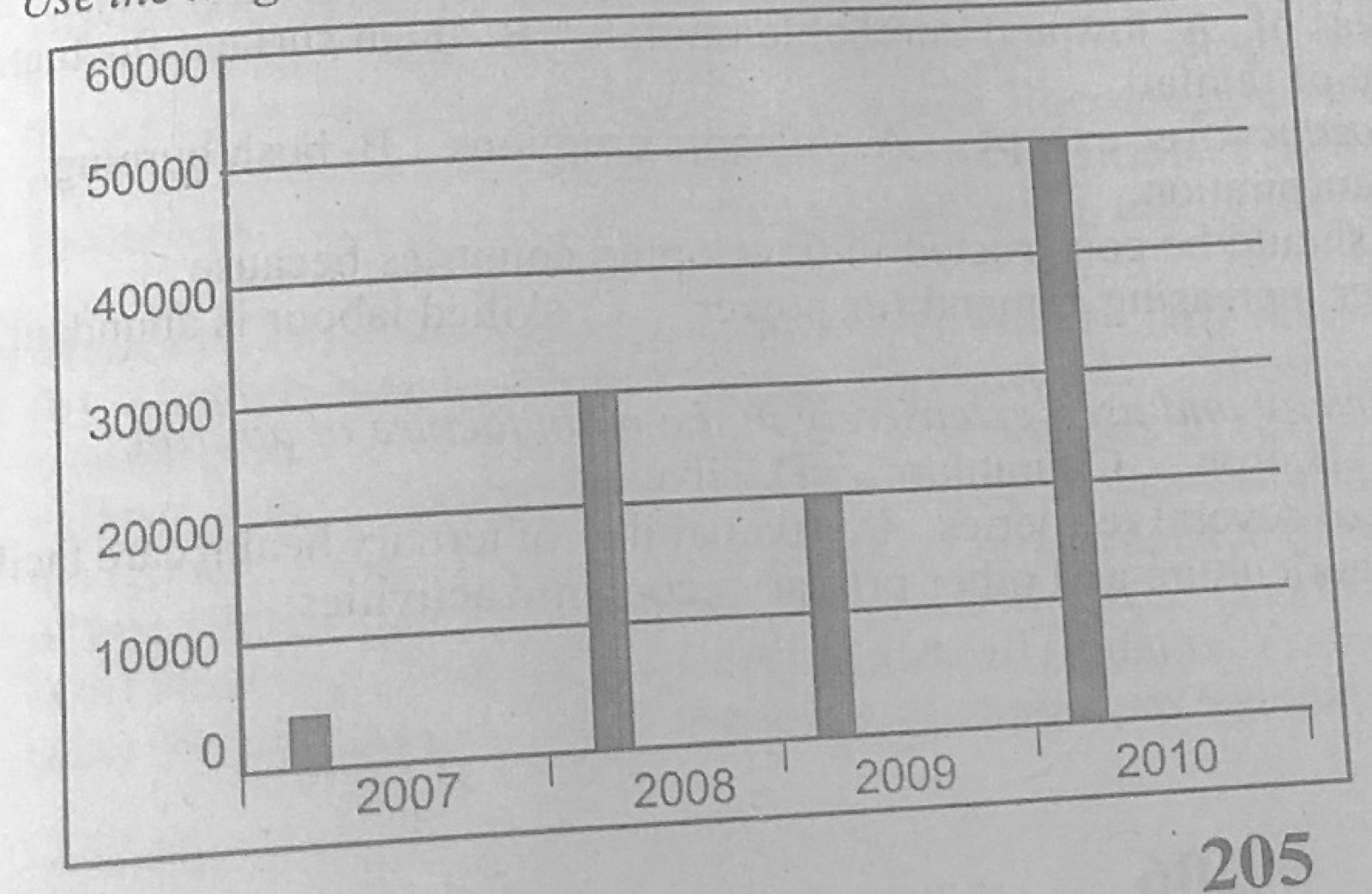
The diagram represents the export of rice in kilogrammes from Country X between 2007 and 2010. Use it to answer this question. What is the name of the diagram above?

Diagram for this question
  1. A.Line graph
  2. B.Bar graph
  3. C.Pie chart
  4. D.Star graph
Show the answer and explanation

Answer: B (Bar graph)

Explanation

Values are shown by the heights of separate bars.

Open this question

Question 12

Statistical Maps and Diagrams

The diagram represents the export of rice in kilogrammes from Country X between 2007 and 2010. Use it to answer this question. How much rice was produced in 2010 by Country X?

Diagram for this question
  1. A.10,000 kilogrammes.
  2. B.20,000 kilogrammes.
  3. C.50,000 kilogrammes.
  4. D.60,000 kilogrammes.
Show the answer and explanation

Answer: C (50,000 kilogrammes.)

Explanation

The 2010 bar reaches about the 50,000 line.

Open this question

Question 13

Statistical Maps and Diagrams

The diagram represents the export of rice in kilogrammes from Country X between 2007 and 2010. Use it to answer this question. The total production of rice in kilogrammes by Country X from 2007 to 2010 was

Diagram for this question
  1. A.60,000.
  2. B.105,000.
  3. C.200,000.
  4. D.260,000.
Show the answer and explanation

Answer: B (105,000.)

Explanation

About 5,000 + 30,000 + 20,000 + 50,000 = 105,000 kg.

Open this question

Question 14

Statistical Maps and Diagrams

The diagram represents the export of rice in kilogrammes from Country X between 2007 and 2010. Use it to answer this question. In which year did Country X have the highest production of rice?

Diagram for this question
  1. A.2007
  2. B.2008
  3. C.2009
  4. D.2010
Show the answer and explanation

Answer: D (2010)

Explanation

The 2010 bar is the tallest.

Open this question

Question 15

The Earth and Solar System

The planet which revolves around the sun in a clockwise direction is

  1. A.Jupiter.
  2. B.Mars.
  3. C.Saturn.
  4. D.Uranus.
Show the answer and explanation

Answer: D (Uranus.)

Explanation

Uranus is the planet usually given as turning the 'wrong' (clockwise) way; it spins on its side with retrograde rotation, unlike Jupiter, Mars and Saturn.

Open this question

Question 16

The Earth and Solar System

In the Southern hemisphere, the Summer Solstice falls on

  1. A.21st March.
  2. B.22nd December.
  3. C.23rd September.
  4. D.23rd June.
Show the answer and explanation

Answer: B (22nd December.)

Explanation

On 22 December the sun is overhead at the Tropic of Capricorn: midsummer in the Southern Hemisphere.

Open this question

Question 17

The Earth and Solar System

The planet with the shortest orbit around the sun is

  1. A.Jupiter.
  2. B.Mars.
  3. C.Mercury.
  4. D.Pluto.
Show the answer and explanation

Answer: C (Mercury.)

Explanation

Mercury is nearest the sun, so its orbit is the shortest (88 days).

Open this question

Question 18

Latitude, Longitude and Time

What will be the time in Sao Luis, Brazil (Longitude 45°w) when it is noon in London (longitude 0°)?

  1. A.10.00 pm.
  2. B.10.00 am.
  3. C.9.00 am.
  4. D.7.20 am.
Show the answer and explanation

Answer: C (9.00 am.)

Explanation

45° × 4 minutes = 180 minutes = 3 hours; west is behind, so 12 noon − 3 h = 9.00 am.

Open this question

Question 19

Weather

Isotherm is a line joining places of equal

  1. A.cloud cover.
  2. B.pressure.
  3. C.rainfall.
  4. D.temperature.
Show the answer and explanation

Answer: D (temperature.)

Explanation

Iso = equal, therm = heat: equal temperature.

Open this question

Question 20

Structure of the Earth

The ozone layer is found in the

  1. A.exosphere.
  2. B.ionosphere.
  3. C.stratosphere.
  4. D.troposphere.
Show the answer and explanation

Answer: C (stratosphere.)

Explanation

The ozone layer lies in the stratosphere, about 15-35 km up.

Open this question

Question 21

Latitude, Longitude and Time

Calculate the distance between the equator (latitude 0°) and a city Z in Egypt (latitude 30°N).

  1. A.2,300 km
  2. B.3,000 km
  3. C.3,330 km
  4. D.4,430 km
Show the answer and explanation

Answer: C (3,330 km)

Explanation

1° of latitude ≈ 111 km, so 30 × 111 = 3,330 km.

Open this question

Question 22

Climate

Which of the following climatic belts has the highest durnal temperature range?

  1. A.Desert
  2. B.Mediterranean
  3. C.Tropical Continental
  4. D.Tropical Hinterland
Show the answer and explanation

Answer: A (Desert)

Explanation

Clear skies and dry air make deserts very hot by day and cold at night.

Open this question

Question 23

Structure of the Earth

Which of the following gases is found in very little quantity in the atmosphere?

  1. A.Argon
  2. B.Carbon dioxide
  3. C.Nitrogen
  4. D.Oxygen
Show the answer and explanation

Answer: B (Carbon dioxide)

Explanation

Carbon dioxide makes up only about 0.04% of the air, less than argon (about 0.93%), oxygen (21%) or nitrogen (78%).

Open this question

Question 24

Weather

Temperature inversion occurs when

  1. A.warm air rises over cold air in the tropics.
  2. B.temperature remains the same with height.
  3. C.temperature increases with horizontal distance.
  4. D.temperature increases with height.
Show the answer and explanation

Answer: D (temperature increases with height.)

Explanation

Normally temperature falls with height; an inversion is when it rises with height.

Open this question

Question 25

Rivers and River Landforms

Circular depressions formed in the bed of an upper course river is known as

  1. A.interlocking spurs.
  2. B.plunge pools.
  3. C.rapids.
  4. D.potholes.
Show the answer and explanation

Answer: D (potholes.)

Explanation

Pebbles swirled by eddies drill round holes, potholes, in the river bed.

Open this question

Question 26

Earth Movements and Vulcanicity

The most satisfactory explanation for the formation of fold mountain is

  1. A.faulting.
  2. B.vulcanicity.
  3. C.compressional forces.
  4. D.tensional forces.
Show the answer and explanation

Answer: C (compressional forces.)

Explanation

Fold mountains form when compressional (squeezing) forces push rock layers into folds.

Open this question

Question 27

Earth Movements and Vulcanicity

The cooling and solidification of magma within the earth's crust results in the formation of a

  1. A.cinda cone.
  2. B.composite cone.
  3. C.laccolith.
  4. D.lava plateau.
Show the answer and explanation

Answer: C (laccolith.)

Explanation

A laccolith is an intrusive dome of magma cooled inside the crust; the others are extrusive.

Open this question

Question 28

Wind and Desert Landforms

In an oasis, water is derived from

  1. A.bajada.
  2. B.underground.
  3. C.rainfall.
  4. D.playa.
Show the answer and explanation

Answer: B (underground.)

Explanation

Oases occur where underground water reaches the desert surface.

Open this question

Question 30

Rivers and River Landforms

Which of the following features is produced as a result of river capture?

  1. A.Wind gap
  2. B.River terrace
  3. C.Gorge
  4. D.Incised meander
Show the answer and explanation

Answer: A (Wind gap)

Explanation

The beheaded river's dry valley through a ridge is left as a wind gap.

Open this question

Question 31

Weathering, Erosion and Mass Movement

Tilting of tree trunks, poles and piling of soil behind a wall are effects of

  1. A.mud flow.
  2. B.soil creep.
  3. C.rock slide.
  4. D.land slide.
Show the answer and explanation

Answer: B (soil creep.)

Explanation

Slow downhill movement of soil (soil creep) tilts poles and piles soil behind walls.

Open this question

Question 32

Weathering, Erosion and Mass Movement

Exfoliation of rock is as a result of

  1. A.weathering by oxidation.
  2. B.weathering by means of solution.
  3. C.mechanical weathering.
  4. D.biological weathering.
Show the answer and explanation

Answer: C (mechanical weathering.)

Explanation

Repeated heating and cooling makes outer rock layers peel off: mechanical weathering.

Open this question

Question 33

Coastal Landforms

Spits are formed by

  1. A.ocean currents and trade winds.
  2. B.wave erosion.
  3. C.long share drift and wave deposition.
  4. D.westerly winds.
Show the answer and explanation

Answer: C (long share drift and wave deposition.)

Explanation

Longshore drift carries sand along the coast and waves deposit it as a spit.

Open this question

Question 34

Underground Water and Karst

A water table can be described as

  1. A.a pool of underground water.
  2. B.a line connecting underground spring of equal height.
  3. C.a line indicating the depth of all artesian wells in an area.
  4. D.the general level of underground water in an area.
Show the answer and explanation

Answer: D (the general level of underground water in an area.)

Explanation

The water table is the upper level of the saturated zone underground.

Open this question

Question 35

Soils

Leaching is the

  1. A.accumulation of soil minerals in one layer of soil.
  2. B.washing down of soil nutrients.
  3. C.erosion of soil from steep slopes.
  4. D.loss of soil moisture.
Show the answer and explanation

Answer: B (washing down of soil nutrients.)

Explanation

Percolating water dissolves nutrients and carries them down out of the topsoil.

Open this question

Question 36

Underground Water and Karst

Which of the following features are found in limestone regions?

  1. A.Swallow holes
  2. B.Barchans
  3. C.Buttes
  4. D.Inselbergs
Show the answer and explanation

Answer: A (Swallow holes)

Explanation

Swallow holes are karst features; the others are desert features.

Open this question

Question 37

Coastal Landforms

When the roof of a natural arch collapses, the resulting rock pillar left standing in the sea is called

  1. A.headland.
  2. B.stack.
  3. C.tombolo.
  4. D.wave-cut platform.
Show the answer and explanation

Answer: B (stack.)

Explanation

The pillar left after an arch collapses is a stack.

Open this question

Question 38

Earth Movements and Vulcanicity

The high temperature in the interior of the earth may result in the formation of

  1. A.fold mountain.
  2. B.horst.
  3. C.geyser.
  4. D.rift valley.
Show the answer and explanation

Answer: C (geyser.)

Explanation

Underground heat boils groundwater, which spouts out as a geyser.

Open this question

Question 39

Geography of Africa

Africa is described as the most Tropical continent because

  1. A.most parts of Africa lies within the tropics.
  2. B.it lies astride the Greenwich meridian.
  3. C.it is far from the equator.
  4. D.it nears the poles.
Show the answer and explanation

Answer: A (most parts of Africa lies within the tropics.)

Explanation

Most of Africa lies between the Tropics of Cancer and Capricorn.

Open this question

Question 40

West Africa and ECOWAS

The introduction of ECOWAS Passport among member Countries is to promote

  1. A.economic co-operation.
  2. B.trade amongst member states.
  3. C.free movement of people in the sub-region.
  4. D.cultural co-operation.
Show the answer and explanation

Answer: C (free movement of people in the sub-region.)

Explanation

A common passport makes it easier for citizens to travel between member states.

Open this question

Question 41

Environmental Resources

Elements such as wind, water vapour, sunlight and gases which are of benefit to man, animals and plants are called

  1. A.human resources.
  2. B.atmospheric resources.
  3. C.vegetation resources.
  4. D.water resources.
Show the answer and explanation

Answer: B (atmospheric resources.)

Explanation

These are all parts of the atmosphere.

Open this question

Question 42

West Africa and ECOWAS

Which of the following is not a timber producing Country?

  1. A.Gabon
  2. B.Nigeria
  3. C.Cote D' Ivoire
  4. D.Senegal
Show the answer and explanation

Answer: D (Senegal)

Explanation

Senegal is mostly savanna and Sahel with little forest; Gabon, Nigeria and Côte d'Ivoire are major timber producers.

Open this question

Question 43

Transport, Trade and Tourism

What is the name of the trade between one country and another?

  1. A.Domestic trade
  2. B.Internal trade
  3. C.International trade
  4. D.Inter-state trade
Show the answer and explanation

Answer: C (International trade)

Explanation

Trade across national borders is international trade.

Open this question

Question 44

Settlement

Which of the following settlements is famous for its ecclesiastical function?

  1. A.Freetown
  2. B.London
  3. C.Lagos
  4. D.Rome
Show the answer and explanation

Answer: D (Rome)

Explanation

Rome contains the Vatican, centre of the Catholic Church.

Open this question

Question 45

Settlement

Which of the following cities is both a harbour and a capital?

  1. A.Accra
  2. B.Abidjan
  3. C.Banjul
  4. D.Abuja
Show the answer and explanation

Answer: C (Banjul)

Explanation

Banjul is the capital of The Gambia and its seaport.

Open this question

Question 46

Agriculture, Fishing and Lumbering

Irrigation projects are commonly found in areas of

  1. A.low and unreliable rainfall.
  2. B.high surface fluctuations.
  3. C.low rate of evaporation.
  4. D.high volume of rainfall.
Show the answer and explanation

Answer: A (low and unreliable rainfall.)

Explanation

Irrigation supplies water where rain is scarce or unreliable.

Open this question

Question 47

Environmental Hazards and Conservation

All the following lead to the depletion of the ozone layer except

  1. A.volcanic eruptions.
  2. B.bush burning.
  3. C.combustion of coal and oil.
  4. D.evapotranspiration.
Show the answer and explanation

Answer: D (evapotranspiration.)

Explanation

Evapotranspiration only releases water vapour; the others release gases that harm the ozone layer.

Open this question

Question 49

Mining and Energy

It is light in weight, a good conductor of electricity and used extensively in the manufacture of aircraft. This is a valid description of

  1. A.aluminium.
  2. B.iron.
  3. C.uranium.
  4. D.silver.
Show the answer and explanation

Answer: A (aluminium.)

Explanation

Aluminium is light, conducts electricity and is used for aircraft bodies.

Open this question

Question 50

Settlement

A village is characterized by

  1. A.the presence of several refineries.
  2. B.availability of tertiary health care facilities.
  3. C.developed infrastructural facilities.
  4. D.agriculture and other primary economic activities.
Show the answer and explanation

Answer: D (agriculture and other primary economic activities.)

Explanation

Villagers mostly farm, fish or do other primary activities.

Open this question

Theory question 101

Population

(a) Write explanatory notes on any two of the following: (i) Population density; (ii) Birth rate; (iii) Optimum population. (b) In what four ways can the problems of under population be solved?

Show the model answer
Model answer

(a)(i) Population density: number of people per unit area (total population ÷ total land area), e.g. persons per km²; high where resources are rich, low in deserts and forests.
(ii) Birth rate: number of live births per 1,000 people in a year; high in developing countries; used with the death rate to find natural increase.
(iii) Optimum population: the number of people that can make the best use of the available resources, giving the highest income per head; more people gives overpopulation, fewer gives underpopulation; it changes with technology.
(b) Encourage immigration of skilled people; incentives for large families (child allowances, free education and health care); pronatalist policies (discourage birth control); improve health care to cut deaths; develop and exploit resources with better technology; increase food supply and employment.

Explanation

Write two or three sentences on each chosen term.

Open this question

Theory question 102

Transport, Trade and Tourism

(a) List four modes of transportation. (b) Identify four constraints to inland water navigation. (c) In what four ways can the constraints identified in 2(b) above be solved?

Show the model answer
Model answer

(a) Road; rail; water; air; pipeline; cable/ropeway.
(b) Seasonal fluctuation of water level; rapids, waterfalls and cataracts; sandbars and silting; water weeds (water hyacinth); shallow rivers; tree stumps and rocks; lack of navigational aids; rivers flowing away from economic centres; low capital; competition from roads; piracy.
(c) Dredging and channelisation; building dams and locks to regulate water; clearing water weeds; installing navigational aids and lights; building canals round rapids; providing capital and modern vessels; good maintenance and port facilities; security patrols.

Explanation

Link each solution to a constraint.

Open this question

Theory question 103

Settlement

(a) Outline two characteristic features of each of the following: (i) Cornubation; (ii) Megapolis. (b) With specific examples, explain any six functions which settlements perform.

Show the model answer
Model answer

(a)(i) Conurbation: a large continuous built-up area formed when growing towns merge; has several centres; dense population; e.g. Lagos metropolis, Ruhr, Greater Manchester.
(ii) Megalopolis: a huge urban region formed by several conurbations joining; population of tens of millions; many functions; e.g. Boston-Washington (BosWash), Tokyo-Osaka.
(b) Administrative (Abuja, Accra); commercial (Lagos, Onitsha, Kano); industrial (Aba, Tema); mining (Jos, Enugu, Obuasi); port (Apapa, Takoradi); educational (Nsukka, Ile-Ife, Oxford); religious (Mecca, Rome, Jerusalem); residential (satellite towns); tourist/resort (Obudu, Miami); military (Kaduna); transport nodes (Lokoja, Kafanchan). Explain each with its example.

Explanation

Each function needs a named example.

Open this question

Theory question 104

Nigeria: People and Economy

(a) Draw a sketch map of Nigeria. On the map, show and name: (i) Rivers Niger and Benue; (ii) Kainji Dam; (iii) Abuja. (b) Explain three factors which favour the development of hydro-electric power projects in Nigeria. (c) State three economic benefits of the hydro-electric power projects.

Show the model answer
Model answer

(a) Map: River Niger entering from the north-west, flowing south-east to Lokoja and then south to the delta; River Benue entering from Cameroon in the east and joining the Niger at Lokoja; Kainji Dam on the Niger in Niger/Kwara area (north-west of Jebba); Abuja in the centre (FCT), north of the confluence.
(b) Large rivers with constant volume (Niger, Benue, Kaduna); falls and rapids and narrow valleys for dam sites (Kainji, Jebba, Shiroro); hard rock foundations; large demand for power from towns and industries; government finance and foreign aid; available land for reservoirs.
(c) Electricity for industries and homes; irrigation; fishing in reservoirs; improved navigation; flood control; tourism; employment; water supply.

Explanation

Explain why each factor helps HEP.

Open this question

Theory question 105

Manufacturing Industry

(a) State two advantages of industrialization in Nigeria. (b) Explain four problems that retard industrialization in Nigeria. (c) In four ways, describe how the problems in 5(b) above can be solved.

Show the model answer
Model answer

(a) Employment; foreign exchange earnings and savings; diversification of the economy; use of local raw materials; higher standard of living; technology transfer; revenue for government; infrastructure development.
(b) Inadequate and erratic power supply; shortage of capital and high interest rates; poor infrastructure (roads, water); shortage of local raw materials and spare parts; shortage of skilled labour; competition from cheap imports and smuggling; political instability and inconsistent policies; poor maintenance culture; low purchasing power.
(c) Improve and diversify power supply; provide loans at low interest and tax holidays; build roads, water and other infrastructure; develop local raw materials and spare-parts production; train manpower; ban or tax competing imports and control smuggling; consistent policies and stability; improve quality of local goods.

Explanation

Explain each problem in a sentence or two.

Open this question

Theory question 106

West Africa and ECOWAS

(a) State two objectives of the Economics Community of West African States (ECOWAS). (b) Identify four problems hindering the achievement of the objectives of ECOWAS. (c) In what four ways can the problems identified in 6(b) above be solved?

Show the model answer
Model answer

(a) Promote economic co-operation and integration; promote trade among members (remove tariffs, customs union); free movement of people, goods and services; develop transport and communication links; common currency; promote peace and security.
(b) Language differences; different currencies; political instability and different ideologies; poor transport and communication; non-payment of dues; strong colonial ties and rival blocs (e.g. UEMOA); similar products; fear of domination by bigger members; smuggling; cumbersome border controls.
(c) Improve transport and communication links; political stability and good governance; prompt payment of dues; common currency; teaching of English and French in schools; diversification of economies; implementation of agreed protocols; simpler travel documents and border controls; more commitment to ECOWAS.

Explanation

Pair each solution with a problem.

Open this question

Theory question 302

Statistical Maps and Diagrams

Use the data in the table below to answer the questions that follow: Country B's population figures (in millions) by State in the year 2005.
State A: 40
State B: 35
State C: 25
State D: 50
TOTAL: 150
(a) Construct a pie chart to represent the data. (b) Highlight any two problems in the use of pie charts. (c) State one other method that could be used to represent the above information.

Show the model answer
Model answer

(a) Angles = value ÷ 150 × 360°: A = 96°; B = 84°; C = 60°; D = 120° (total 360°). Draw a circle, measure each sector with a protractor from a vertical radius, shade or label each sector with state and value, add a key and title.
(b) Angles must be calculated, which takes time; small values give very thin sectors that are hard to draw and read; hard to compare sectors of similar size; actual values are not shown unless written; unsuitable for many components; absolute changes over time are hard to show.
(c) Simple bar graph; divided (component) bar graph; dot map or proportional symbols.

Explanation

Show the angle calculation for each state.

Open this question

Theory question 303

Rocks

(a) Highlight three differences between Plutonic and Volcanic rocks. (b) With the aid of diagrams, describe the mode of formation of crater lake.

Show the model answer
Model answer

(a) Plutonic rocks cool deep inside the crust, volcanic rocks cool on or near the surface; plutonic cool slowly and have large (coarse) crystals, volcanic cool fast and have small (fine) or no crystals; plutonic are exposed only after erosion, volcanic form at once on the surface; examples: granite, gabbro (plutonic) vs basalt, obsidian (volcanic); plutonic form batholiths, volcanic form lava plateaus and cones.
(b) A volcano erupts and builds a cone with a crater at the top; when activity stops, the vent is blocked by solidified lava; the crater (or a caldera formed when the summit collapses or is blown off) collects rain water, which cannot drain away, forming a crater lake, e.g. Lake Bosumtwi (Ghana), Crater Lake (Oregon), Lake Barombi. Diagrams: volcanic cone with crater; plugged vent with water in the crater.

Explanation

Name a real crater lake.

Open this question

Theory question 304

Underground Water and Karst

(a) State three characteristics of limestone region. (b) Describe the formation of limestone pillar. (c) In what two ways is limestone important to man?

Show the model answer
Model answer

(a) Little surface drainage (dry valleys, disappearing streams); swallow holes and sink holes; underground caves and streams; bare rocky surfaces with grikes and clints (limestone pavement); thin soils; springs at the base.
(b) Rain water containing carbon dioxide (weak carbonic acid) seeps through joints in the cave roof and dissolves calcium carbonate; drops hang from the roof and, as water evaporates and CO₂ escapes, calcite is deposited forming stalactites; drops falling on the floor build stalagmites; when a stalactite and stalagmite grow and join, a limestone pillar (column) is formed.
(c) Raw material for cement; building stone; flux in iron smelting; lime for agriculture and chemical industries; tourism (caves); groundwater sources.

Explanation

Explain both stalactite and stalagmite growth.

Open this question

Theory question 305

Environmental Resources

(a)(i) Highlight two ways in which water resources are classified. (ii) In what three ways can water resource be used? (b) Describe three ways by which man's activities limit the use of water as a resource.

Show the model answer
Model answer

(a)(i) Surface water (rivers, lakes, seas, oceans) and underground water (wells, springs, aquifers); also fresh water and salt water; atmospheric water (rain, water vapour).
(ii) Domestic use (drinking, cooking, washing); irrigation; industry (cooling, processing); HEP generation; transport; fishing; recreation and tourism.
(b) Pollution from industrial wastes, oil spills and sewage makes water unsafe; deforestation leads to silting and drying of rivers; over-pumping lowers the water table; building dams reduces flow downstream; dumping of refuse blocks channels; use of fertilisers and pesticides contaminates water; poor management causes waste.

Explanation

Explain how each activity reduces usable water.

Open this question

Theory question 306

Weather

(a) Define the term climate. (b) Name the instrument used in measuring each of the following climatic elements: (i) Temperature; (ii) Pressure; (iii) Rainfall; (iv) Sunshine; (v) Humidity. (c) In what four ways is the study of weather and climate important to man?

Show the model answer
Model answer

(a) Climate is the average weather conditions of a place over a long period, usually about 30-35 years.
(b)(i) Thermometer (maximum and minimum/Six's thermometer); (ii) barometer; (iii) rain gauge; (iv) Campbell-Stokes sunshine recorder; (v) hygrometer (wet and dry bulb thermometers).
(c) Helps farmers plan planting and harvesting; aviation and shipping safety; warns of hazards (storms, floods, drought); choice of clothing and building design; planning of tourism and sports; military operations; understanding of vegetation and soils.

Explanation

Learn one instrument for each element.

Open this question

Theory question 307

The Earth and Solar System

(a)(i) Define the term Solar System. (ii) List any five components of the Solar System. (b) Outline any four characteristics of the earth.

Show the model answer
Model answer

(a)(i) The solar system is the sun and all the heavenly bodies (planets, moons, asteroids, comets, meteors) that revolve round it under its gravity.
(ii) The sun; planets (Mercury, Venus, Earth, Mars, Jupiter, Saturn, Uranus, Neptune); moons/satellites; asteroids; comets; meteors and meteorites; dwarf planets (Pluto).
(b) Third planet from the sun (about 150 million km); spherical (oblate spheroid) shape, flattened at the poles; rotates on its axis in 24 hours; revolves round the sun in 365¼ days; axis tilted at 23½°; has one moon; has an atmosphere with oxygen and water, supporting life; equatorial circumference about 40,000 km.

Explanation

List planets in order from the sun.

Open this question

Theory question 308

Wind and Desert Landforms

(a) Outline three differences between deflation and abrasion. (b) Using specific examples, describe the mode of formation of a deflation hollow.

Show the model answer
Model answer

(a) Deflation is the removal (lifting and blowing away) of loose fine particles by wind, abrasion is the wearing of rock by sand carried in the wind (sand-blasting); deflation needs loose dry material, abrasion needs sand-laden wind hitting rock; deflation lowers the land surface creating hollows, abrasion carves rock features (rock pedestals, zeugen, yardangs); deflation works over wide areas, abrasion is mostly within about 1-2 m of the ground.
(b) Strong wind blows over loose, dry, unconsolidated sand and dust; fine particles are lifted and carried away (deflation); eddies deepen and widen the depression; the process continues until the water table is reached, where moisture binds the particles; the hollow may then hold water as an oasis or salt lake. Examples: Qattara Depression (Egypt), El Faiyum, depressions in the Kalahari and Sahara.
Explanation

Name a real deflation hollow.

Open this question