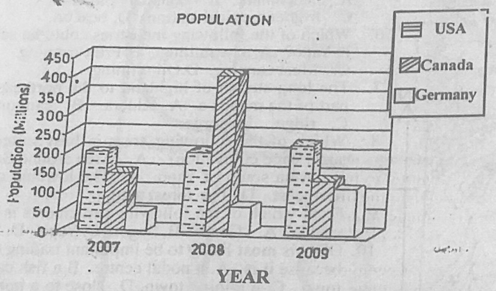
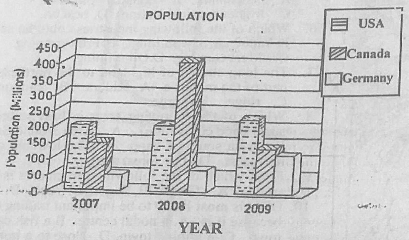
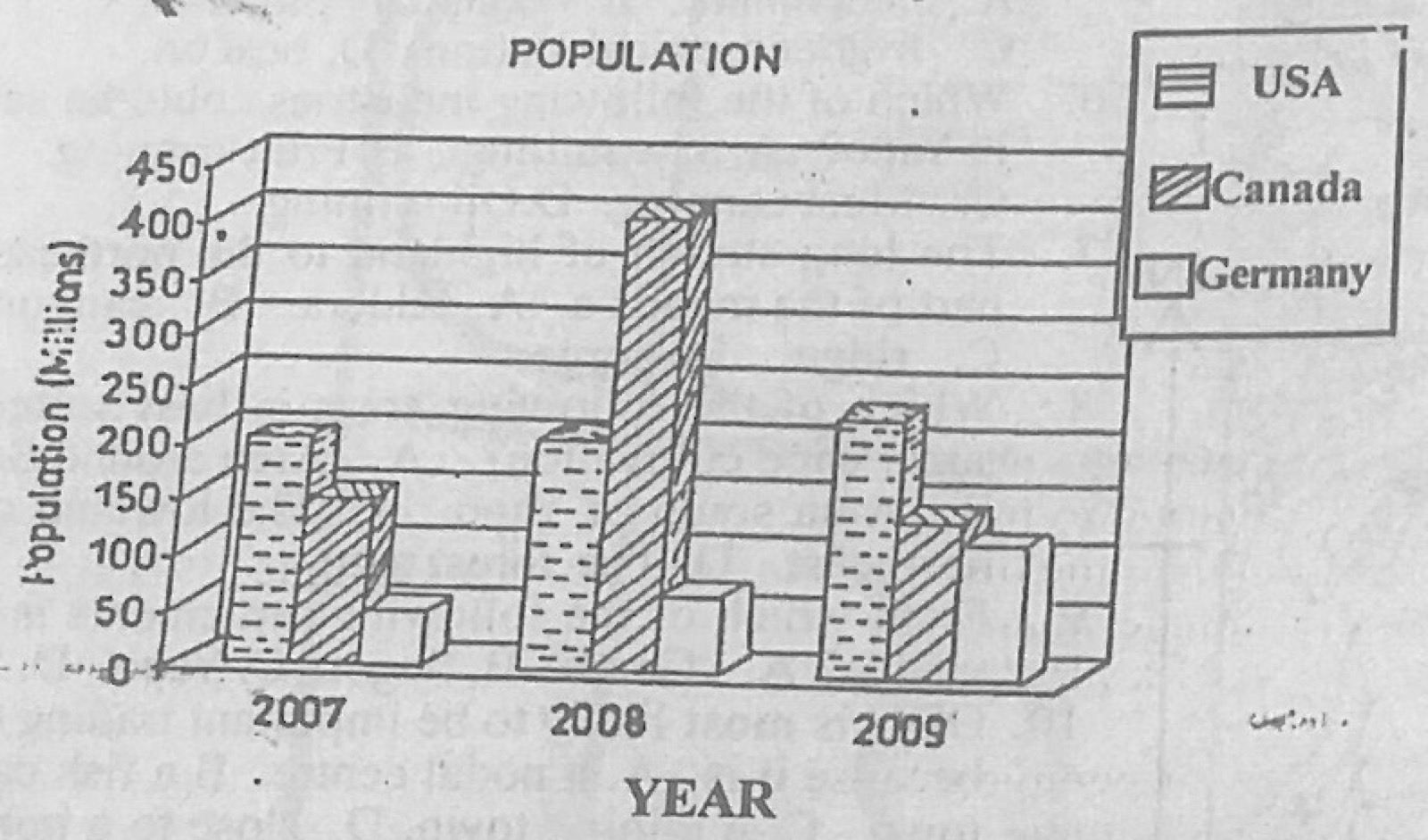
The diagram shows a hypothetical representation of population of selected countries (USA, Canada, Germany) in 2007, 2008 and 2009. Use it to answer this question. The diagrammatic representation above is a
A.Venn diagram.
B.line graph.
C.pie chart.
D.bar graph.
Show the answer and explanation
Answer: D (bar graph.)
Explanation
The values are shown by bars of different heights: a (multiple) bar graph.
The diagram shows a hypothetical representation of population of selected countries (USA, Canada, Germany) in 2007, 2008 and 2009. Use it to answer this question. The population of Canada in 2008 is
The diagram shows a hypothetical representation of population of selected countries (USA, Canada, Germany) in 2007, 2008 and 2009. Use it to answer this question. By how much did the population of Germany grow between 2008 and 2009?
A.10 million.
B.50 million.
C.120 million.
D.400 million.
Show the answer and explanation
Answer: B (50 million.)
Explanation
Read the Germany bars for 2008 and 2009 and subtract: the 2009 bar is about 50 million higher.
"The climate is constantly warm, rainfall is relatively abundant with double maxima, there is no month without rain." These are the characteristics of the
A.Monsoon climate.
B.Warm temperate climate.
C.Equatorial climate.
D.Mediterranean climate.
Show the answer and explanation
Answer: C (Equatorial climate.)
Explanation
Constant heat, rain in every month and two rainfall peaks describe the equatorial climate.
Through which of the following sea routes is crude oil from West Africa transported to European markets?
A.The Panama Canal route.
B.The Cape route.
C.The Suez Canal route.
D.The North Atlantic route.
Show the answer and explanation
Answer: B (The Cape route.)
Explanation
The Cape route links Western Europe with West Africa and goes on round the Cape of Good Hope. Tankers carrying crude oil from Nigeria and other West African countries to Europe use this route. The North Atlantic route joins Europe and North America.
(a) Outline four functions of an urban centre. (b) Highlight four problems of urbanization. (c) Suggest possible solutions to any two of the problems identified in (b) above.
Show the model answer
Model answer
(a) Administrative (government offices); commercial (markets, banks, shops); industrial; educational; health; residential; transport and communication centre; religious; recreational and tourism; provision of employment. (b) Traffic congestion; slums and housing shortage; unemployment; high crime rate; pollution and poor sanitation; pressure on amenities (water, power, schools); high cost of living; spread of diseases. (c) Congestion: more roads, mass transit, traffic control; slums: housing estates, urban renewal; unemployment: industries and skills training; crime: better security and jobs; pollution: waste management and sanitation laws; rural development to reduce migration.
(a) Highlight any three advantages of each of the following modes of transport: (i) Rail; (ii) Water. (b) Give any four reasons why some countries in Africa have not been able to sustain their rail transport.
Show the model answer
Model answer
(a)(i) Rail: carries bulky and heavy goods cheaply over long distances; carries many passengers at once; opens up new areas; no traffic congestion; safer than road; reliable timetables. (ii) Water: cheapest for bulky goods; carries very large loads; low construction cost (natural routes); links countries (international trade); good for heavy and non-perishable goods. (b) High cost of construction and maintenance; inadequate capital; poor management and corruption; competition from road transport; old narrow-gauge lines and engines; lack of spare parts and skilled staff; low freight and passenger traffic; depletion of the minerals the lines were built for; political instability and unstable policies.
(a) Define international trade. (b) Describe any five benefits of international trade. (c) What four factors limit trade between African countries and the United States of America (USA)?
Show the model answer
Model answer
(a) International trade is the exchange of goods and services between countries. (b) Countries obtain goods they cannot produce; earns foreign exchange; encourages specialisation; widens markets; government revenue from duties; transfer of technology and ideas; jobs; good international relations; raises living standards. (c) Distance and high freight costs; African exports are mostly raw materials of low value; strict US quality and health standards; tariffs and quotas; competition from other suppliers; low purchasing power in Africa; currency problems; political instability.
(a) Draw an outline map of Nigeria. On it, locate and name: (i) The Chad Basin; (ii) The Western Highlands; (iii) One important town in 5(a)(i) or (ii) above. (b) Describe the geography of the Western Highlands under the following headings: (i) Relief; (ii) Economic activities; (iii) Problems of development.
Show the model answer
Model answer
(a) Map: Chad Basin in the north-east (Maiduguri); Western Highlands in the south-west/west (Oyo, Osun, Ekiti, Kwara; towns such as Oyo, Ilorin, Ado-Ekiti, Iseyin). (b)(i) Relief: undulating upland of crystalline basement rock, 300-600 m, rising above 600 m in the Ekiti and Idanre hills; inselbergs (e.g. Olumo Rock, Idanre); dissected by rivers (Ogun, Osun, Oyo) flowing south. (ii) Economic activities: cocoa, kola and oil palm farming in the south; yams, maize, cassava and tobacco; cattle in drier north; lumbering; quarrying and mining (granite, kaolin, gold at Ilesha); trade and crafts (weaving, dyeing); tourism. (iii) Problems: soil erosion and leaching; rugged terrain for roads; bush burning; ageing cocoa farms and pests; rural-urban migration; poor roads and amenities; insufficient capital.
(a) Explain any five physical factors that hinder the development of railway transportation in Nigeria. (b) Highlight any five ways transportation contributes to the economic development of Nigeria.
Show the model answer
Model answer
(a) Rugged relief and steep gradients (Jos Plateau, Udi hills, eastern highlands); many rivers and wide floodplains needing costly bridges (Niger, Benue); swamps and creeks in the south (Niger Delta); dense rainforest; heavy rainfall causing washouts and erosion; sandy desert soils and dust in the far north; floods. (b) Movement of goods and raw materials; movement of people and labour; links producing areas with markets and ports; opens up new areas; promotes trade (internal and international); employment; national unity; tourism; government revenue; growth of towns.
(a) Explain any five factors that are responsible for the population distribution in West Africa. (b) Outline any five advantages of low population density in some parts of West Africa.
Show the model answer
Model answer
(a) Climate (more people where rainfall is adequate; few in the Sahara/Sahel); fertile soils; relief (few in rugged highlands, many on plains and plateaus such as Jos); water supply; minerals (Jos, Tarkwa, Port Harcourt); industrialisation and employment in towns; historical factors (slave raids depopulated the middle belt; old kingdoms like Kano, Ife); pests and diseases (tsetse, river blindness); transport; government policy and capitals. (b) Plenty of land for farming and grazing; less pressure on amenities; less pollution and congestion; lower crime; less environmental degradation; room for future development; fallowing restores soil fertility; resources conserved; lower cost of land.
(a) Draw an outline map of Africa. On the map, show and name: (i) Any three rivers important for generating electricity; (ii) Any two dams on two of the rivers. (b) Outline any five benefits of hydroelectric power to the people of Africa.
Show the model answer
Model answer
(a) Map with rivers such as Niger (Kainji, Jebba), Volta (Akosombo), Nile (Aswan High Dam), Zambezi (Kariba, Cahora Bassa), Congo (Inga); dams drawn on the correct rivers. (b) Cheap, clean and renewable electricity; power for industries (e.g. aluminium smelting at Tema); domestic lighting and appliances; rural electrification; reservoirs for irrigation, fishing and transport; flood control; employment; tourism; export of electricity earns foreign exchange; reduces use of firewood.
(a) Draw a sketch map of Africa. On the map, locate and name any two areas of gold mining in South Africa. (b) Describe one method of mining gold in South Africa. (c) State any four importance of gold mining to South Africa.
Show the model answer
Model answer
(a) Map: Witwatersrand (Johannesburg), Orange Free State goldfield (Welkom), Klerksdorp, Evander, Barberton. (b) Shaft (deep) mining: vertical shafts are sunk to great depths (over 3,000 m); horizontal tunnels (drifts/stopes) follow the gold-bearing reef; the ore is blasted, loaded into wagons and lifted to the surface; it is crushed into fine powder and gold is extracted by cyanide or mercury and smelted into bars. (Alternatively alluvial panning or open cast.) (c) Foreign exchange; government revenue; employment for millions including migrant workers; growth of towns (Johannesburg); development of transport and industries; attracts foreign investment; raw material for jewellery and electronics.
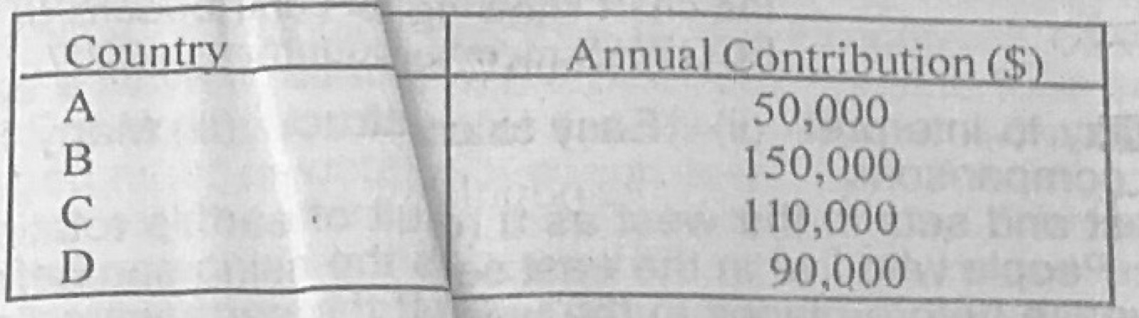
Four Economic Community of West African States (ECOWAS) member countries contributed to a capital project in the sub-region in 2007 as shown below: Country A: $50,000 Country B: $150,000 Country C: $110,000 Country D: $90,000 (a) Illustrate the information above in a pie chart. (b) State two advantages of using pie chart.
Show the model answer
Model answer
(a) Total = $400,000. Angles: A = 50,000/400,000 × 360° = 45°; B = 135°; C = 99°; D = 81° (sum 360°). Draw a circle of suitable radius, measure the sectors with a protractor from a vertical radius, shade/label each country with its value or percentage (A 12.5%, B 37.5%, C 27.5%, D 22.5%), title and key. (b) Simple and attractive; easy to compare each part with the whole; easy to understand at a glance; shows many items in one diagram; easy to construct.
(a) With the aid of diagrams, explain the following terms in relation to the shape of the earth. (i) Sunrise and sunset. (ii) Circumnavigation. (b) Calculate the distance between town A (latitude 5°N) and town B (latitude 10°N) if they are both situated on the same meridian.
Show the model answer
Model answer
(a)(i) Because the earth is a sphere rotating from west to east, the sun rises earlier at places to the east and later at places to the west; sunrise and sunset happen at different times along different longitudes; if the earth were flat the sun would rise at the same time everywhere. Diagram of a globe lit from one side. (ii) Circumnavigation: travelling continuously in one direction (e.g. eastwards) round the earth brings the traveller back to the starting point, as Magellan's expedition did; this is possible only on a sphere. Diagram of a route round a globe. (b) Both are north of the Equator: 10° − 5° = 5°; 5 × 111 km = 555 km (5 × 69 miles = 345 miles).
Explanation
Subtract latitudes when both places are in the same hemisphere.
(a) With the aid of diagrams, describe one mode of formation of a block mountain. (b) In what four ways are mountains of economic importance?
Show the model answer
Model answer
(a) Tension (or compression) in the crust produces two parallel faults; either the land between the faults is pushed up, or the land on both sides sinks, leaving the middle block standing high as a block mountain (horst) with steep fault-scarp sides and a flat top; e.g. Vosges, Black Forest, Ruwenzori, Usambara. Diagrams showing the faults, the arrows of movement and the raised block. (b) Source of minerals; tourism and recreation (mountaineering, cool resorts); hydro-electric power from fast rivers; source of rivers; grazing (transhumance); forests and timber; relief rainfall on windward slopes; climatic barriers and defence; cool climate for crops such as tea and temperate vegetables.
(a) Define the term weathering. (b) Describe four processes of chemical weathering.
Show the model answer
Model answer
(a) Weathering is the breaking down or decay of rocks in their original place (in situ) by physical, chemical and biological processes, without the material being carried away. (b) Carbonation: rainwater with carbon dioxide forms weak carbonic acid that dissolves limestone; oxidation: oxygen in water combines with iron in rocks, forming rust-coloured iron oxide that crumbles; hydration: minerals absorb water, swell and break up (e.g. feldspar to kaolin); hydrolysis: water reacts chemically with minerals such as feldspar in granite to form clay; solution: soluble minerals such as rock salt dissolve directly in water.
Explanation
Name the rock or mineral affected by each process.
(a) List any two types of delta. (b) Explain four conditions favourable for the formation of delta. (c) Describe three main characteristics of a delta.
Show the model answer
Model answer
(a) Arcuate (fan-shaped), e.g. Niger, Nile; bird's-foot, e.g. Mississippi; estuarine/cuspate, e.g. Tiber. (b) The river carries a large load of sediment; the sea or lake at the mouth is calm, with weak tides and currents; shallow, gently sloping sea floor; no strong currents to carry sediment away; slow speed of the river at its mouth; salt water helps the clay particles to flocculate and settle. (c) Low, flat land of fine alluvium; the river splits into many distributaries; swamps, lagoons and creeks; fertile soils; builds out into the sea; mangrove vegetation in the tropics; triangular or fan shape.
Write explanatory notes on flooding under the following: (a) areas of occurrence; (b) causes; (c) negative effects; (d) control.
Show the model answer
Model answer
Flooding is the covering of normally dry land by water. (a) River floodplains and valleys (Niger, Benue, Nile, Mississippi); deltas and coastal lowlands (Niger Delta, Lagos, Bangladesh); low-lying parts of towns with poor drainage; areas below dams. (b) Heavy and prolonged rainfall; overflowing rivers; release of water from dams; blocked drainage and building on waterways; deforestation increasing runoff; storm surges and high tides; melting snow; dam failure. (c) Loss of lives; destruction of homes, roads and bridges; crops and livestock destroyed; displacement of people; water-borne diseases; soil erosion; economic losses. (d) Build dams and reservoirs; levees and embankments; dredging and channelisation; good drainage and clearing of gutters; afforestation; control of building on floodplains; early warning; planned release of dam water.
(a) Define ecosystem. (b) Describe any four ways in which man has interfered with the ecosystem. (c) With specific examples, outline three effects of man's interference with the ecosystem.
Show the model answer
Model answer
(a) An ecosystem is a community of plants and animals interacting with one another and with their non-living environment (soil, water, air, sunlight) in an area. (b) Deforestation (lumbering, farming, urbanisation); bush burning; mining and quarrying; pollution of air, water and land; overgrazing; hunting and fishing; building of dams; use of fertilisers and pesticides; urbanisation and road building. (c) Soil erosion and gullies (e.g. Agulu-Nanka, Anambra); desertification in northern Nigeria; loss of wildlife and plant species (extinction); oil pollution killing fish in the Niger Delta; global warming and climate change; flooding; acid rain; loss of soil fertility.