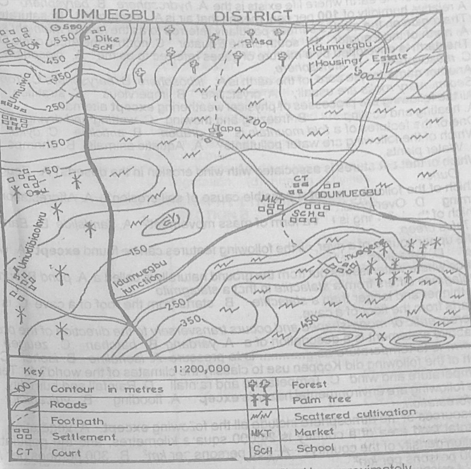
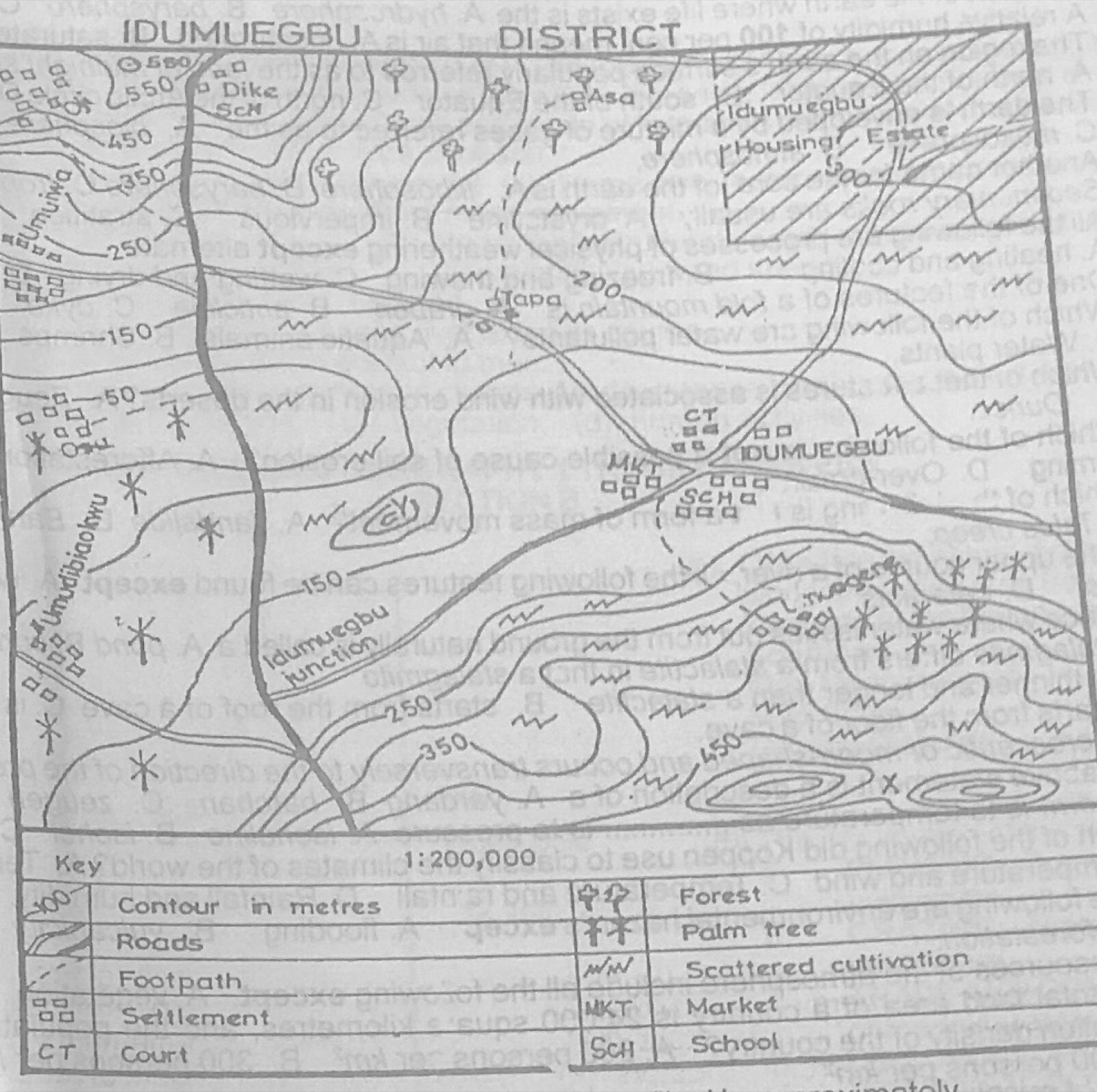
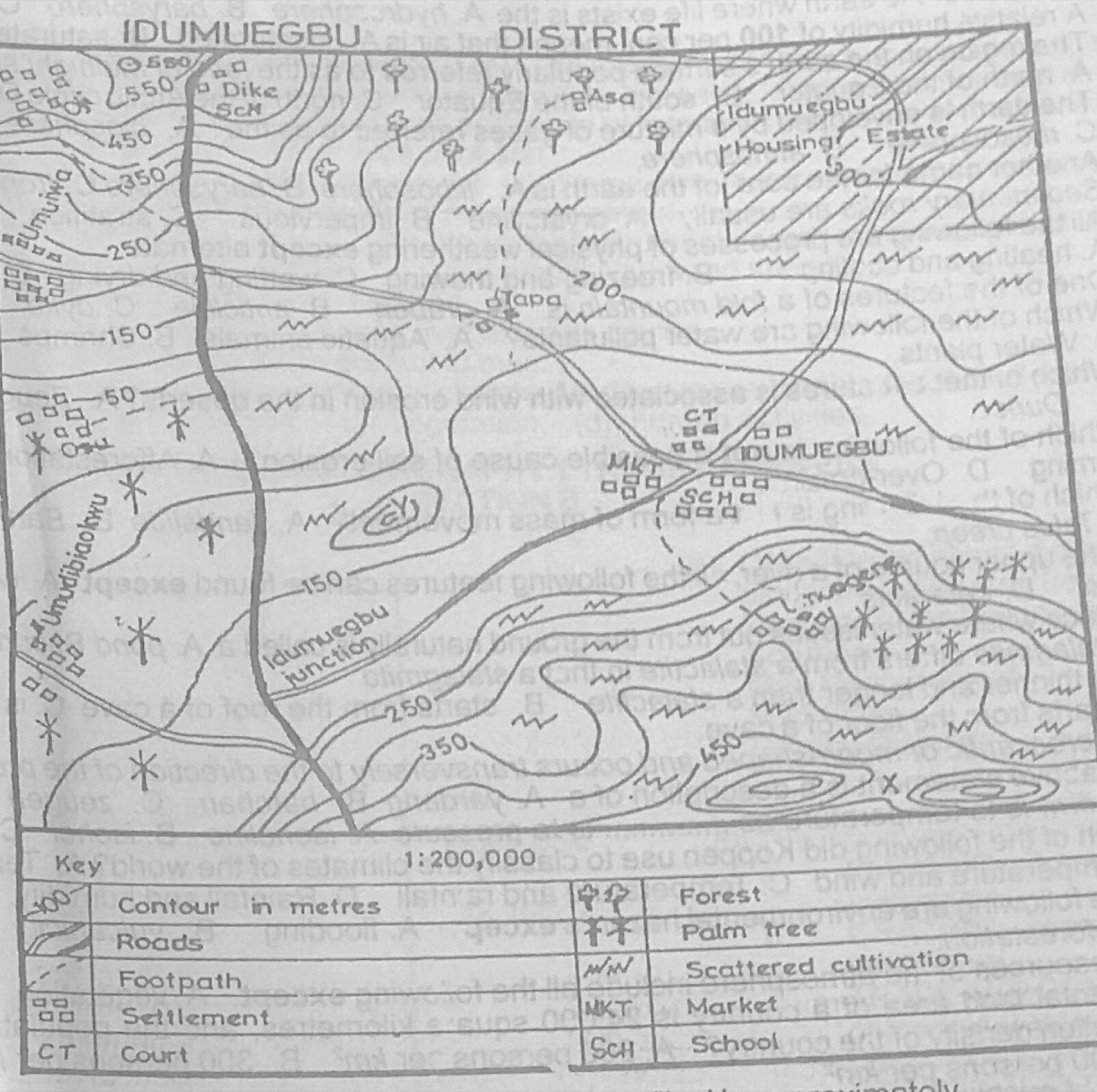
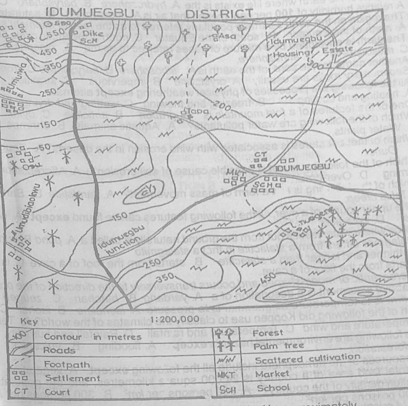
Study the map of IDUMUEGBU DISTRICT to answer this question. The highest contour line on the map is
A.500 m
B.600 m
C.650 m
D.700 m.
Show the answer and explanation
Answer: C (650 m)
Explanation
The contour labels on the map are 50, 150, 250, 350, 450 and 550 m, so every contour ends in 50. On the hills in the south-east, the rings inside the 450 m line go up to at least 650 m, so the highest contour among the options is 650 m.
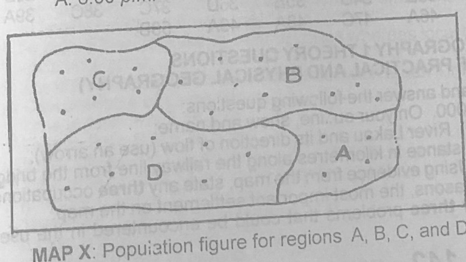
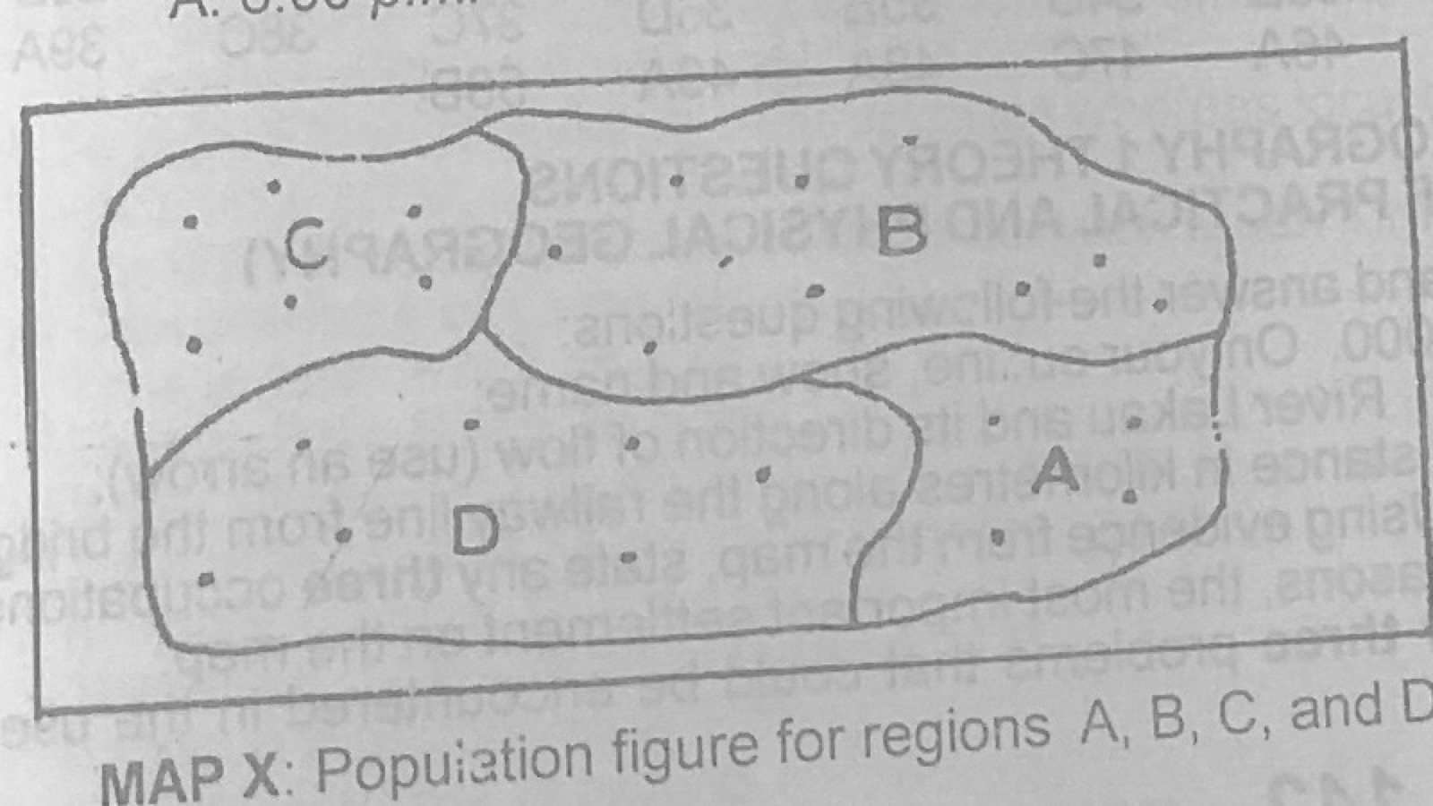
Map X shows the population of regions A, B, C and D (1 dot represents 10,000 persons). Use it to answer this question. What is the total population of Region A?
A.10,000
B.15,000
C.40,000
D.45,000.
Show the answer and explanation
Answer: C (40,000)
Explanation
Count the dots in region A (four) and multiply by 10,000.
Map X shows the population of regions A, B, C and D (1 dot represents 10,000 persons). Use it to answer this question. What is the total population of Regions B and C?
A.100,000
B.150,000
C.160,000
D.200,000.
Show the answer and explanation
Answer: C (160,000)
Explanation
Count the dots in B and C together and multiply by 10,000.
Map X shows the population of regions A, B, C and D (1 dot represents 10,000 persons). Use it to answer this question. What type of statistical method was used to represent the population in map X above?
A.Histogram
B.Pie chart
C.Proportional circle
D.Dot map.
Show the answer and explanation
Answer: D (Dot map.)
Explanation
Each dot stands for a fixed number of people, so it is a dot map.
Which of the following is not a major type of migration?
A.Rural – urban
B.International
C.Inter-community
D.Urban-rural.
Show the answer and explanation
Answer: C (Inter-community)
Explanation
The main types of migration are rural-urban, urban-rural, and internal or international; inter-community movement is not usually listed as a major type.
(a) Name two light industries and two heavy industries (b) Outline four factors which an industrialist must consider before locating an industry in a particular place (c) Highlight four contributions of manufacturing industries to the economy of any country.
Show the model answer
Model answer
(a) Light: food processing, textiles, printing, pharmaceuticals, soft drinks, leather goods. Heavy: iron and steel, shipbuilding, cement, petroleum refining, motor assembly, aluminium smelting. (b) Nearness to raw materials; labour (skilled and unskilled); power supply; market; transport; capital; water supply; government policy; political stability; land. (c) Employment; government revenue; foreign exchange earnings and savings; diversification of the economy; transfer of technology; growth of towns and infrastructure; higher standard of living; goods for local use.
(a) State four advantages of rural–urban migration (b) Describe four effects of rural–urban migration on the urban areas (c) Highlight two measures that can be taken to stop rural–urban migration.
Show the model answer
Model answer
(a) Provides labour for urban industries and services; reduces pressure on rural farmland; migrants earn more and send money home; spread of ideas and skills when migrants return; growth of towns and commerce; better access to education and health for migrants. (b) Overcrowding, housing shortage and slums; unemployment and underemployment; crime and social vices; traffic congestion; pressure on water, power, schools and hospitals; pollution and poor sanitation; high cost of living. (c) Develop rural areas with amenities (electricity, water, roads, schools, hospitals); site industries and higher institutions in rural areas; create jobs and farm settlements; give loans and incentives to farmers; set up cooperatives.
For candidates in Nigeria: (a) Outline any five factors that contribute to the development of tourism in Nigeria. (b) Highlight any five contributions of the tourist industry to the economic development of Nigeria.
Show the model answer
Model answer
(a) Attractive scenery: waterfalls, hills, plateaux (Obudu, Jos, Erin-Ijesha, Olumo Rock); beaches (Bar Beach, Lekki, Eleko); game reserves and wildlife (Yankari, Kainji); cultural heritage and festivals (Argungu, Durbar, Osun-Osogbo, Calabar Carnival); historical sites and museums; favourable climate; good transport and hotels; publicity and government support; security. (b) Foreign exchange; employment (hotels, guides, transport); revenue to government; growth of infrastructure; market for local crafts; promotes culture and international understanding; development of related industries; income for local communities.
For candidates in Nigeria: (a) In what four ways has the physical setting of the Sokoto plains of Nigeria influenced the types of economic activities in the region? (b) Highlight any four problems of development facing this region. (c) Outline two ways in which any of the problems in 5(b) above could be solved.
Show the model answer
Model answer
(a) Flat to gently undulating plains make farming and grazing easy; low, seasonal rainfall and long dry season favour drought-tolerant crops (millet, sorghum, groundnut, cotton) and cattle, sheep and goat rearing; the Sokoto-Rima river and fadama flood plains support irrigated rice, onions, wheat and vegetables and fishing (Argungu); sedimentary rocks provide limestone for cement (Sokoto) and phosphate/kaolin; tsetse-free savanna supports pastoralism and hides and skins trade. (b) Low and unreliable rainfall and drought; desertification and sand dunes; poor sandy soils; shortage of water; long distance from the sea and poor transport; few industries and low investment; seasonal flooding of rivers; poverty and low literacy. (c) Irrigation schemes and dams (Bakolori, Goronyo); afforestation and shelter belts; improved roads and railways; boreholes and water supply; provide credit and incentives for industries; fertilizers and improved seeds.
Explanation
Link each activity to relief, climate, rivers or rocks.
For candidates in Nigeria: (a) Draw an outline map of Nigeria. On the map show and name: (i) the railway line from Lagos to Minna; (ii) one area each of limestone; coal; columbite; gold. (b) Describe the method of mining columbite in Nigeria. (c) Highlight three adverse effects of mining in one of the mining areas in 6(a)(ii) above.
Show the model answer
Model answer
(a) Railway Lagos-Abeokuta-Ibadan-Oshogbo-Ilorin-Jebba-Mokwa-Minna; limestone: Ewekoro, Nkalagu, Sokoto, Ukpilla; coal: Enugu (Udi), Okaba, Gombe; columbite: Jos Plateau (Jos, Bukuru); gold: Maru, Bin Yauri, Iperindo/Ilesha. (b) Columbite occurs with tin ore in alluvial deposits on the Jos Plateau; overburden removed by draglines or by hand (open cast/paddock method); the ore-bearing gravel is dug and washed with water jets or in sluices; heavy minerals settle and are concentrated; columbite is separated from tin ore by magnetic separation; small-scale miners use hand digging and panning. (c) (Jos Plateau) Mine ponds and pits dangerous to people and animals; destruction of farmland and land degradation; soil erosion; pollution of water; loss of vegetation; displacement of people.
Explanation
Mark the railway with cross-ticks and name the stations.
(a) Draw an outline map of Africa. On the map, mark and name the following: (i) the Tropical Climatic region; (ii) the Hot Desert Climatic region; (iii) the Warm Temperate Eastern Margin Climatic region (b) Describe any three characteristics of the Tropical Climate. (c) Outline three ways in which the vegetation of the Tropical Climate has adapted to the Climatic conditions of the region.
Show the model answer
Model answer
(a) Tropical (savanna) climate: belts north and south of the equatorial region (West African savanna, Sudan, East Africa, Zambia, Zimbabwe); hot desert: Sahara and Namib/Kalahari; warm temperate eastern margin: south-east coast of South Africa (Natal, around Durban). (b) Distinct wet season (summer) and dry season (winter); high temperatures all year (21-32°C) with an annual range of 5-10°C; rainfall 500-1,500 mm, decreasing away from the equator; mainly convectional rain; low humidity and dusty winds (harmattan) in the dry season. (c) Trees shed their leaves in the dry season; long tap roots reach underground water; thick bark resists fire and drought; small, thorny or waxy leaves reduce water loss; baobabs store water in their trunks; grasses dry up and remain dormant in the dry season and sprout quickly with the rains; umbrella-shaped crowns.
(a) Highlight three factors which favour lumbering in either Zaire or Côte d'Ivoire (b) Describe the method of lumbering in one of the countries chosen in 8(a) above (c) Outline four problems associated with lumbering in Africa.
Show the model answer
Model answer
(a) Large areas of equatorial rain forest with valuable hardwoods (mahogany, ebony, sapele, iroko, limba); rivers (Congo and tributaries, or Bandama, Comoé) for floating logs; ports (Matadi, Boma; Abidjan, San Pedro); demand in Europe; cheap labour; government concessions and foreign capital; modern machines. (b) Concession areas are surveyed and valuable trees marked; undergrowth cleared and trees felled with power saws (or axes); branches removed and trunks cut into logs; logs dragged by tractors or bulldozers to roads; carried by lorries or floated down rivers to sawmills or ports; sawn into planks, veneer and plywood or exported as logs. (c) Trees of one species scattered, not in pure stands; hardwoods very heavy, many sink and cannot be floated; dense undergrowth and swampy ground; poor roads; rapids and waterfalls on rivers; heavy rain and diseases; shortage of capital and skilled labour; deforestation and slow regrowth.
(a) Draw an outline map of Africa. On the map show and name: (i) one major river that drains into the Mediterranean sea; (ii) one major river that crosses the Equator twice; (iii) One major river that drains into the Indian ocean; (iv) One rift valley lake; (v) One man-made lake; (vi) One lake crossed by the Equator (b) Highlight any five factors that limit the use of African rivers.
Show the model answer
Model answer
(a) Mediterranean: River Nile; crosses the Equator twice: River Congo (Zaire); Indian Ocean: Zambezi or Limpopo; rift valley lake: Tanganyika, Malawi (Nyasa), Turkana, Albert, Edward; man-made lake: Volta, Kariba, Kainji, Nasser; lake crossed by the Equator: Lake Victoria. (b) Rapids, cataracts and waterfalls; seasonal changes in volume; water weeds (water hyacinth); silting and sandbars at mouths; many are shallow or have narrow channels; some flow through sparsely populated or desert areas; lack of capital for ports and dredging; lack of cooperation among countries they flow through.
(a) Describe the surveyor's chain (b) Outline any three problems that could be encountered in the use of the surveyor's chain.
Show the model answer
Model answer
(a) A measuring chain made of 100 links of thick steel wire joined by small rings; Gunter's chain is 66 ft (20.1 m) long, the engineer's chain 100 ft, and the metric chain 20 m or 30 m; brass handles at both ends; brass tags mark every 10 links (or every 5 m/10 m) to make reading easy; used with arrows (pins) and ranging poles to measure distances in chain surveys. (b) Links bend or stretch, giving wrong lengths; sagging of the chain on uneven ground; obstacles such as rivers, buildings and thick bush on the line; slow and difficult on marshy or broken ground; heavy and tiring to carry; tangling and kinks; errors in counting chains and booking.
Explanation
Describe its length, links and tags, then the difficulties in the field.
(a) Distinguish between local time and standard time. (b) The local time of Town A, located on longitude 70°E and latitude 45°N, is 7.46 p.m., calculate the longitude of Town B on the same latitude when its local time is 5.30 a.m.
Show the model answer
Model answer
(a) Local time is the time of a place by the sun on its own meridian (noon when the sun is overhead), so it changes by 4 minutes for every degree of longitude; standard time is the time adopted for a whole time zone or country, usually the local time of a central meridian, so it changes by whole hours between zones; places in one zone share one standard time but have different local times. (b) Time difference = 7.46 p.m. − 5.30 a.m. = 14 h 16 min = 856 minutes; 856 ÷ 4 = 214° of longitude; B is behind A so it lies 214° west of 70°E: 214 − 70 = 144°W.
Explanation
Find the time difference in minutes, divide by 4, then move west because B's time is earlier.
With the aid of diagrams, describe the appearance and mode of formation of any two of the following landforms: (a) Delta; (b) block mountain; (c) rock pedestal.
Show the model answer
Model answer
(a) Delta: a low, flat, roughly triangular or fan-shaped plain of alluvium at a river mouth, crossed by many distributaries, with swamps, creeks and lagoons; forms where a river enters a sea or lake, slows down and drops its load faster than waves and currents can remove it, helped by a gentle offshore slope and sheltered coast; types arcuate (Niger, Nile), bird's foot (Mississippi), estuarine. (b) Block mountain (horst): a raised block with steep fault-scarp sides and a fairly flat top; formed when the land between two parallel faults is pushed up, or the land on both sides sinks, through tension or compression, e.g. Vosges, Black Forest, Ruwenzori, Usambara. (c) Rock pedestal (mushroom rock): a rock with a narrow base and a wide cap; formed in deserts where wind carrying sand blasts (abrades) the lower part of a rock most strongly because sand is heaviest near the ground; softer bands are cut back faster, leaving a top-heavy pillar.
(a)(i) Differentiate between Erosion and Mass movement (ii) Name two features each of river erosion and mass movement. (b) Describe the factors that affect mass movement.
Show the model answer
Model answer
(a)(i) Erosion is the wearing away and removal of rock material by moving agents such as rivers, wind, waves and ice; mass movement is the downslope movement of weathered material under the pull of gravity alone, without a transporting agent. (ii) River erosion: V-shaped valley, gorge, waterfall, pothole, interlocking spurs, river cliff. Mass movement: landslide scar, terracettes, slump, scree/talus, mudflow deposits. (b) Steepness of slope (steeper slopes move faster); amount of water lubricating the material (heavy rain); nature of rock and soil (loose, clayey or jointed material moves easily); vegetation cover (roots hold soil; clearing increases movement); depth of weathering; earthquakes and volcanic activity trigger movement; human activities (road cutting, mining, building on slopes); freezing and thawing.
(a) Differentiate between weather and climate (b) Name the instruments used in measuring the following weather elements: (i) pressure; (ii) sunshine; (iii) rainfall; (iv) wind speed. (c) Explain how wind speed is measured and recorded.
Show the model answer
Model answer
(a) Weather is the state of the atmosphere of a place over a short time (hours or days); climate is the average weather of a large area over a long period (about 30-35 years); weather changes often, climate is fairly stable. (b)(i) Barometer; (ii) Campbell-Stokes sunshine recorder; (iii) rain gauge; (iv) anemometer. (c) A cup anemometer (three or four cups on arms fixed to a vertical spindle) is placed in an open place high above obstacles; the wind turns the cups and the spindle drives a counter or dial showing speed in km/h or knots; readings are taken at fixed times (e.g. 09.00 and 15.00) and entered in a weather record book with the date.
Describe the Warm Temperate, Western Margin climate (Mediterranean type) under the following headings: (a) location; (b) climatic characteristics (c) vegetation; (d) human activities.
Show the model answer
Model answer
(a) Western sides of continents between about 30° and 45° N and S: lands round the Mediterranean Sea, North Africa coast (Morocco, Algeria, Tunisia), south-west Cape of South Africa, central Chile, California, south-west and south Australia. (b) Hot dry sunny summers (21-27°C); mild wet winters (5-10°C); annual rainfall 500-900 mm falling mainly in winter from westerly cyclones; summer drought; clear skies; local winds such as sirocco and mistral. (c) Evergreen woodland of cork oak, olive, laurel, eucalyptus; conifers (pine, fir, cedar) on higher slopes; scrub (maquis, chaparral) with thick, waxy, small leaves and long roots adapted to summer drought; grasses. (d) Fruit growing (citrus, grapes, olives, figs) and wine making; cereals (wheat, barley) grown in winter; irrigation farming; livestock (sheep, goats, transhumance); fruit canning; tourism; fishing; lumbering of softwoods.