WAEC Geography 1999 past questions and answers

64 questions. Try each one, then open the answer to check yourself and read the explanation.

Question 1

Map Scale, Distance and Direction

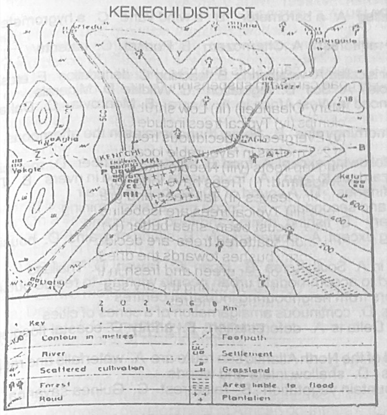
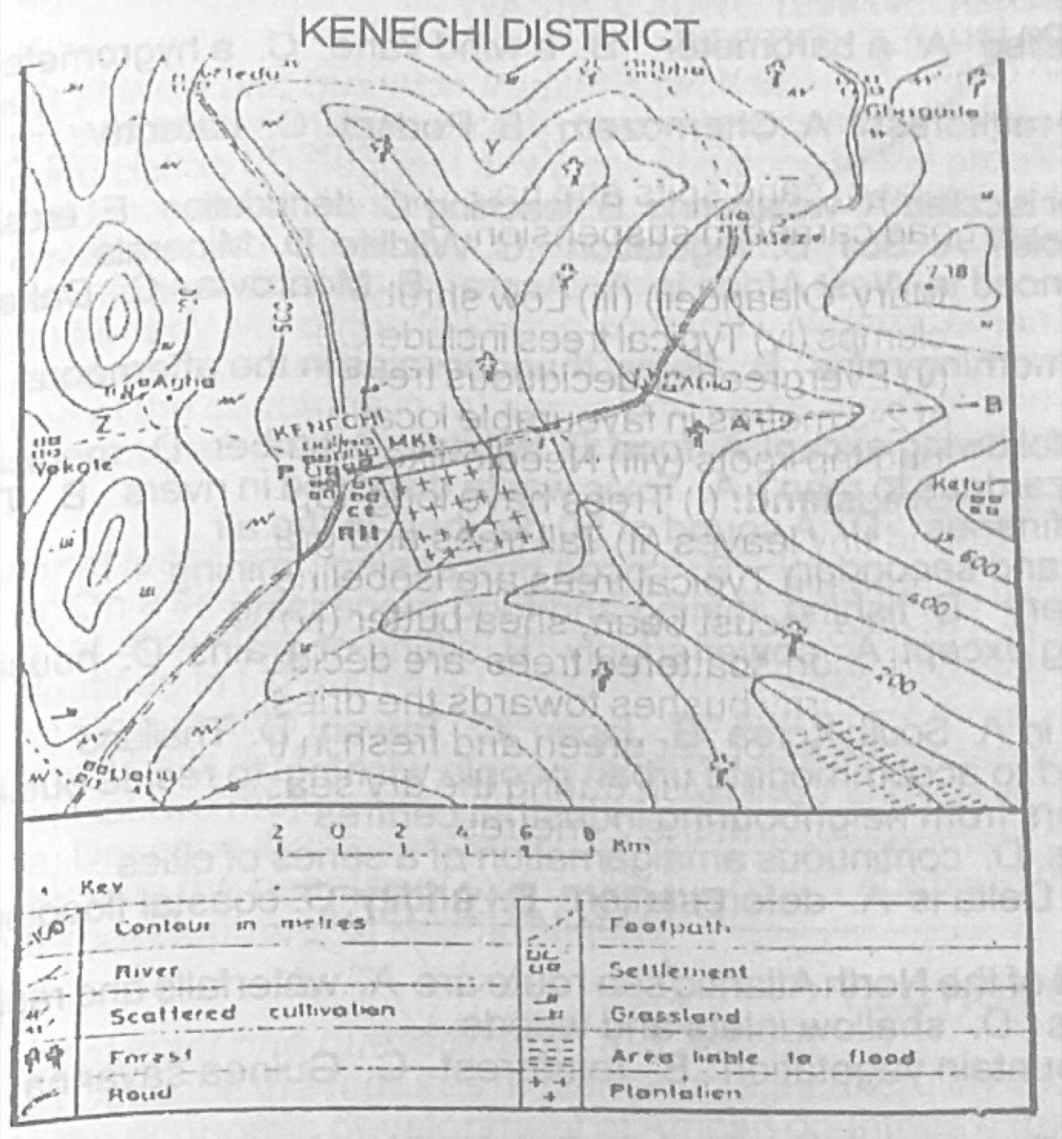
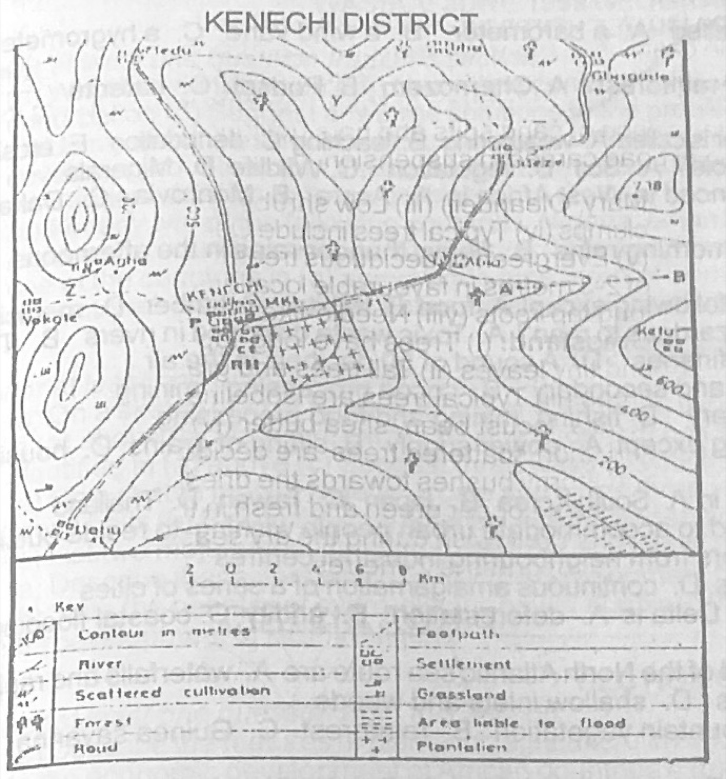
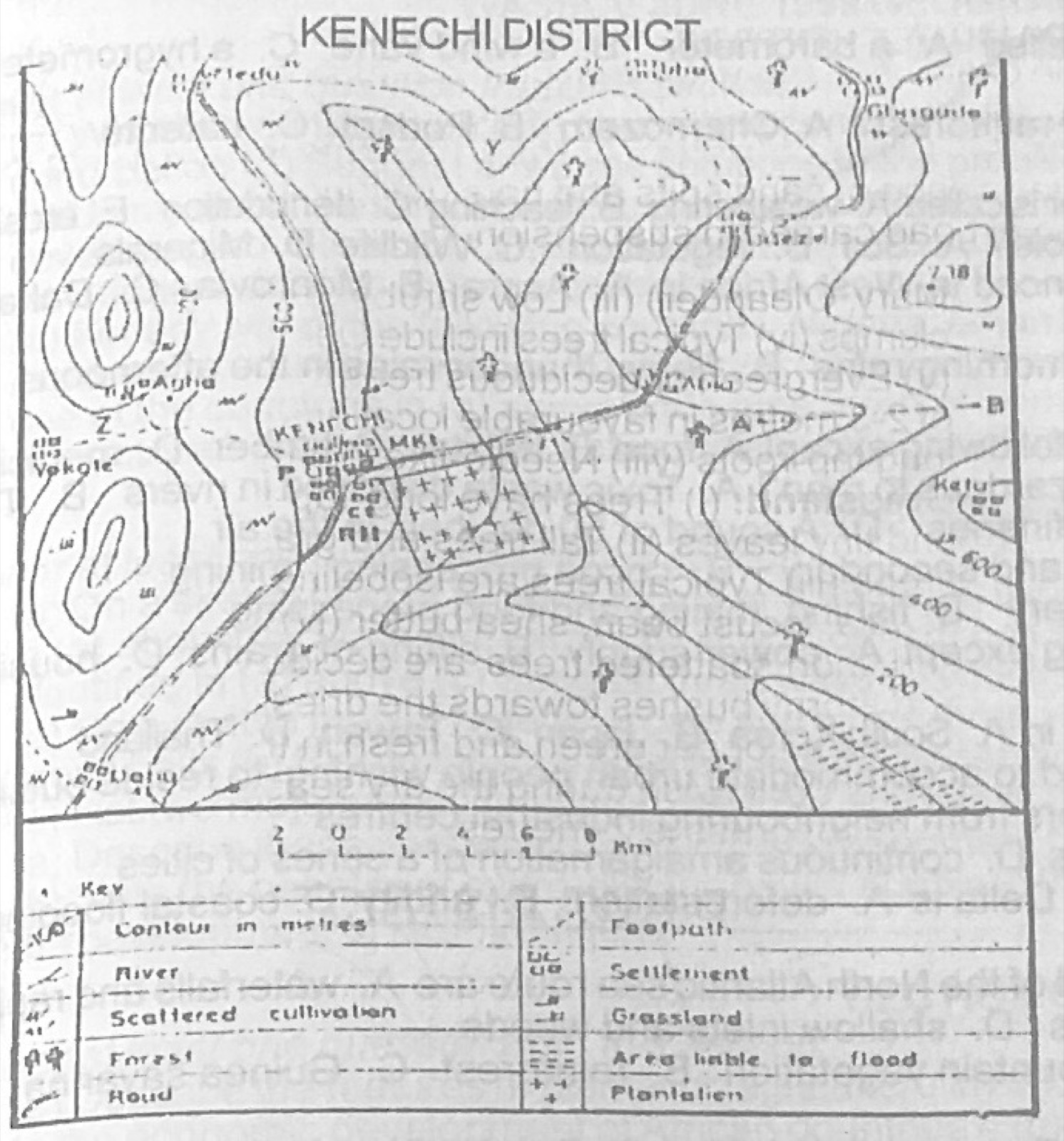
Use the map of KENECHI district to answer this question. What is the scale of the map in Representative Fraction (R.F)

Diagram for this question
  1. A.1:200,000
  2. B.1:100,000
  3. C.1:50,000
  4. D.1:20,000
Show the answer and explanation

Answer: A (1:200,000)

Explanation

Each division of the linear scale (2 km) measures about 1 cm on the original map; 1 cm to 2 km = 1 cm to 200,000 cm, i.e. 1:200,000.

Open this question

Question 2

Map Scale, Distance and Direction

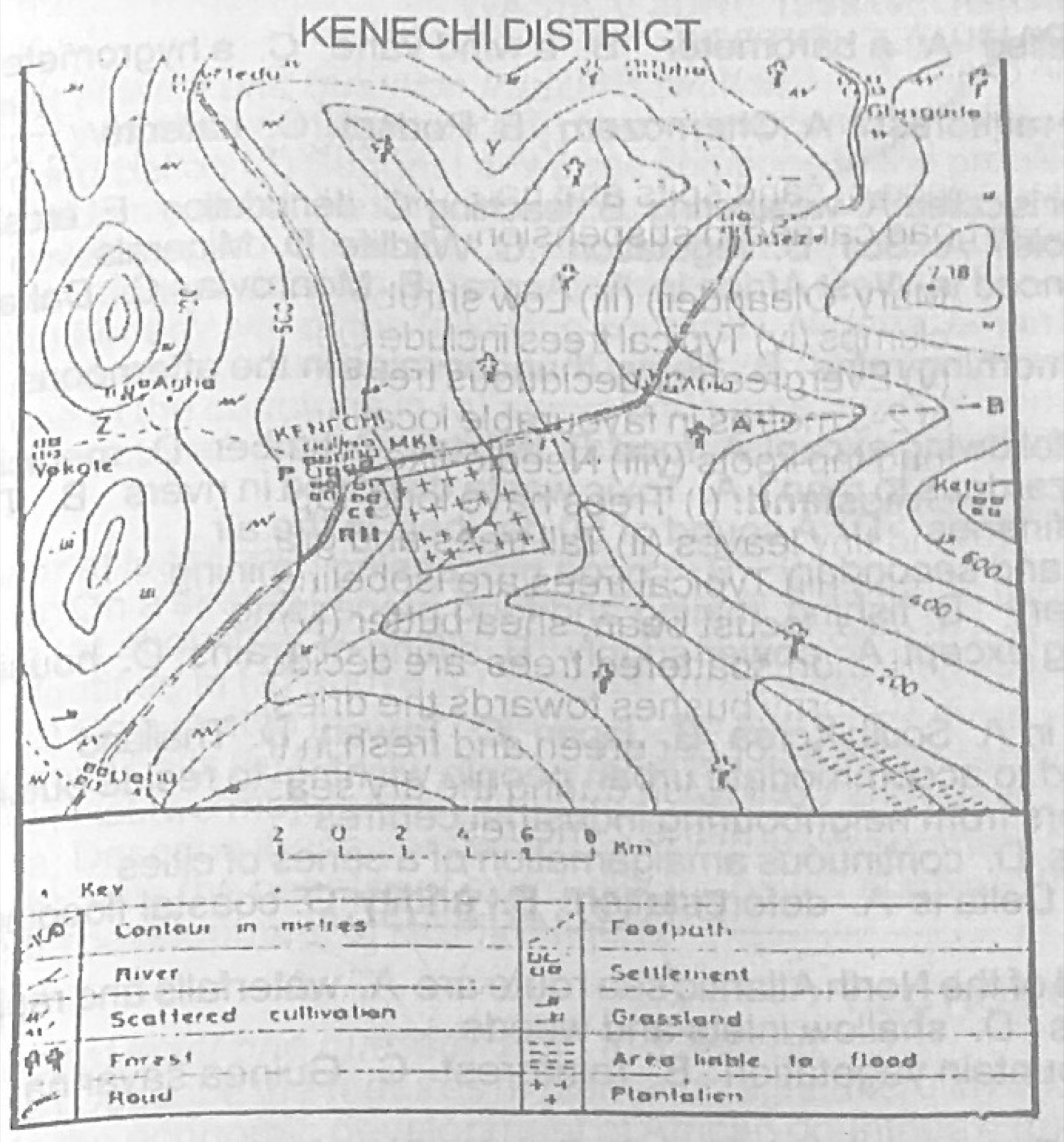
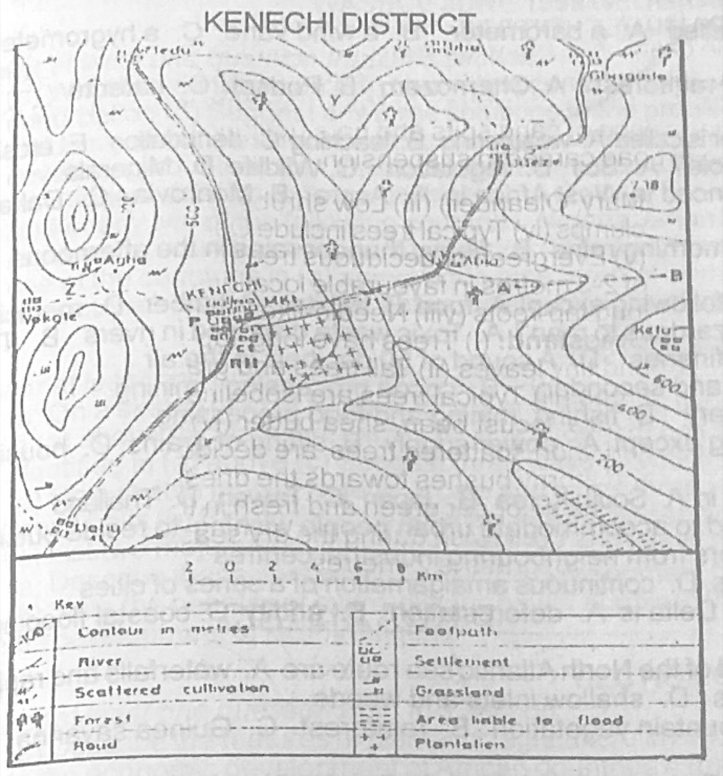
Use the map of KENECHI district to answer this question. The acutal distance of KENECHI from Abia along the road is approximately

Diagram for this question
  1. A.5.5cm
  2. B.5.5km
  3. C.11.0cm
  4. D.11.0km
Show the answer and explanation

Answer: D (11.0km)

Explanation

Measure the road on the map (about 5.5 cm) and multiply by 2 km per cm: about 11 km. An actual distance must be in km, not cm.

Open this question

Question 3

Map Scale, Distance and Direction

Use the map of KENECHI district to answer this question. If the map is enlarged to twice its size, what will be the scale of the enlarged map?

Diagram for this question
  1. A.1:50,000
  2. B.1:100,000
  3. C.1:150,000
  4. D.1:200,000
Show the answer and explanation

Answer: B (1:100,000)

Explanation

Doubling the map size halves the ground distance per cm: 1:200,000 becomes 1:100,000.

Open this question

Question 4

Map Scale, Distance and Direction

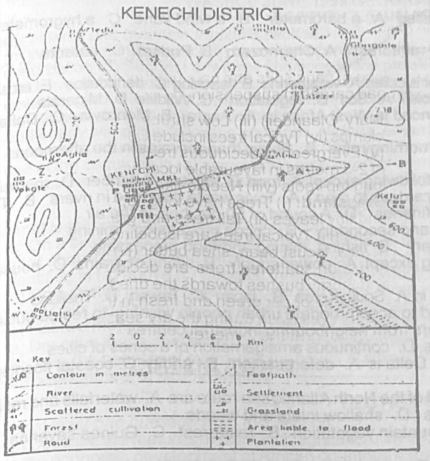
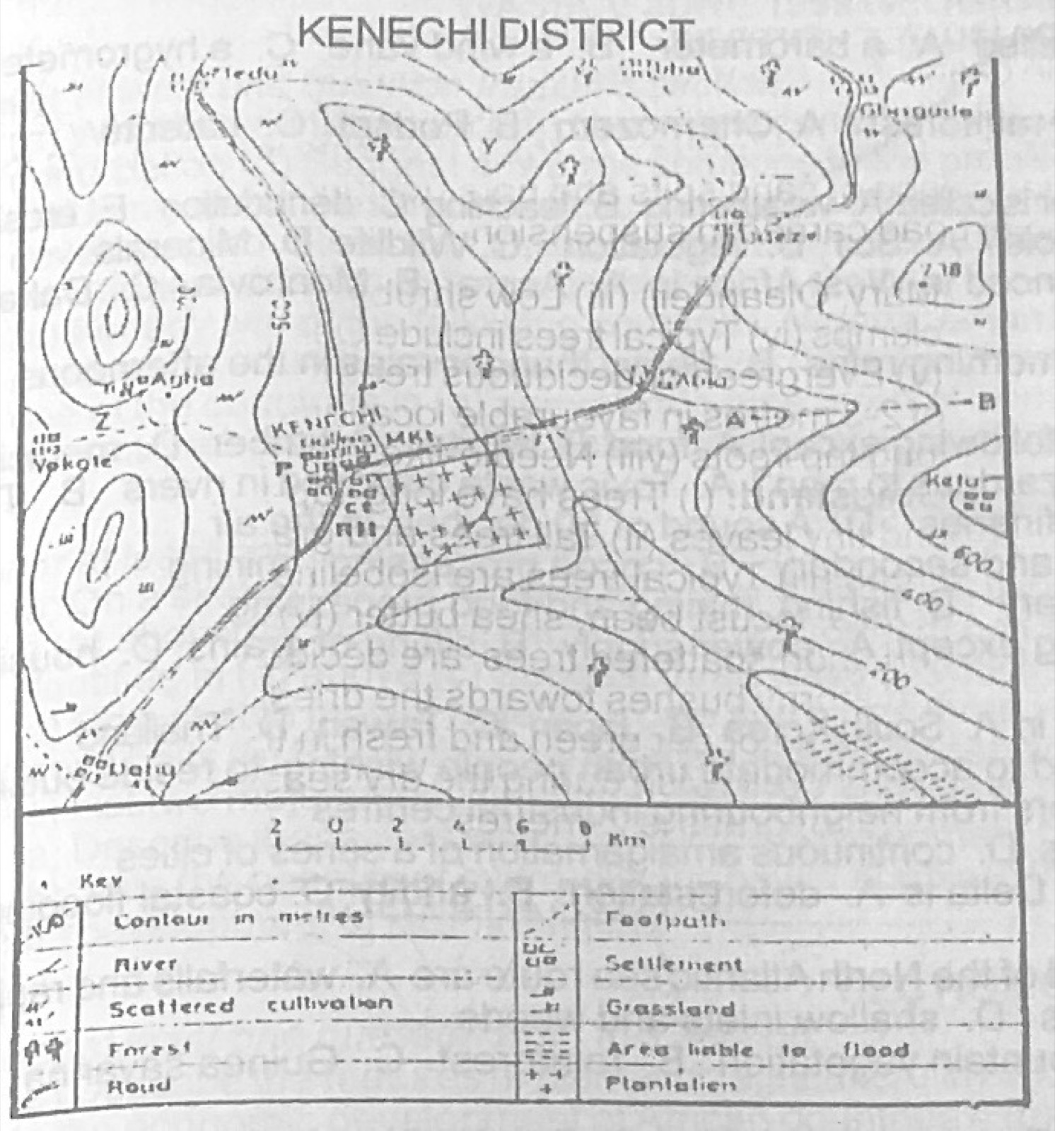
Use the map of KENECHI district to answer this question. The direction of the plantation of KENECHI from Dabu is

Diagram for this question
  1. A.N 10°E
  2. B.N 45°E
  3. C.S 45°W
  4. D.N50°W
Show the answer and explanation

Answer: B (N 45°E)

Explanation

The plantation lies north-east of Dabu, i.e. about N 45° E.

Open this question

Question 5

Relief and Map Interpretation

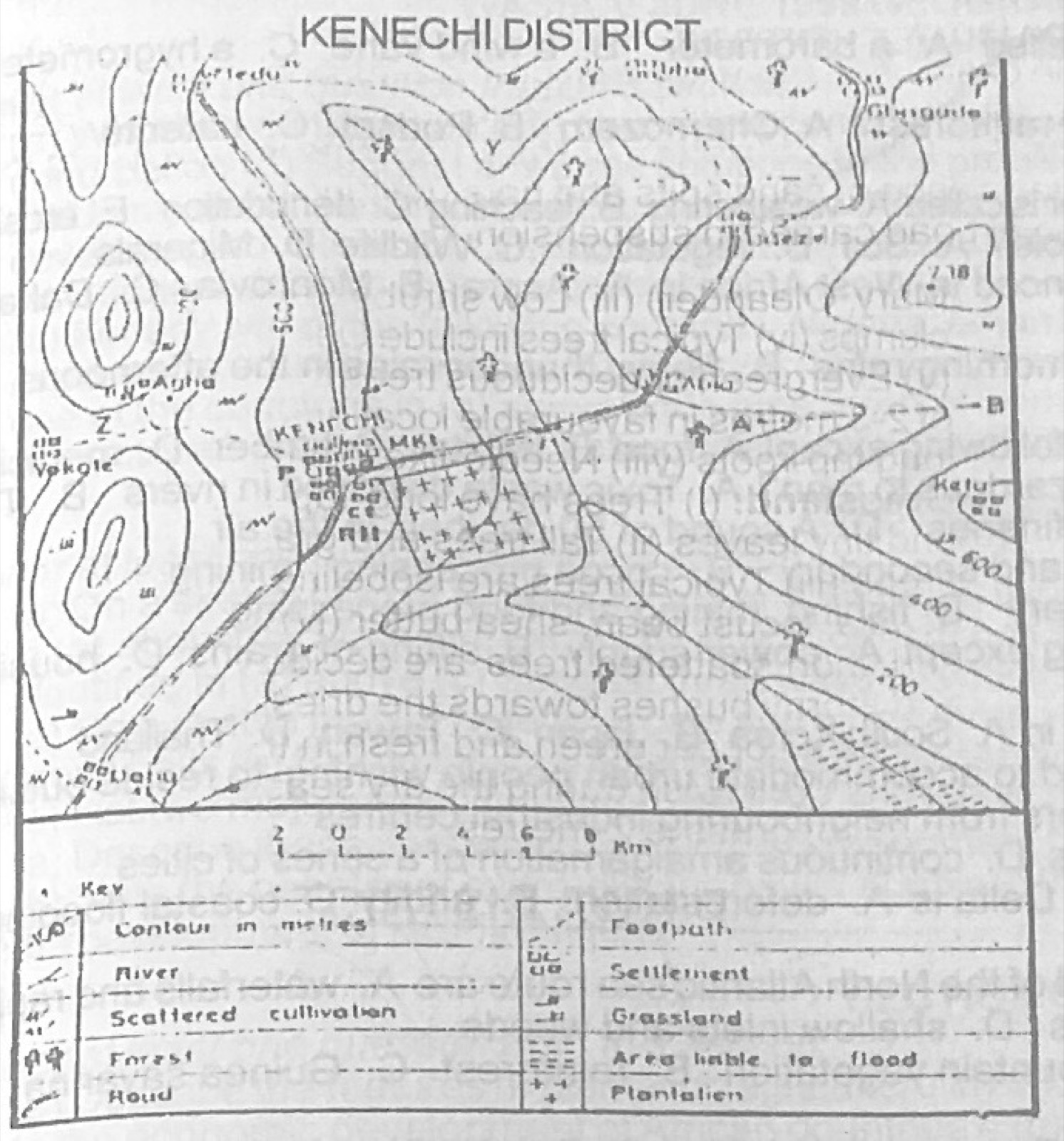
Use the map of KENECHI district to answer this question. The feature marked Y near the northern border of the map is called a

Diagram for this question
  1. A.spur
  2. B.headland
  3. C.valley
  4. D.bridge
Show the answer and explanation

Answer: A (spur)

Explanation

At Y the contours form a tongue of high land pointing down into lower ground: a spur.

Open this question

Question 6

Relief and Map Interpretation

Use the map of KENECHI district to answer this question. The feature marked Z on the western part of the map near Vokote is called a

Diagram for this question
  1. A.ridge
  2. B.scarp
  3. C.pass
  4. D.gap
Show the answer and explanation

Answer: C (pass)

Explanation

Z is a low point between two hills on the western high ground, used as a way through: a pass.

Open this question

Question 7

Relief and Map Interpretation

Use the map of KENECHI district to answer this question. The feature marked A to B represents a

Diagram for this question
  1. A.dry valley
  2. B.inselberg
  3. C.knoll
  4. D.watershed
Show the answer and explanation

Answer: A (dry valley)

Explanation

A to B follows a valley shown by V-shaped contours but no river is drawn in it, so it is a dry valley.

Open this question

Question 8

Map Scale, Distance and Direction

Use the map of KENECHI district to answer this question. What is the area of the plantation in Kenechi?

Diagram for this question
  1. A.20km²
  2. B.16km²
  3. C.12km²
  4. D.8km²
Show the answer and explanation

Answer: D (8km²)

Explanation

Measure the length and width of the plantation and convert with the scale (2 km per cm), then multiply.

Open this question

Question 9

Relief and Map Interpretation

Use the map of KENECHI district to answer this question. Which crop is best suited in the south-eastern corner of the area shown on the map?

Diagram for this question
  1. A.Cotton
  2. B.Tea
  3. C.Cocoa
  4. D.Rice
Show the answer and explanation

Answer: D (Rice)

Explanation

The south-east is low land marked 'area liable to flood'; waterlogged land suits rice.

Open this question

Question 10

Relief and Map Interpretation

Use the map of KENECHI district to answer this question. Which of the following pairs of towns are intervisible?

Diagram for this question
  1. A.Vokote and Dabu
  2. B.Kenechi and Udeze
  3. C.Gbagada and Ketu
  4. D.Medu and Tiba
Show the answer and explanation

Answer: D (Medu and Tiba)

Explanation

Two places are intervisible when no higher ground lies on the straight line between them.

Open this question

Question 11

Statistical Maps and Diagrams

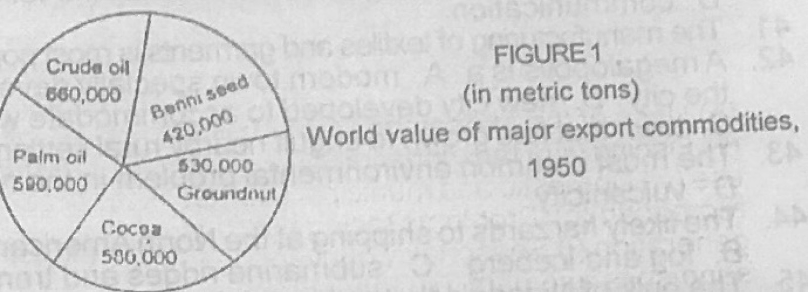
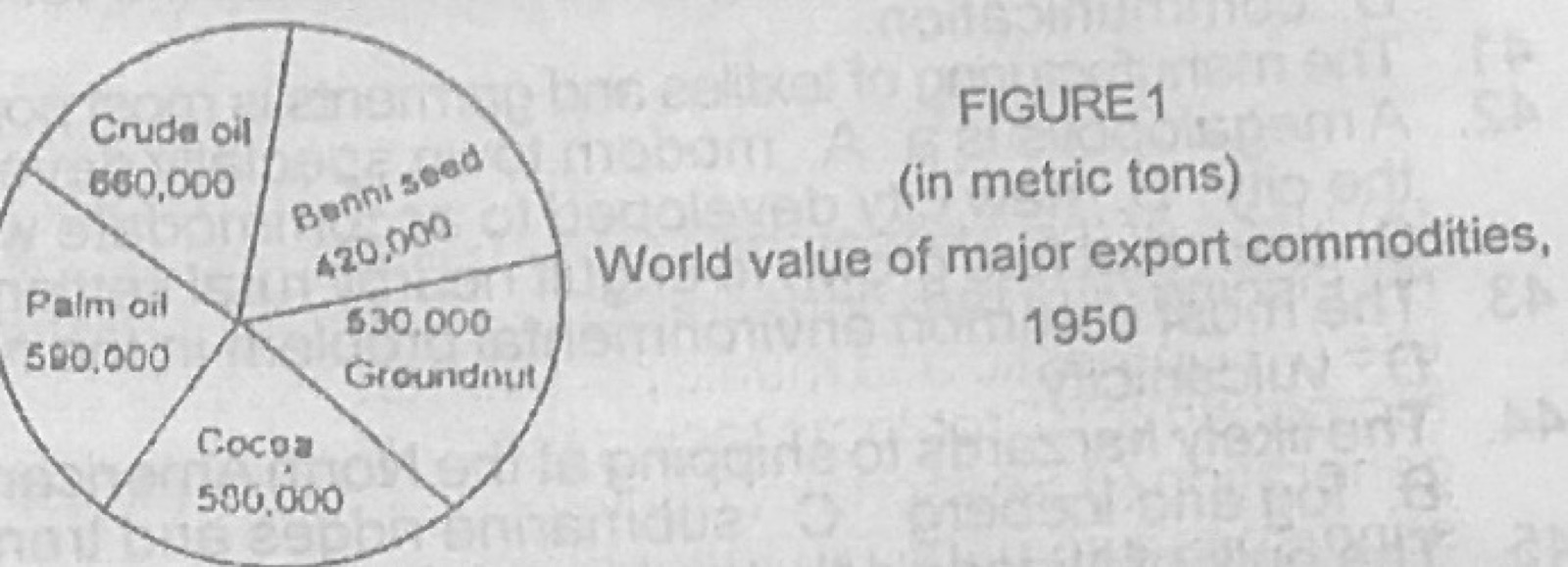
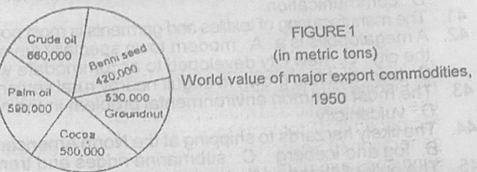
Use Figure 1 (world value of major export commodities, 1950, in metric tons: crude oil 660,000; benni seed 420,000; groundnut 530,000; cocoa 580,000; palm oil 590,000) to answer this question. The figure 1 is a

Diagram for this question
  1. A.wind rose
  2. B.pie chart
  3. C.proportional circle
  4. D.divided proportional circle
Show the answer and explanation

Answer: B (pie chart)

Explanation

A single circle divided into sectors in proportion to each value is a pie chart.

Open this question

Question 12

Statistical Maps and Diagrams

Use Figure 1 (world value of major export commodities, 1950, in metric tons: crude oil 660,000; benni seed 420,000; groundnut 530,000; cocoa 580,000; palm oil 590,000) to answer this question. The total value of the word's export commodities represented in Fig 1 is

Diagram for this question
  1. A.1,000,000 metric tons
  2. B.1:250,000 metric tons
  3. C.2,678,000 metric tons
  4. D.2,780,000 metric tons
Show the answer and explanation

Answer: D (2,780,000 metric tons)

Explanation

660,000 + 420,000 + 530,000 + 580,000 + 590,000 = 2,780,000 metric tons.

Open this question

Question 13

Statistical Maps and Diagrams

Use Figure 1 (world value of major export commodities, 1950, in metric tons: crude oil 660,000; benni seed 420,000; groundnut 530,000; cocoa 580,000; palm oil 590,000) to answer this question. What percentage of the world export commodities in figure 1 is represented by crude oil?

Diagram for this question
  1. A.54.4%
  2. B.42.8%
  3. C.32.47%
  4. D.23.74%
Show the answer and explanation

Answer: D (23.74%)

Explanation

660,000 ÷ 2,780,000 × 100 = 23.74%.

Open this question

Question 15

Rocks

Coal and mineral oil are usually found embedded in

  1. A.crystalline rocks
  2. B.igneous rocks
  3. C.metamorphic rocks
  4. D.sedimentary rocks
Show the answer and explanation

Answer: D (sedimentary rocks)

Explanation

Coal and oil form from buried plant and animal remains, so they occur in sedimentary rocks.

Open this question

Question 16

The Earth and Solar System

When the sun is overhead at 23½°S, all places at 23½°N experience

  1. A.total day light
  2. B.shorter days and longer nights
  3. C.longer days and shorter nights
  4. D.equal days and nights
Show the answer and explanation

Answer: B (shorter days and longer nights)

Explanation

When the sun is over the Tropic of Capricorn (22 December), it is winter in the northern hemisphere, so days are shorter there.

Open this question

Question 17

The Earth and Solar System

The earth lies between

  1. A.Mercury and Venus
  2. B.Mars and Jupiter
  3. C.Venus and Mars
  4. D.Jupiter and Saturn
Show the answer and explanation

Answer: C (Venus and Mars)

Explanation

The order from the sun is Mercury, Venus, Earth, Mars, so the earth lies between Venus and Mars.

Open this question

Question 18

Latitude, Longitude and Time

If A is located on latitude 6°N and B on latitude 12°N, what is the distance between the two places?

  1. A.1.998km
  2. B.777km
  3. C.666km
  4. D.66.6km
Show the answer and explanation

Answer: C (666km)

Explanation

6° of latitude × 111 km per degree = 666 km.

Open this question

Question 19

Earth Movements and Vulcanicity

The separation of ancient Gondwana land into different land masses was caused mainly by

  1. A.isostatic shift
  2. B.earthquakes
  3. C.vulcanicity
  4. D.continental drift
Show the answer and explanation

Answer: D (continental drift)

Explanation

Gondwanaland broke up as the continents slowly moved apart: continental drift.

Open this question

Question 20

Rocks

Marble and Schist are examples of

  1. A.sedimentary rocks
  2. B.volcanic rocks
  3. C.metamorphic rocks
  4. D.plutonic rocks
Show the answer and explanation

Answer: C (metamorphic rocks)

Explanation

Marble (from limestone) and schist (from shale) are rocks changed by heat and pressure: metamorphic.

Open this question

Question 21

Weathering, Erosion and Mass Movement

In which of the following regions would exfoliation commonly occur?

  1. A.Regions with high temperatures and large amount of rainfall
  2. B.Semi-arid regions with large diurnal range of temperature
  3. C.Regions with large amounts of limestone and chalk
  4. D.Regions with luxuriant vegetation cover
Show the answer and explanation

Answer: B (Semi-arid regions with large diurnal range of temperature)

Explanation

Daily heating and cooling of bare rock in dry areas makes outer layers expand, contract and peel off.

Open this question

Question 22

Wind and Desert Landforms

A steep-sided feature with vertical bands of alternate hard and soft rocks, aligned in the direction of the prevailing wind is

  1. A.Mesa
  2. B.Zeugen
  3. C.Yardang
  4. D.Rock pedestal
Show the answer and explanation

Answer: C (Yardang)

Explanation

Vertical hard and soft bands lying along the wind produce yardangs; zeugens form in horizontal layers.

Open this question

Question 23

Rivers and River Landforms

All the following conditions are favourable for the formation of delta except

  1. A.presence of large lakes in the river course
  2. B.availability of adequate sediments
  3. C.absence of strong current at the river mouth
  4. D.presence of sheltered coast
Show the answer and explanation

Answer: A (presence of large lakes in the river course)

Explanation

Lakes along a river trap its sediment, leaving less to build a delta at the mouth.

Open this question

Question 24

Earth Movements and Vulcanicity

Which of the following is responsible for the formation of block mountains?

  1. A.Faulting
  2. B.Sedimentation
  3. C.Folding
  4. D.Deposition
Show the answer and explanation

Answer: A (Faulting)

Explanation

Block mountains are raised between parallel faults.

Open this question

Question 25

Rivers and River Landforms

The features commonly found along the lower course of a river are

  1. A.windgaps
  2. B.rapids
  3. C.waterfalls
  4. D.meanders
Show the answer and explanation

Answer: D (meanders)

Explanation

On the gentle lower course the river swings from side to side in meanders; rapids and falls belong to the upper course.

Open this question

Question 26

Oceans and Lakes

Which of the following ocean currents lowers the temperature of the adjacent coastland?

  1. A.Benguela current
  2. B.Kuro siwo current
  3. C.Brazillian current
  4. D.Agulhas current
Show the answer and explanation

Answer: A (Benguela current)

Explanation

The Benguela current is cold and cools the south-west coast of Africa; the others are warm.

Open this question

Question 27

Climate

Use the information in the table below (Station Z).
Month: J, F, M, A, M, J, J, A, S, O, N, D
Temp (°C): 21, 24, 26, 32, 31, 29, 27, 25, 27, 27, 26, 35
Precipitation (mm): 0, 0, 3, 13, 71, 121, 211, 302, 138, 12, 0, 0
What is the mean monthly temperature of Station Z?

  1. A.25°C
  2. B.27.5°C
  3. C.28.5°C
  4. D.33°C
Show the answer and explanation

Answer: B (27.5°C)

Explanation

Sum of the 12 temperatures = 330; 330 ÷ 12 = 27.5°C.

Open this question

Question 28

Climate

Use the information in the table below (Station Z).
Month: J, F, M, A, M, J, J, A, S, O, N, D
Temp (°C): 21, 24, 26, 32, 31, 29, 27, 25, 27, 27, 26, 35
Precipitation (mm): 0, 0, 3, 13, 71, 121, 211, 302, 138, 12, 0, 0
How many months of dry season has the Station?

  1. A.4
  2. B.5
  3. C.7
  4. D.8
Show the answer and explanation

Answer: C (7)

Explanation

Counting months with less than 50 mm of rain (Jan, Feb, Mar, Apr, Oct, Nov, Dec) gives 7 dry months.

Open this question

Question 29

Climate

Use the information in the table below (Station Z).
Month: J, F, M, A, M, J, J, A, S, O, N, D
Temp (°C): 21, 24, 26, 32, 31, 29, 27, 25, 27, 27, 26, 35
Precipitation (mm): 0, 0, 3, 13, 71, 121, 211, 302, 138, 12, 0, 0
The annual rainfall amount for the Station is

  1. A.72.6mm
  2. B.299mm
  3. C.302mm
  4. D.871mm
Show the answer and explanation

Answer: D (871mm)

Explanation

0+0+3+13+71+121+211+302+138+12+0+0 = 871 mm.

Open this question

Question 30

Weather

If the temperature of sea level is 30°C, the temperature of the air at a height of 2000 metres will be approximately

  1. A.25°C
  2. B.20°C
  3. C.18°C
  4. D.10°C
Show the answer and explanation

Answer: C (18°C)

Explanation

Temperature falls about 6°C per 1000 m: 30 − (2 × 6) = 18°C.

Open this question

Question 31

Weather

The instrument used for measuring wind velocity is called

  1. A.a barometer
  2. B.a wind vane
  3. C.a hygrometer
  4. D.an anemometer
Show the answer and explanation

Answer: D (an anemometer)

Explanation

An anemometer measures wind speed; a wind vane shows direction.

Open this question

Question 32

Soils

Which of the following soil types supports the tropical rainforest?

  1. A.Chernozem
  2. B.Podsol
  3. C.Laterite
  4. D.Terta rosa
Show the answer and explanation

Answer: C (Laterite)

Explanation

Hot, wet conditions under the rainforest produce red, leached lateritic soils; podsols form under coniferous forest.

Open this question

Question 33

Weathering, Erosion and Mass Movement

The removal of soil or rock particles by wind or running water is called

  1. A.weathering
  2. B.leaching
  3. C.denudation
  4. D.erosion
Show the answer and explanation

Answer: D (erosion)

Explanation

Erosion is the wearing away and carrying off of soil and rock by agents such as wind and water.

Open this question

Question 34

Environmental Resources

Which of the following natural resources is non-renewable?

  1. A.Soil
  2. B.Vegetation
  3. C.Wildlife
  4. D.Minerals
Show the answer and explanation

Answer: D (Minerals)

Explanation

Minerals take millions of years to form, so once mined they cannot be replaced.

Open this question

Question 35

Climate

Koppen's wet tropical (AF) type of climate is experienced in West Africa in

  1. A.Accra
  2. B.Monrovia
  3. C.Dakar
  4. D.Kano
Show the answer and explanation

Answer: B (Monrovia)

Explanation

Monrovia gets very heavy rain with only a short dry spell, which is Koppen's Af type; Accra lies in the dry coastal belt.

Open this question

Question 36

Climate

Equatorial lowlands usually experience

  1. A.very early morning rains
  2. B.heavy thunder rains in the afternoons
  3. C.strong winds
  4. D.cold nights
Show the answer and explanation

Answer: B (heavy thunder rains in the afternoons)

Explanation

Strong morning heating causes convection, so thunderstorms come in the afternoon.

Open this question

Question 37

Environmental Resources

Vegetation resources can be utilized by man for all the following except

  1. A.food
  2. B.habitat
  3. C.timber
  4. D.medicine
Show the answer and explanation

Answer: B (habitat)

Explanation

Man takes food, timber and medicine from vegetation; habitat is what vegetation provides for wildlife, not a product used by man.

Open this question

Question 38

Environmental Hazards and Conservation

Which of the following forms of pollution is the least harzardous to man?

  1. A.Toxic waste disposed in rivers
  2. B.The use of chemicals for fishing
  3. C.Flaring of gas from refineries
  4. D.A sound of 50 decibels in the air
Show the answer and explanation

Answer: D (A sound of 50 decibels in the air)

Explanation

50 decibels is about the level of normal conversation, which does no harm.

Open this question

Question 39

Manufacturing Industry

Industries are classified as

  1. A.primary, manufacturing and secondary
  2. B.cocoa processing, mining and furniture making
  3. C.primary, secondary and tertiary
  4. D.fishing, mining and food processing
Show the answer and explanation

Answer: C (primary, secondary and tertiary)

Explanation

Industries are grouped as primary (extracting), secondary (manufacturing) and tertiary (services).

Open this question

Question 40

Environmental Resources

Atmospheric resources can be used for all the following except

  1. A.power supply
  2. B.sifting of grains
  3. C.housing
  4. D.communication
Show the answer and explanation

Answer: C (housing)

Explanation

Wind and sun give power, wind is used to winnow grain, and the air carries radio signals; the atmosphere does not provide housing.

Open this question

Question 41

Manufacturing Industry

The manufacturing of textiles and garments is most popular in

  1. A.South Korea
  2. B.Japan
  3. C.Taiwan
  4. D.Thailand
Show the answer and explanation

Answer: D (Thailand)

Explanation

Thailand's cheap labour has made textiles and clothing one of its leading manufactures.

Open this question

Question 42

Settlement

A megalopolis is a

  1. A.modern town specially developed to accommodate urban people wishing to reside outside the city
  2. B.new city developed to accommodate workers from neighbouring industrial centres
  3. C.town that has grown to engulf nearby rural settlements
  4. D.continuous amalgamation of a series of cities
Show the answer and explanation

Answer: D (continuous amalgamation of a series of cities)

Explanation

A megalopolis is a huge urban region formed when several cities and conurbations join, e.g. Boston to Washington.

Open this question

Question 43

Nigeria: Physical Setting

The most common environmental problem in the Niger Delta is

  1. A.deforestation
  2. B.aridity
  3. C.coastal flooding
  4. D.vulcanicity
Show the answer and explanation

Answer: C (coastal flooding)

Explanation

The delta is low-lying and very wet, so flooding from rivers and the sea is common.

Open this question

Question 44

Transport, Trade and Tourism

The likely harzards to shipping at the North American end of the North Atlantic sea route are

  1. A.waterfalls and rapids
  2. B.fog and iceberg
  3. C.submarine ridges and trenches
  4. D.shallow inlets and weeds
Show the answer and explanation

Answer: B (fog and iceberg)

Explanation

Off Newfoundland the warm Gulf Stream meets the cold Labrador current, causing fog, and the Labrador current carries icebergs.

Open this question

Question 45

Nigeria: People and Economy

The bulk of Nigeria's timber is exploited from the

  1. A.mountain vegetation
  2. B.rainforest
  3. C.Guinea savanna
  4. D.fresh water swamp forest
Show the answer and explanation

Answer: B (rainforest)

Explanation

Most commercial hardwoods come from the southern rainforest belt.

Open this question

Question 46

Nigeria: People and Economy

Nigeria's major trading partners include

  1. A.Britain, USA, Germany and Japan
  2. B.Britain, Ghana, Japan and South Africa
  3. C.Belgium, Germany, Japan and Liberia
  4. D.USA, Belgium, The Gambia and Japan
Show the answer and explanation

Answer: A (Britain, USA, Germany and Japan)

Explanation

Nigeria's biggest trade is with industrial countries such as Britain, the USA, Germany and Japan.

Open this question

Question 48

Nigeria: People and Economy

The Lagos-Kano railway crosses the River Niger at

  1. A.Makurdi
  2. B.Kontagora
  3. C.Jebba
  4. D.Lokoja
Show the answer and explanation

Answer: C (Jebba)

Explanation

The western railway line crosses the Niger by bridge at Jebba.

Open this question

Question 49

Geography of Africa

Most of the copper exported from the Democratic Republic of Congo (Zaire) is produced in and around

  1. A.Kinshasa
  2. B.Lubumbashi
  3. C.Kabinda
  4. D.Kissangani
Show the answer and explanation

Answer: B (Lubumbashi)

Explanation

Copper is mined in the Katanga (Shaba) region around Lubumbashi.

Open this question

Question 50

Agriculture, Fishing and Lumbering

The greatest advantage of perennial irrigation is that

  1. A.two or three crops can be produced in a year from the same piece of land
  2. B.it makes it possible to irrigate larger areas
  3. C.much silt is trapped and this helps to enrich the soil
  4. D.it allows water to be held on the land for several weeks
Show the answer and explanation

Answer: A (two or three crops can be produced in a year from the same piece of land)

Explanation

Water is available all year, so farmers can grow two or three crops each year.

Open this question

Theory question 101

Settlement

(a) What is a conurbation? (b) Name one conurbation each in three different countries (c) State four problems of a conurbation (d) Suggest any three solutions to the problems mentioned in (c) above

Show the model answer
Model answer

(a) A large continuous built-up area formed when several towns grow and merge.
(b) e.g. Lagos-Ikeja (Nigeria), Accra-Tema (Ghana), Cairo-Giza (Egypt), Ruhr (Germany), Greater London/Manchester (UK), Tokyo-Yokohama (Japan).
(c) Overcrowding and slums; traffic congestion; pollution and waste disposal; inadequate water, power and housing; unemployment and crime; flooding from poor drainage.
(d) Urban planning and slum clearance; building satellite towns and new roads/mass transit; better waste management; decentralising industries; rural development to reduce migration.

Explanation

Name a different country for each example.

Open this question

Theory question 102

Manufacturing Industry

(a) Using specific examples, describe any four factors influencing the location of manufacturing industries in developing countries (b) Outline four problems associated with the establishment of heavy industries in West Africa (c) Suggest solution to these problems

Show the model answer
Model answer

(a) Raw materials (cement at Ewekoro near limestone); market (consumer industries in Lagos); power (aluminium smelting at Tema using Akosombo HEP); transport/ports (Apapa, Tema); labour; capital; water; government policy (Ajaokuta steel).
(b) Shortage of capital; lack of skilled labour and technology; unreliable power; poor transport; small market; dependence on imported machines and spare parts; political instability and poor management.
(c) Foreign and joint investment; training of technicians; improving power supply; better roads and railways; regional cooperation (ECOWAS market); stable policies.

Explanation

Use named West African examples.

Open this question

Theory question 103

Transport, Trade and Tourism

(a) For any two of the following countries: Nigeria, Ghana, Sierra Leone and The Gambia, list (i) two commodities exported to countries outside West Africa (ii) two commodities imported from those foreign countries (b) Choose one of the countries in (a) above and name three of its most active foreign customers (c) What four measures can a country which experiences unfavourable balance of trade take to remedy the situation?

Show the model answer
Model answer

(a) Nigeria: exports crude oil, cocoa (rubber, palm kernels); imports machinery, vehicles (chemicals, textiles). Ghana: exports cocoa, gold (timber, bauxite); imports machinery, petroleum products. Sierra Leone: exports diamonds, iron ore/rutile; imports rice, manufactured goods. The Gambia: exports groundnuts, fish; imports rice, textiles.
(b) e.g. Nigeria: USA, Britain, Germany (France, Netherlands, Japan).
(c) Increase and diversify exports; reduce imports through tariffs and quotas; import substitution industries; devaluation/exchange control; process raw materials before export; encourage tourism; borrow or attract investment.

Explanation

Give real commodities for the countries you choose.

Open this question

Theory question 104

Nigeria: People and Economy

(a) On a sketch map of Nigeria, locate and name: (i) two game reserves (ii) one important town in each of the areas in (a) above (b) State three ways by which tourism has affected the lives of the people in any one of the areas identified in (a) above (c) Suggest three ways by which tourism may be boosted in Nigeria

Show the model answer
Model answer

(a) e.g. Yankari Game Reserve (Bauchi), Kainji Lake National Park (New Bussa), Old Oyo National Park (Oyo), Cross River National Park (Calabar/Obudu), Gashaka-Gumti (Serti).
(b) Jobs as guides, hotel and transport workers; income from sale of crafts and food; roads, electricity and other amenities; cultural exchange; but also rising prices and loss of farmland/hunting rights.
(c) Good roads, hotels and security; advertising and publicity; protection and stocking of wildlife; training of staff; government and private investment; stable policies.

Explanation

Place each reserve correctly.

Open this question

Theory question 105

Nigeria: Physical Setting

(a) On a sketch map of Nigeria, locate and name three vegetation zones, choosing at least one from each of the two broad belts (b) Relate the characteristics of the vegetation to the climate of one of the vegetation zones in (a) above (c) List two major agricultural produce from any two of the zones shown in (a) above

Show the model answer
Model answer

(a) Forest belt: mangrove swamp, freshwater swamp, rain forest; savanna belt: Guinea, Sudan, Sahel savanna; shown in correct bands from south to north.
(b) e.g. Rain forest: heavy rain all year and high temperature give tall evergreen trees; continuous growth gives dense layered forest; high humidity supports lianas and epiphytes; heavy rain causes leaching. (Or Sudan savanna: long dry season gives short grasses and scattered drought-resistant trees, deciduous trees, long roots.)
(c) Rain forest: cocoa, oil palm, rubber, kola, yam; Guinea savanna: yam, maize, guinea corn, rice, benniseed; Sudan savanna: groundnuts, cotton, millet, sorghum.

Explanation

Two broad belts are forest and savanna.

Open this question

Theory question 106

Nigeria: People and Economy

(a) Describe the factors which favour the development of hydro-electric power (HEP) resources (b) State the benefits of hydro-electric power supply to the people of Nigeria (c) Outline three major problems facing the development of HEP in Nigeria

Show the model answer
Model answer

(a) Large rivers with constant volume; heavy, reliable rainfall in the catchment; waterfalls, rapids or steep gradients; narrow valley with firm rock for the dam; large market; capital and technology; lack of other power sources.
(b) Electricity for homes and industries; cheaper than thermal power and renewable; reservoirs for irrigation, fishing and water supply; flood control; navigation; tourism; jobs.
(c) Low water level in the dry season reducing output; silting of reservoirs; high cost of dams and transmission lines; displacement of people; flat land with few good sites; poor maintenance and management; water weeds.

Explanation

Use Kainji, Jebba and Shiroro as examples.

Open this question

Theory question 107

Geography of Africa

(a) Describe the features of plantation agriculture in Africa (b) In what four ways has plantation agriculture contributed to the economic development of African countries? (c) Outline four problems of plantation agriculture

Show the model answer
Model answer

(a) Large estates; single cash crop (monoculture) e.g. rubber in Liberia (Firestone), tea in Kenya, sisal in Tanzania, oil palm; large capital; many hired workers; scientific methods (fertiliser, improved seedlings); processing on the estate; mainly for export; often foreign-owned; good roads/rail to ports.
(b) Foreign exchange; employment; raw materials for industry; government revenue; infrastructure and settlements; transfer of skills.
(c) Price fluctuations on world markets; pests and diseases; labour shortages; high capital costs; land disputes; soil exhaustion; foreign ownership and profit repatriation.

Explanation

Give named crops and countries.

Open this question

Theory question 108

Vegetation

Using specific examples, describe how each of the following factors affect the vegetation of Africa (a) Rainfall (b) Altitude (c) Soil type

Show the model answer
Model answer

(a) Heavy rain all year gives dense evergreen rainforest (Zaire Basin, Guinea coast); seasonal rain gives savanna with tall grass and scattered trees (Sudan, East Africa); very low rain gives desert scrub (Sahara, Kalahari); winter rain gives Mediterranean vegetation (Cape, North Africa).
(b) Temperature falls with height, so vegetation changes upwards from forest to montane forest, bamboo, grassland and alpine plants on Kilimanjaro, Mt Kenya, Ethiopian highlands, Jos Plateau.
(c) Fertile, deep soils support dense forest or crops; poor sandy or lateritic soils support grassland or scrub; waterlogged soils support swamp and mangrove (Niger Delta); salty soils support salt-tolerant plants.

Explanation

Name a place for each effect.

Open this question

Theory question 109

Nigeria: People and Economy

Write a geographical account of irrigation farming in Nigeria under the following headings: (a) Factors that favour the type of agriculture (b) Major farming areas and associated crops (c) Problems

Show the model answer
Model answer

(a) Low, unreliable rainfall and long dry season in the north; rivers and lakes (Sokoto, Kano, Hadejia, Lake Chad); flat land and fadama plains; dams and reservoirs (Bakolori, Tiga, Challawa); government river basin authorities; demand for food.
(b) Sokoto-Rima (Bakolori): rice, wheat, onions; Kano River Project (Tiga): wheat, rice, tomatoes; Hadejia-Jama'are: rice, wheat; South Chad Irrigation Project: wheat, rice, cotton; Bida/Badeggi and Niger valley: rice, sugarcane (Bacita).
(c) High cost of dams and canals; silting and evaporation losses; salinisation and waterlogging; water-borne diseases; displacement of farmers; poor management and maintenance; shrinking water sources.

Explanation

Use named schemes and their crops.

Open this question

Theory question 202

Rivers and River Landforms

(a) With the aid of suitable diagrams, describe the appearance and formation of any two of the following landforms (i) delta (ii) river capture (iii) waterfall (iv) inselberg (b) Show one way in which each of the two features in (a) above is of importance to man

Show the model answer
Model answer

(a) Delta: low, flat, fan/arcuate or bird's-foot shaped land at a river mouth cut by many distributaries (Niger, Nile); formed where a river carrying much load enters a sea or lake with weak currents/tides and deposits it; sheltered coast, gentle offshore slope.
River capture: a stronger river with more vigorous headward erosion cuts back through the divide and diverts the headwaters of a weaker river; leaves elbow of capture, wind gap, misfit/beheaded stream.
Waterfall: steep or vertical drop of a river over a hard rock band, with a plunge pool below; formed where hard rock overlies soft rock, at fault scarps or plateau edges; the soft rock is undercut and the fall retreats upstream (Kwa Falls, Victoria Falls).
Inselberg: isolated steep-sided, dome-shaped rock hill rising from a plain (Idanre, Zuma Rock); formed when surrounding weaker rock is weathered and removed, leaving resistant granite.
Diagrams for the two chosen.
(b) Delta: fertile farmland, fishing, oil; river capture: wind gap as a route; waterfall: HEP and tourism; inselberg: tourism, quarrying, defence.

Explanation

Pick two features and include a labelled diagram for each.

Open this question

Theory question 203

Climate

State with specific examples, how each of the following factors affect(s) the climate of adjacent coastlands: (a) Winds (b) Ocean currents (c) Distance from the sea

Show the model answer
Model answer

(a) Onshore winds from warm seas bring rain and moderate temperatures (south-west monsoon in West Africa; westerlies warming western Europe); offshore winds from the land are dry (harmattan bringing dust and dryness to the Guinea coast); cold winds lower temperatures.
(b) Warm currents raise temperatures and increase rainfall (Guinea current, North Atlantic Drift keeping Norwegian ports ice-free, Mozambique current); cold currents lower temperatures, cause fog and dry coasts (Benguela and the Namib, Canary current and the Sahara coast).
(c) Coastal places have smaller temperature ranges, higher humidity and usually more rain (Lagos, Freetown); inland places have greater ranges and less rain (Kano, Timbuktu).

Explanation

Give a named example for each point.

Open this question

Theory question 204

Rivers and River Landforms

(a) With the aid of annotated diagrams, describe the various stages of a river course (b) Mention four ways in which rivers are of importance to man

Show the model answer
Model answer

(a) Long-profile diagram labelled upper, middle and lower course with cross-sections.
Upper (youthful) course: steep gradient, fast flow; vertical erosion forms narrow V-shaped valleys, gorges, waterfalls, rapids, potholes and interlocking spurs.
Middle (mature) course: gentler gradient; lateral erosion widens the valley; meanders, river cliffs and slip-off slopes; some deposition.
Lower (old) course: very gentle gradient; deposition dominant; wide flood plain, levees, large meanders, ox-bow lakes, braiding, delta or estuary.
(b) Water for domestic, industrial and farm use (irrigation); transport; fishing; HEP; tourism and recreation; boundaries; fertile flood plains.

Explanation

Draw both the long profile and valley cross-sections.

Open this question

Theory question 205

Weather

(a) Name the three types of rainfall (b) With the aid of relevant diagrams describe the formation and characteristics of any two types named in (a) above

Show the model answer
Model answer

(a) Convectional, relief (orographic) and cyclonic (frontal).
(b) Convectional: strong heating of the ground makes moist air rise, cool, condense into cumulonimbus clouds and give heavy showers; afternoon thunderstorms with lightning, short-lived, common in equatorial regions.
Relief: moist wind forced to rise over a mountain, cools and condenses; heavy rain on the windward side; dry, warm rain-shadow on the leeward side (Mt Cameroon, Jos Plateau).
Frontal: warm air rises over cold air along a front in a depression; long periods of steady rain/drizzle; common in temperate latitudes.
Diagrams with arrows for air movement.

Explanation

Each type needs a labelled diagram.

Open this question

Theory question 206

Vegetation

(a) Describe the characteristics of the cool temperate grasslands (b) Outline five factors which affect the distribution of this vegetation type

Show the model answer
Model answer

(a) Short, soft, nutritious grasses (prairies, steppes, pampas, veld, downs); almost treeless except along rivers; grass grows in spring and early summer, dries in late summer and dies back under winter snow; flowers in spring; deep black (chernozem) soils.
(b) Low rainfall (about 250-750 mm) mostly in early summer; continental location far from the sea; cold winters and warm summers; frequent fires; grazing animals; relief (plains); soils; human activity (ploughing for wheat).

Explanation

Link the factors to why trees are few.

Open this question

Theory question 207

Weather

(a) Distinguish between weather and climate (b) Identify and describe any four elements of weather (c) Mention three uses of rainfall data to man

Show the model answer
Model answer

(a) Weather is the state of the atmosphere at a place over a short time (hours or days); climate is the average weather over a long period (about 30-35 years) of a large area.
(b) Temperature (degree of hotness, measured by thermometer); rainfall/precipitation (rain gauge); humidity (amount of water vapour, hygrometer); pressure (barometer); wind speed and direction (anemometer, wind vane); sunshine (sunshine recorder); cloud cover.
(c) Planning planting and harvesting; planning irrigation and water supply; flood control and dam design; aviation and shipping; drawing climatic maps; construction planning.

Explanation

Name the instrument for each element.

Open this question

Theory question 208

Environmental Hazards and Conservation

(a) State three ways in which human activities affect the composition of the atmosphere (b) Describe the physical changes that are likely to be associated with the increasing reduction of the ozone layer in the upper atmosphere

Show the model answer
Model answer

(a) Burning fossil fuels (vehicles, factories, power stations) adds carbon dioxide, sulphur dioxide and smoke; deforestation and bush burning add carbon dioxide and reduce oxygen production; gas flaring; use of CFCs in aerosols and refrigerators; agriculture (methane, fertiliser gases); mining and quarrying dust.
(b) More ultraviolet radiation reaches the earth; rise in temperatures (global warming); melting of ice caps and glaciers; rise in sea level and coastal flooding; changes in rainfall patterns and climate; damage to plants, crops and marine plankton; more skin cancer and eye cataracts.
Explanation

Physical changes mean changes to the environment.

Open this question