WAEC Geography 1995 past questions and answers

68 questions. Try each one, then open the answer to check yourself and read the explanation.

Question 1

Map Scale, Distance and Direction

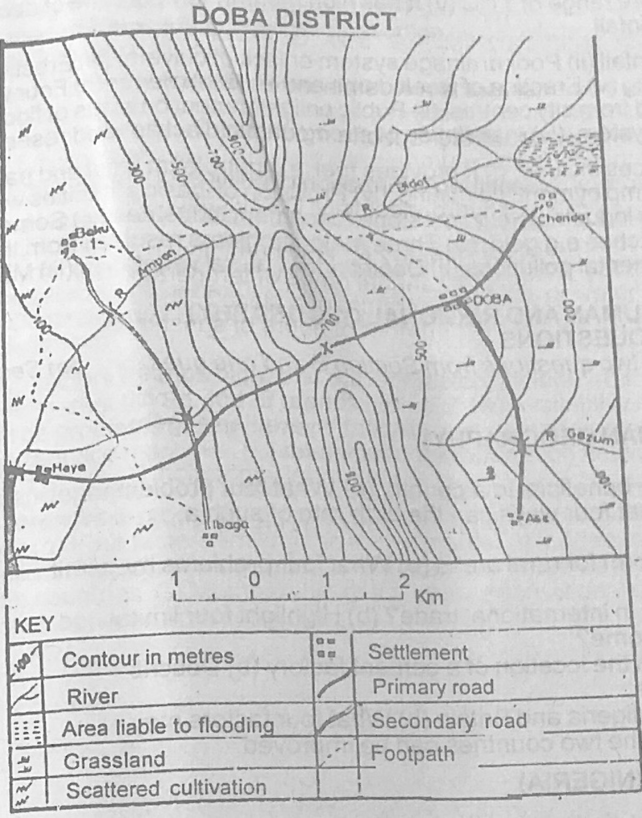
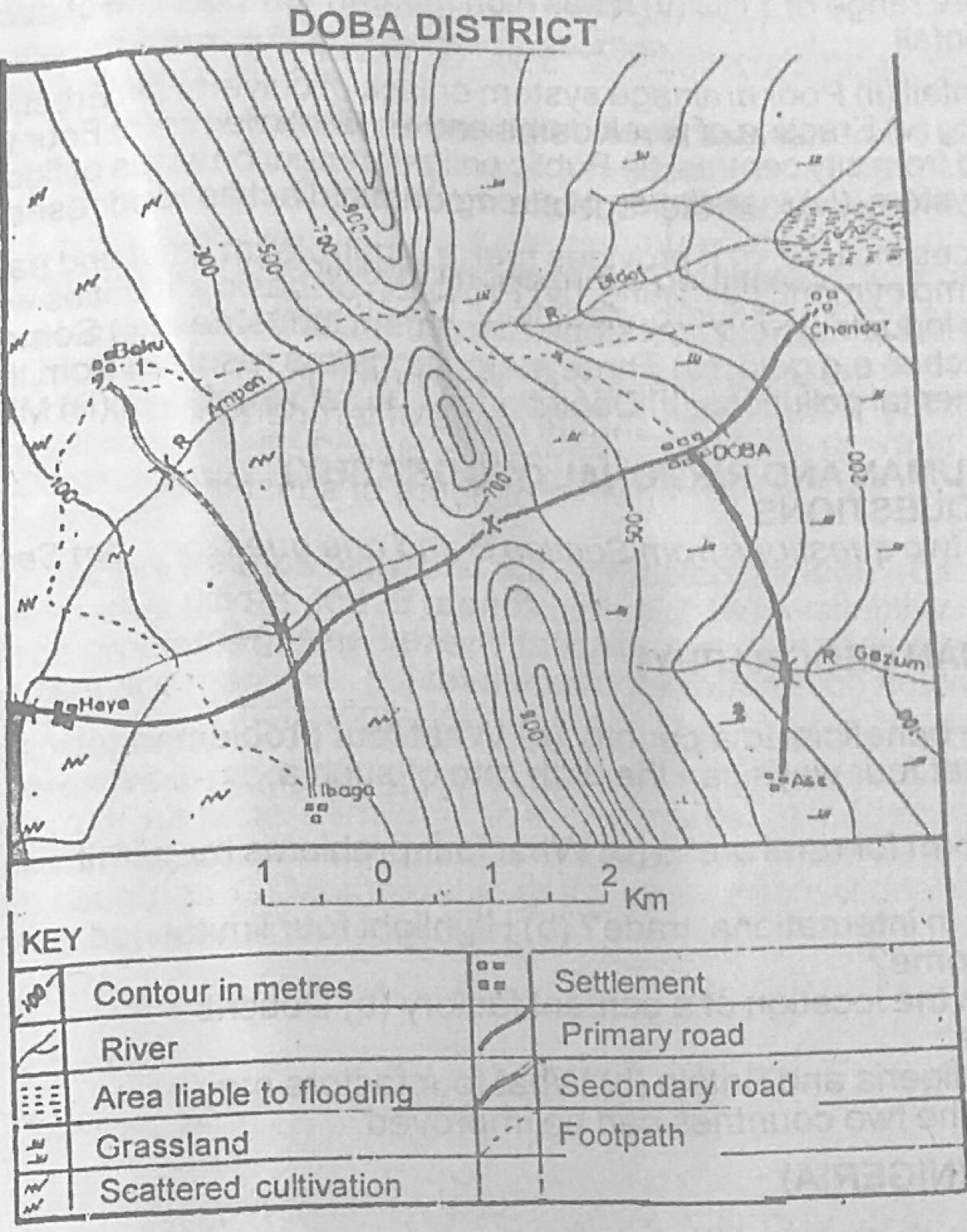
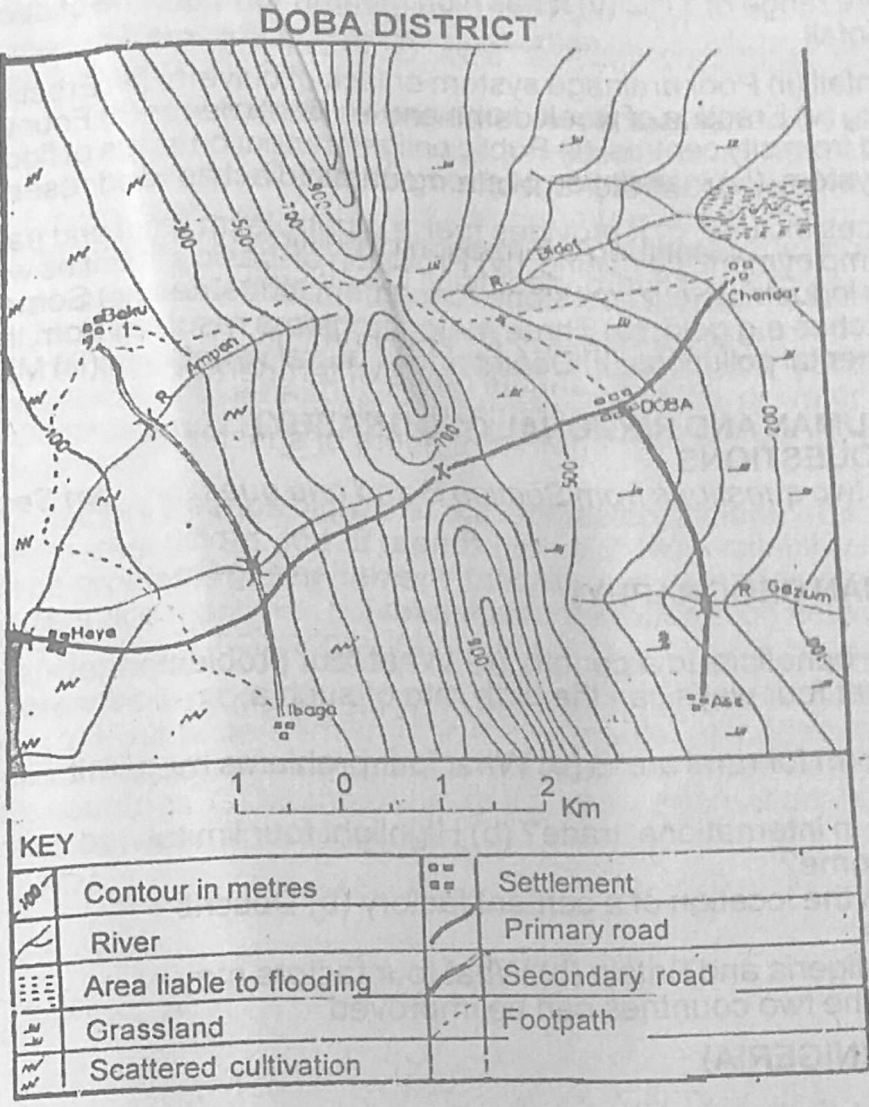
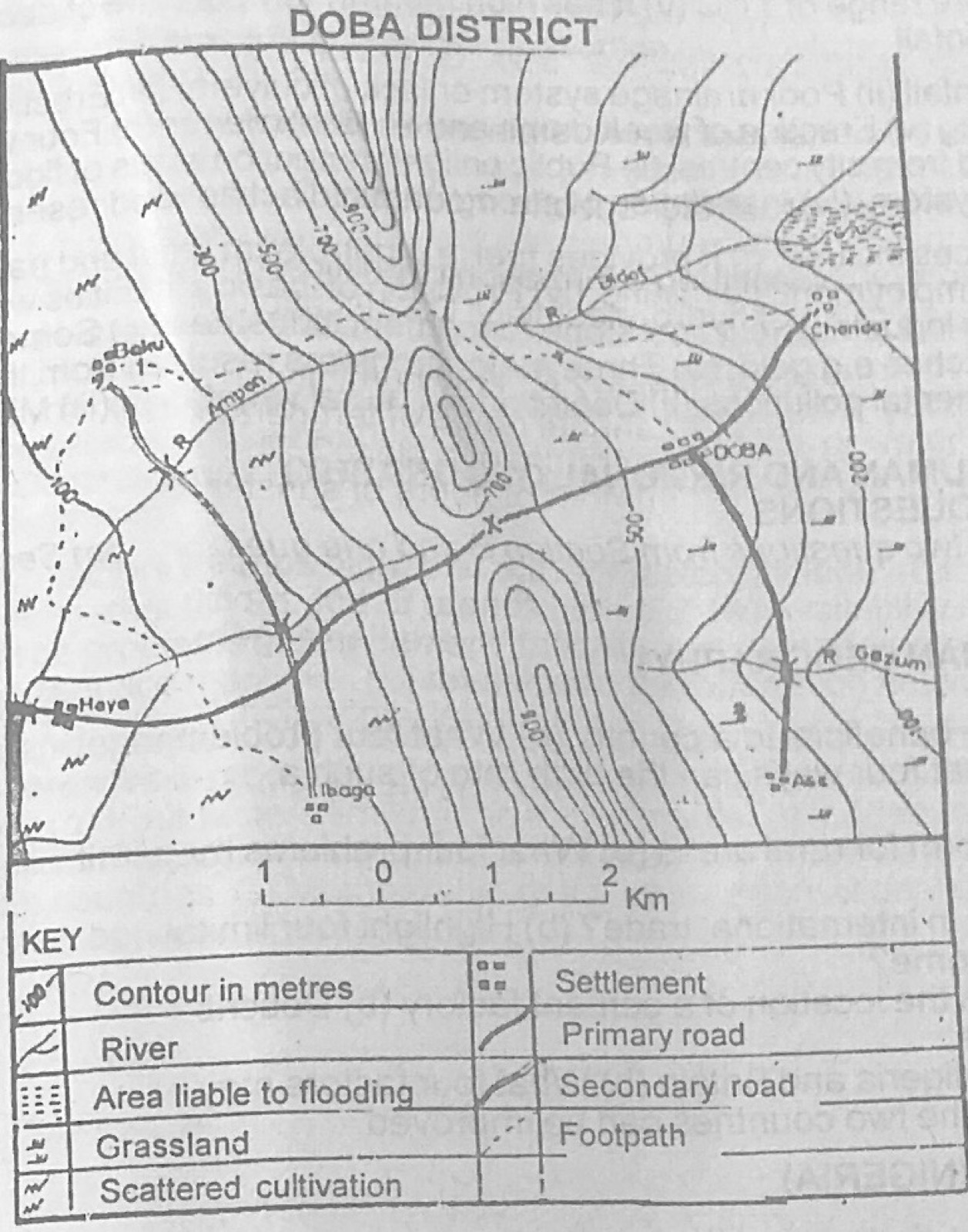
Use the map of DOBA DISTRICT to answer this question. The scale of the map is

Diagram for this question
  1. A.1:2,000
  2. B.1:5,000
  3. C.1:50,000
  4. D.1:100,000
  5. E.1:200,000
Show the answer and explanation

Answer: C (1:50,000)

Explanation

On the linear scale each 1 km division measures about 2 cm, and 2 cm to 1 km is 1 cm to 0.5 km, i.e. 1:50,000.

Open this question

Question 2

Relief and Map Interpretation

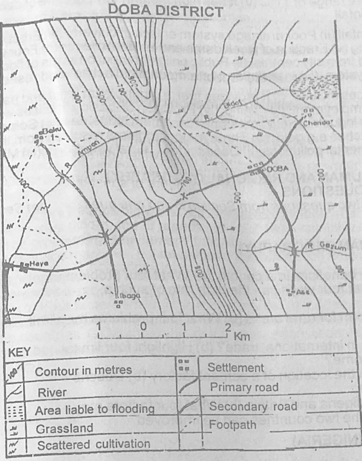
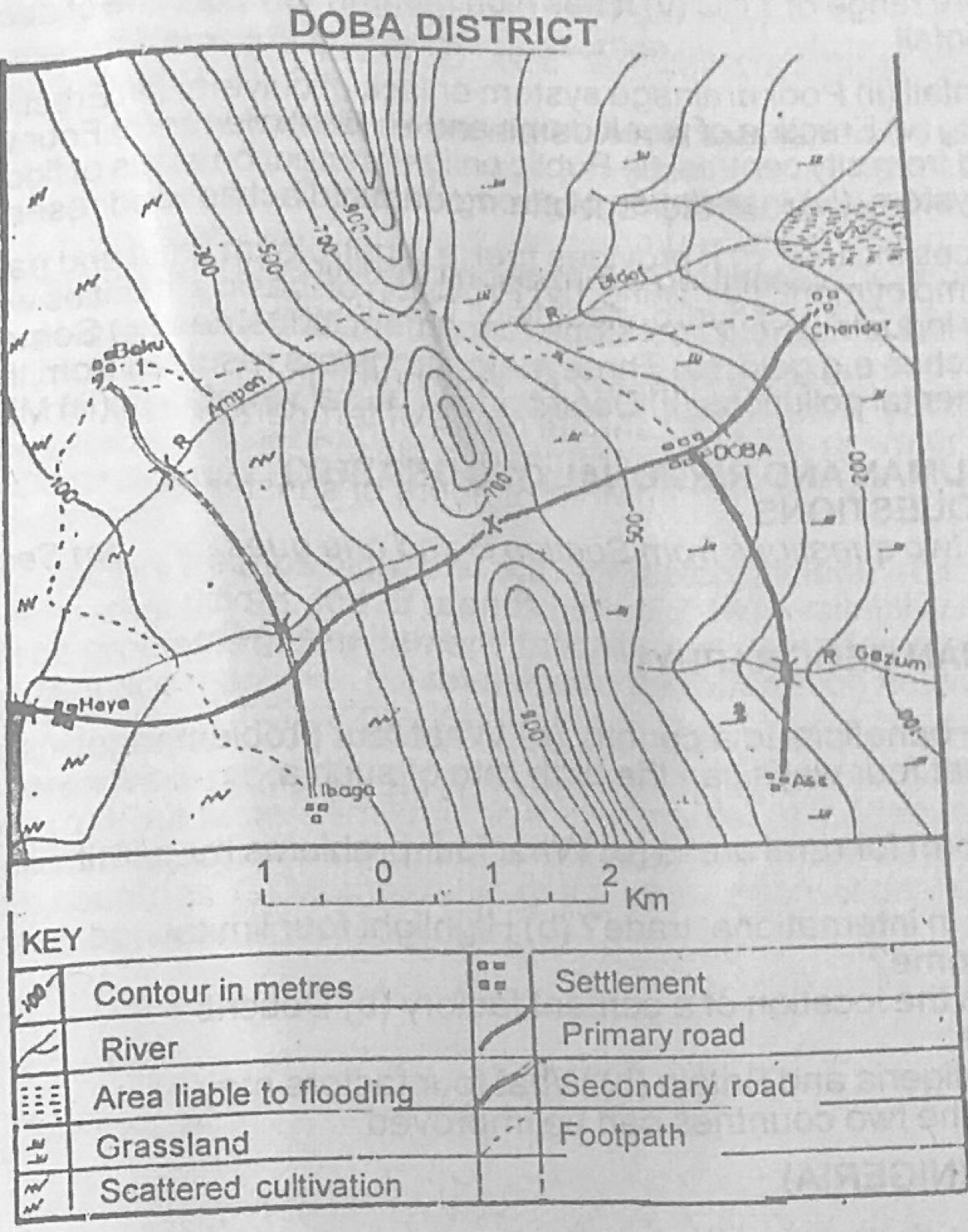
Use the map of DOBA DISTRICT to answer this question. The feature running north-south in the central part of the map is best described as a

Diagram for this question
  1. A.conical hill
  2. B.pyramidal peak
  3. C.knoll
  4. D.plateau
  5. E.ridge
Show the answer and explanation

Answer: E (ridge)

Explanation

The high ground in the centre is long and narrow, with closely spaced contours on both sides, running north to south: that is a ridge.

Open this question

Question 3

Map Scale, Distance and Direction

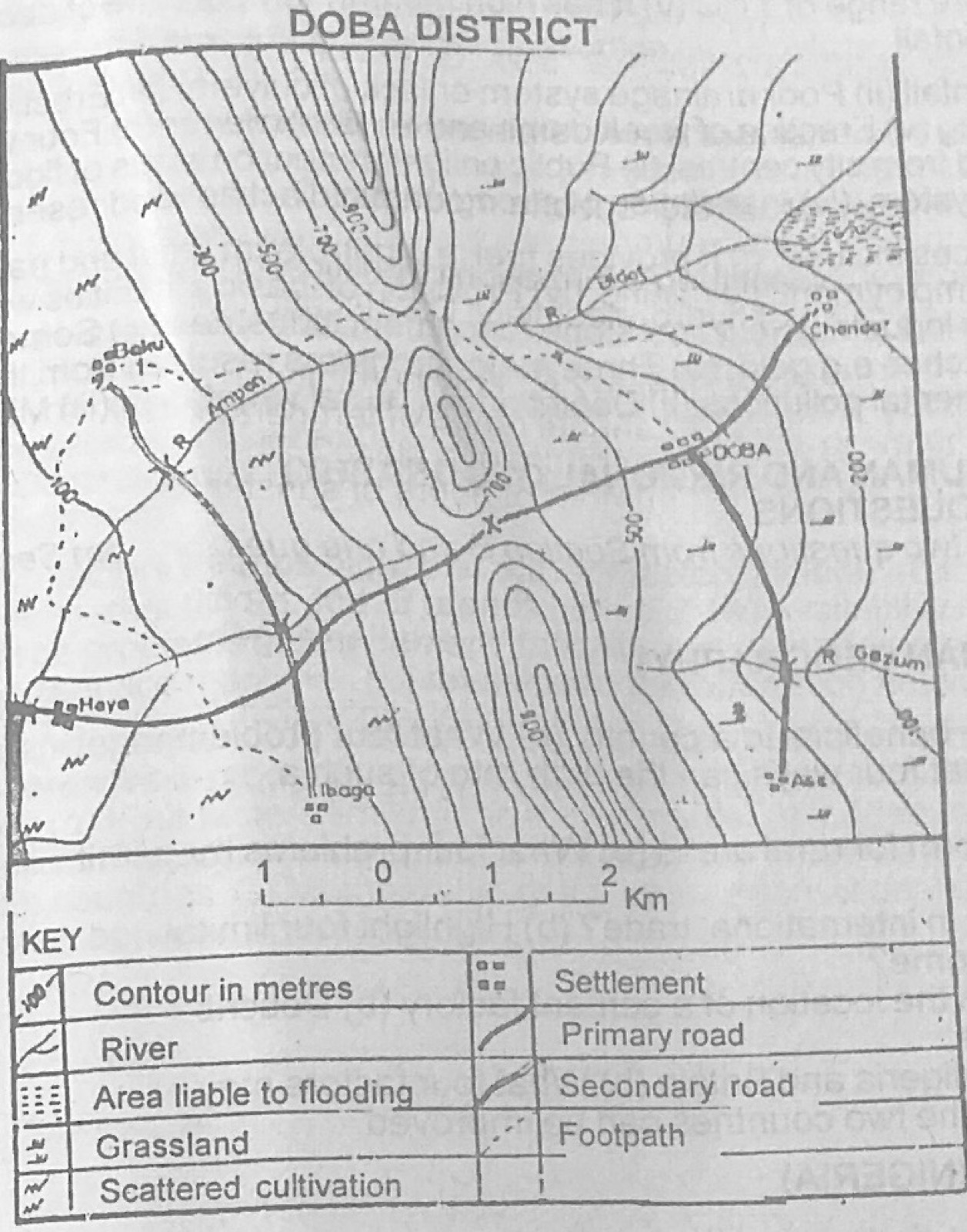
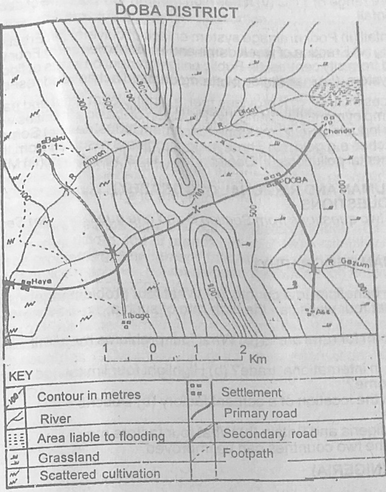
Use the map of DOBA DISTRICT to answer this question. The angular bearing of Baku from Ase is approximately

Diagram for this question
  1. A.045°
  2. B.060°
  3. C.135°
  4. D.225°
  5. E.315°
Show the answer and explanation

Answer: E (315°)

Explanation

Baku lies far to the west-north-west of Ase, so measuring clockwise from north at Ase gives a bearing a little over 300°, closest to 315°.

Open this question

Question 4

Relief and Map Interpretation

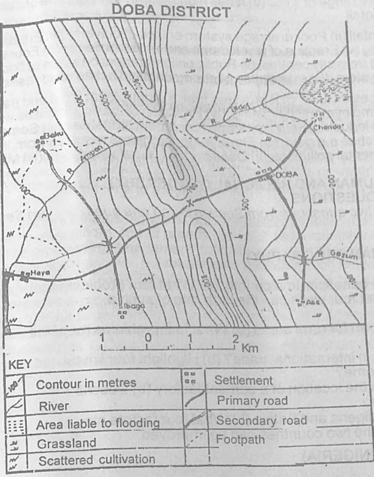
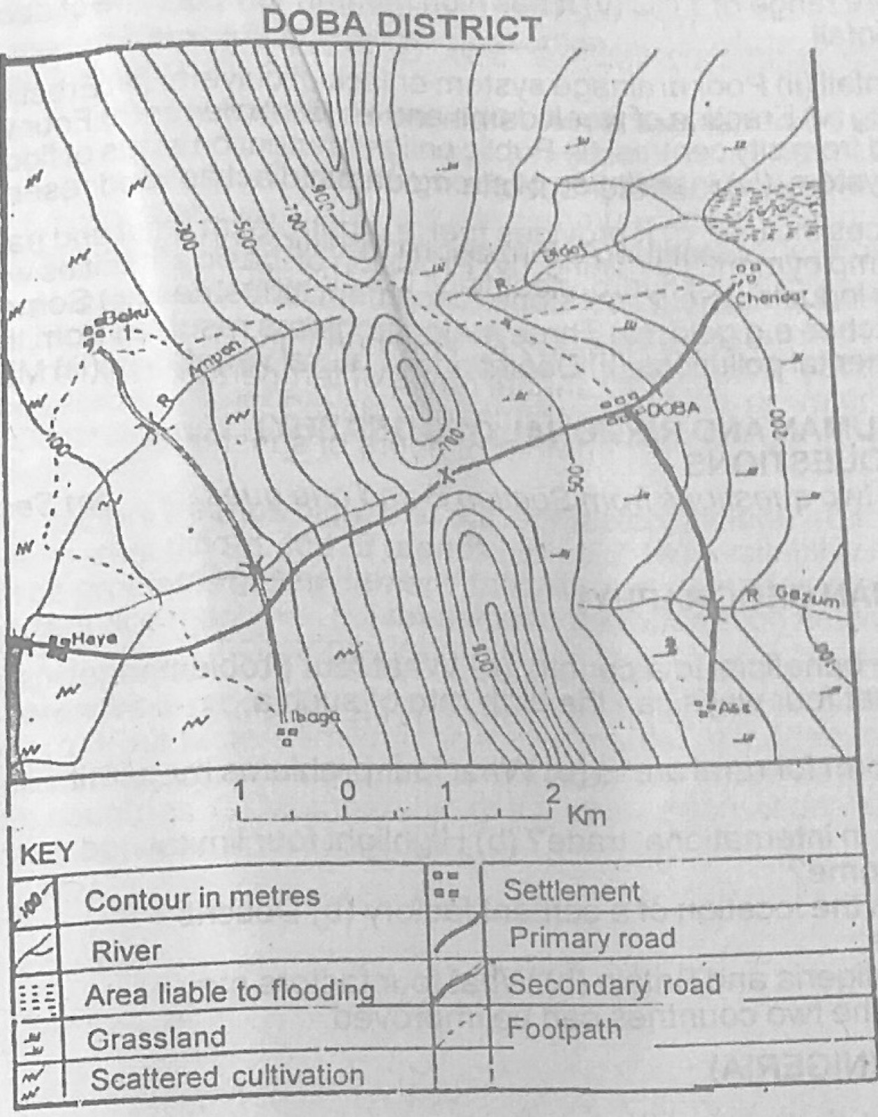
Use the map of DOBA DISTRICT to answer this question. The feature marked X is best described as a

Diagram for this question
  1. A.pass
  2. B.depression
  3. C.spur
  4. D.valley
  5. E.plateau
Show the answer and explanation

Answer: A (pass)

Explanation

X is the low point between two higher parts of the ridge, where the road crosses: a gap or pass.

Open this question

Question 5

Map Scale, Distance and Direction

Use the map of DOBA DISTRICT to answer this question. The distance from Baku to Ibaga along the secondary road is

Diagram for this question
  1. A.2.4km
  2. B.4.8km
  3. C.9.6km
  4. D.10.5km
  5. E.19.2km
Show the answer and explanation

Answer: B (4.8km)

Explanation

Measure the route along the road with a string and compare it with the linear scale; it comes to just under 5 km.

Open this question

Question 6

Relief and Map Interpretation

Use the map of DOBA DISTRICT to answer this question. The drainage pattern on the map is

Diagram for this question
  1. A.antecedent
  2. B.consequent
  3. C.dendritic
  4. D.trellis
  5. E.radial
Show the answer and explanation

Answer: E (radial)

Explanation

The rivers flow outwards in different directions away from the central high ground, which is a radial pattern.

Open this question

Question 7

Relief and Map Interpretation

Use the map of DOBA DISTRICT to answer this question. The direction of flow of River Bidol is

Diagram for this question
  1. A.south-eastward
  2. B.northwards
  3. C.westwards
  4. D.north-eastwards
  5. E.south-westwards
Show the answer and explanation

Answer: D (north-eastwards)

Explanation

Rivers flow from high to low ground; the river draining the north-eastern slope of the ridge flows away from it towards the north-east.

Open this question

Question 8

Relief and Map Interpretation

Use the map of DOBA DISTRICT to answer this question. Which of the following statements about the communication network on the map is correct? The routes

Diagram for this question
  1. A.link mineral producing areas
  2. B.run from north to south
  3. C.take advantage of low relief
  4. D.are predominant in the north
  5. E.are located on mountain tops
Show the answer and explanation

Answer: C (take advantage of low relief)

Explanation

The main road crosses the ridge through the pass at X and keeps to lower ground, so the routes take advantage of low relief.

Open this question

Question 9

Relief and Map Interpretation

Use the map of DOBA DISTRICT to answer this question. Which of the following settlements is linear?

Diagram for this question
  1. A.Baku
  2. B.Ase
  3. C.Chonda
  4. D.Doba
  5. E.Ibaga
Show the answer and explanation

Answer: D (Doba)

Explanation

Doba's buildings are strung out along the main road, which is a linear pattern.

Open this question

Question 10

Relief and Map Interpretation

Use the map of DOBA DISTRICT to answer this question. A crop likely to be produced in the lower valley of River Bidol is

Diagram for this question
  1. A.wheat
  2. B.rubber
  3. C.rice
  4. D.yam
  5. E.cocoyam
Show the answer and explanation

Answer: C (rice)

Explanation

Low valley floors that flood and stay wet suit rice, which grows in waterlogged soil.

Open this question

Question 11

The Earth and Solar System

The satellite of the earth is

  1. A.the sun
  2. B.Jupiter
  3. C.the moon
  4. D.Saturn
  5. E.Mars
Show the answer and explanation

Answer: C (the moon)

Explanation

The moon is the earth's only natural satellite; it revolves round the earth.

Open this question

Question 12

Latitude, Longitude and Time

The commentary of a football match which started at 1600 hours GMT in a town P(45°W) was heard in town Q at 2200 hours GMT. What is the longitude of Q?

  1. A.39°W
  2. B.45°E
  3. C.51°E
  4. D.90°W
  5. E.135°E
Show the answer and explanation

Answer: B (45°E)

Explanation

Taking the times as local times: P at 45°W is 3 hours behind Greenwich, so the match began at 1900 GMT; Q's time of 2200 is 3 hours ahead of GMT, and 3 × 15° = 45°E.

Open this question

Question 13

The Earth and Solar System

Which of the following statements about Jupiter is not true? it

  1. A.is the next planet to the Earth
  2. B.revolves round the sun
  3. C.is the only planet with twelve satellites
  4. D.is the largest planet in the solar system
  5. E.is about 773 million kms away from the sun
Show the answer and explanation

Answer: A (is the next planet to the Earth)

Explanation

Jupiter is the fifth planet from the sun; the planet next to the Earth (outwards) is Mars, so statement A is false.

Open this question

Question 14

Rocks

Igneous rocks contain

  1. A.humus
  2. B.fossils
  3. C.strata
  4. D.polyps
  5. E.crystals
Show the answer and explanation

Answer: E (crystals)

Explanation

Igneous rocks form when molten magma cools, and the minerals set as crystals; fossils and strata belong to sedimentary rocks.

Open this question

Question 15

Earth Movements and Vulcanicity

An active volcano is one that

  1. A.has not erupted recently
  2. B.will not erupt
  3. C.had earlier erupted violently
  4. D.erupts periodically
  5. E.has been very destructive
Show the answer and explanation

Answer: D (erupts periodically)

Explanation

An active volcano is one that still erupts from time to time.

Open this question

Question 16

Environmental Hazards and Conservation

The principal agents in soil erosion are

  1. A.wind and waves
  2. B.water and wind
  3. C.air and water
  4. D.water and dust
  5. E.drought and wind
Show the answer and explanation

Answer: B (water and wind)

Explanation

Running water (rain and run-off) and wind remove most topsoil.

Open this question

Question 17

Environmental Hazards and Conservation

Soil erosion leads to all the following except the

  1. A.loss of available plant nutrients
  2. B.loss of cultivable land
  3. C.loss of water reservoirs such as dams
  4. D.increasing drought condition
  5. E.increase in yield per hectare
Show the answer and explanation

Answer: E (increase in yield per hectare)

Explanation

Soil erosion removes fertile topsoil, so yields fall; it never increases them.

Open this question

Question 18

Rivers and River Landforms

The term watershed refers to the

  1. A.direction of flow of a river from its source to the sea
  2. B.volume of load carried by a river
  3. C.crestlines from which two or more rivers flow in opposite directions
  4. D.area drained by the main river and all its tributaries
  5. E.entire area flooded by a river during the wet season
Show the answer and explanation

Answer: C (crestlines from which two or more rivers flow in opposite directions)

Explanation

A watershed is the high ground or divide that separates rivers flowing in different directions.

Open this question

Question 19

Underground Water and Karst

A spring is an outlet for

  1. A.rivers
  2. B.streams in Karst regions
  3. C.underground water
  4. D.rain water in limestone regions
  5. E.volcanic lakes
Show the answer and explanation

Answer: C (underground water)

Explanation

A spring is where underground water comes out naturally at the surface.

Open this question

Question 20

Weathering, Erosion and Mass Movement

Which of the following represents the correct sequence in which denudation occurs?

  1. A.Weathering.... Erosion........ Deposition
  2. B.Depostion....... Weathering.... Erosion
  3. C.Erosion.... Weathering... Deposition
  4. D.Weathering...... Deposition....... Erosion
  5. E.Deposition.......Erosion.......Weathering
Show the answer and explanation

Answer: A (Weathering.... Erosion........ Deposition)

Explanation

Rock must first be broken down (weathering), then carried away (erosion), and finally laid down elsewhere (deposition).

Open this question

Question 21

Wind and Desert Landforms

Which of the following is a feature of erosion in arid regions?

  1. A.Caldera
  2. B.Barchan
  3. C.Yardang
  4. D.Pediment
  5. E.Outwash plain
Show the answer and explanation

Answer: C (Yardang)

Explanation

A yardang is a ridge of hard rock left standing after wind abrasion wears away softer bands; a barchan is a deposition feature.

Open this question

Question 22

Coastal Landforms

The water which is thrown against the beach by a breaking wave is called

  1. A.an undertow
  2. B.a backwash
  3. C.a fetch
  4. D.a swash
  5. E.a surf
Show the answer and explanation

Answer: D (a swash)

Explanation

The rush of water up the beach after a wave breaks is the swash; the water running back is the backwash.

Open this question

Question 23

Coastal Landforms

Which of the following features is not associated with coastal erosion?

  1. A.Bay
  2. B.Wave-cut platform
  3. C.Stack
  4. D.Geo
  5. E.Marine dune
Show the answer and explanation

Answer: E (Marine dune)

Explanation

Dunes are built by deposition of sand; bays, platforms, stacks and geos are cut by wave erosion.

Open this question

Question 24

Underground Water and Karst

A slender, downward growing pinnacle that hangs from a cave roof is a

  1. A.stalagmite
  2. B.grike
  3. C.stalactite
  4. D.clint
  5. E.doline
Show the answer and explanation

Answer: C (stalactite)

Explanation

A stalactite hangs down from the roof (c for ceiling); a stalagmite grows up from the floor.

Open this question

Question 25

Earth Movements and Vulcanicity

Lacustrine plains are formed

  1. A.on the bed of an old lake
  2. B.at the foot of a mountain
  3. C.in a rift valley
  4. D.on top of a plateau
  5. E.at the mouth of a river
Show the answer and explanation

Answer: A (on the bed of an old lake)

Explanation

Lacustrine means 'of a lake'; these plains are old lake beds exposed when the lake dries up or drains.

Open this question

Question 26

Rivers and River Landforms

All the following are ways in which rivers are useful to man except the

  1. A.formation of political boundaries between countries
  2. B.provision of rich agricultural land
  3. C.generation of hydro-electricity
  4. D.relocation of settlement after flooding
  5. E.promotion of trade and commerce
Show the answer and explanation

Answer: D (relocation of settlement after flooding)

Explanation

Having to move a settlement after a flood is a harm caused by rivers, not a use.

Open this question

Question 27

Climate

Which of the following is not a characteristic of the tropical desert climate?

  1. A.Low humidity
  2. B.Cloudless skies
  3. C.Dust haze
  4. D.Very high diurnal range of temperature
  5. E.Very low annual range of temperature
Show the answer and explanation

Answer: E (Very low annual range of temperature)

Explanation

Hot deserts have a fairly large annual range of temperature because of clear skies and dry air; a very low annual range belongs to the equatorial climate.

Open this question

Question 28

Weather

Which of the following factors is least important in determining the temperature of a place? The

  1. A.angle at which the sun's rays strike the earth's surface
  2. B.rate of transpiration
  3. C.number of hours of sunshine
  4. D.altitude above sea level
  5. E.amount of cloud cover
Show the answer and explanation

Answer: B (rate of transpiration)

Explanation

Sun angle, sunshine hours, altitude and cloud all control temperature strongly; plant transpiration has little effect.

Open this question

Question 29

Climate

The ancient Greeks classified the climates of the world into

  1. A.torrid, temperate and frigid zones
  2. B.hot, cold and medium zones
  3. C.torrid, equatorial and polar zones
  4. D.hot, mild and cool zones
  5. E.hot, moist and dry zones
Show the answer and explanation

Answer: A (torrid, temperate and frigid zones)

Explanation

The Greek classification, based on temperature, had three zones: torrid, temperate and frigid.

Open this question

Question 30

Vegetation

The tropical rainforest is characterised by all the following except

  1. A.a distinct layered arrangement
  2. B.multiple plant species
  3. C.evergreen trees
  4. D.little undergrowth
  5. E.tree with thorny leaves
Show the answer and explanation

Answer: E (tree with thorny leaves)

Explanation

Thorny leaves are an adaptation to drought found in dry savanna and desert plants, not in the wet rainforest.

Open this question

Question 31

Vegetation

Oak and cedar are good examples of commercial trees common in the

  1. A.equatorial vegetation
  2. B.Mediterranean vegetation
  3. C.Monsoon vegetation
  4. D.Tundra vegetation
  5. E.Desert vegetation
Show the answer and explanation

Answer: B (Mediterranean vegetation)

Explanation

Cork oak and cedar are typical trees of the Mediterranean forests.

Open this question

Question 32

Soils

The effect of humus in the soil is to make the soil

  1. A.retain more air
  2. B.retain more moisture
  3. C.sparkle
  4. D.very soft
  5. E.hard
Show the answer and explanation

Answer: B (retain more moisture)

Explanation

Humus is spongy organic matter that holds water, so soils rich in humus keep more moisture.

Open this question

Question 34

Soils

Heavy rainfall favours the formation of acid soils because it

  1. A.results in greater weathering of minerals
  2. B.causes more leaching of base elements
  3. C.results in capillary rise of base elements from deep below
  4. D.results in thicker vegetation cover
  5. E.increases bacterial activity in the soil
Show the answer and explanation

Answer: B (causes more leaching of base elements)

Explanation

Heavy rain washes bases such as calcium and potassium down and out of the soil (leaching), leaving it acidic.

Open this question

Question 35

The Ecosystem

The relationship between organisms in the ecosystem implies that the components

  1. A.are Interdependent
  2. B.share common ideas
  3. C.give birth to one another
  4. D.are enemies
  5. E.build one another
Show the answer and explanation

Answer: A (are Interdependent)

Explanation

In an ecosystem plants, animals and the environment depend on each other.

Open this question

Question 36

Environmental Hazards and Conservation

All the following are major pollutants of the environment except

  1. A.the flaring of gas in oil wells
  2. B.oil spillage
  3. C.industrial waste products
  4. D.domestic cooking
  5. E.combustion from vehicles
Show the answer and explanation

Answer: D (domestic cooking)

Explanation

Gas flaring, oil spills, industrial waste and vehicle exhaust are major pollution sources; domestic cooking is a minor one.

Open this question

Question 37

Settlement

Settlements can be classified according to all the following except the

  1. A.arrangement of the buildings
  2. B.number of people per settlement
  3. C.main occupation of the inhabitants
  4. D.number of buildings per unit area of land
  5. E.the type of people that live in the area
Show the answer and explanation

Answer: E (the type of people that live in the area)

Explanation

Settlements are classified by pattern (arrangement), size (population), function (main occupation) and density; the type of people living there is not a basis.

Open this question

Question 38

Settlement

When two separate towns grow and merge into one, the new settlement formed is called a

  1. A.conurbation
  2. B.megalopolis
  3. C.dormitory town
  4. D.metropolis
  5. E.satellite town
Show the answer and explanation

Answer: A (conurbation)

Explanation

A conurbation is formed when growing towns spread until they join.

Open this question

Question 39

Manufacturing Industry

All the following are examples of heavy industries except

  1. A.furniture making
  2. B.ship building
  3. C.refining of petroleum
  4. D.iron and steel
  5. E.aluminium smelting
Show the answer and explanation

Answer: A (furniture making)

Explanation

Furniture making uses light materials and small machines, so it is a light industry.

Open this question

Question 40

Environmental Resources

Which of the following is not a major problem of economic development in developing countries? Inadequate

  1. A.capital
  2. B.natural resources
  3. C.technical know-how
  4. D.transportation facilities
  5. E.infrastructure
Show the answer and explanation

Answer: B (natural resources)

Explanation

Most developing countries have plenty of natural resources; their problems are shortage of capital, skills, transport and infrastructure.

Open this question

Question 41

Nigeria: Physical Setting

Jos has a heavier rainfall than the other towns on the same latitude in Nigeria because it

  1. A.has lower temperatures
  2. B.is located on the windward side of a plateau
  3. C.is located near the coast
  4. D.is located on the path of descending winds
  5. E.is located in the equatorial region
Show the answer and explanation

Answer: B (is located on the windward side of a plateau)

Explanation

Moist south-west winds are forced to rise over the Jos Plateau, cool and give relief (orographic) rain.

Open this question

Question 42

Nigeria: People and Economy

The most important area for lumbering in Nigeria is found in the

  1. A.Benin-Obudu-Yola region
  2. B.Ibadan-Benin-Port Harcourt region
  3. C.Lagos-Port Harcourt-Calabar region
  4. D.Minna-Lokoja-Makurdi region
  5. E.Chad Basin
Show the answer and explanation

Answer: B (Ibadan-Benin-Port Harcourt region)

Explanation

Lumbering is concentrated in the high forest belt of the south, stretching from Ibadan through Benin to the Port Harcourt area.

Open this question

Question 43

Nigeria: People and Economy

Jebba, Lokoja and Onitsha are examples of

  1. A.packet stations
  2. B.railway stations
  3. C.sea ports
  4. D.river ports
  5. E.entrepots
Show the answer and explanation

Answer: D (river ports)

Explanation

All three towns stand on the River Niger and handle river traffic, so they are river ports.

Open this question

Question 44

Nigeria: People and Economy

Which of the following is true of manufacturing industries in Nigeria?

  1. A.Most of them produce consumer goods
  2. B.Large quantities of their products are exported
  3. C.They depend totally on local raw materials
  4. D.They were established in pre-colonial times
  5. E.They are evenly distributed throughout the country
Show the answer and explanation

Answer: A (Most of them produce consumer goods)

Explanation

Most Nigerian factories make consumer goods such as food, drinks, soap and textiles for the home market.

Open this question

Question 47

Geography of Africa

Africa is threatened today by serious soil erosion because the

  1. A.soils are porous
  2. B.landscape is characterised by mountains
  3. C.rainfall is heavy all over Africa
  4. D.soils are recklessly exposed
  5. E.agents of erosion are very active
Show the answer and explanation

Answer: D (soils are recklessly exposed)

Explanation

Bush burning, overgrazing, deforestation and poor farming leave the soil bare, so rain and wind carry it away.

Open this question

Question 48

Geography of Africa

The largest irrigation scheme in Africa is served by the

  1. A.Sennar Dam
  2. B.Kainji Dam
  3. C.Akosombo Dam
  4. D.Tiga Dam
  5. E.Kariba Dam
Show the answer and explanation

Answer: A (Sennar Dam)

Explanation

The Gezira scheme in Sudan, the largest in Africa, gets its water from the Blue Nile at the Sennar Dam.

Open this question

Question 49

Geography of Africa

Which of the following vegetation belts in Africa is usually associated with the tropical continental climate?

  1. A.Tropical desert
  2. B.Sudan Savanna
  3. C.Guinea Savanna
  4. D.Tropical rainforest
  5. E.Tropical monsoon forest
Show the answer and explanation

Answer: B (Sudan Savanna)

Explanation

The tropical continental (savanna) climate with a long dry season supports savanna grassland, typically the Sudan savanna.

Open this question

Question 50

Geography of Africa

Which of the following lakes is not found in the East African Rift Valley?

  1. A.Lake Turkana
  2. B.Lake Tanganyika
  3. C.Lake Mweru
  4. D.Lake Mobutu
  5. E.Lake Tana
Show the answer and explanation

Answer: E (Lake Tana)

Explanation

Lake Tana lies on the Ethiopian Plateau and was formed by lava damming, not by rifting; Turkana, Tanganyika and Mobutu (Albert) lie in the rift valleys.

Open this question

Theory question 101

Population

(a) Explain four ways in which a fall in birth rate can be beneficial to a country (b) What four problems can arise from a fall in the birth rate of a country? (c) In what four ways can the birth rate of such a country be increased?

Show the model answer
Model answer

(a) Less pressure on food, housing, schools and health care; higher income per head and better living standards; more savings and investment; less unemployment; less pressure on land and the environment.
(b) Ageing population; shortage of labour in future; smaller domestic market; fewer people for defence; heavier burden of caring for the old; possible decline of the population.
(c) Incentives such as child allowances and tax relief; free education and health care for children; maternity leave and benefits; discouraging family-planning campaigns; encouraging early marriage; improving housing.

Explanation

Each part needs four separate points explained.

Open this question

Theory question 102

Settlement

(a) Explain any five functions which urban centres perform for rural areas (b) What four problems may limit the performance of the functions identified in (a) above

Show the model answer
Model answer

(a) Market for rural produce; supply of manufactured goods; services such as hospitals, schools and banks; jobs for rural migrants; administrative services; transport and communication centre; source of information and new ideas.
(b) Poor roads and transport; distance between town and villages; high cost of services; inadequate facilities in the towns (overcrowding); poverty of rural people; poor information flow.

Explanation

Think of what villagers go to town for.

Open this question

Theory question 103

Transport, Trade and Tourism

(a) In what fours ways is water transportation important in international trade? (b) Highlight four limitations of water transpiration (c) How can these limitations be overcome?

Show the model answer
Model answer

(a) Cheapest way to carry bulky goods over long distances; carries the largest volume of world trade; links continents; handles heavy goods like oil, ores and grain; supports ports and jobs.
(b) Slow; restricted to waterways and coasts; seasonal low water, rapids and ice; silting of channels and ports; storms and piracy; needs costly port facilities.
(c) Dredging channels; building canals and locks; building dams to regulate flow; modern faster ships and containerisation; improved navigation aids and weather forecasts; better port facilities and security.

Explanation

The stem's 'transpiration' is a misprint for transportation.

Open this question

Theory question 104

Manufacturing Industry

(a) Explain any five factors that should be considered in the location of a cement factory (b) Describe any three problems facing cement factories in Tropical Africa

Show the model answer
Model answer

(a) Nearness to raw materials (limestone, clay, gypsum); power supply; water supply; market; transport; capital; labour; government policy; land.
(b) Shortage of spare parts and machinery breakdowns; erratic power supply; poor transport for distribution; high cost of production and imported inputs; competition from imported cement; dust pollution; poor management.

Explanation

Limestone is bulky and heavy, so factories are sited near it.

Open this question

Theory question 105

Transport, Trade and Tourism

(a) Account for the inter-dependence in trade between Nigeria and Britain (b) What four factors may limit this trade? (c) State three ways by which the trade between the two countries can be improved

Show the model answer
Model answer

(a) Colonial ties and common language; Nigeria exports raw materials (crude oil, cocoa, rubber) Britain needs; Britain exports manufactured goods (machinery, vehicles, chemicals) Nigeria needs; Commonwealth membership; established banking and shipping links.
(b) Fall in prices of primary products; trade restrictions and tariffs; foreign exchange shortages; competition from other countries; political problems; poor quality of some exports.
(c) Trade agreements and lower tariffs; diversifying and processing exports; improving quality of goods; trade fairs and missions; stable policies.

Explanation

Interdependence means each country needs what the other produces.

Open this question

Theory question 106

Nigeria: Physical Setting

(a) On an outline map of Nigeria, locate and name (i) an inland drainage basin (ii) a delta (iii) a man-made lake (iv) a confluence town (b) In what four ways can physical factors limit the use of rivers for transportation in Nigeria? (c) How can these limitations be overcome?

Show the model answer
Model answer

(a) Map: Chad Basin (north-east); Niger Delta (south); Kainji Lake (or Shiroro/Jebba) on the Niger; Lokoja at the Niger-Benue confluence; title, key and frame.
(b) Seasonal fall in water level in the dry season; rapids and waterfalls; sandbars and silting; floating vegetation (water hyacinth); meandering courses; rocky beds.
(c) Dredging; building dams and locks; clearing weeds; canalisation; building good river ports.

Explanation

Mark each feature in its correct position on the map.

Open this question

Theory question 107

Nigeria: Physical Setting

(a) Draw an outline map of Nigeria and on it, show and name (i) the savanna belts and one important town in each of the belts (b) Highlight three vegetation characteristics of any one of the savanna belts shown on your map (c) Describe the relationship between vegetation and rainfall in the savanna belts.

Show the model answer
Model answer

(a) Map showing Guinea savanna (e.g. Ilorin, Minna, Makurdi), Sudan savanna (e.g. Kano, Sokoto) and Sahel savanna (e.g. Nguru, Maiduguri area) from south to north.
(b) e.g. Guinea savanna: tall grasses up to 3 m; scattered trees with umbrella crowns; deciduous trees; gallery forests along rivers; thick bark and long roots.
(c) Rainfall decreases northward, so vegetation becomes shorter and sparser; tall grass and more trees where rain is heavier; short grass and thorny shrubs where rain is low; length of dry season decides how long the grass stays green.

Explanation

Show the belts as bands across the map from south to north.

Open this question

Theory question 108

Nigeria: People and Economy

Give reasons for any three of the following in Nigeria (a) Market gardening is predominantly practised around major urban areas (b) Lumbering is practised mainly in the high forest belt (c) Rice is cultivated in large quantity in the Middle Belt (d) Cattle rearing is important in the Sudan Savanna Belt.

Show the model answer
Model answer

(a) Large market for vegetables; produce is perishable so must be near consumers; high prices make small plots profitable; good transport; water from streams/wells.
(b) Large stands of valuable hardwood trees (mahogany, iroko, obeche); heavy rainfall supports tall trees; rivers for floating logs; sawmills and ports nearby.
(c) Wide flood plains of the Niger and Benue; fertile alluvial soils; adequate water for irrigation; irrigation schemes (e.g. Bida, Badeggi); large market.
(d) Grass for pasture; freedom from tsetse fly; dry climate; Fulani pastoral tradition; open land; markets.

Explanation

Answer any three; give three or four reasons for each.

Open this question

Theory question 109

Nigeria: Physical Setting

(a) On an outline map of Nigeria, locate and name the (i) North-Central Highlands, Western Highlands, Adamawa Highlands and Udi Hills (ii) Rivers Sokoto, Gongola, Oshun and Anambra (b) Describe four ways in which the North-Central Highlands are of economic importance (c) Highlight any four problems limiting the economic development of the region

Show the model answer
Model answer

(a) Map placing the North-Central (Jos) Highlands in the centre, Western Highlands in the south-west, Adamawa Highlands on the eastern border, Udi Hills in the south-east; rivers Sokoto (north-west), Gongola (north-east), Oshun (south-west), Anambra (south-east).
(b) Tin and columbite mining around Jos; cool climate for tourism and temperate crops (potatoes, vegetables); source of rivers for HEP and irrigation; cattle rearing free of tsetse; hill resorts.
(c) Soil erosion and mining pits; rugged relief making transport hard; poor soils; decline of tin mining; shortage of water in the dry season; inadequate capital.

Explanation

Locate each item accurately; then give economic uses and problems.

Open this question

Theory question 110

Nigeria: Physical Setting

(a) On an outline map of Nigeria locate and name: (i) the Eastern Highlands, Eastern Scarplands and Chad Basin (ii) one important river in each region (iii) one important town in each region (b) Describe the Eastern Highlands under the following headings: (i) population and settlement (ii) natural resources (iii) economic activities

Show the model answer
Model answer

(a) Eastern Highlands along the eastern border (Obudu, Mambilla), river Cross/Donga, town Obudu; Eastern Scarplands (Udi-Nsukka), river Anambra/Imo, town Enugu; Chad Basin (north-east), river Yobe, town Maiduguri.
(b)(i) Sparse population; small dispersed and hill-top settlements; denser on the plateaux tops.
(ii) Forest and grassland, waterfalls and rivers, cool climate, scenery, some minerals.
(iii) Crop farming (tea on Mambilla, food crops); cattle rearing on Obudu and Mambilla; tourism (Obudu Cattle Ranch); lumbering.

Explanation

Keep regions in the right positions: highlands on the eastern border.

Open this question

Theory question 111

West Africa and ECOWAS

(a) Draw an outline map of West Africa and on it show and name: (i) any three member countries of the ECOWAS (ii) the capitals of the countries shown (b) Outline any three objectives of the ECOWAS (c) Explain three factors that have limited the full attainment of these objectives

Show the model answer
Model answer

(a) Map with e.g. Nigeria (Abuja), Ghana (Accra), Senegal (Dakar).
(b) Promote trade among members; free movement of people, goods and services; economic co-operation and development; common external tariff; improved transport and communication links; raise living standards.
(c) Different currencies; language barriers (English, French, Portuguese); similar products limiting trade; political instability; poor transport links; loyalty to former colonial powers; smuggling.

Explanation

Name real ECOWAS members and their present capitals.

Open this question

Theory question 112

Geography of Africa

(a) Draw a sketch map of Africa and on it, show and name (i) the Fouta D'jallon Highlands and the Cameroun Highlands (ii) one important river that takes its source from each highland (iii) one important inland drainage basin of Africa (iv) one artificial lake (v) one lagoon coast (b) Highlight three ways in which river basins are important to the economy of Africa (c) Describe any three major characteristics of the coastline of Africa

Show the model answer
Model answer

(a) Map: Fouta Djallon (Guinea) with R. Niger (or Senegal, Gambia); Cameroon Highlands with R. Benue (or Sanaga); inland basin e.g. Chad Basin or Okavango; artificial lake e.g. Volta, Kariba, Kainji, Nasser; lagoon coast e.g. Lagos to Abidjan stretch of the Gulf of Guinea.
(b) Fertile soils for farming and irrigation; water supply; HEP; fishing; transport; sites for settlement.
(c) Smooth with few indentations; few natural harbours; narrow continental shelf; sandbars and lagoons in West Africa; deltas (Nile, Niger); steep coasts where plateaux reach the sea.

Explanation

Place highlands and rivers correctly; Niger rises in Fouta Djallon, Benue in Cameroon.

Open this question

Theory question 113

Climate

Describe how each of the following factors affects the climate of Africa (a) Latitude (b) Ocean currents (c) Distance from the sea

Show the model answer
Model answer

(a) Africa lies mostly within the tropics so temperatures are high; near the equator sun is overhead twice a year giving high heat and rain all year; climates change towards the north and south (savanna, desert, Mediterranean).
(b) Warm currents (Guinea, Mozambique, Agulhas) raise coastal temperatures and bring rain; cold currents (Canary, Benguela) cool coasts, give fog and dry air, helping form the Sahara and Namib deserts.
(c) Coastal areas have moderate temperatures, smaller ranges and more rain/humidity; interior places have extreme temperatures, bigger ranges and less rain (continentality).

Explanation

Give examples for each factor.

Open this question

Theory question 114

Geography of Africa

(a) On a sketch map of Africa, show and name: (i) two areas important for a named fuel mineral, each in a different country (ii) two areas important for a named metallic mineral, each in a different country (iii) one major town in each area (b) Highlight any fours problems facing mining in Africa

Show the model answer
Model answer

(a) e.g. Petroleum: Niger Delta, Nigeria (Port Harcourt); Hassi Messaoud, Algeria; or coal at Enugu and Wankie. Metallic mineral: copper in the Zambian Copperbelt (Kitwe) and Katanga/Shaba, DR Congo (Lubumbashi); or gold at the Witwatersrand (Johannesburg) and Obuasi, Ghana.
(b) Shortage of capital; lack of skilled labour; poor transport; fluctuating world prices; foreign control; environmental damage; political instability; exhaustion of deposits.

Explanation

Name the mineral and towns correctly.

Open this question

Theory question 115

Geography of Africa

(a) Describe any four factors which have favoured the development of plantation agriculture in East Africa (b) State any four ways in which plantation agriculture is important to the economy of the region (c) Outline any four problems facing this system of agriculture in the region

Show the model answer
Model answer

(a) Fertile volcanic soils; cool highland climate with good rainfall; large areas of land; cheap labour; capital and skills from European settlers/companies; railway and ports (Mombasa); world demand.
(b) Foreign exchange from tea, coffee, sisal; employment; raw materials for industry; government revenue; development of infrastructure; settlement growth.
(c) Pests and diseases; fluctuating world prices; labour shortages and disputes; soil exhaustion; poor transport in some areas; foreign ownership and land disputes.

Explanation

Examples: tea in Kericho, coffee in Kenyan Highlands, sisal in Tanzania.

Open this question

Theory question 202

Structure of the Earth

(a)(i) Draw a well labelled diagram to show the internal structure of the earth (ii) Describe the distinguishing characteristics of any one of the layers shown in your diagram (b) Outline the importance of either the hydrosphere or the biosphere to man

Show the model answer
Model answer

(a)(i) Diagram: concentric layers labelled crust (lithosphere), mantle, outer core and inner core; crust shown thin; title and labels.
(ii) e.g. Crust: thin outer layer 5-70 km thick; continental part (SIAL, granite, silica and aluminium, density about 2.7) and oceanic part (SIMA, basalt, silica and magnesium, density about 3.0); solid; holds all landforms. (Or mantle / core with thickness, composition, state, temperature.)
(b) Hydrosphere: water for domestic, industrial and farm use; fish and other food; water transport; HEP; minerals and salt from the sea; moderates climate; recreation.
Or Biosphere: food from plants and animals; timber and fuel; raw materials (rubber, cotton); medicines; oxygen; soil fertility; tourism.

Explanation

Draw the layers in correct order from the outside in, then describe one layer fully.

Open this question

Theory question 203

Oceans and Lakes

(a) Highlight the economic importance of oceans to man, giving specific examples (b) Select any one warm current in the North Atlantic Ocean and describe the factors responsible for its movement

Show the model answer
Model answer

(a) Ocean transport for world trade (e.g. Atlantic routes); fishing (e.g. North Sea, Grand Banks); minerals such as petroleum on the continental shelf (Niger Delta, North Sea) and salt; tourism and recreation; employment; moderating coastal climates; source of rainfall.
(b) e.g. Gulf Stream / North Atlantic Drift: driven by the prevailing winds (trade winds push water west, westerlies push it north-east); deflection by the earth's rotation (Coriolis force) to the right; differences in temperature and density between warm and cold water; differences in salinity; shape of coastlines turning the current.

Explanation

Name one warm current (Gulf Stream, North Atlantic Drift) and link each factor to its direction.

Open this question

Theory question 204

Climate

(a)(i) Name the three climatic belts recognised by the Greek system of classification (ii) What is the basis of this classification? (b) State one characteristic of each of the recognised belts (c) What three advantages has the Koppen's classification over the Greek system?

Show the model answer
Model answer

(a)(i) Torrid, temperate and frigid zones. (ii) Temperature (latitude/sun's heat).
(b) Torrid: hot all year, between the tropics. Temperate: warm summers and cool/cold winters, marked seasons. Frigid: very cold all year, polar regions.
(c) Koppen uses both temperature and rainfall; it uses measured numerical values; it has many more types and sub-types so it is more detailed; it relates climate to vegetation; it is widely used.

Explanation

Remember the Greek system used temperature alone.

Open this question

Theory question 205

Vegetation

(a) Highlight the distinguishing characteristics of the natural vegetation associated with either the cool temperate (eastern margin type) or the tropical continental climate (b) Explain the factors that have aided the occurrence of the vegetation type in the area you have selected.

Show the model answer
Model answer

Tropical continental (savanna): (a) mainly tall grasses (elephant grass in the wetter parts, shorter tufted grass in the drier parts); scattered trees such as baobab, shea butter and acacia; deciduous trees that shed leaves in the dry season; long tap roots, thick bark, thorny or small leaves; grass dries up in the dry season and grows again in the rains.
(b) Seasonal rainfall (about 500-1500 mm) with a long dry season; high temperatures all year; frequent bush burning and grazing; soils that are lateritic and leached.
Cool temperate eastern margin: deciduous and mixed forest (oak, beech, maple), leaves shed in winter, few species per area; factors: rain all year, warm summers, cold winters.

Explanation

Choose one climate and match each vegetation feature to a climate cause.

Open this question

Theory question 206

Environmental Hazards and Conservation

(a) Describe five causes of flooding (b) In what four ways can flooding be controlled?

Show the model answer
Model answer

(a) Very heavy or long-lasting rainfall; blocked or poor drainage channels (refuse dumping); building on flood plains and waterways; clearing of vegetation so run-off increases; collapse or release of water from dams; rising sea level / storm surges along coasts; melting snow.
(b) Building dams and reservoirs; dredging and channelising rivers; building good drainage and culverts; planting trees (afforestation); banning building on flood plains; levees and embankments; public enlightenment on refuse disposal.

Explanation

Give five causes and four distinct control measures.

Open this question

Theory question 207

Environmental Resources

(a) Describe the significance of minerals as an environmental resource (b) Highlight three major problems resulting from the exploitation of mineral resources

Show the model answer
Model answer

(a) Source of fuel and power (petroleum, coal, gas); raw materials for industry (limestone for cement, iron ore); foreign exchange from exports; government revenue; employment; growth of towns and infrastructure (e.g. Jos, Enugu); jewellery and ornaments (gold).
(b) Pollution of land, water and air (oil spills, dust); destruction of farmland and vegetation; land degradation such as mining pits and erosion; health hazards and accidents; displacement of people.

Explanation

Point (a) is about uses; point (b) about harm to the environment and people.
Open this question