WAEC Geography 2007 past questions and answers

63 questions. Try each one, then open the answer to check yourself and read the explanation.

Question 1

Relief and Map Interpretation

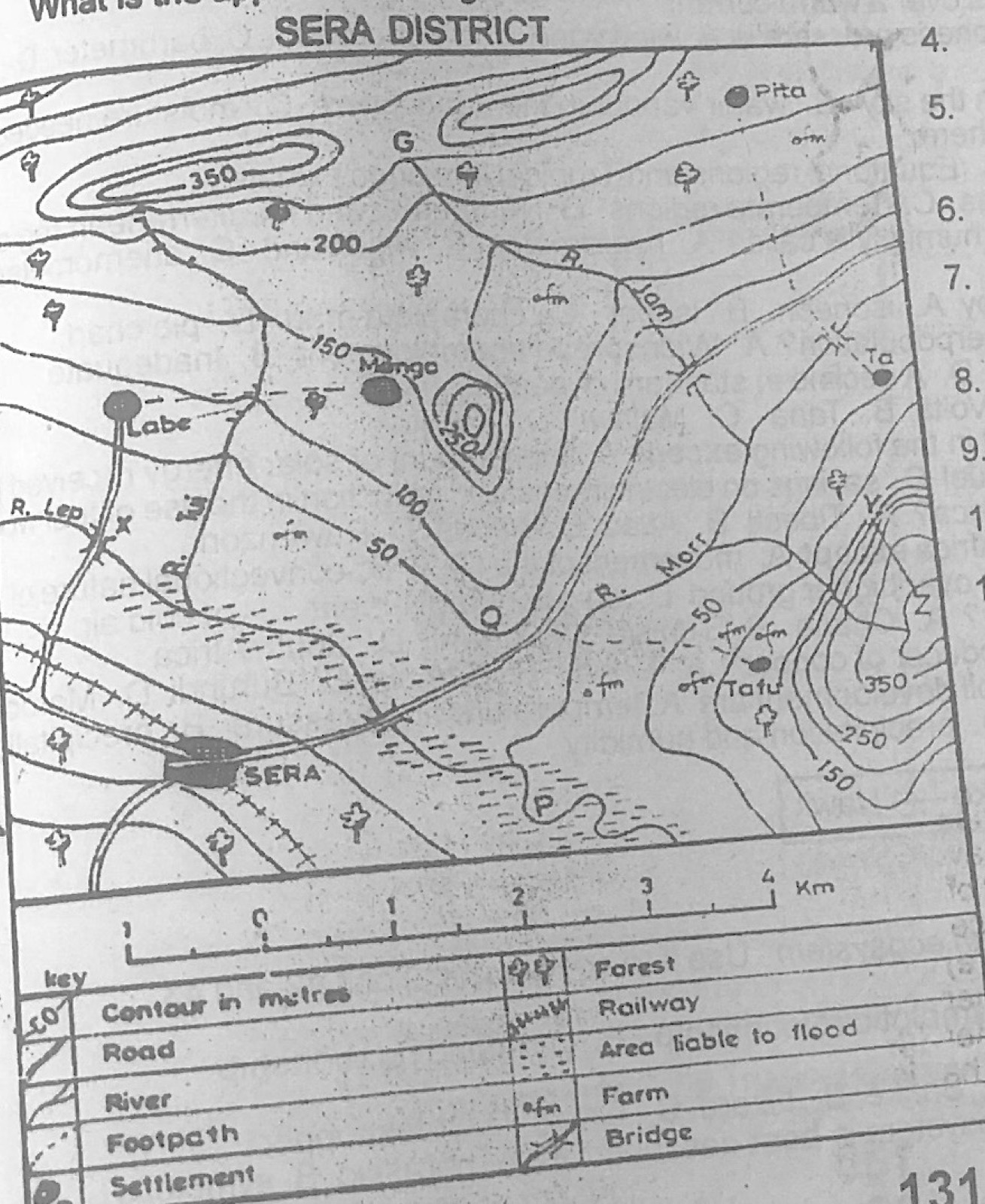
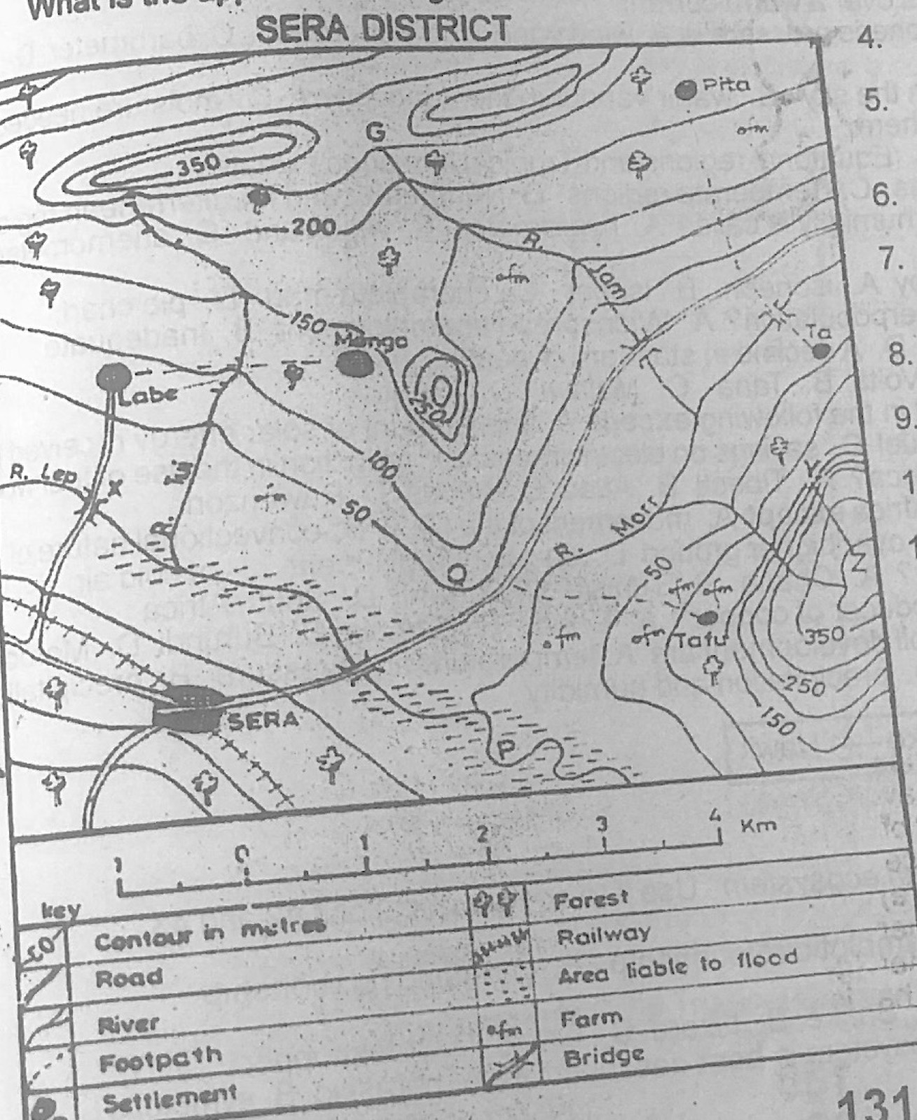
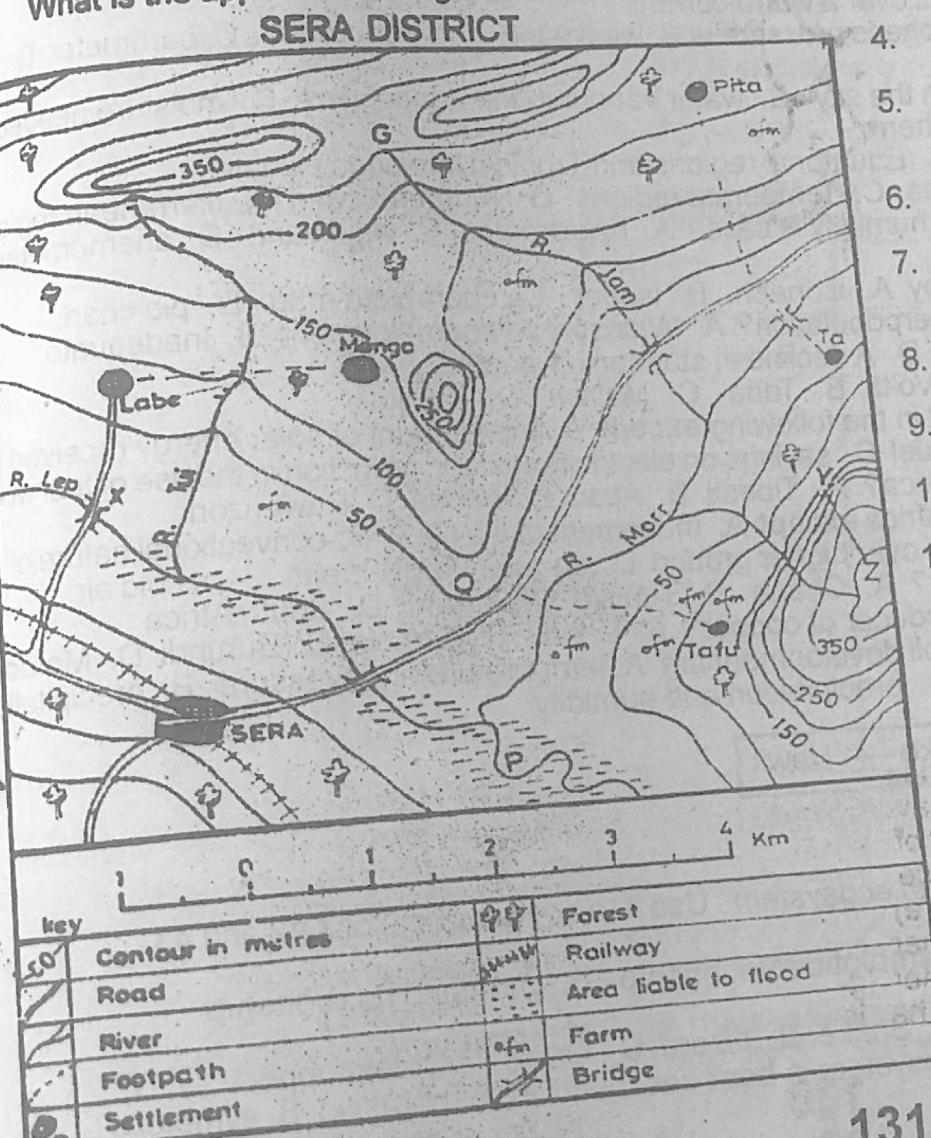
Study the map of SERA DISTRICT to answer this question. The feature marked G on the map represents a

Diagram for this question
  1. A.cuesta
  2. B.mountain
  3. C.slope
  4. D.saddle.
Show the answer and explanation

Answer: D (saddle.)

Explanation

G is a low dip on the high ground between two hill tops (both ringed by the 350 m contour): a saddle.

Open this question

Question 2

Relief and Map Interpretation

Study the map of SERA DISTRICT to answer this question. The feature marked Y – Z is known as

Diagram for this question
  1. A.plateau
  2. B.hanging valley
  3. C.convex slope
  4. D.dip slope.
Show the answer and explanation

Answer: C (convex slope)

Explanation

From Y to Z the contours are close together near the bottom and wider apart near the top, so the slope is steep below and gentle above: convex.

Open this question

Question 4

Relief and Map Interpretation

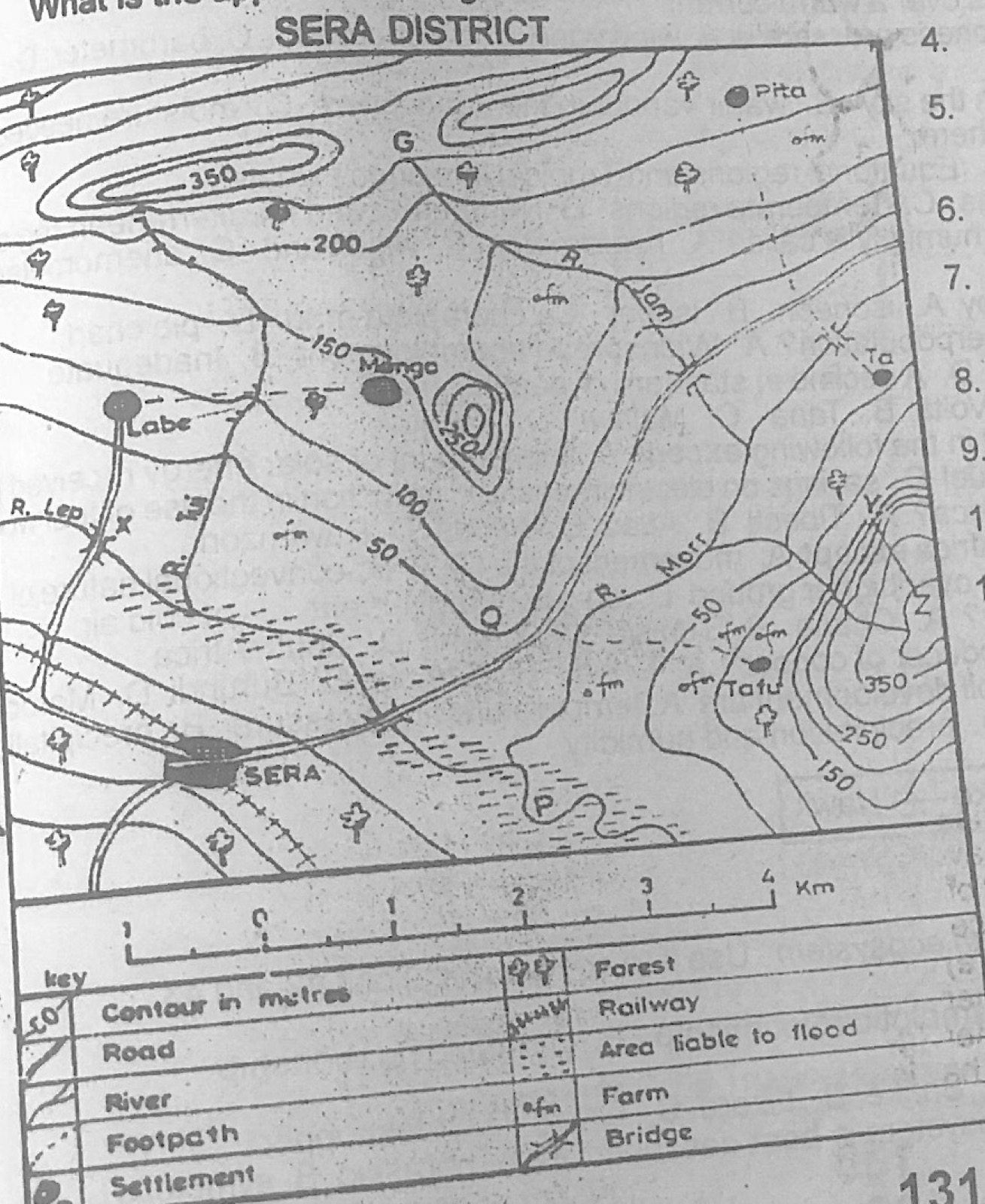
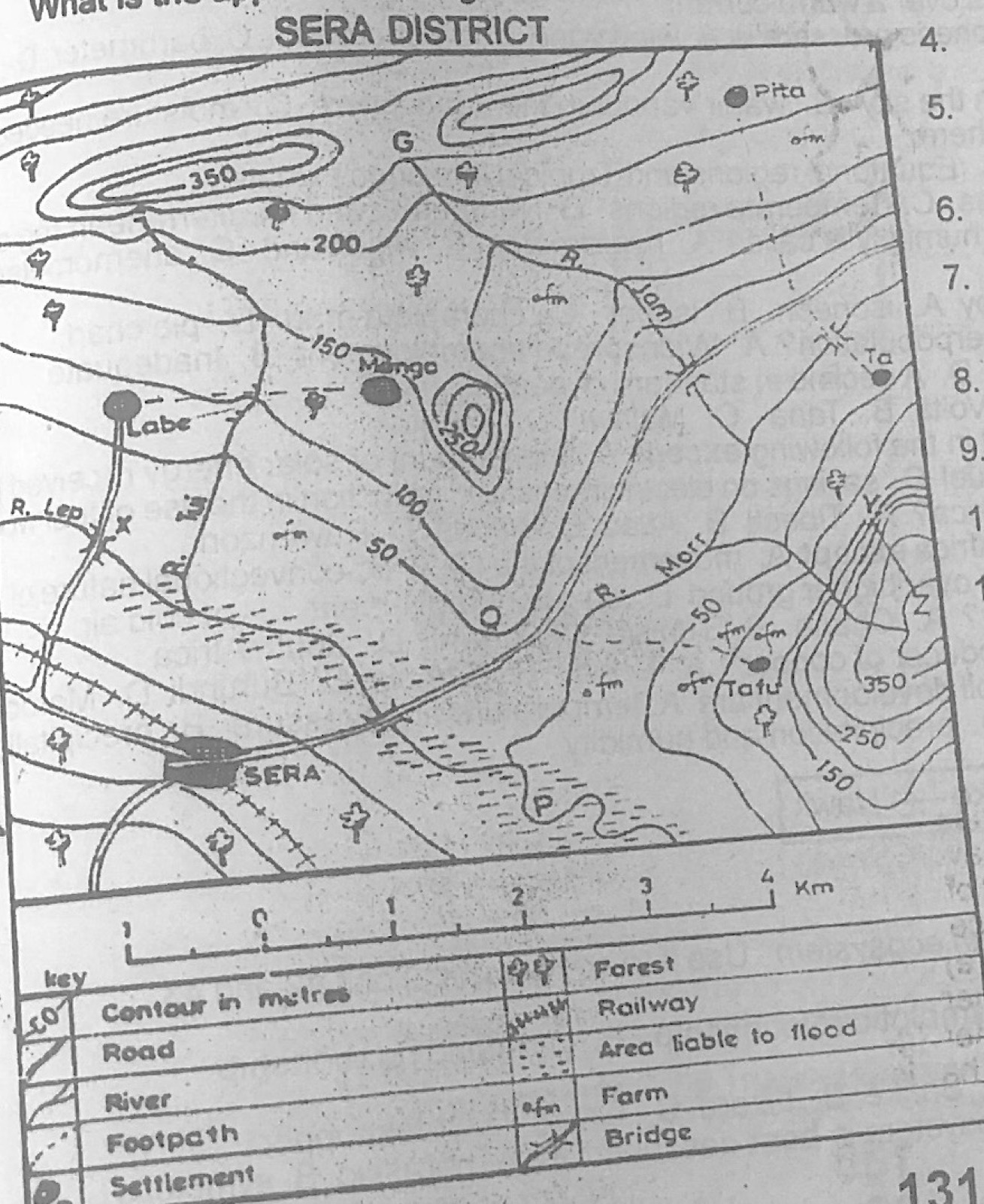
Study the map of SERA DISTRICT to answer this question. The highest point on the map is a little above

Diagram for this question
  1. A.250 m
  2. B.300 m
  3. C.400 m
  4. D.500 m.
Show the answer and explanation

Answer: C (400 m)

Explanation

The hill in the south-east has closed contours inside the 350 m line (interval 50 m), so its top is a little above 400 m.

Open this question

Question 5

Relief and Map Interpretation

Study the map of SERA DISTRICT to answer this question. River Lep flows from

Diagram for this question
  1. A.West to South East
  2. B.North West to South West
  3. C.South to West
  4. D.North East to South West.
Show the answer and explanation

Answer: A (West to South East)

Explanation

River Lep enters from the western edge and flows south-eastwards towards the flood plain near Sera.

Open this question

Question 6

Relief and Map Interpretation

Study the map of SERA DISTRICT to answer this question. SERA may be described as a

Diagram for this question
  1. A.fishing town
  2. B.coastal town
  3. C.nodal town
  4. D.gap town.
Show the answer and explanation

Answer: C (nodal town)

Explanation

Several roads and the railway meet at Sera, making it a nodal town.

Open this question

Question 7

Relief and Map Interpretation

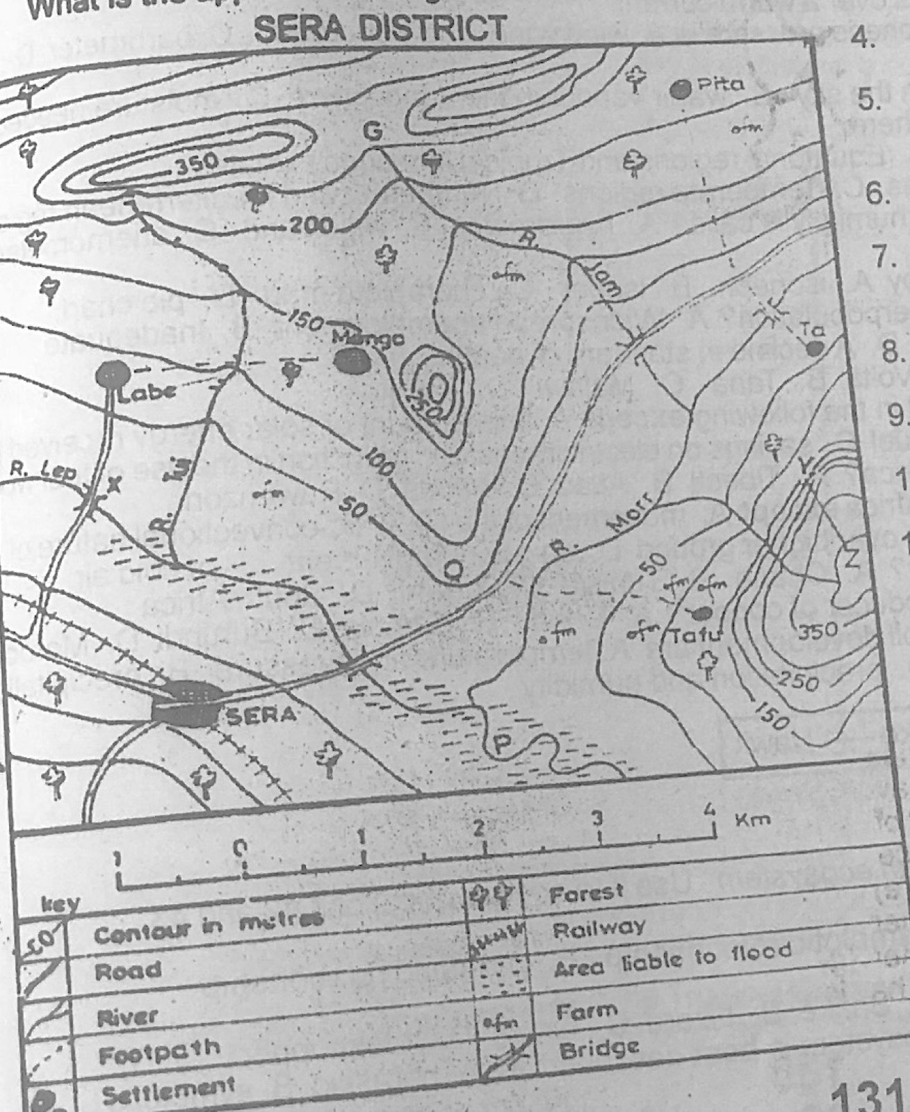
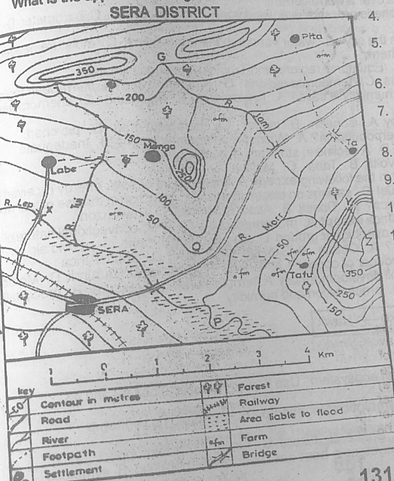
Study the map of SERA DISTRICT to answer this question. Which of the following towns are not intervisible?

Diagram for this question
  1. A.Labe and Mongo
  2. B.Sera and Tafu
  3. C.Sera and Pita
  4. D.Ta and Pita.
Show the answer and explanation

Answer: C (Sera and Pita)

Explanation

The high ground (over 350 m) in the north lies between Sera and Pita and blocks the view.

Open this question

Question 8

Map Scale, Distance and Direction

Study the map of SERA DISTRICT to answer this question. What is the approximate bearing of Labe from Mongo?

Diagram for this question
  1. A.20°
  2. B.40°
  3. C.190°
  4. D.270°
Show the answer and explanation

Answer: D (270°)

Explanation

Labe lies almost due west of Mongo, so its bearing is about 270°.

Open this question

Question 9

Relief and Map Interpretation

Study the map of SERA DISTRICT to answer this question. The feature marked Q is a

Diagram for this question
  1. A.conical hill
  2. B.cliff
  3. C.knoll
  4. D.spur.
Show the answer and explanation

Answer: D (spur.)

Explanation

At Q the contours form a tongue pointing down towards the river: a spur.

Open this question

Question 10

Relief and Map Interpretation

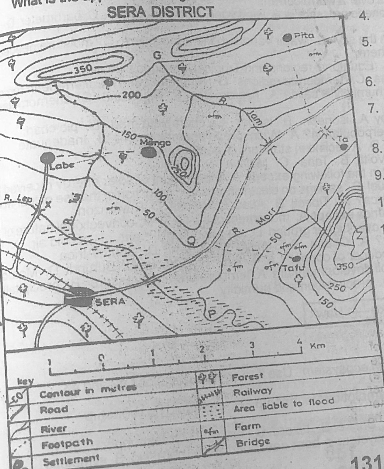
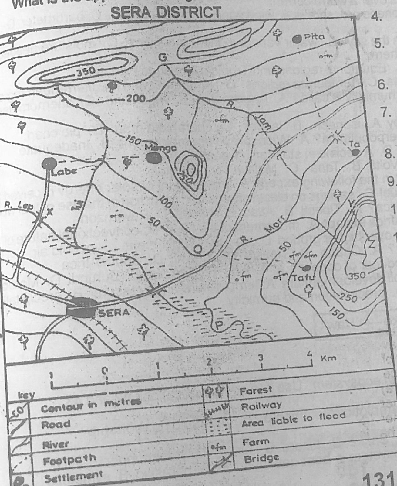
Study the map of SERA DISTRICT to answer this question. The relief feature marked P is a

Diagram for this question
  1. A.meander
  2. B.Cliff
  3. C.confluence
  4. D.broad valley.
Show the answer and explanation

Answer: A (meander)

Explanation

At P the river swings in a series of loops: a meander.

Open this question

Question 11

The Earth and Solar System

Which of the following does not prove that the earth is spherical in shape?

  1. A.Tilting of the earth on its axis
  2. B.The curved horizon of the earth
  3. C.The eclipse of the moon
  4. D.Aerial photographs of the earth taken by astronauts.
Show the answer and explanation

Answer: A (Tilting of the earth on its axis)

Explanation

The tilt of the axis causes seasons; it is not evidence of the earth's round shape.

Open this question

Question 12

The Earth and Solar System

During the equinoxes

  1. A.there are 6 hours of darkness and 18 hours of daylight in the Northern Hemisphere
  2. B.there is complete darkness for 24 hours at the North Pole
  3. C.there is continuous daylight for 24 hours at the South Pole
  4. D.days and nights are equal in length for all places throughout the world.
Show the answer and explanation

Answer: D (days and nights are equal in length for all places throughout the world.)

Explanation

At the equinoxes the overhead sun is at the equator, so every place has 12 hours of day and 12 of night.

Open this question

Question 13

The Earth and Solar System

The movement of the earth round the sun is termed the earth's

  1. A.evolution
  2. B.revolution
  3. C.rotation
  4. D.orbit.
Show the answer and explanation

Answer: B (revolution)

Explanation

Moving round the sun is revolution; spinning on the axis is rotation.

Open this question

Question 14

The Earth and Solar System

Seasonal changes in weather and climate are caused by

  1. A.rotation of the earth on its axis
  2. B.direct overhead sun on the Tropic of Cancer
  3. C.direct overhead sun on the Tropic of Capricorn
  4. D.revolution of the earth round the sun.
Show the answer and explanation

Answer: D (revolution of the earth round the sun.)

Explanation

As the tilted earth revolves round the sun, the overhead sun shifts between the tropics, bringing the seasons.

Open this question

Question 15

Latitude, Longitude and Time

What is the distance between Accra, Latitude 5°30 N and London, Latitude 51°30 N?

  1. A.5,406 km
  2. B.5.306 km
  3. C.5,216 km
  4. D.5,106 km.
Show the answer and explanation

Answer: D (5,106 km.)

Explanation

Both are north of the equator (roughly on the same meridian): 51°30′ − 5°30′ = 46°; 46 × 111 km ≈ 5,106 km.

Open this question

Question 16

Statistical Maps and Diagrams

The annual rainfall data of a particular station can best be represented with a

  1. A.simple line graph
  2. B.simple bar graph
  3. C.compound line graph
  4. D.cumulative bar graph.
Show the answer and explanation

Answer: B (simple bar graph)

Explanation

Monthly rainfall totals are separate amounts, so each month is shown as a bar.

Open this question

Question 17

Statistical Maps and Diagrams

Density maps are most appropriate for showing

  1. A.the distribution of people in a place
  2. B.movement of crude oil to refineries
  3. C.relief features of a place
  4. D.temperature variation of a country.
Show the answer and explanation

Answer: A (the distribution of people in a place)

Explanation

Density maps show how many people (or things) there are per unit area.

Open this question

Question 18

Climate

The area of low pressure around the Equator is the

  1. A.Doldrums
  2. B.Horse latitudes
  3. C.Sub-tropical low
  4. D.Sub-tropical high.
Show the answer and explanation

Answer: A (Doldrums)

Explanation

The equatorial low pressure belt of calm air is called the doldrums.

Open this question

Question 19

Structure of the Earth

Rocks of the core of the earth are rich in

  1. A.iron and nickel
  2. B.silicon and magnesia
  3. C.iron and magnesia
  4. D.silica and nickel.
Show the answer and explanation

Answer: A (iron and nickel)

Explanation

The core (nife) is made mainly of nickel and iron.

Open this question

Question 20

Rocks

Which of the following is an intrusive igneous rock?

  1. A.Shale
  2. B.Granite
  3. C.Sandstone
  4. D.Marble.
Show the answer and explanation

Answer: B (Granite)

Explanation

Granite cools slowly deep underground; shale and sandstone are sedimentary, marble metamorphic.

Open this question

Question 21

Rocks

Which of the following is not a metamorphic rock?

  1. A.Slate
  2. B.Marble
  3. C.Loess
  4. D.Gneiss.
Show the answer and explanation

Answer: C (Loess)

Explanation

Loess is a wind-blown deposit, not a metamorphic rock.

Open this question

Question 22

Weathering, Erosion and Mass Movement

Chemical weathering takes place most effectively where it is

  1. A.dry all the time
  2. B.cold and wet
  3. C.warm and dry
  4. D.hot and wet.
Show the answer and explanation

Answer: D (hot and wet.)

Explanation

Heat speeds up chemical reactions and water is needed for them, so hot wet climates have the most chemical weathering.

Open this question

Question 23

Earth Movements and Vulcanicity

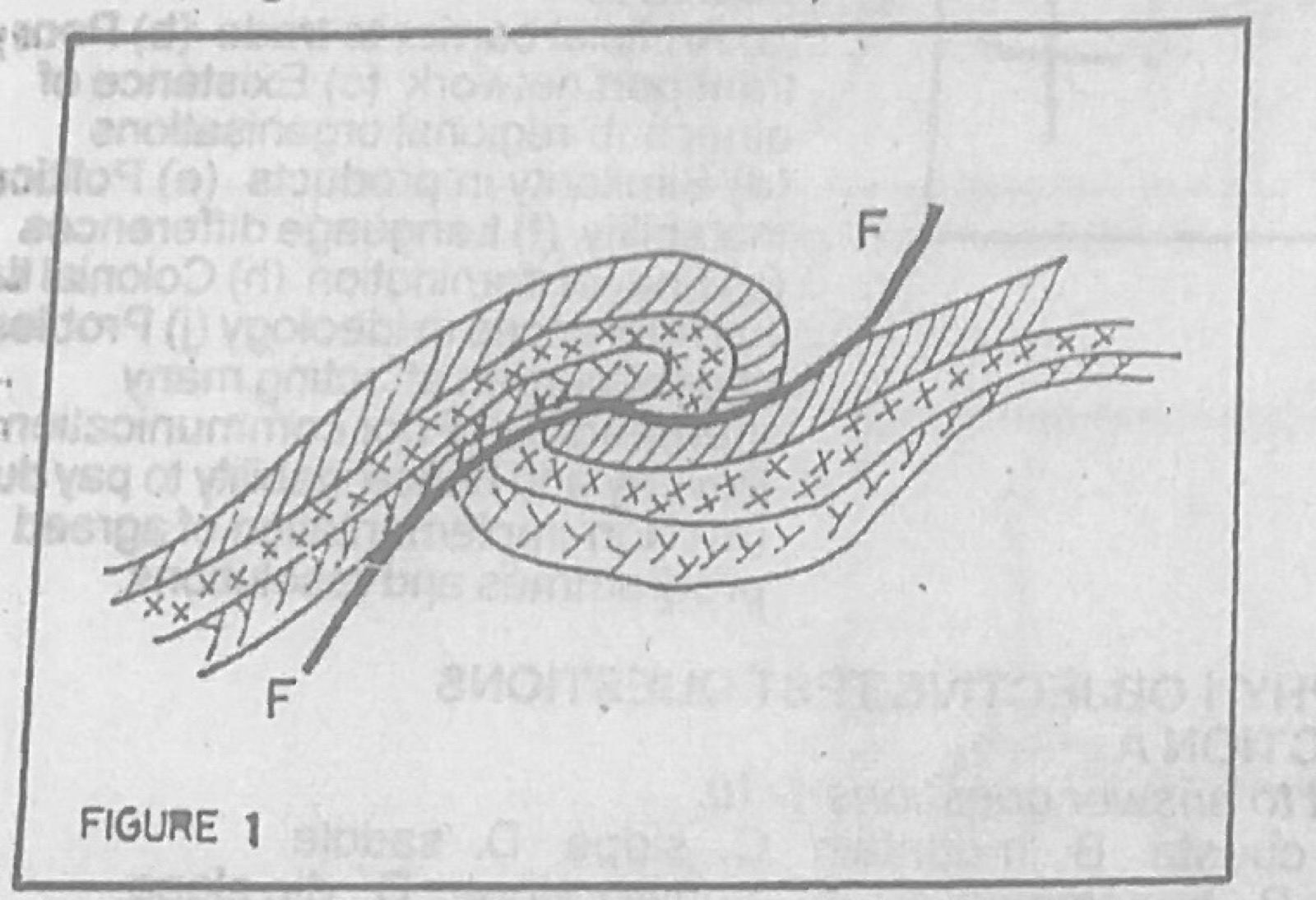
Use Figure 1 (a cross-section of folded rock layers with a line marked F–F) to answer this question. The Figure 1 represents

Diagram for this question
  1. A.an overthrust fold
  2. B.a simple fold
  3. C.an asymmetrical fold
  4. D.a symmetrical fold.
Show the answer and explanation

Answer: A (an overthrust fold)

Explanation

The fold has been pushed over so far that it has broken and moved along a thrust plane (F–F): an overthrust fold.

Open this question

Question 24

Earth Movements and Vulcanicity

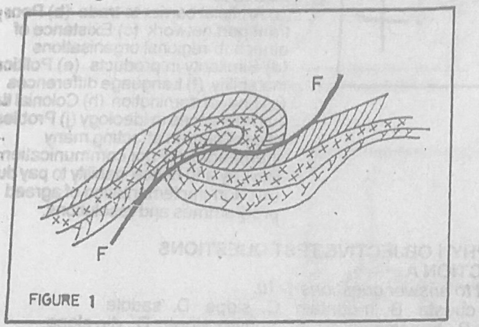
Use Figure 1 (a cross-section of folded rock layers with a line marked F–F) to answer this question. The line FF is called

Diagram for this question
  1. A.an isoline
  2. B.a line of fracture
  3. C.a syncline
  4. D.an anticline.
Show the answer and explanation

Answer: B (a line of fracture)

Explanation

F–F is the fault (fracture) plane along which the fold has been thrust.

Open this question

Question 25

Rivers and River Landforms

Which of the following is a feature of river deposition?

  1. A.Levée
  2. B.Scree
  3. C.Barchan
  4. D.Morraine.
Show the answer and explanation

Answer: A (Levée)

Explanation

Levées are raised banks built by floods depositing silt beside the river.

Open this question

Question 26

Coastal Landforms

The swash of a wave is more powerful than the backwash because it

  1. A.carries more sand
  2. B.has the force of the breaking wave behind it
  3. C.brings more water
  4. D.has a long length.
Show the answer and explanation

Answer: B (has the force of the breaking wave behind it)

Explanation

The swash is driven up the beach by the energy of the breaking wave, while the backwash only drains back by gravity.

Open this question

Question 28

Weather

A fog is most likely to develop when a

  1. A.cold dry wind blows over a cold current
  2. B.warm moist wind blows over a cold current
  3. C.cold dry wind blows over a warm current
  4. D.warm moist wind blows over a warm current.
Show the answer and explanation

Answer: B (warm moist wind blows over a cold current)

Explanation

Warm moist air is chilled to dew point over cold water, so its vapour condenses as fog.

Open this question

Question 29

Weather

The instrument used for measuring atmospheric pressure is

  1. A.wind vane
  2. B.anemometer
  3. C.barometer
  4. D.wet bulb thermometer.
Show the answer and explanation

Answer: C (barometer)

Explanation

A barometer measures air pressure.

Open this question

Question 30

Weather

Humidity is the amount of

  1. A.cloud cover in the sky
  2. B.water vapour in the atmosphere
  3. C.moisture needed to cause condensation
  4. D.mist in the atmosphere.
Show the answer and explanation

Answer: B (water vapour in the atmosphere)

Explanation

Humidity is the water vapour content of the air.

Open this question

Question 31

Weather

Convectional rains are most common in

  1. A.Equatorial regions and Tropical Monsoon climates
  2. B.Polar regions and Mediterranean climates
  3. C.Temperate regions
  4. D.Temperate and Mediterranean regions.
Show the answer and explanation

Answer: A (Equatorial regions and Tropical Monsoon climates)

Explanation

Strong heating of moist air in hot wet regions produces convectional rain.

Open this question

Question 32

Weather

The instrument used for measuring relative humidity is called

  1. A.hygrometer
  2. B.wind vane
  3. C.anemometer
  4. D.thermometer.
Show the answer and explanation

Answer: A (hygrometer)

Explanation

A hygrometer (wet- and dry-bulb thermometers) measures relative humidity.

Open this question

Question 33

Weather

Equal degree of cloudiness is represented by

  1. A.isoneph
  2. B.isobar
  3. C.choropleth map
  4. D.pie chart.
Show the answer and explanation

Answer: A (isoneph)

Explanation

Isonephs join places with equal cloud cover.

Open this question

Question 34

Population

Which of the following is not a problem of overpopulation?

  1. A.Widespread unemployment
  2. B.Inadequate workforce
  3. C.A rapid increase in population
  4. D.A decline in standard of health
Show the answer and explanation

Answer: B (Inadequate workforce)

Explanation

Overpopulation gives too many workers, not too few; an inadequate workforce is a problem of underpopulation.

Open this question

Question 35

Geography of Africa

The largest man-made lake in Africa is

  1. A.Volta
  2. B.Tana
  3. C.Malawi
  4. D.Kainji.
Show the answer and explanation

Answer: A (Volta)

Explanation

Lake Volta behind the Akosombo dam is the largest man-made lake by area; Tana and Malawi are natural.

Open this question

Question 36

Mining and Energy

Africa's exploitation of solar energy will result in the following except

  1. A.less amount of solar energy received by plants for photosynthesis
  2. B.savings in liquid fuel
  3. C.savings on electricity cost
  4. D.reduction in the use of fuel wood.
Show the answer and explanation

Answer: A (less amount of solar energy received by plants for photosynthesis)

Explanation

Using some sunlight for power does not reduce the sunlight reaching plants.

Open this question

Question 37

Geography of Africa

Which of the following mountains is not in Africa?

  1. A.Tibesti
  2. B.Atlas
  3. C.Andes
  4. D.Ruwenzori.
Show the answer and explanation

Answer: C (Andes)

Explanation

The Andes are in South America.

Open this question

Question 38

Climate

All the following are associated with rainfall in Africa except

  1. A.movement of the ITCZ
  2. B.convectional nature of hot tropical air
  3. C.movement of moist air masses over higher ground
  4. D.on-shore movement of cold air.
Show the answer and explanation

Answer: D (on-shore movement of cold air.)

Explanation

Cold air moving onshore (e.g. over the Benguela current) is dry and stable and brings little rain.

Open this question

Question 39

Geography of Africa

Which of the following is a landlocked country?

  1. A.Chana
  2. B.Tunisia
  3. C.Burundi
  4. D.South Africa
Show the answer and explanation

Answer: C (Burundi)

Explanation

Burundi has no coastline; the others border the sea.

Open this question

Question 40

Geography of Africa

Which of the following countries is a major producer of copper?

  1. A.Chad
  2. B.Zambia
  3. C.Burundi
  4. D.Morocco.
Show the answer and explanation

Answer: B (Zambia)

Explanation

Zambia's Copperbelt is one of the world's major copper areas.

Open this question

Question 41

Soils

The dominant climatic elements that control soil development are

  1. A.temperature and pressure
  2. B.precipitation and wind
  3. C.temperature and precipitation
  4. D.precipitation and humidity.
Show the answer and explanation

Answer: C (temperature and precipitation)

Explanation

Temperature and rainfall control weathering, leaching and the decay of organic matter.

Open this question

Question 42

The Ecosystem

Figure 2 shows a feeding relationship in an ecosystem: Grass — Grasshopper — Lizard — Snake — Hawk. The feeding relationship above shows a

  1. A.symbiotic relationship
  2. B.parasitic relationship
  3. C.food chain
  4. D.food web.
Show the answer and explanation

Answer: C (food chain)

Explanation

A single line of who-eats-whom from grass to hawk is a food chain.

Open this question

Question 43

The Ecosystem

Figure 2 shows a feeding relationship in an ecosystem: Grass — Grasshopper — Lizard — Snake — Hawk. Which of the following is a primary producer?

  1. A.Snake
  2. B.Lizard
  3. C.Grass
  4. D.Grasshopper
Show the answer and explanation

Answer: C (Grass)

Explanation

Green plants such as grass make food by photosynthesis, so they are the producers.

Open this question

Question 44

The Ecosystem

The relationship between the elements of an ecosystem is best described as

  1. A.parasitic
  2. B.symbiotic
  3. C.multidirectional
  4. D.interdependent.
Show the answer and explanation

Answer: D (interdependent.)

Explanation

All living and non-living parts of an ecosystem depend on one another.

Open this question

Question 45

Oceans and Lakes

Which of the following is not a characteristic of warm currents?

  1. A.They flow mostly along the east coast of continents
  2. B.They flow from the polar region to the equatorial region
  3. C.They have a high surface temperature
  4. D.They flow from the equatorial to the polar region.
Show the answer and explanation

Answer: B (They flow from the polar region to the equatorial region)

Explanation

Warm currents flow from the equator towards the poles; currents from polar regions are cold.

Open this question

Question 47

Vegetation

TheSahel savanna vegetation is predominantly found in

  1. A.Côte d'Ivoire
  2. B.Mauritania
  3. C.Morocco
  4. D.Serra Leone.
Show the answer and explanation

Answer: B (Mauritania)

Explanation

The Sahel lies along the southern edge of the Sahara, covering much of Mauritania.

Open this question

Question 48

Geography of Africa

Which of the following is not a problem of timber exploitation in Tropical Africa?

  1. A.Inadequate transport facilities
  2. B.Trees not in pure stand
  3. C.Difficult terrain
  4. D.Heavy rainfall.
Show the answer and explanation

Answer: D (Heavy rainfall.)

Explanation

Heavy rainfall helps the forest grow; the other options make logging difficult.

Open this question

Question 49

Geography of Africa

The largest off-shore island in Africa is the

  1. A.Island of Madagascar
  2. B.Canary Island
  3. C.St. Helena Island
  4. D.Cape Verde Island.
Show the answer and explanation

Answer: A (Island of Madagascar)

Explanation

Madagascar is by far the largest island off Africa.

Open this question

Question 50

West Africa and ECOWAS

Which of the following is not a capital city of an ECOWAS state?

  1. A.Nairobi
  2. B.Lome
  3. C.Dakar
  4. D.Bissau.
Show the answer and explanation

Answer: A (Nairobi)

Explanation

Nairobi is the capital of Kenya in East Africa.

Open this question

Theory question 101

Transport, Trade and Tourism

(a) Explain four ways in which water transport is important in international trade (b) Outline four limitations of water transportation (c) Suggest solutions to any two of the problems outlined in 1(b) above

Show the model answer
Model answer

(a) Links continents and countries for trade; cheapest way to carry bulky goods (oil, ores, grain) over long distances; carries very large volumes; natural routes need little construction; carries a wide variety of goods including refrigerated cargo; relatively safe.
(b) Slow; not flexible (no door-to-door service); only countries with coasts or navigable rivers can use it; affected by storms, fog and ice; seasonal rivers, rapids and waterfalls; silting of ports; high cost of ships and ports; water weeds.
(c) Build faster and refrigerated ships; dredge ports and channels; canals and locks around rapids; ice-breakers; clear weeds; use navigational aids and weather forecasting; transit agreements for landlocked countries.

Explanation

Match each solution to a limitation.

Open this question

Theory question 102

Population

(a) Explain four factors which are responsible for the sparse population of the West Coast of South Africa. (b) Highlight three disadvantages of the low population density of the West Coast of South Africa. (c) Suggest three ways by which the population in the West Coast of South Africa can be increased.

Show the model answer
Model answer

(a) Desert climate (Namib, Kalahari edge) with very low rainfall caused by the cold Benguela current; few rivers for water and irrigation; poor sandy soils discourage farming; high temperatures and harsh conditions; lies in the rain shadow of the interior highlands; poor transport and few industries; limited jobs.
(b) Shortage of labour; resources left unused; small market for goods; low government revenue; high cost of providing services to few people; slow development.
(c) Irrigation schemes for farming; develop mining and fishing industries; build roads and new towns; provide social amenities; create jobs and incentives for settlers; desalination for water supply.

Explanation

Explain how the cold current makes the coast dry.

Open this question

Theory question 103

Manufacturing Industry

(a) Describe four factors that favour the location of brewery industry. (b) Outline three contributions of manufacturing industries to the economic development of Tropical Africa. (c) Highlight three problems facing manufacturing industries in Tropical Africa.

Show the model answer
Model answer

(a) Large market nearby (beer is bulky and breakable, so breweries are close to consumers in towns); raw materials (barley/sorghum/maize, hops) and plentiful clean water; regular power supply; capital; good transport; skilled labour and technical know-how; government policy.
(b) Employment; foreign exchange savings and earnings; government revenue; diversification of the economy; development of infrastructure; transfer of technology; provision of goods; growth of towns.
(c) Shortage of capital; erratic power supply; poor transport; shortage of skilled labour; low purchasing power; competition from imports; political instability; shortage of raw materials and spare parts.

Explanation

For breweries, stress market and water supply.

Open this question

Theory question 104

Nigeria: People and Economy

For candidates in Nigeria: (a) Draw an outline map of Nigeria. On the map, locate and name: (i) one area of cocoa production (ii) one area of cotton production (iii) one area of rubber production (iv) one town in each of the areas in 4(a)(i) – (iii) above. (b) Highlight three physical conditions necessary for the production of any of the named crops in 4(a)(i) – (iii) above (c) Outline any two ways in which cash crops are important to the economy of Nigeria.

Show the model answer
Model answer

(a) Cocoa: south-west (Ondo, Oyo, Osun, Ogun), town Akure, Ibadan, Ondo; cotton: north (Zaria, Funtua, Gusau, Katsina); rubber: Edo, Delta, Cross River (Benin City, Sapele, Calabar).
(b) Cocoa: high temperatures (21-32°C); rainfall 1,250-2,000 mm well distributed; deep well-drained fertile loamy soils; shade from taller trees; shelter from strong winds; gentle slopes. Cotton: warm temperatures; moderate rainfall (500-1,250 mm) with a dry period for ripening and picking; well-drained loamy soils; plenty of sunshine. Rubber: hot humid climate; heavy rainfall (over 2,000 mm); deep well-drained soils; lowland.
(c) Foreign exchange from exports; raw materials for local industries (textiles, tyres, chocolate); employment and income for farmers; government revenue; growth of towns and transport.

Explanation

Give the three conditions for one crop only.

Open this question

Theory question 105

Nigeria: Physical Setting

For candidates in Nigeria: (a) Draw an outline map of Nigeria. On the map, show and name: (i) three vegetation belts; (ii) one important town in each belt. (b) Highlight three effects of rainfall on vegetation in Nigeria. (c) State two uses of vegetation resources in Nigeria

Show the model answer
Model answer

(a) Mangrove swamp forest (Port Harcourt, Warri); tropical rain forest (Benin City, Ibadan, Enugu); Guinea savanna (Ilorin, Makurdi, Abuja); Sudan savanna (Kano, Sokoto, Kaduna); Sahel savanna (Maiduguri, Nguru); montane vegetation (Jos, Obudu).
(b) Heavy rainfall in the south gives evergreen forest with tall trees; rainfall decreases northward so vegetation changes to savanna and grasses get shorter; low rainfall in the far north gives short grass and thorny shrubs (Sahel); seasonal rainfall makes savanna trees deciduous; length of the rainy season decides how dense the vegetation is.
(c) Timber and fuelwood; pasture for livestock; food, fruits and medicinal herbs; raw materials for industries; protect soils; tourism and wildlife habitat.

Explanation

Draw the belts from the coast northward in the correct order.

Open this question

Theory question 106

Nigeria: Physical Setting

For candidates in Nigeria: (a) Draw a sketch map of Nigeria. On the map, locate and name (i) one highland area in the North East; (ii) one highland area in the West; (iii) two rivers that take their sources from these highland areas; (iv) one man-made lake; (v) the lake Chad (b) Explain four ways in which highlands of Nigeria are important.

Show the model answer
Model answer

(a) North-east highland: Mandara Mountains, Biu Plateau, Adamawa highlands; western highland: Western (Yoruba) uplands around Oyo, Ekiti, Ondo; rivers: Gongola, Hawal (from the north-east), Ogun, Osun, Owena (from the west); man-made lake: Kainji, Jebba, Shiroro, Tiga, Bakolori; Lake Chad in the north-east corner.
(b) Sources of rivers used for water and HEP; cool climate good for settlement, tourism and livestock (Jos, Obudu, Mambilla); rich in minerals (tin, columbite on the Jos Plateau); farming of temperate crops (Irish potatoes, tea); influence climate by causing relief rain; forests and wildlife; historical defence sites.

Explanation

Mark the rivers starting in the named highlands.

Open this question

Theory question 107

Agriculture, Fishing and Lumbering

(a) Explain three conditions that favour fruit farming in the Mediterranean Regions of Africa. (b) Outline four problems facing fruit farming in the Mediterranean Regions of Africa. (c) Highlight three ways in which fruit farming is of economic importance to the Mediterranean Regions.

Show the model answer
Model answer

(a) Hot sunny dry summers ripen and sweeten fruits; mild wet winters supply moisture; fertile soils in valleys and coastal plains; irrigation water from rivers and wells; nearness to European markets and good ports; skilled labour and research; cheap labour.
(b) Summer drought requiring costly irrigation; pests and diseases; hilly terrain and soil erosion; shortage of capital; poor storage and processing facilities; competition in world markets and price changes; frost in some winters.
(c) Foreign exchange from exports (citrus, grapes, olives, dates); employment; raw materials for canning, wine and olive oil industries; income for farmers; government revenue; food supply.

Explanation

Link each condition to the Mediterranean climate.

Open this question

Theory question 108

Geography of Africa

(a) Draw a sketch map of the Nile Valley. On the map, show and name (i) two farming areas; (ii) two products from each area in 8(a)(i) above. (b) In what five ways in the River Nile of economic importance to Egypt and the Sudan?

Show the model answer
Model answer

(a) Nile from Lake Victoria through Sudan and Egypt to the delta; farming areas: Nile delta (cotton, rice, wheat, maize) and Nile valley of Egypt (sugarcane, wheat, cotton); Gezira plain between the White and Blue Nile in Sudan (cotton, groundnuts, wheat, sorghum).
(b) Water for irrigation of cotton and food crops; fertile alluvial soils from floods; hydro-electric power (Aswan High Dam, Sennar, Roseires); transport of people and goods; fishing (Lake Nasser); domestic and industrial water supply; tourism (cruises, monuments); flood control.

Explanation

Name the dams that give power and irrigation water.

Open this question

Theory question 109

Geography of Africa

(a) Draw a sketch map of Africa. On the map, locate and name (i) Rivers Niger and Zambezi; (ii) Lake Victoria; (iii) Latitudes 23½°N and 23½°S; (iv) The Atlas Mountains (v) Two mining areas — one for petroleum in West Africa and one for gold in South Africa. (b) Highlight five ways in which either petroleum or gold is of economic importance to the area in 9(a)(v) above.

Show the model answer
Model answer

(a) Niger from Guinea through Mali, Niger and Nigeria to the Gulf of Guinea; Zambezi from Zambia/Angola east to the Indian Ocean in Mozambique; Lake Victoria in East Africa astride the equator; Tropics of Cancer and Capricorn; Atlas Mountains in north-west Africa (Morocco, Algeria); petroleum: Niger Delta (Nigeria); gold: Witwatersrand (Johannesburg).
(b) Petroleum (Niger Delta) or gold (Witwatersrand): foreign exchange; government revenue; employment; raw materials for industries (petrochemicals, jewellery); growth of towns (Port Harcourt, Johannesburg); infrastructure (roads, railways); attracts foreign investment; manpower development.

Explanation

Choose either petroleum or gold for (b) and stay with it.

Open this question

Theory question 202

Statistical Maps and Diagrams

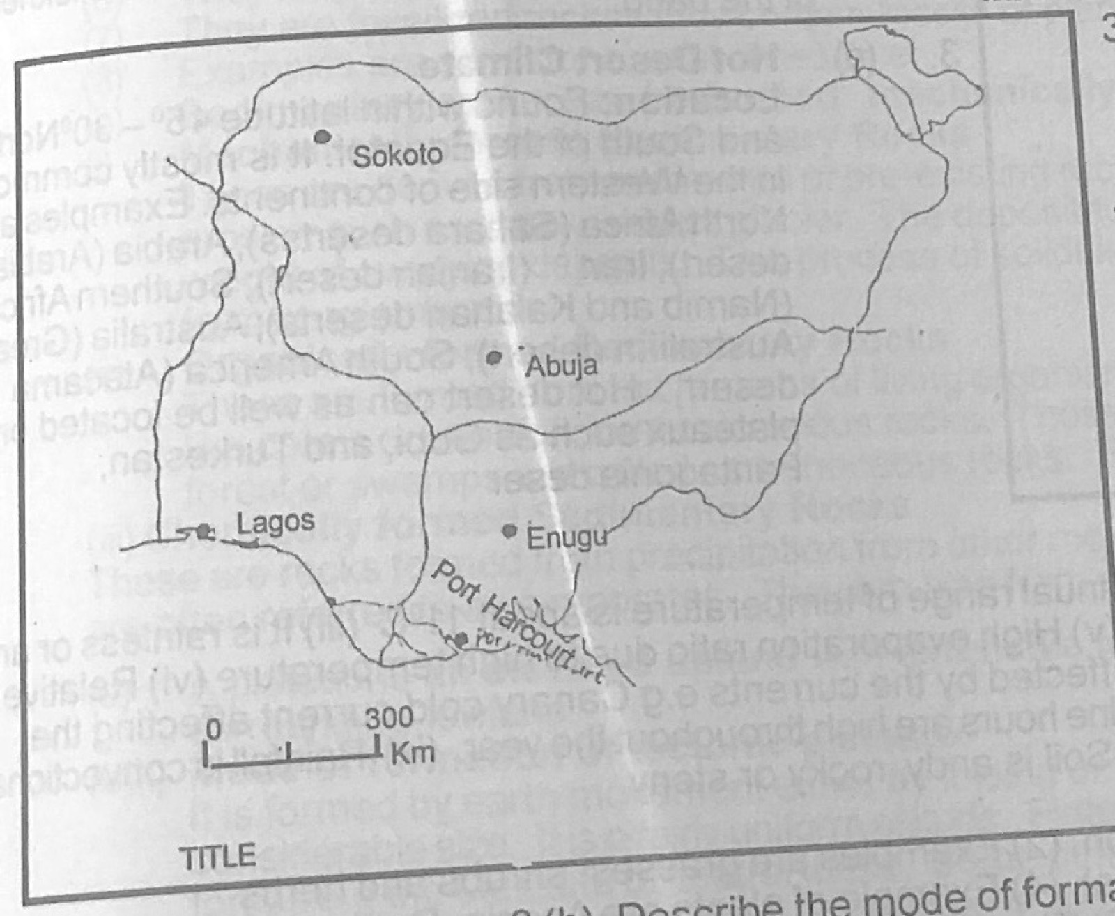
The Table 1 below shows the volume of air passenger traffic between Lagos and four other cities in Nigeria in 1985. Study the table and use the data in it to answer the questions that follow:
Table 1 – Volume of air passenger traffic between Lagos and four other cities in Nigeria, 1985
1. Lagos – Abuja: 500,000
2. Lagos – Enugu: 200,000
3. Lagos – Port Harcourt: 400,000
4. Lagos – Sokoto: 300,000
(a) Using the attached map of Nigeria — Map B, construct a flow map/chart to represent the data in Table 1. (b) State two advantages of representing data with flow maps.

Diagram for this question
Show the model answer
Model answer

(a) Choose a scale for band width, e.g. 1 mm = 50,000 passengers (or 1 cm = 200,000): Abuja 10 mm (2.5 cm), Port Harcourt 8 mm (2.0 cm), Sokoto 6 mm (1.5 cm), Enugu 4 mm (1.0 cm); draw a band from Lagos to each city along the route, its width proportional to the passengers; add title, key/width scale, north arrow.
(b) Shows both the direction (route) and volume of movement at a glance; makes comparison of routes easy; gives a clear visual impression; shows the location of places linked.

Explanation

Make band width proportional to the number of passengers and give the width scale.

Open this question

Theory question 203

Climate

Write a geographical account of Hot Desert Climate under the following: (a) Location (b) Characteristic features, (c) Vegetation, (d) Human activities.

Show the model answer
Model answer

(a) Between about 15° and 30° N and S, on the western sides of continents: Sahara, Kalahari and Namib (Africa), Arabian, Thar, Atacama, Mojave/Arizona, Great Australian Desert.
(b) Very high day temperatures (over 38°C) and cold nights, large diurnal range (up to 20°C); rainfall very low (under 250 mm) and unreliable; very low humidity and high evaporation; clear skies and intense sunshine; dry trade winds and dust storms; occasional flash floods.
(c) Scanty xerophytic plants: cacti, thorny bushes, acacia, date palms at oases; plants with long roots, thick waxy or spiny leaves, water-storing stems; short-lived plants that bloom after rain; large areas bare.
(d) Nomadic herding of camels, goats and sheep; oasis farming (dates, millet, vegetables) with irrigation; mining (oil, gas, phosphate, salt, diamonds); trading by caravans; tourism.

Explanation

Write notes under each of the four headings.

Open this question

Theory question 204

Environmental Resources

(a)(i) Define the term Environmental Resources. (ii) List two types of Environmental Resources other than water. (b) Highlight four ways in which water is important as an environmental resource. (c) Outline two problems that might arise from the degradation of water resources.

Show the model answer
Model answer

(a)(i) Environmental resources are the useful materials and conditions in the natural environment that man uses to satisfy his needs.
(ii) Land/soil resources; mineral resources; vegetation (forest) resources; atmospheric resources (wind, sunshine); wildlife; human resources.
(b) Drinking and domestic use; irrigation and agriculture; hydro-electric power; transport; fishing; industrial use (cooling, processing); recreation and tourism; habitat for aquatic life.
(c) Shortage of safe drinking water; spread of water-borne diseases; death of fish and aquatic life; reduced farm output; loss of income for fishermen; conflicts over water.

Explanation

Give a use and an example for each point.

Open this question

Theory question 205

Oceans and Lakes

(a) Draw a diagram to show the relief features of an ocean floor. (b) Highlight three main characteristics of the continental shelf. (c) In what three ways is the continental shelf of importance to man?

Show the model answer
Model answer

(a) Cross-section from the coast: continental shelf (gentle slope to about 180-200 m), continental slope (steep), continental rise, deep-sea (abyssal) plain with oceanic ridges, seamounts/volcanic islands and ocean deeps/trenches; label each.
(b) Gently sloping margin of the continent; shallow water, usually less than 200 m deep; width varies from a few km to hundreds of km; covered with sediments from the land; sunlight reaches the bottom.
(c) Rich fishing grounds (plankton growth); source of petroleum, gas and other minerals; good for harbours and ports; recreation and tourism; sand and gravel for construction.

Explanation

Label shelf, slope, plain, ridge and trench on the diagram.

Open this question

Theory question 206

Rocks

(a) Outline the characteristics of sedimentary rocks. (b) Describe two ways in which sedimentary rocks can be formed

Show the model answer
Model answer

(a) Laid down in layers (strata) separated by bedding planes; usually contain fossils; non-crystalline; often porous and permeable; relatively soft and easily eroded; may be folded or tilted; formed mostly under water; varied particle sizes.
(b) Mechanically formed: particles from weathered rock are carried by rivers, wind, ice or waves, deposited in layers and compressed and cemented (sandstone, shale, clay, conglomerate). Organically formed: remains of plants (coal) or of shells and skeletons of animals (limestone, chalk, coral) pile up and are compressed. Chemically formed: minerals precipitate from solution when water evaporates (rock salt, gypsum, potash).

Explanation

For each mode give the process and examples.

Open this question

Theory question 207

Earth Movements and Vulcanicity

(a) What is a plateau? (b) Describe the mode of formation of: (i) Tectonic plateaux (ii) Dissected plateaux. (c) Outline three ways in which plateaux are important to man.

Show the model answer
Model answer

(a) A plateau is an extensive area of upland with a fairly flat or gently undulating top and at least one steep side, rising well above the surrounding land.
(b)(i) Tectonic plateaux: formed by earth movements; land is uplifted by compressional or vertical forces, or is enclosed by fold mountains (intermont plateaux such as Tibet), or rises between faults; e.g. East African plateau, Deccan (uplift), Tibet.
(ii) Dissected plateaux: an old plateau is cut up by rivers and glaciers through vertical erosion and weathering; deep valleys separate flat-topped remnants, giving a rugged surface, e.g. Jos Plateau edges, Scottish Highlands.
(c) Rich in minerals (tin on Jos Plateau, gold in South Africa); cool climate good for settlement, tourism and livestock (Jos, Mambilla); good grazing lands; sites for HEP from rivers falling off the edges; sources of rivers; farming of temperate crops.

Explanation

Distinguish uplift (tectonic) from erosion (dissected).

Open this question

Theory question 208

Vegetation

(a) Highlight four differences between the Tropical Grassland and the Temperate Grassland. (b) Describe the climate associated with one of the vegetation belts in 8(a) above.

Show the model answer
Model answer

(a) Tropical grassland lies between about 5° and 20° N and S; temperate grassland in the interior of continents at about 30°-55°. Tropical grasses are tall (1-3 m) and coarse; temperate grasses are short, soft and nutritious. Tropical grassland has scattered trees (baobab, acacia, shea); temperate grassland is almost treeless (trees mainly along rivers, e.g. willows, poplars). Tropical grass grows in the wet season and dries in the dry season; temperate grass grows in spring and summer and dies back in the cold winter. Local names: savanna, llanos, campos (tropical); prairies, steppes, pampas, veld, downs (temperate).
(b) Tropical grassland (savanna): hot all year (about 21-32°C), annual range 5-11°C; distinct wet season (summer) and long dry season; rainfall 500-1,500 mm, convectional, single maximum; high humidity in the wet season, low in the dry season with harmattan dust. OR Temperate grassland: continental, hot summers (about 20-25°C) and very cold winters (below freezing), large annual range; low rainfall (250-750 mm) mainly in early summer; dry winters with snow.

Explanation

Compare the two by location, grass, trees and seasons.
Open this question