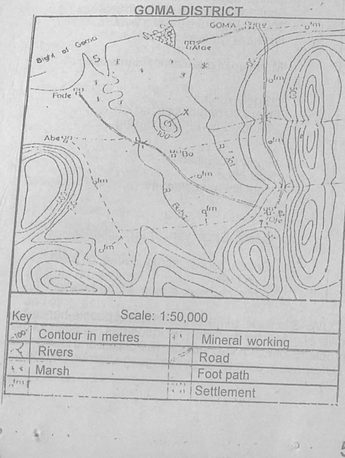
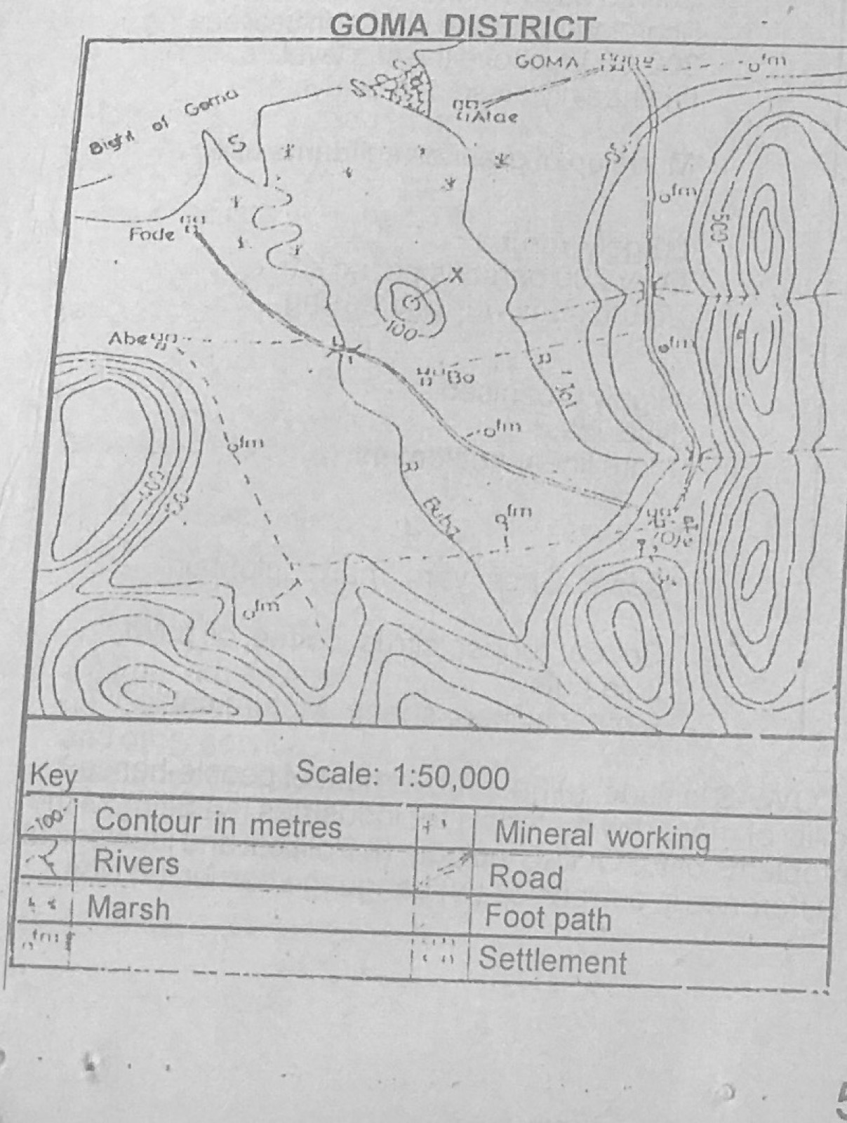
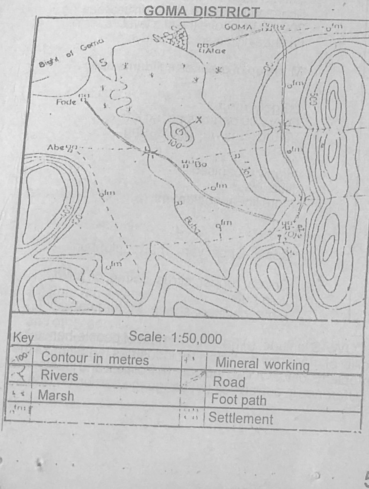
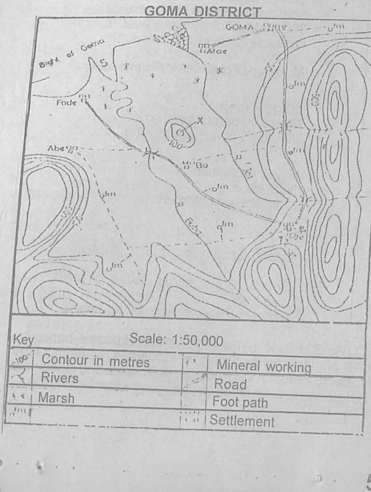
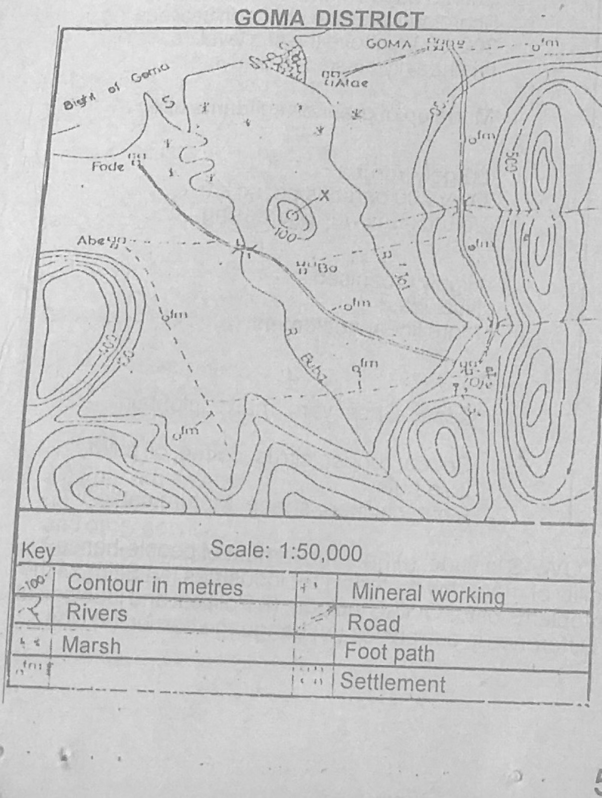
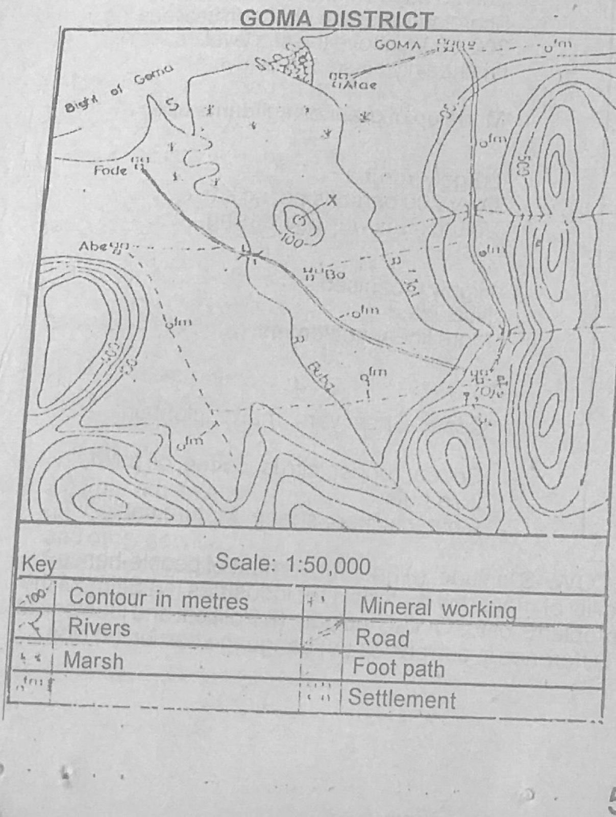
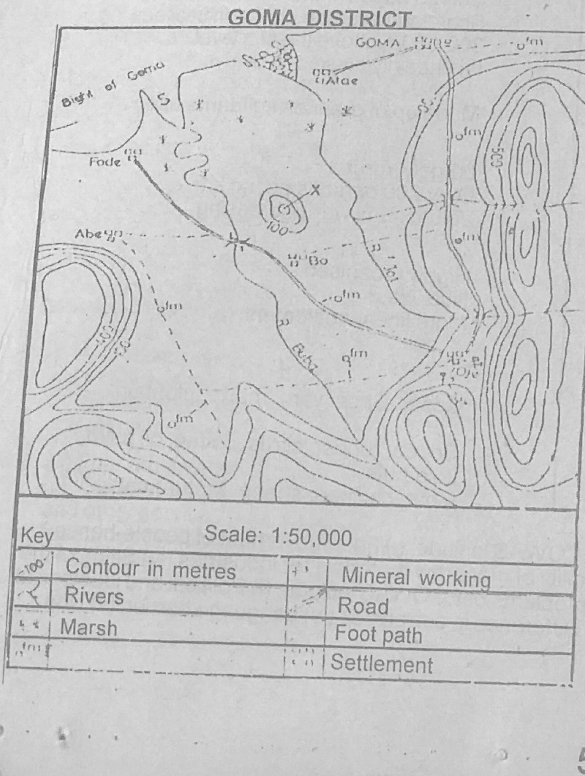
Use the map of GOMA DISTRICT to answer this question. Which of the following factors best explains the presence of marsh in the north-western part of the area?
A.Heavy rainfall
B.River erosion
C.Poor drainage
D.Rise in sea level
E.Presence of impervious rocks
Show the answer and explanation
Answer: C (Poor drainage)
Explanation
The north-west is flat, low land beside the coast where water cannot drain away quickly, so marsh forms.
They are tropical and subtropical storms, occuring over land, they are funnel-shaped and violent, with winds of high velocity reaching up to 330kmph. Which of the following winds is described above?
A.Chinook
B.Hurricane
C.Typhoon
D.Fohn
E.Tornado
Show the answer and explanation
Answer: E (Tornado)
Explanation
A tornado is a small, violent, funnel-shaped storm over land; hurricanes and typhoons form over oceans.
(a) Explain the following terms: (i) Over-population; (ii) Migration (b) Describe any three factors which encourage the occurrence of each term in (a) above within a population group
Show the model answer
Model answer
(a)(i) Over-population: more people in an area than its resources and technology can support at a reasonable standard of living. (ii) Migration: movement of people from one place to another to live, temporarily or permanently. (b) Over-population: high birth rate with falling death rate; early marriage and desire for large families (culture, religion); low use of family planning; immigration; limited resources or low technology. Migration: search for jobs and better pay (push from poverty, pull of towns); natural disasters such as drought and floods; war and insecurity; education and social amenities; marriage; land shortage.
Explanation
Define each term, then give three causes for each.
(a) Using specific examples, identify any three classes of settlements based on their functions (b) Describe the characteristics of any two of the settlement types identified in (a) above.
Show the model answer
Model answer
(a) e.g. Administrative (Abuja, Washington DC); commercial (Lagos, Onitsha, Kano); industrial (Aba, Port Harcourt, Pittsburgh); mining (Jos, Enugu, Johannesburg); educational (Nsukka, Oxford); religious (Mecca, Rome); port (Lagos, Mombasa). (b) e.g. Administrative: seat of government offices; many civil servants; planned layout with government buildings; good amenities. Commercial: large markets, shops and banks; many traders; very accessible, a focus of routes; dense population. Mining: grows near mineral deposits; miners and related workers; may decline when minerals are exhausted.
(a) Give three reasons why air transportation may be preferred to the other modes of transportation (b) State any three disadvantages of air transportation (c) How can these disadvantages be overcome?
Show the model answer
Model answer
(a) Fastest mode over long distances; not blocked by relief, rivers or seas; best for perishable and high-value goods and mail; comfortable and convenient for passengers; links remote areas. (b) Very expensive fares and freight; cannot carry very bulky/heavy goods cheaply; affected by bad weather; accidents are usually fatal; airports are costly and need much land; noise pollution; hijacking. (c) Subsidies and competition to reduce fares; bigger cargo planes; modern navigation and weather equipment; training of crew and maintenance; tighter security.
(a) Give an example of a (i) light industry? (ii) heavy industry? (b) Describe any four characteristics of each type of industry (c) Explain any three favourable factors for the location of any one of the industries
Show the model answer
Model answer
(a)(i) e.g. textiles, matches, printing, food processing, furniture. (ii) e.g. iron and steel, shipbuilding, petroleum refining, cement. (b) Light: small raw materials and products; little capital; small machines; can be sited almost anywhere, often near markets; many workers including women; consumer goods. Heavy: bulky raw materials and products; large capital; heavy machinery; large sites near raw materials, water or ports; skilled labour; often produce goods for other industries. (c) e.g. for iron and steel at Ajaokuta: raw materials (iron ore at Itakpe); water and transport on the Niger; power; government policy; market.
(a) What five advantages could be derived when countries trade with one another? (b) Highlight four factors which influenced the trade between Nigeria and Canada.
Show the model answer
Model answer
(a) Countries get goods they cannot produce; specialisation in what each produces best; foreign exchange earnings; larger markets so industries expand; jobs; exchange of technology and ideas; better international relations. (b) Differences in natural resources and climate (Nigeria: oil, cocoa; Canada: wheat, machinery); different levels of industrial development; Commonwealth membership and common language; trade agreements and tariffs; transport/shipping links; demand and taste; foreign exchange availability.
Explanation
Trade happens because countries differ in what they produce.
(a) On a sketch map of Nigeria, show and name the (i) three climatic belts; (ii) dominant air masses which influence the climate of Nigeria (b) Outline three ways in which the Sudan savannah vegetation has adapted itself to the climate in Nigeria (c) In what four ways is natural vegetation of economic importance to man in Nigeria?
Show the model answer
Model answer
(a) Map with sub-equatorial/humid tropical belt in the south, tropical hinterland (savanna) belt in the middle, tropical continental belt in the north; arrows for the tropical maritime air mass from the south-west (Atlantic) and tropical continental air mass from the north-east (Sahara). (b) Trees shed leaves in the dry season; long tap roots reach deep water; thick bark resists fire and drought; small, thorny or waxy leaves reduce water loss; grasses dry up and grow again with the rains; some trees store water in their trunks. (c) Timber and fuelwood; food (fruits, nuts, game); pasture for livestock; raw materials (shea butter, gum arabic, fibres); medicines; protects soil; tourism and wildlife; jobs.
(a) Explain any four problems facing Agriculture in Nigeria (b) Highlight three effects of these problems on the economic development of Nigeria (c) How can the problems in (a) above be solved?
Show the model answer
Model answer
(a) Use of simple tools; land tenure and fragmentation; shortage of labour as youths move to towns; lack of capital and credit; pests and diseases; poor soils and erosion; poor storage, transport and marketing; unreliable rainfall. (b) Low food production and high food prices; food imports and loss of foreign exchange; low raw materials for industries; low farm incomes and rural poverty; unemployment. (c) Mechanisation; land reform; credit and loans to farmers; improved seeds, fertilisers and pest control; irrigation; rural roads, storage and markets; extension services and research.
(a) On an outline map of Nigeria, locate and name: (i) the rail lines linking Lagos to Nguru (ii) the railway line linking Port-Harcourt to Kaduna (b) Explain any four ways in which rail contributed to the economic development of Nigeria (c) Highlight any three problems of rail transportation in Nigeria
Show the model answer
Model answer
(a) Western line: Lagos-Ibadan-Ilorin-Jebba-Minna-Kaduna-Zaria-Kano-Nguru. Eastern line: Port Harcourt-Aba-Enugu-Makurdi-Kafanchan-Kaduna. (b) Carries bulky export crops (groundnuts, cotton, cocoa) to the ports; carries minerals (coal, tin) and fuel; distributes imports and manufactured goods inland; growth of towns along the lines (Kaduna, Kafanchan); employment; movement of people; national unity. (c) Old track and engines; single narrow-gauge lines; slow speed and delays; poor maintenance and management; competition from road transport; inadequate funding; vandalism.
Write a geographical account of the Chad basin under the following headings: (a) Relief and drainage (b) Agriculture (c) Problems of development
Show the model answer
Model answer
(a) Low, flat plain about 300 m above sea level sloping gently towards Lake Chad; inland drainage; rivers Yobe (Komadugu-Yobe), Hadejia and Ngadda flow into the lake; seasonal rivers; fadama (flood plains) and marshes near the lake. (b) Crops: millet, guinea corn, groundnuts, wheat, cotton, rice; irrigation schemes (South Chad Irrigation Project, Kano river/Hadejia valley); cattle, sheep and goats by Fulani and Shuwa Arabs; fishing on Lake Chad. (c) Low, unreliable rainfall and drought; desert encroachment; shrinking of Lake Chad; poor sandy soils; remoteness and poor transport; pests (locusts, quelea birds); insecurity; shortage of capital.
Compare and contrast the Eastern Scarplands and Western Highlands under the following headings: (a) Relief (b) Peoples and population (c) Settlement patterns (d) Agriculture
Show the model answer
Model answer
(a) Eastern Scarplands: cuesta (escarpment) landscape of sandstone, about 300-450 m, Udi-Nsukka plateau with steep east-facing scarps, Mamu river valley; Western Highlands: ancient granite/basement rocks, 300-600 m, dissected with inselbergs (e.g. Idanre hills). (b) Scarplands: mainly Igbo and Igala; very dense population (over 400 per km² in places). Western Highlands: mainly Yoruba; moderate to dense population. (c) Scarplands: dispersed compound settlements, many villages, few large towns (Enugu, Nsukka). Western Highlands: large nucleated towns (Ibadan, Ogbomosho, Oyo) with farm hamlets around them. (d) Both grow yams, cassava, maize. Scarplands: oil palm, small farms, severe soil erosion and land shortage. Western Highlands: cocoa, kola, coffee, citrus, larger farms, some cattle in the north.
Explanation
Say how they are similar and how they differ under each heading.
(a) What five benefits does Nigeria derive from being a member of the ECOWAS? (b) Outline four problems facing the community
Show the model answer
Model answer
(a) Larger market for Nigerian goods; free movement of people and labour; easier access to raw materials; joint projects (roads, telecommunications); regional peace and security (ECOMOG); ECOWAS institutions and investment; political leadership role. (b) Different currencies; language differences; political instability and coups; similar products; poor transport and communication links; non-payment of dues; fear of domination by bigger members; ties with former colonial powers; smuggling.
Explanation
Benefits for Nigeria specifically, then problems of the whole community.
(a) Draw an outline map of Africa and on it locate: (i) Latitude 0° and longitude 20°E (ii) one named ocean current along the Western coast and one along the Eastern coast (iii) two named deserts (one in the North and the other in the South) (b) Give three reasons for the presence of deserts in the north of Africa.
Show the model answer
Model answer
(a) Equator through Gabon, Congo, Uganda, Kenya; 20°E through Libya, Chad, Congo, Namibia/South Africa border area; Benguela or Canary current on the west, Mozambique or Agulhas current on the east; Sahara in the north, Kalahari or Namib in the south. (b) Dry north-east trade winds blowing from the land; sub-tropical high pressure with descending, warming air; great size and distance from the sea (continentality); cold Canary current drying winds on the west coast; high evaporation; rain shadow of the Atlas Mountains.
Explanation
Draw the equator and 20°E as straight lines across the continent.
(a) On an outline map of Africa, locate and name (i) two areas important for fruit farming (ii) two areas important for irrigation agriculture (iii) one important town in each area (b) Outline three conditions that favour fruit farming in any one of the areas shown on your map (c) What three problems face the cultivation of fruits in the area selected in (b) above?
Show the model answer
Model answer
(a) Fruit farming: Mediterranean North Africa (Morocco/Algeria; town Casablanca, Algiers) and the South-western Cape (Cape Town). Irrigation: Nile Valley/Delta, Egypt (Cairo); Gezira, Sudan (Wad Medani); also Office du Niger, Mali or Sokoto-Rima, Nigeria. (b) e.g. Cape region: Mediterranean climate with hot dry summers and mild wet winters; fertile valley soils; irrigation water; capital and skills; good transport, cold storage and port; overseas markets. (c) Hilly land limits farm extension; soil erosion; summer drought; pests and diseases; perishability and storage problems; competition and price changes in overseas markets; labour shortage.
(a) On an outline map of Africa, locate and name, outside Nigeria, (i) two areas important for the mining of gold (ii) two areas important for the mining of petroleum; (iii) two areas important for the mining of copper (iv) one town important for the mining of each of the minerals (b) State any four contributions of minerals to the econony of African countries (c) Identify any three problems associated with mining in Africa
Show the model answer
Model answer
(a) Gold: Witwatersrand, South Africa (Johannesburg); Obuasi/Tarkwa, Ghana. Petroleum: Hassi Messaoud, Algeria; Libya (Zelten/Brega); Gabon/Angola (Cabinda). Copper: Zambian Copperbelt (Kitwe, Ndola); Katanga/Shaba, DR Congo (Lubumbashi, Kolwezi). (b) Foreign exchange; government revenue; raw materials for industry; employment; development of towns, railways and roads; power supply. (c) Lack of capital and skilled labour; poor transport from interior mines; fluctuating world prices; environmental damage and pollution; foreign control of companies; exhaustion of deposits; accidents.
Describe the practice of pastoral nomadism in East Africa under the following headings: (a) Areas and people involved; (b) Methods (c) Problems (d) Economic importance
Show the model answer
Model answer
(a) Dry grasslands of southern Kenya and northern Tanzania (Masai), northern Kenya around Lake Turkana (Turkana, Samburu), Somali and Karamojong areas of Uganda. (b) Herds of cattle, goats, sheep and camels moved in search of water and pasture; seasonal movement (transhumance); communal grazing; temporary homes; herds kept as wealth, little selling; diet of milk, blood and meat. (c) Drought and shortage of water and pasture; overgrazing and soil erosion; pests and diseases (tsetse, rinderpest); clashes with farmers and game reserves; low-quality animals; poor access to markets and services. (d) Food (milk, meat, blood); hides and skins for industry; income and trade; employment; use of dry land unsuitable for crops.
Highlight the similarities and differences between latitudes and longitude
Show the model answer
Model answer
Similarities: both are imaginary lines on the globe/map; both measured in degrees, minutes and seconds; both used together to locate places (grid reference); both drawn as circles or semicircles. Differences: latitudes run east-west, longitudes run north-south; latitudes are parallel, longitudes meet at the poles; latitudes measure distance north/south of the equator (0-90°), longitudes east/west of Greenwich (0-180°); only the equator is a great circle among latitudes, every longitude with its opposite forms a great circle; longitudes are used to calculate time, latitudes help show climate zones; all longitudes are equal in length, latitudes get shorter towards the poles.
Explanation
Set the answer out as two lists: similarities and differences.
With the aid of diagrams, describe the characteristic and mode of formation of any two of the following: (a) Rock pedestal (b) Yardang (c) Mesa
Show the model answer
Model answer
Rock pedestal: diagram of a mushroom-shaped rock with narrow base. Formed in deserts where wind carries sand close to the ground and abrades the lower part more (sandblasting); softer lower layers wear faster; top stays wide. Yardang: diagram of ridges and furrows along the wind direction. Formed where vertical bands of hard and soft rock lie parallel to the prevailing wind; soft bands are scoured into furrows, hard bands remain as steep-sided ridges (several metres high). Mesa: diagram of flat-topped hill with resistant cap rock and steep sides. Formed where horizontal layers have a hard cap over softer rock; erosion by water and wind wears back the sides, leaving a broad table-like hill; further erosion produces a smaller butte.
Explanation
Each feature needs a labelled diagram plus how it forms.
Use the climatic data below to answer the questions that follow. Month: Jan, Feb, Mar, Apr, May, Jun, Jul, Aug, Sep, Oct, Nov, Dec Temp (°C): -19, -17, -8, 2, 10, 17, 18, 18, 11, 4, -5, -13 Precipitation (mm): 22, 17, 29, 35, 50, 78, 78, 55, 55, 35, 27, 22 (a) Calcuate the (i) mean annual temperature (ii) annual range of temperature (iii) total annual temperature (b) Briefly describe the distribution of the precipitation for the station (c) Identify the type of natural vegetation that could be associated with the climate data given above. Give two reasons for your answer
Show the model answer
Model answer
(a)(i) Sum of temperatures = 18; 18 ÷ 12 = 1.5°C. (ii) 18 − (−19) = 37°C. (iii) (total annual precipitation) 22+17+29+35+50+78+78+55+55+35+27+22 = 503 mm. (b) Precipitation in every month but low in total (about 500 mm); summer maximum, peak June-July (78 mm); winter minimum, lowest in February (17 mm); much of the winter fall would be snow. (c) Temperate continental grassland (steppe/prairie), or coniferous forest at the wetter margin. Reasons: low precipitation (about 500 mm) with summer maximum suits grass; very cold winters and only about five months warm enough for growth; large annual range shows a continental interior.
(a) Draw an annotated diagram to show the relief of the ocean basin (b) Describe the characteristics of any two of the relief features shown on your diagram
Show the model answer
Model answer
(a) Cross-section from land to deep ocean labelled: continental shelf, continental edge, continental slope, deep sea (abyssal) plain, ocean ridge, ocean deep/trench; sea level shown. (b) e.g. Continental shelf: gently sloping shallow sea floor bordering continents, depth up to about 180 m; width varies; rich fishing grounds (plankton, sunlight); oil and gas deposits. Continental slope: steep slope from the shelf edge down to about 3,000-4,000 m; cut by submarine canyons. Deep sea plain: wide, flat floor at about 3,000-6,000 m covered with oozes and red clay. Ocean deep/trench: long narrow very deep troughs (e.g. Mariana Trench about 11,000 m), near island arcs.
Explanation
Label the features in the correct order from the coast.
Distinguish between the tropical grassland and temperate grassland under the following headings (a) Location (b) Climate (c) Vegetation characteristics
Show the model answer
Model answer
(a) Tropical grassland: between about 5° and 20° N and S of the equator (Sudan/Guinea savanna, llanos, campos). Temperate grassland: interiors of continents in mid-latitudes, about 30°-55° (prairies, steppes, pampas, veld). (b) Tropical: hot all year (about 21-32°C), rain in summer with a long dry season, 500-1500 mm. Temperate: warm summers, cold winters (below freezing in the north), low rainfall about 250-750 mm mainly in early summer, large annual range. (c) Tropical: tall coarse grasses (up to 3-4 m, e.g. elephant grass), scattered deciduous, drought-resistant trees (baobab, acacia). Temperate: short, soft, nutritious grasses, almost treeless except along rivers; grass dies back in winter.
(a) Explain the term natural environment (b) Highlight four advantages and four disadvantages of man's intervention with the natural environment
Show the model answer
Model answer
(a) The natural environment is everything around us not made by man: land/relief, rocks and soils, water, climate, plants and animals, and how they interact. (b) Advantages: farmland and food production; minerals and energy for industry; land for settlement, roads and towns; water supply and HEP from dams; forest products; control of floods and erosion. Disadvantages: deforestation and loss of wildlife; soil erosion and desertification; pollution of air, water and land; exhaustion of minerals; flooding from blocked drainage; climate change.