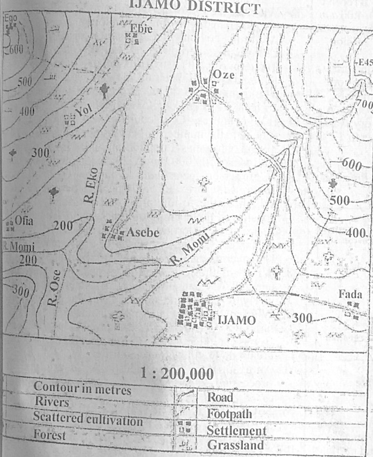
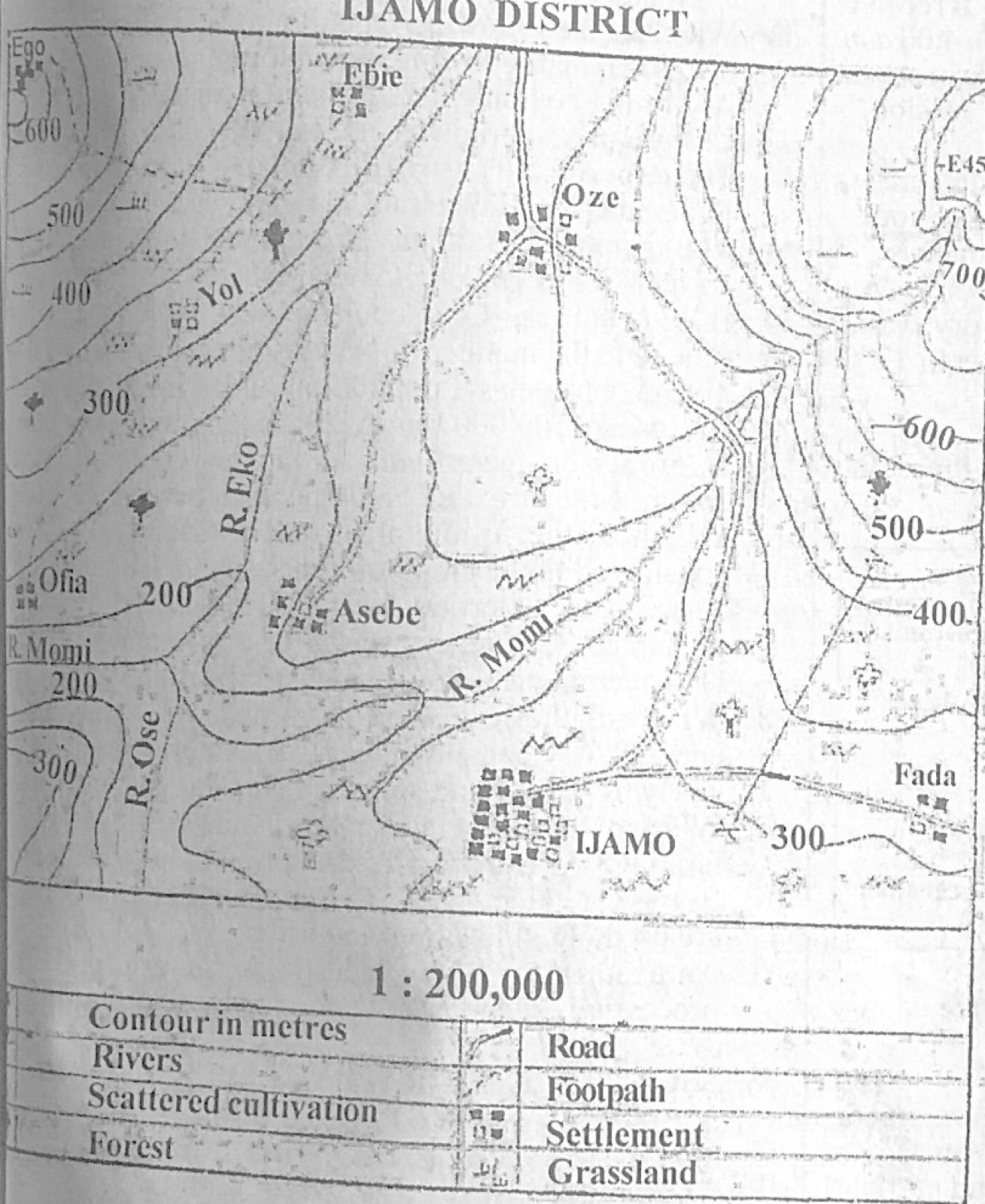
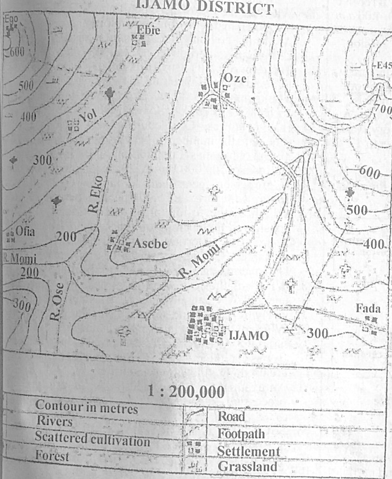
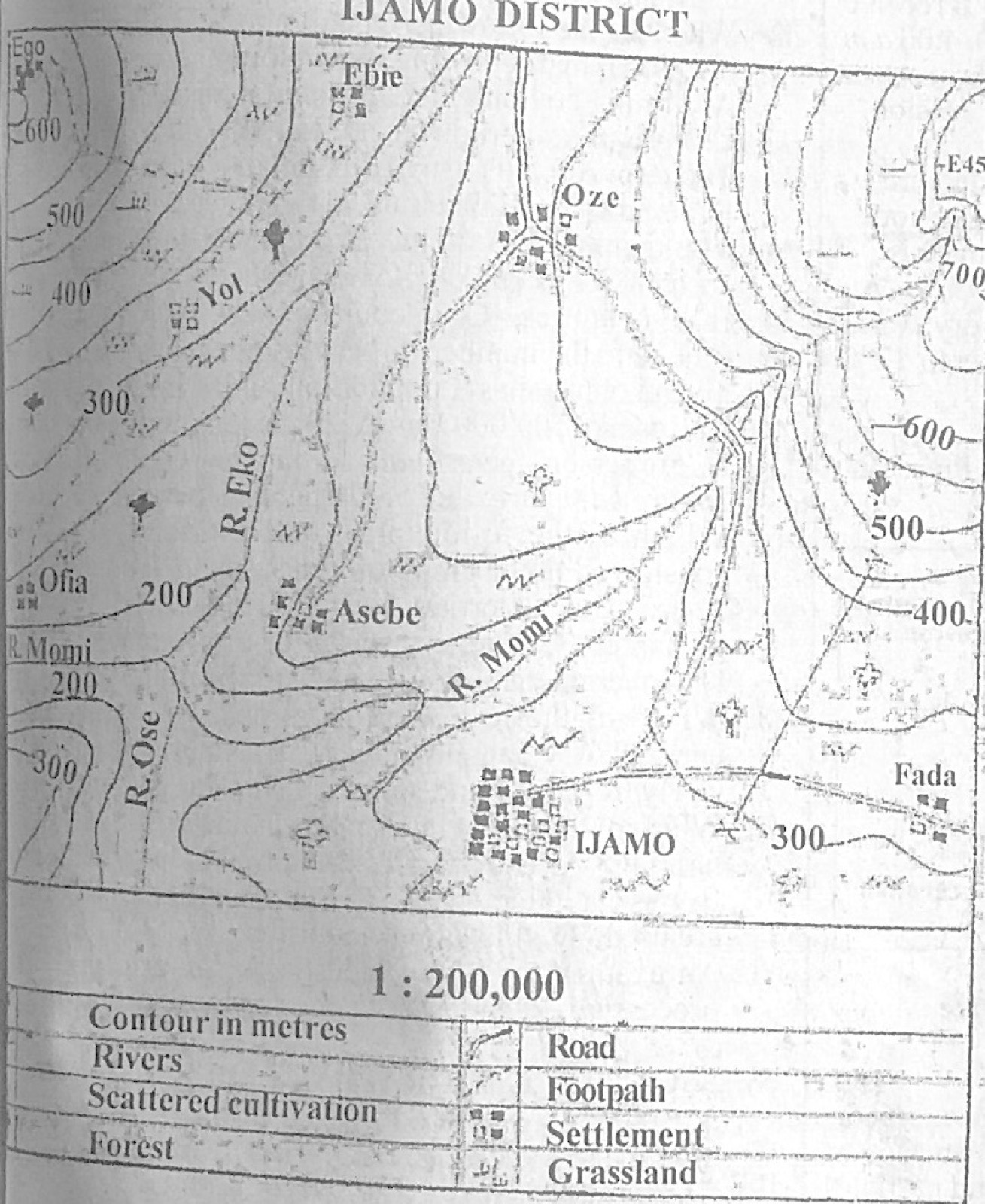
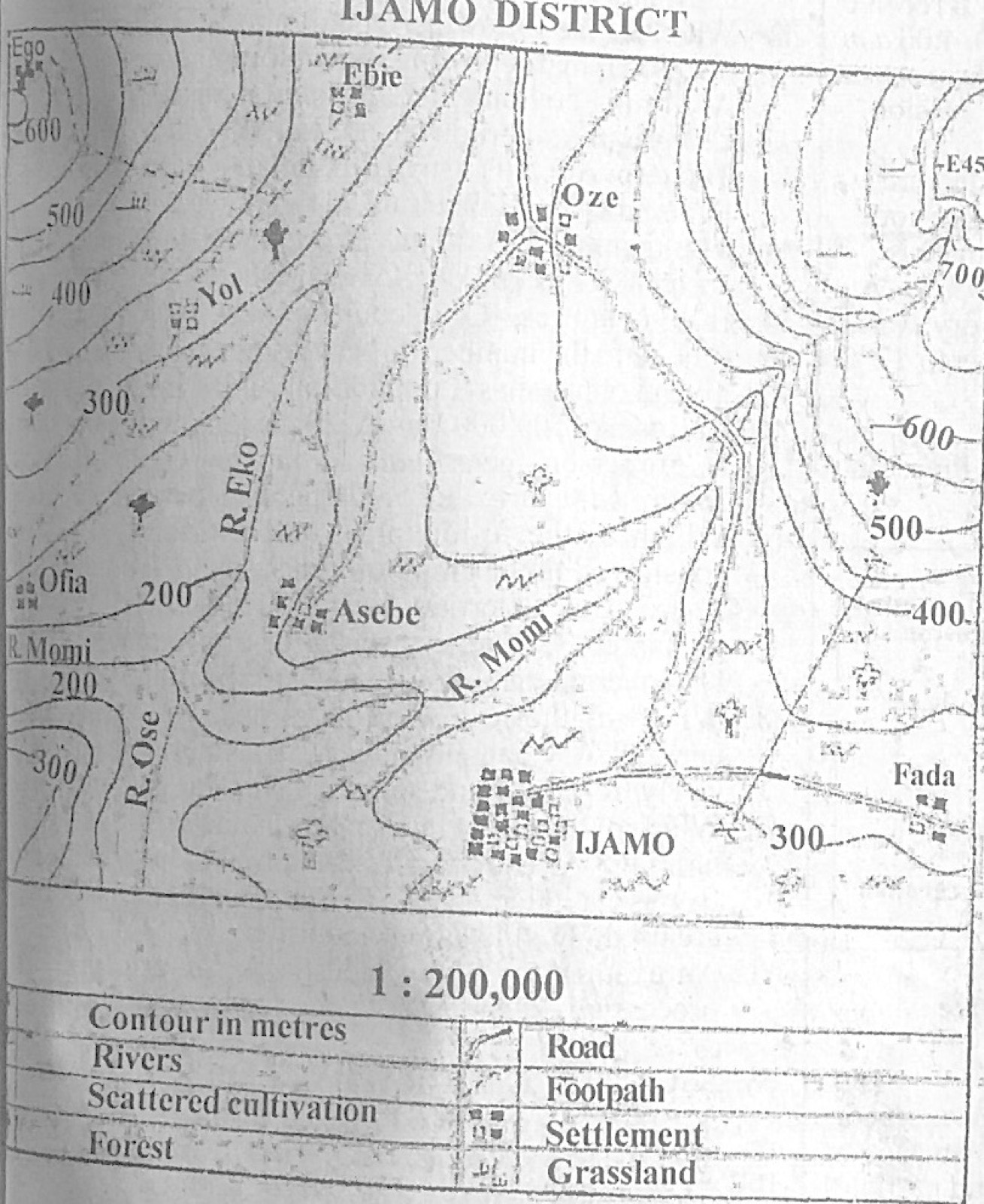
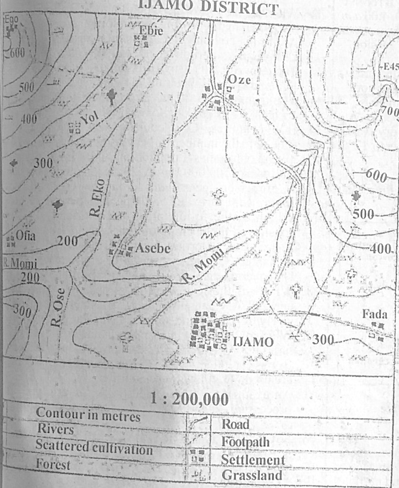
Study the map of IJAMO DISTRICT to answer this question. What will be the new scale of the map in Representative Fraction if the map is enlarged to twice its original size?
A.1 : 100,000
B.1 : 200,000
C.1 : 300,000
D.1 : 400,000
Show the answer and explanation
Answer: A (1 : 100,000)
Explanation
Doubling the map makes 1 cm stand for half the ground distance: 1 : 200,000 becomes 1 : 100,000.
The table below shows the temperature and rainfall distribution of Station Q. Use it to answer this question. Month: Jan, Feb, Mar, Apr, May, Jun, Jul, Aug, Sep, Oct, Nov, Dec Temperature (°C): 21, 24, 26, 32, 31, 29, 27, 25, 27, 27, 26, 35 Rainfall (mm): 0, 0, 11, 13, 71, 121, 211, 302, 130, 12, 0, 0 What is the annual range of temperature for Station Q?
The table below shows the temperature and rainfall distribution of Station Q. Use it to answer this question. Month: Jan, Feb, Mar, Apr, May, Jun, Jul, Aug, Sep, Oct, Nov, Dec Temperature (°C): 21, 24, 26, 32, 31, 29, 27, 25, 27, 27, 26, 35 Rainfall (mm): 0, 0, 11, 13, 71, 121, 211, 302, 130, 12, 0, 0 How many months of dry season has the station?
A.10
B.5
C.4
D.2
Show the answer and explanation
Answer: C (4)
Explanation
January, February, November and December have no rain at all: 4 months.
The table below shows the temperature and rainfall distribution of Station Q. Use it to answer this question. Month: Jan, Feb, Mar, Apr, May, Jun, Jul, Aug, Sep, Oct, Nov, Dec Temperature (°C): 21, 24, 26, 32, 31, 29, 27, 25, 27, 27, 26, 35 Rainfall (mm): 0, 0, 11, 13, 71, 121, 211, 302, 130, 12, 0, 0 The annual rainfall recorded at Station Q is
Which coastal feature has the following characteristics? I. Produced by wave erosion II. Enlarges through alternate compression and expansion of air III. Connects the top of the cliff to the sea IV. Has narrow, chimney-like opening
A.Blow hole
B.Tombolo
C.Beach
D.Spit
Show the answer and explanation
Answer: A (Blow hole)
Explanation
A blowhole is a vertical shaft from a sea cave to the cliff top, enlarged by compressed air.
If someone in Town A located on longitude 135°E telephones a friend in Town B located on longitude 120°W at 10.00 a.m, at what time will his friend in Town B receive the call?
A.5:00 a.m
B.5:00 p.m
C.4:00 p.m
D.4:00 a.m
Show the answer and explanation
Answer: B (5:00 p.m)
Explanation
Difference = 135 + 120 = 255° × 4 min = 1,020 min = 17 hours; B is west, so its time is behind: 10.00 a.m. − 17 h = 5.00 p.m. (the previous day).
Which of the following pairs are reasons for establishing industries in urban centres? I. Employment II. Revenue generation III. Religious tolerance IV. Unemployment creation
A.I and II only
B.II and IV only
C.III and IV only
D.I and IV only
Show the answer and explanation
Answer: A (I and II only)
Explanation
Industries are set up to provide jobs and generate revenue.
The membership of the Economic Community of West African States (ECOWAS) consists of
A.12 countries
B.13 countries.
C.15 countries.
D.16 countries.
Show the answer and explanation
Answer: A (12 countries)
Explanation
ECOWAS had 15 member countries until January 2025, when Mali, Burkina Faso and Niger left. It now has 12 members, including Nigeria, Ghana, Senegal and Côte d'Ivoire.
(a) Highlight five characteristics of urban settlements in developing countries. (b) Explain five ways in which urban settlements depend on their surrounding rural settlements in developing countries.
Show the model answer
Model answer
(a) Large population and high density; mainly secondary and tertiary occupations; many social amenities; heterogeneous population; compact (nucleated) built-up area; modern buildings; slums and squatter settlements; traffic congestion; pollution; administrative and commercial functions. (b) Rural areas supply food; raw materials for urban industries; labour (migrants); building materials (sand, timber); fuel wood and charcoal; market for manufactured goods; recreation and tourist sites; land for urban expansion.
(a) Define the term balance of trade. (b) Outline five factors that promote trade between Tropical Africa and the developed world. (c) Highlight four benefits of international trade to the economy of Tropical Africa.
Show the model answer
Model answer
(a) Balance of trade is the difference between the value of a country's visible exports and the value of its visible imports over a period, usually a year. (b) Differences in natural resources and climate; Africa produces raw materials needed by developed industries; Africa needs manufactured goods and technology; colonial and historical ties; trade agreements and economic blocs; good shipping and communication links; foreign investment; need for foreign exchange. (c) Foreign exchange earnings; access to goods not produced locally; employment; government revenue; transfer of technology and ideas; stimulates production and specialisation; foreign investment; international cooperation.
(a) What is pipeline transportation? (b) List two products transported by pipeline. (c) Outline four: (i) advantages of pipeline transportation in Tropical African countries; (ii) problems created by pipeline transportation in Tropical African countries.
Show the model answer
Model answer
(a) Pipeline transportation is the movement of liquids, gases or slurries over long distances through pipes. (b) Crude oil; refined petroleum products (petrol, kerosene, diesel); natural gas; water; slurries (e.g. coal or cement). (c)(i) Continuous, reliable flow; cheap to run once built; not affected by weather or terrain; reduces road traffic and accidents; safe for inflammable products; needs little labour. (ii) High cost of construction; vandalism and theft (pipeline sabotage); oil spills polluting land and water; fire and explosions; displacement of people and loss of farmland; carries only liquids and gases; costly monitoring and maintenance.
(a) Draw an outline map of Nigeria. On the map, show and name: (i) one area that receives an annual rainfall of 2,000 mm - 3,000 mm; (ii) one area noted for the Sub-equatorial climate; (iii) one important town in 4(a)(ii). (b) Identify four factors that affect the distribution of rainfall in Nigeria. (c) Outline three characteristics of the Sub-equatorial climate in Nigeria.
Show the model answer
Model answer
(a) Outline of Nigeria with title, key and north arrow; a 2,000-3,000 mm belt along the south (e.g. Lagos to Port Harcourt/Calabar coastal area); the sub-equatorial belt across the south; a town in it such as Lagos, Warri, Port Harcourt, Calabar or Owerri. (b) Latitude/distance from the sea; movement of the ITCZ and the two air masses (south-west and north-east winds); relief (e.g. Jos Plateau, eastern highlands); ocean currents; direction of the coast; vegetation. (c) Heavy rainfall over 2,000 mm; double maxima with a short 'August break'; rain in most months, short dry season; high temperatures (about 27°C) with small annual range (2-3°C); high humidity; heavy cloud cover.
(a) Outline five factors that promote the cultivation of cocoa in Nigeria. (b) Identify five solutions to the problems that limit the cultivation of cocoa in Nigeria.
Show the model answer
Model answer
(a) Rainfall of 1,250-2,000 mm well spread through the year; high temperature (about 27°C); deep, well-drained loamy soils; shade for young plants; gently undulating land; cheap labour; good transport to ports; research and extension (CRIN); ready world market. (b) Supply improved, disease-resistant seedlings; control pests and diseases (black pod, capsids) with subsidised chemicals; credit and loans for farmers; replant old farms; better prices and marketing boards; extension services; land tenure reform; better rural roads and storage; encourage young people into farming; cooperatives.
(a) Draw an outline map of Nigeria. On the map, locate and name: (i) one area noted for high population density; (ii) Abuja. (b) Outline five reasons that have accounted for the high population density in 6(a)(i). (c) Country Z has a population of 140,000,000 and a total land area of 350,000 km². Calculate the population density of Country Z.
Show the model answer
Model answer
(a) Outline of Nigeria with title and north arrow; a densely populated area such as Lagos, the Kano close-settled zone, the Igbo heartland (Anambra/Imo) or the Ibadan-Oyo area; Abuja in the centre. (b) (for the area chosen) Fertile soils; favourable climate; employment in industries and commerce; administrative headquarters; early contact with Europeans and old kingdoms; good transport; social amenities; rural-urban migration; high birth rate; security. (c) Density = 140,000,000 ÷ 350,000 = 400 persons per km².
The Table C below shows the value of imported commodities by a country in the years 2016 to 2020. Study and use it to answer the questions that follow. Table C (value of imported commodities in million Naira) 2016: 80 2017: 120 2018: 240 2019: 60 2020: 300 (a) Using a vertical scale of 2 cm to represent 40 million units of the value of imported commodities, construct a divergent bar graph to represent the data (b) State two disadvantages of divergent bar graphs.
Show the model answer
Model answer
(a) Mean = (80 + 120 + 240 + 60 + 300) ÷ 5 = 800 ÷ 5 = 160 million. Deviations: 2016 −80; 2017 −40; 2018 +80; 2019 −100; 2020 +140. Draw a horizontal base line for the mean (160); bars above for 2018 (4 cm) and 2020 (7 cm) and below for 2016 (4 cm), 2017 (2 cm) and 2019 (5 cm); equal widths, labelled years, axis, title and key. (b) The actual values are not shown directly; calculating the mean and deviations takes time; difficult to read exact values; not suitable for many items; the base (mean) changes with the data, so graphs are hard to compare.
(a) Define the term lithosphere. (b) State three characteristics of the lithosphere. (c) Outline five benefits of the lithosphere.
Show the model answer
Model answer
(a) The lithosphere is the solid outer layer of the earth, made up of the crust and the uppermost part of the mantle. (b) Made of rocks and soil; consists of continental crust (sial) and oceanic crust (sima); thickness about 5-70 km (thicker under continents); broken into tectonic plates; has landforms such as mountains, plains and plateaus. (c) Land for settlement and buildings; soil for agriculture; minerals and fossil fuels; building materials (sand, stone, clay); habitat for plants and animals; stores groundwater; tourism (landscapes); supports roads and other infrastructure.
(a) What is an artesian well? (b) Highlight four conditions that favour the formation of an artesian well. (c) Outline two usefulness of an artesian well.
Show the model answer
Model answer
(a) An artesian well is a well from which water rises to the surface by its own pressure, from a permeable layer trapped between impermeable layers. (b) A permeable rock layer (aquifer) sandwiched between two impermeable layers; the layers form a basin (syncline); the aquifer is exposed at the edges in a rainy area where water can enter; the well is sunk at a point lower than the intake area; adequate rainfall; the aquifer is not broken by faults that let water escape. (c) Water for domestic use; irrigation; water for livestock (e.g. Great Artesian Basin, Australia); water for industry; supply in dry areas.
(a) State one difference between weather and climate. (b) With the aid of a diagram describe the mode of formation of cyclonic rainfall. (c) Highlight three benefits of cyclonic rainfall.
Show the model answer
Model answer
(a) Weather is the condition of the atmosphere at a place over a short time, while climate is the average weather of a place over a long period (about 35 years). (b) Diagram: warm air mass meeting cold air mass along a front, warm air rising over the wedge of cold air, clouds and rain at the front. Two air masses of different temperature and humidity meet; the lighter warm air is forced to rise over the denser cold air; it cools as it rises, reaches dew point and condenses into clouds; rain falls along the front (frontal/cyclonic rain), usually as long periods of steady rain. (c) Water for agriculture; replenishes rivers, lakes and groundwater; water for domestic and industrial use; supports vegetation and wildlife; hydroelectric power; cools the weather.
(a) What is a flood plain? (b) With the aid of a diagram, describe the characteristics and mode of formation of a flood plain.
Show the model answer
Model answer
(a) A flood plain is the wide, flat land on both sides of a river in its lower course, built of alluvium deposited when the river floods. (b) Diagram: cross-section of a river with levees and a broad flat valley floor bounded by bluffs. Characteristics: flat, low-lying land; made of fertile alluvium; found in the lower course on both banks; bounded by bluffs; often has meanders, ox-bow lakes and levees; floods in the rainy season. Formation: in the lower course the river is slow and carries much load; in the rainy season it overflows its banks; the floodwater spreads out and slows down, depositing silt over the valley floor; repeated floods build up layers of alluvium; meander migration widens the plain.
(a) List three processes of wind erosion. (b) Highlight three: (i) similarities between a zeugen and a yardang. (ii) differences between a zeugen and a yardang.
Show the model answer
Model answer
(a) Deflation; abrasion (corrasion); attrition. (b)(i) Similarities: both are formed by wind erosion; both are found in hot deserts; both develop where hard and soft rocks occur together; both are ridges separated by furrows; both are shaped by abrasion. (ii) Differences: in a zeugen the hard and soft rock layers lie horizontally, in a yardang they lie vertically; a zeugen has a flat (tabular) top, a yardang a steep, ridged top; zeugen ridges lie at right angles (or any direction) to the wind, yardangs lie parallel to the wind; zeugens are separated by deep furrows, yardangs by long narrow corridors.
(a) Define natural environment. (b) Highlight four ways by which mankind destroys the natural environment. (c) Outline two measures that can be adopted to control the destruction of the natural environment.
Show the model answer
Model answer
(a) The natural environment is the surroundings that exist without human creation: land, water, air, climate, soils, plants and animals. (b) Deforestation and bush burning; mining and quarrying; pollution of air, water and land (industrial waste, oil spills, refuse); overgrazing and poor farming practices causing erosion; urbanisation and construction; poaching and overhunting. (c) Afforestation and reafforestation; enforcement of environmental laws; reclamation of mining sites; proper waste management and recycling; public education; controlled grazing and good farming practices; population control.