WAEC Geography 2022 past questions and answers

57 questions. Try each one, then open the answer to check yourself and read the explanation.

Question 1

Map Scale, Distance and Direction

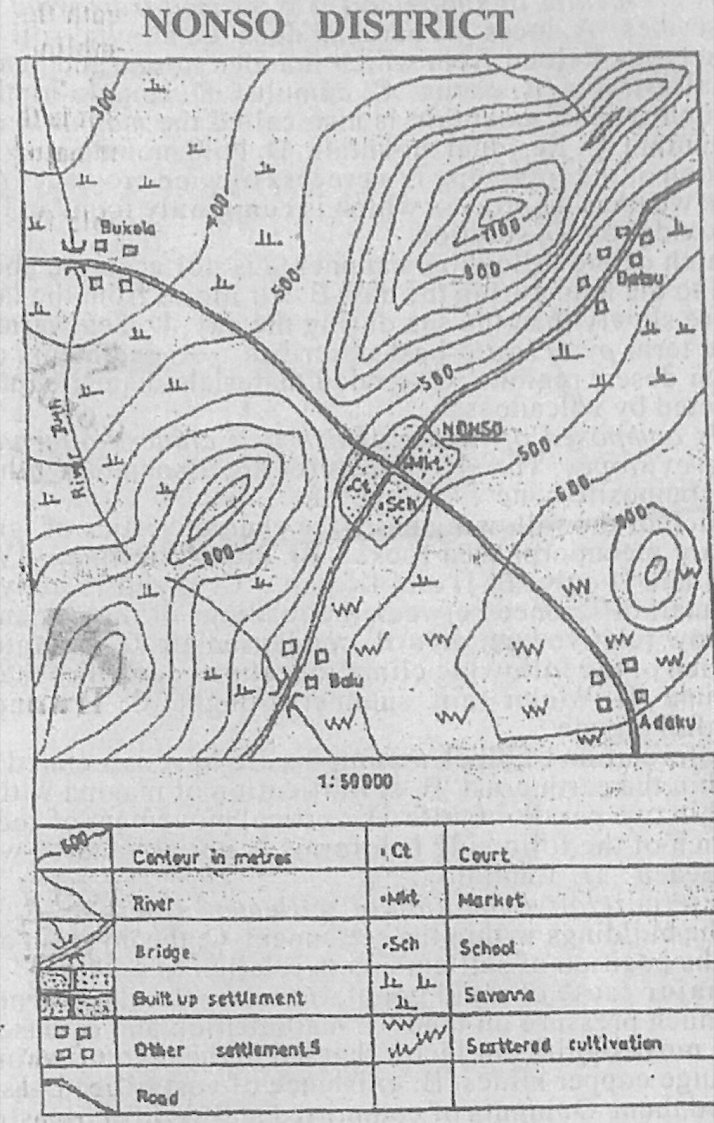
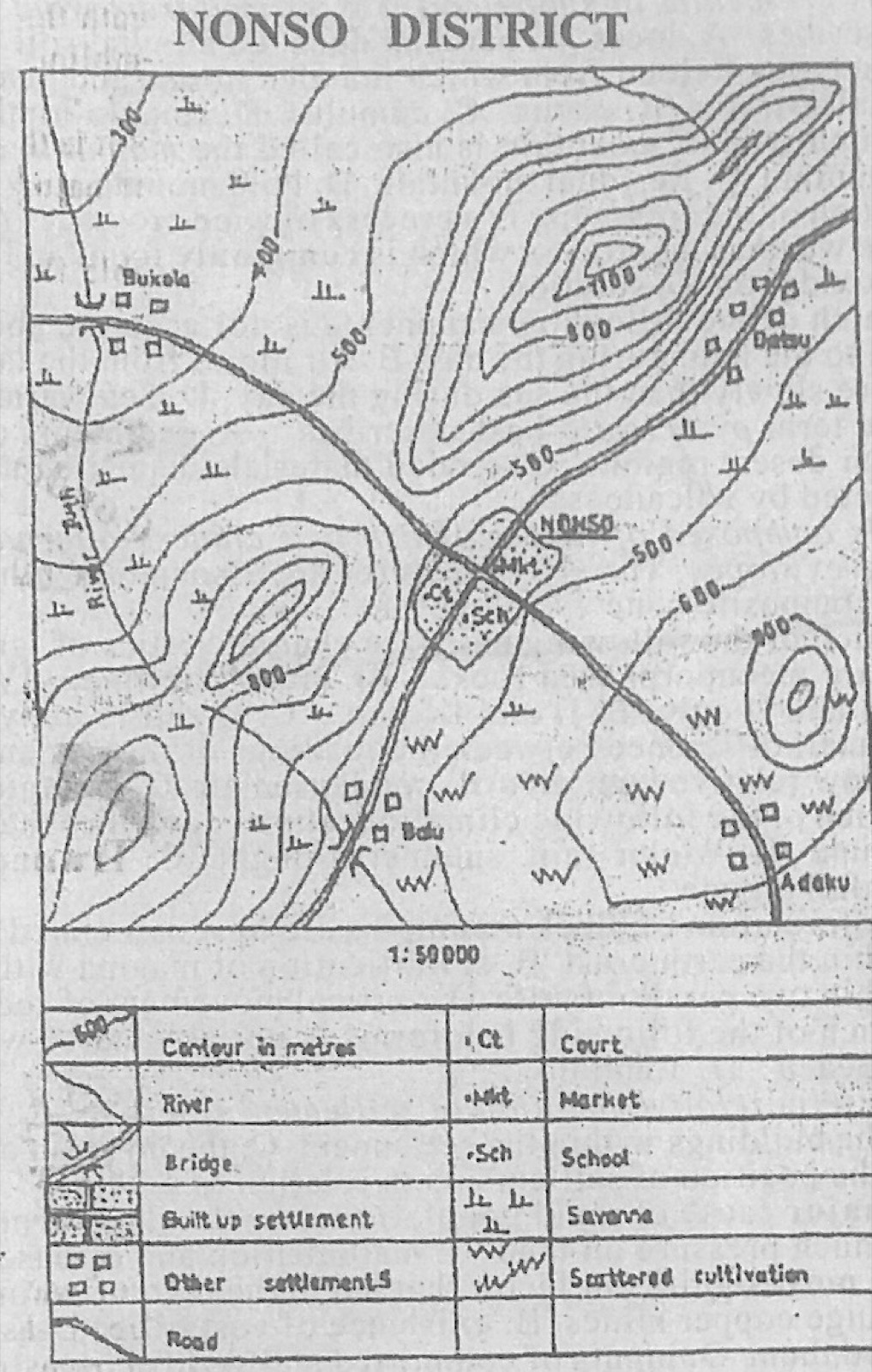
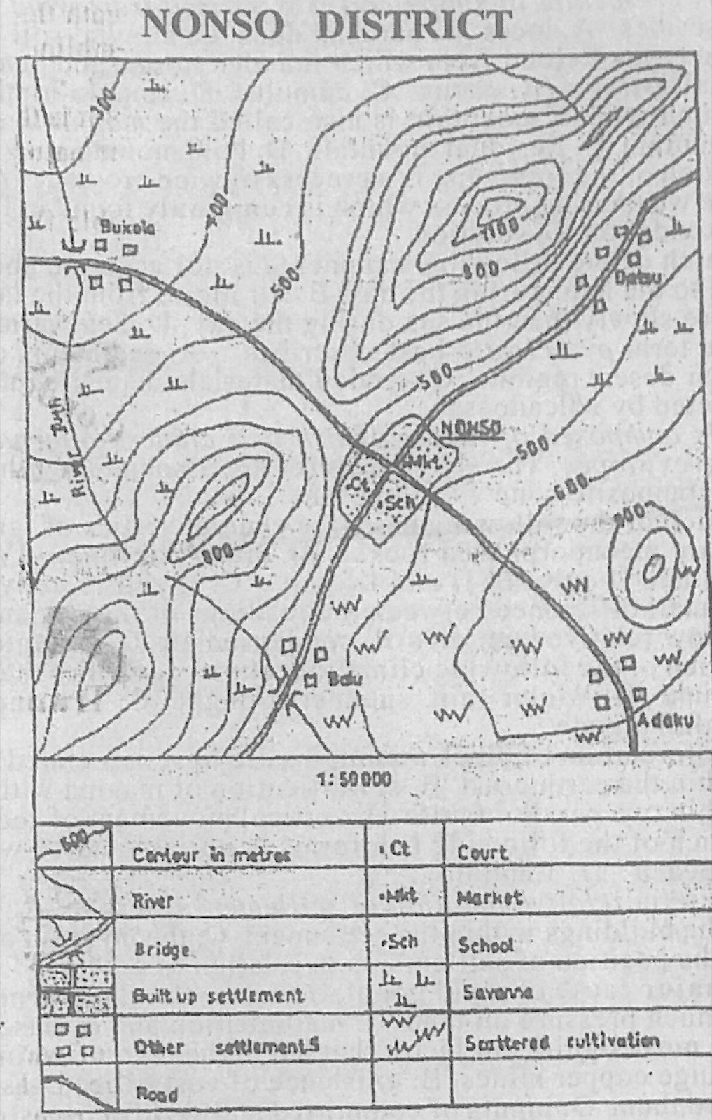
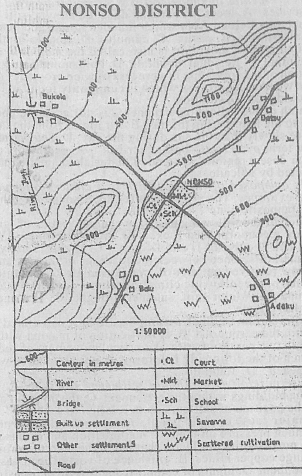
Study the map of NONSO DISTRICT to answer this question. What is the scale of the map in statement form?

Diagram for this question
  1. A.One centimetre on the map represents ½ kilometre on the ground
  2. B.One centimetre on the map represents 1 kilometre on the ground
  3. C.One centimetre on the map represents 2 kilometres on the ground
  4. D.One centimetre on the map represents 5 kilometres on the ground
Show the answer and explanation

Answer: A (One centimetre on the map represents ½ kilometre on the ground)

Explanation

The map is 1:50 000, so 1 cm stands for 50,000 cm = 0.5 km.

Open this question

Question 2

Relief and Map Interpretation

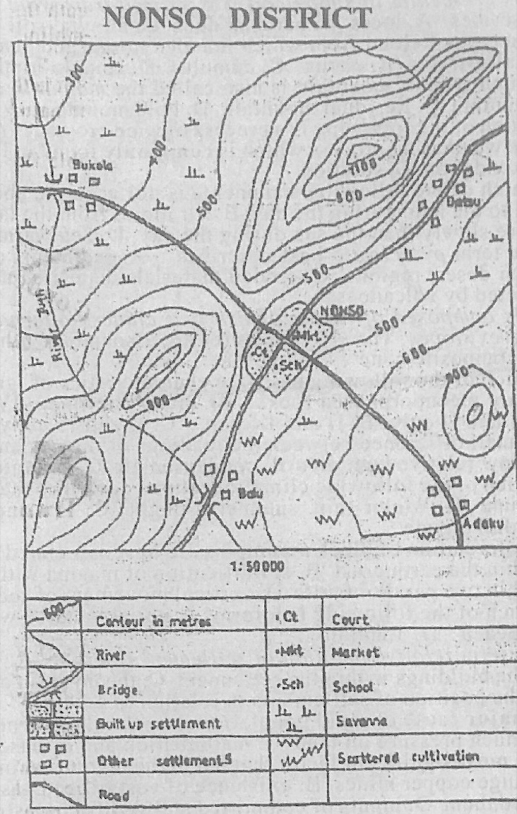
Study the map of NONSO DISTRICT to answer this question. The growth of NONSO settlement is probably because

Diagram for this question
  1. A.NONSO settlement has a court
  2. B.NONSO is situated at the foot of a ridge
  3. C.NONSO is a port town
  4. D.NONSO is a nodal town
Show the answer and explanation

Answer: D (NONSO is a nodal town)

Explanation

The two main roads of the district cross at NONSO, making it a nodal town that attracts trade and people.

Open this question

Question 3

Relief and Map Interpretation

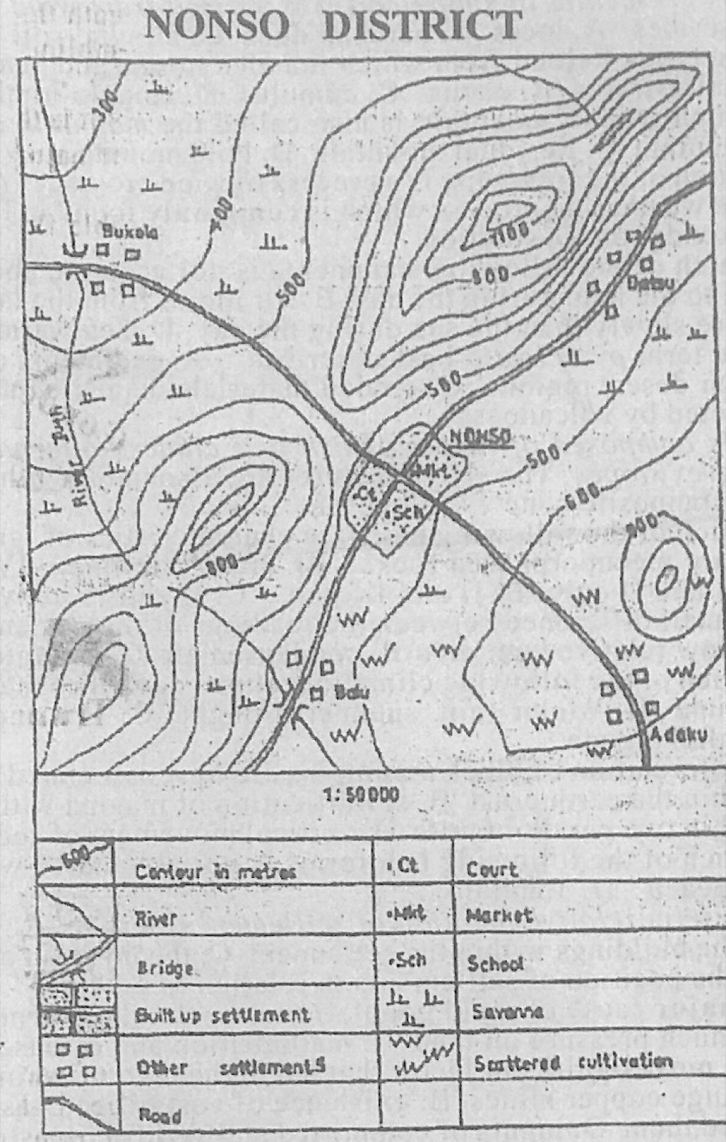
Study the map of NONSO DISTRICT to answer this question. The highest spot on the mapped area is approximately

Diagram for this question
  1. A.1300 metres
  2. B.1250 metres
  3. C.1150 metres
  4. D.1050 metres
Show the answer and explanation

Answer: B (1250 metres)

Explanation

The highest hill in the north has a small closed contour inside the 1100 m ring (the 1200 m contour), so its top is about 1250 m.

Open this question

Question 5

Relief and Map Interpretation

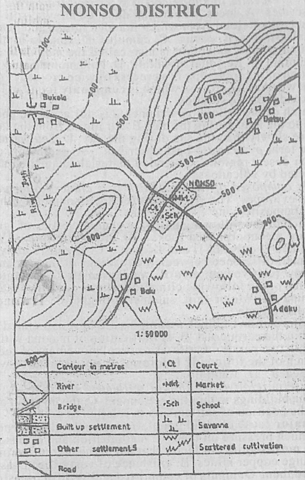
Study the map of NONSO DISTRICT to answer this question. The commercial centre in the mapped area is

Diagram for this question
  1. A.NONSO
  2. B.Adaku
  3. C.Bukola
  4. D.Balu
Show the answer and explanation

Answer: A (NONSO)

Explanation

Only NONSO has a market (Mkt), so it is the commercial centre.

Open this question

Question 6

Relief and Map Interpretation

Study the map of NONSO DISTRICT to answer this question. The watershed in the mapped area is situated

Diagram for this question
  1. A.on the plain
  2. B.along the pass
  3. C.on spurs
  4. D.on the ridge
Show the answer and explanation

Answer: D (on the ridge)

Explanation

A watershed is the high ground that separates streams flowing in different directions; here it follows the crest of the ridges.

Open this question

Question 7

Map Scale, Distance and Direction

Study the map of NONSO DISTRICT to answer this question. If the map is reduced by half its original size, what would be the scale of the new map?

Diagram for this question
  1. A.1:25,000
  2. B.1:50,000
  3. C.1:100,000
  4. D.1:150,000
Show the answer and explanation

Answer: C (1:100,000)

Explanation

Halving the map makes each ground distance half as long on paper, so 1:50,000 becomes 1:100,000.

Open this question

Question 8

Relief and Map Interpretation

Study the map of NONSO DISTRICT to answer this question. What is the direction of flow of River Juth?

Diagram for this question
  1. A.Northeast
  2. B.Northwest
  3. C.Southeast
  4. D.Southwest
Show the answer and explanation

Answer: B (Northwest)

Explanation

River Juth runs from the hills near Balu towards the 300 m land near Bukola in the north-west, so it flows north-westwards.

Open this question

Question 9

Relief and Map Interpretation

Study the map of NONSO DISTRICT to answer this question. What is the contour interval on the mapped area?

Diagram for this question
  1. A.50 metres
  2. B.100 metres
  3. C.200 metres
  4. D.300 metres
Show the answer and explanation

Answer: B (100 metres)

Explanation

Contours are labelled 300, 400, 500, 600, 800, 900 and 1100 m with one line between each, so the interval is 100 m.

Open this question

Question 10

Relief and Map Interpretation

Study the map of NONSO DISTRICT to answer this question. Which of the following settlements is nucleated?

Diagram for this question
  1. A.Bukola
  2. B.Datsu
  3. C.Adaku
  4. D.NONSO
Show the answer and explanation

Answer: D (NONSO)

Explanation

NONSO is a compact built-up settlement clustered round the road junction; the others are scattered huts.

Open this question

Question 11

Statistical Maps and Diagrams

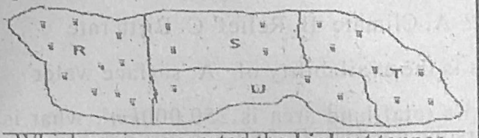
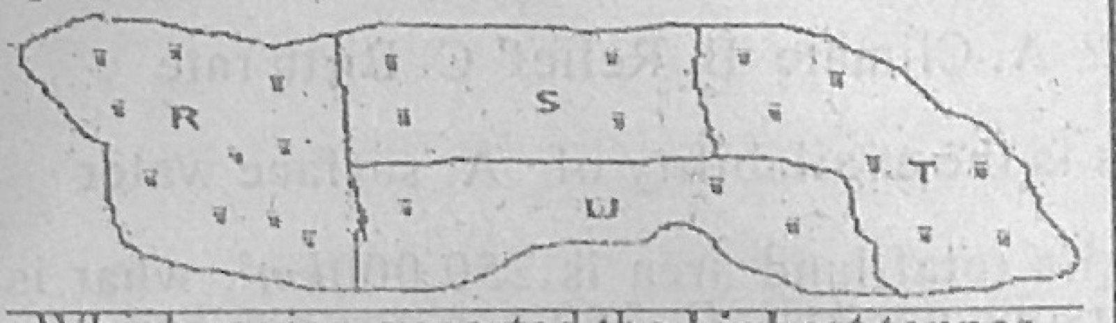
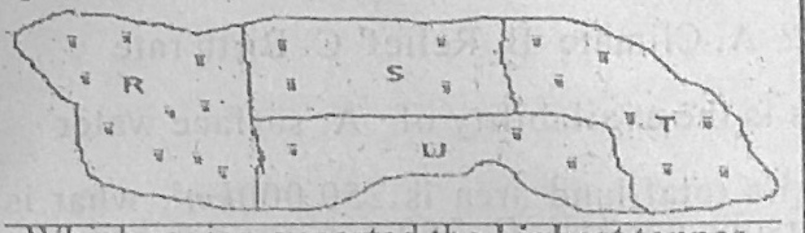
Figure 1 represents the export of rice by four regions in Country XX in the year 2009. One dot represents 20,000 tonnes of exported rice was used as the scale of the dot map. Study the dot map to answer this question. Which region exported the highest tonnes of rice?

Diagram for this question
  1. A.R
  2. B.U
  3. C.S
  4. D.T
Show the answer and explanation

Answer: A (R)

Explanation

Region R has the most dots (10 dots = 200,000 tonnes).

Open this question

Question 12

Statistical Maps and Diagrams

Figure 1 represents the export of rice by four regions in Country XX in the year 2009. One dot represents 20,000 tonnes of exported rice was used as the scale of the dot map. Study the dot map to answer this question. By how much tonnes was the export of rice from region T higher than that from region U?

Diagram for this question
  1. A.20,000
  2. B.40,000
  3. C.60,000
  4. D.80,000
Show the answer and explanation

Answer: D (80,000)

Explanation

T has 7 dots and U has 3 dots: 4 dots × 20,000 = 80,000 tonnes.

Open this question

Question 13

Statistical Maps and Diagrams

Figure 1 represents the export of rice by four regions in Country XX in the year 2009. One dot represents 20,000 tonnes of exported rice was used as the scale of the dot map. Study the dot map to answer this question. The total export of rice for regions R and T is

Diagram for this question
  1. A.180,000 tonnes
  2. B.210,000 tonnes
  3. C.260,000 tonnes
  4. D.340,000 tonnes
Show the answer and explanation

Answer: D (340,000 tonnes)

Explanation

R (10 dots) + T (7 dots) = 17 dots × 20,000 = 340,000 tonnes.

Open this question

Question 14

Underground Water and Karst

The sharp pillars hanging from the roof of a cavern in limestone regions are called

  1. A.dolines
  2. B.stalagmites
  3. C.uvalas
  4. D.stalactites
Show the answer and explanation

Answer: D (stalactites)

Explanation

Stalactites hang down from the cave roof; stalagmites grow up from the floor.

Open this question

Question 15

Latitude, Longitude and Time

Two towns, P and Q, are on the International Date Line and in the same hemisphere. If the distance between the two towns is 444km and town P is located on latitude 3°N, on what latitude is town Q located?

  1. A.10°N
  2. B.7°N
  3. C.4°N
  4. D.1°N
Show the answer and explanation

Answer: B (7°N)

Explanation

1° of latitude ≈ 111 km, so 444 km = 4°. Q is 4° from P in the same (northern) hemisphere: 3° + 4° = 7°N (3° − 4° would be south of the equator).

Open this question

Question 17

Weather

Lines drawn on maps joining places with equal amount of cloud cover are called

  1. A.isohyets
  2. B.isobars
  3. C.isonephs
  4. D.contours
Show the answer and explanation

Answer: C (isonephs)

Explanation

Isonephs join places with the same cloudiness; isohyets join equal rainfall and isobars equal pressure.

Open this question

Question 18

Latitude, Longitude and Time

Which of the following statements is accurate?

  1. A.There is a distance of 111km for every 1° of latitudinal difference
  2. B.A time difference of 4 minutes exists for every 15° of longitude
  3. C.Any two opposite lines of latitudes make a Great Circle
  4. D.The sun is overhead at noon at Tropic of Cancer on December 22.
Show the answer and explanation

Answer: A (There is a distance of 111km for every 1° of latitudinal difference)

Explanation

One degree of latitude is about 111 km. 4 minutes is for 1° of longitude (1 hour for 15°), and on 22 December the sun is over the Tropic of Capricorn.

Open this question

Question 19

Coastal Landforms

Which of the following coastal features is not due to erosion?

  1. A.Bay
  2. B.Cliff
  3. C.Beach
  4. D.Arch
Show the answer and explanation

Answer: C (Beach)

Explanation

A beach is built from sand and pebbles deposited by waves; bays, cliffs and arches are carved by erosion.

Open this question

Question 20

Rivers and River Landforms

In its old stage, a river would I. be interrupted by waterfalls and rapids II. flow sluggishly and develop pronounced meanders III. flow fast and have truncated spurs IV. develop levees and have a flood plain

  1. A.II and IV only
  2. B.II and III only
  3. C.I and II only
  4. D.III and IV only
Show the answer and explanation

Answer: A (II and IV only)

Explanation

In old age a river flows slowly over a flat plain, meandering widely and building levees and flood plains; waterfalls and fast flow belong to the youthful stage.

Open this question

Question 21

The Earth and Solar System

The movement of the earth that causes variation in the lengths of the day and night is

  1. A.traction
  2. B.revolution
  3. C.rotation
  4. D.coriolis
Show the answer and explanation

Answer: B (revolution)

Explanation

As the tilted earth revolves round the sun, each hemisphere leans towards or away from the sun, so the lengths of day and night change through the year. Rotation alone causes day and night, not their variation.

Open this question

Question 22

Wind and Desert Landforms

It is crescentic in shape and it is formed from wind deposition in arid region. The statement above describes

  1. A.loess
  2. B.barchan dune
  3. C.alluvial soil
  4. D.silty soil
Show the answer and explanation

Answer: B (barchan dune)

Explanation

A barchan is a crescent-shaped sand dune deposited by wind in deserts.

Open this question

Question 23

Weather

The type of cloud from which thunder storms and heavy rain are experienced in the Tropics is

  1. A.altostratus
  2. B.cirrus
  3. C.cumulus
  4. D.cumulo-nimbus
Show the answer and explanation

Answer: D (cumulo-nimbus)

Explanation

Cumulonimbus clouds are tall, dark storm clouds that bring thunder, lightning and heavy rain.

Open this question

Question 24

Earth Movements and Vulcanicity

Which type of mountain is also called the mountain of denudation?

  1. A.Block mountain
  2. B.Volcanic mountain
  3. C.Residual mountain
  4. D.Fold mountain
Show the answer and explanation

Answer: C (Residual mountain)

Explanation

Residual mountains are the remains of older highlands worn down by denudation.

Open this question

Question 25

Wind and Desert Landforms

Which of the following is a process of wind erosion?

  1. A.Deflation
  2. B.Saltation
  3. C.Solution
  4. D.Traction
Show the answer and explanation

Answer: A (Deflation)

Explanation

Deflation is the removal of loose sand and dust by wind; saltation and traction are ways of transporting load.

Open this question

Question 26

Weathering, Erosion and Mass Movement

The weathering process which is commonly found in limestone regions is

  1. A.hydrolysis
  2. B.exfoliation
  3. C.oxidation
  4. D.solution
Show the answer and explanation

Answer: D (solution)

Explanation

Rainwater containing carbon dioxide dissolves limestone (carbonation-solution).

Open this question

Question 27

Weather

Which of the following statements is not accurate about sea and land breeze?

  1. A.Air blows from the sea to the land during the day
  2. B.Air blows from the land to the sea during the night
  3. C.Land warms up more slowly than the sea during the day
  4. D.Sea warms up more slowly than the land during the day
Show the answer and explanation

Answer: C (Land warms up more slowly than the sea during the day)

Explanation

Land heats up faster than the sea by day, so statement C is wrong.

Open this question

Question 28

Earth Movements and Vulcanicity

The term pyroclastic best describes

  1. A.sediments accumulated in deep sea
  2. B.a wind-blown sand from desert regions
  3. C.eroded materials deposited at the mouth of a river
  4. D.fragmented materials ejected by volcanoes
Show the answer and explanation

Answer: D (fragmented materials ejected by volcanoes)

Explanation

Pyroclastic ('fire-broken') material is ash, cinders and rock fragments blown out of a volcano.

Open this question

Question 29

Earth Movements and Vulcanicity

It is composed of layers of ash and cinders alternating with lava. It has a broad base and steep convex slopes. The above features are associated with a

  1. A.batholith
  2. B.laccolith
  3. C.shield volcano
  4. D.composite cone
Show the answer and explanation

Answer: D (composite cone)

Explanation

Alternating layers of ash and lava build a composite (strato) cone.

Open this question

Question 30

Rocks

Which of the following pairs are characteristics of igneous rocks? They I. are stratified II. are metamorphosed rocks III. are crystalline IV. originate from molten magma

  1. A.I and II only
  2. B.II and III only
  3. C.II and IV only
  4. D.III and IV only
Show the answer and explanation

Answer: D (III and IV only)

Explanation

Igneous rocks form when magma cools, so they are crystalline; stratification belongs to sedimentary rocks.

Open this question

Question 31

Weather

A small difference between the readings of the wet and dry bulb thermometers is an indication of

  1. A.low relative humidity
  2. B.condensed air
  3. C.saturated air
  4. D.high relative humidity
Show the answer and explanation

Answer: D (high relative humidity)

Explanation

When the air is moist little water evaporates from the wet bulb, so it cools only slightly: a small difference means high relative humidity.

Open this question

Question 32

Climate

Which of the following climatic features describes the Equatorial climate?

  1. A.Double maxima rainfall regime
  2. B.Winter rain, summer drought
  3. C.Hot and dry throughout the year
  4. D.Single maximum rainfall regime
Show the answer and explanation

Answer: A (Double maxima rainfall regime)

Explanation

Equatorial regions get two rainfall peaks, after the two equinoxes.

Open this question

Question 33

Earth Movements and Vulcanicity

The formation of block mountains are best associated with

  1. A.accumulation of materials ejected from within the earth crust
  2. B.solidification of magma within the earth's crust
  3. C.uplifting of crustal block within two parallel faults
  4. D.vertical movement of sediments into geosynclines
Show the answer and explanation

Answer: C (uplifting of crustal block within two parallel faults)

Explanation

A block mountain (horst) is a block of crust pushed up between two parallel faults.

Open this question

Question 34

Coastal Landforms

Which of the following landforms is not associated with an advancing shoreline?

  1. A.Spit
  2. B.Stack
  3. C.Beach
  4. D.Tombolo
Show the answer and explanation

Answer: B (Stack)

Explanation

Spits, beaches and tombolos are built by deposition (advancing shoreline); a stack is left by erosion.

Open this question

Question 35

Settlement

The term relative location of settlement refers to

  1. A.imaginary point of the settlement
  2. B.the nature of the buildings within the settlement
  3. C.the position of buildings in relation to other buildings
  4. D.the position of settlements in relation to others
Show the answer and explanation

Answer: D (the position of settlements in relation to others)

Explanation

Relative location describes where a settlement is compared with other places and features.

Open this question

Question 36

Population

A major cause of rapid population growth rate in Tropical Africa is

  1. A.improved transport facilities
  2. B.much pressure on land
  3. C.malnutrition and diseases
  4. D.lack of family planning
Show the answer and explanation

Answer: D (lack of family planning)

Explanation

Little use of family planning keeps birth rates high while death rates fall.

Open this question

Question 37

Manufacturing Industry

The most significant factor that led to the revolution in the Japanese industrial sector is the

  1. A.presence of huge copper mines
  2. B.existence of vast oil and gas fields
  3. C.military strength of the countries that aided them
  4. D.inputs of committed and skillful industrial workforce
Show the answer and explanation

Answer: D (inputs of committed and skillful industrial workforce)

Explanation

Japan has few minerals or oil; its industry grew on a skilled, disciplined workforce.

Open this question

Question 38

Transport, Trade and Tourism

Which of the following reasons accounts for the low traffic on rivers in Africa?

  1. A.Presence of rapids and waterfalls
  2. B.Only used for fishing
  3. C.Wide valleys
  4. D.Change of colour during rainy seasons
Show the answer and explanation

Answer: A (Presence of rapids and waterfalls)

Explanation

Rapids and waterfalls interrupt navigation on most African rivers.

Open this question

Question 39

West Africa and ECOWAS

The trade liberalization policy of ECOWAS is aimed at

  1. A.fostering unity and peace among member states
  2. B.taking a common stand on the world issues
  3. C.promoting economic integration
  4. D.ensuring cultural cooperation
Show the answer and explanation

Answer: C (promoting economic integration)

Explanation

Removing trade barriers between members is meant to integrate their economies.

Open this question

Question 40

Population

Which of the following is a factor of population growth?

  1. A.Climate
  2. B.Relief
  3. C.Birth rate
  4. D.Soil fertility
Show the answer and explanation

Answer: C (Birth rate)

Explanation

Population grows through births (and immigration); climate, relief and soil affect distribution.

Open this question

Question 41

Settlement

The least important factor in the location of settlements is the availability of

  1. A.surface water
  2. B.mineral deposits
  3. C.land for building
  4. D.fertile soil
Show the answer and explanation

Answer: B (mineral deposits)

Explanation

Every settlement needs water, building land and usually farmland; mineral deposits attract only a few mining settlements, so they matter least.

Open this question

Question 42

Population

If the total population of a country is 75,000,000 and its total land area is 250,000km², what is its population density?

  1. A.30 persons per km²
  2. B.300 persons per km²
  3. C.350 persons per km²
  4. D.500 persons per km²
Show the answer and explanation

Answer: B (300 persons per km²)

Explanation

75,000,000 ÷ 250,000 = 300 persons per km².

Open this question

Question 43

Manufacturing Industry

A major hindrance to foreign investment in Tropical African countries is

  1. A.low demand for manufactured goods
  2. B.inadequate raw materials for industries
  3. C.political instability in the countries
  4. D.inadequate capital for investment
Show the answer and explanation

Answer: C (political instability in the countries)

Explanation

Investors avoid countries where coups, conflict and policy changes put their money at risk.

Open this question

Question 47

Transport, Trade and Tourism

The best way of solving transportation problems in a cosmopolitan city is

  1. A.use of air transport system
  2. B.construction of feeder roads
  3. C.purchase of many speed boats and ships
  4. D.integrated transport system involving all modes
Show the answer and explanation

Answer: D (integrated transport system involving all modes)

Explanation

Combining road, rail, water and other modes spreads traffic and links them efficiently.

Open this question

Question 49

Manufacturing Industry

Which of the following is the leading industrial zone in the West African sub region?

  1. A.Western industrial zone of Nigeria
  2. B.Accra-Tema industrial zone of Ghana
  3. C.Freetown industrial zone of Sierra Leone
  4. D.Banjul industrial zone of The Gambia
Show the answer and explanation

Answer: A (Western industrial zone of Nigeria)

Explanation

The Lagos-Ibadan (western Nigeria) industrial zone has the largest number and variety of industries in West Africa.

Open this question

Question 50

Manufacturing Industry

Which of the following is a light industry?

  1. A.Petroleum industry
  2. B.Metallurgical industry
  3. C.Textile industry
  4. D.Shipbuilding industry.
Show the answer and explanation

Answer: C (Textile industry)

Explanation

Textiles use light raw materials and machinery and produce consumer goods: a light industry.

Open this question

Theory question 101

Transport, Trade and Tourism

(a) List four modes of transportation. (b) Outline five reasons for the construction of railways in developing countries. (c) Highlight three measures that can be taken to improve rail transportation in developing countries.

Show the model answer
Model answer

(a) Road; rail; water (inland and ocean); air; pipeline; human porterage; animals; cable/ropeway.
(b) To carry bulky goods (minerals, cash crops) from the interior to the ports; to link major towns and regions; for administration and national unity; to open up new areas for development; to move people cheaply over long distances; to encourage trade and industry; for defence and security.
(c) Buy modern locomotives and coaches; replace narrow gauge with standard gauge; extend and double the tracks; maintain tracks and rolling stock regularly; train staff; improve management and funding (or private participation); improve signalling and security.

Explanation

Five reasons, each a phrase.

Open this question

Theory question 102

Population

(a) Distinguish between urbanization and population density. (b) Highlight four problems created by urbanization in Tropical Africa. (c) In what four ways can the problems highlighted in 2(b) be solved?

Show the model answer
Model answer

(a) Urbanization is the growth in the proportion of a country's people living in towns and the growth of towns in size and number; population density is the number of people per unit area (e.g. per km²) of a place.
(b) Housing shortage and slums; unemployment; traffic congestion; pollution and poor waste disposal; overstretched water, power and health services; crime and social vices; spread of diseases.
(c) Build low-cost housing and upgrade slums; create jobs and develop rural areas to reduce migration; improve roads and mass transit; proper waste management and sanitation laws; expand water, power and health services; strengthen security; enforce town-planning laws.

Explanation

Match solutions to the problems.

Open this question

Theory question 103

Manufacturing Industry

(a) State four characteristics of local craft industries. (b) Identify three limitations of local craft industries. (c) Explain five factors that have contributed to the high volume of trade between the developed and Tropical African countries.

Show the model answer
Model answer

(a) Small scale, often in homes; use simple hand tools; use local raw materials; family or apprentice labour; small capital; low output for local markets; skills passed down generations (e.g. weaving, pottery, blacksmithing, carving).
(b) Low output and quality; little capital; simple tools and poor technology; competition from factory-made imports; small markets and poor packaging; young people not interested in learning crafts.
(c) Africa produces raw materials (cocoa, oil, minerals) needed by developed industries; Africa needs manufactured goods, machinery and technology from them; colonial ties and trade links; difference in climate and resources; foreign aid and investment tied to trade; good shipping links and ports; trade agreements (e.g. EU-ACP); African demand for foreign goods.

Explanation

Explain each factor briefly.

Open this question

Theory question 104

Nigeria: People and Economy

(a) Draw a sketch map of Nigeria. On the map, locate and name: (i) Apapa seaport; (ii) Kainji dam; (iii) Abuja. (b) Highlight four benefits derived from the Hydro-Electric Power projects in Nigeria. (c) Explain three advantages of seaports in Nigeria.

Show the model answer
Model answer

(a) Outline of Nigeria with title and north arrow; Apapa seaport at Lagos on the south-west coast; Kainji dam on the River Niger in the west; Abuja in the centre (FCT).
(b) Electricity for homes and industries; water for irrigation; fishing in the reservoirs; navigation; flood control; tourism and recreation; employment; water supply to towns.
(c) Handle imports and exports, promoting international trade; earn revenue (duties, port charges); provide employment; encourage growth of industries and towns near the port; link Nigeria to other countries; serve landlocked neighbours.

Explanation

Explain each advantage in a sentence.

Open this question

Theory question 105

Agriculture, Fishing and Lumbering

(a) List two crops that are cultivated under the bush fallowing system of farming in Nigeria. (b) Outline five characteristics of bush fallowing system of farming in Nigeria. (c) Highlight four disadvantages of bush fallowing system of farming in Nigeria.

Show the model answer
Model answer

(a) Yam; cassava; maize; guinea corn; millet; cocoyam; groundnut; beans.
(b) Land is cleared by slash and burn; farmed for a few years then left to rest (fallow) while another plot is used; the settlement is permanent; simple tools (hoe, cutlass); family labour; small farms; mainly food crops for subsistence; little or no fertilizer; low yields; needs plenty of land and low population density.
(c) Wastes land as much lies fallow; low output; burning destroys organic matter and soil organisms; exposes soil to erosion; cannot work where population is dense; difficult to mechanise; destruction of forest; low income for farmers.

Explanation

Distinguish from shifting cultivation: the settlement stays.

Open this question

Theory question 106

Nigeria: Physical Setting

(a) Draw a sketch map of Nigeria. On the map, locate and name: (i) Jos plateau; (ii) one river that flows into the Atlantic ocean; (iii) one natural lake; (iv) Port Harcourt. (b) Identify three problems of development in Lagos State. (c) Suggest three solutions to the problems identified in 6(b).

Show the model answer
Model answer

(a) Outline of Nigeria with title and north arrow; Jos Plateau in the centre; a river such as the Niger, Ogun or Cross River flowing into the Atlantic; Lake Chad in the north-east; Port Harcourt in the Niger delta.
(b) Flooding and poor drainage of swampy land; coastal erosion; traffic congestion; slums and housing shortage; overcrowding; waste disposal and pollution; crime; shortage of land and high land prices.
(c) Build wider drains and dredge canals; build sea walls; integrated mass transit (BRT, rail, ferries) and better roads; low-cost housing and slum upgrading; effective waste management; better security; land reclamation and enforcement of planning laws.

Explanation

Solutions must answer the problems given in (b).

Open this question

Theory question 302

Statistical Maps and Diagrams

The Table F below shows the number of students who gained admission into three Nursing Training Schools from the years 2001 to 2003.
Table F
Nursing Training School A: 2001 - 40; 2002 - 60; 2003 - 50
Nursing Training School B: 2001 - 50; 2002 - 40; 2003 - 40
Nursing Training School C: 2001 - 60; 2002 - 30; 2003 - 40
(a) Represent the data in Table F with a compound bar graph, using the years as the base of the graph (x-axis) and a scale of 2 cm to 20 students on the vertical axis (y-axis). (b) Calculate: (i) the number of students who gained admission into Nursing Training School A for the entire period; (ii) the number of students who gained admission into the three Nursing Training Schools in the year 2003; (iii) the difference in enrolment between students who gained admission into Nursing Training Schools A and C for the entire period. (c) Outline one major difference between a simple bar chart and a compound bar chart.

Show the model answer
Model answer

(a) Three bars for 2001, 2002 and 2003, of equal width and spacing. Totals: 2001 = 150 (bar 15 cm), 2002 = 130 (13 cm), 2003 = 130 (13 cm). Each bar divided cumulatively: 2001 A 0-40, B 40-90, C 90-150; 2002 A 0-60, B 60-100, C 100-130; 2003 A 0-50, B 50-90, C 90-130. Different shading for each school with a key, labelled axes and a title.
(b)(i) 40 + 60 + 50 = 150 students.
(ii) 50 + 40 + 40 = 130 students.
(iii) A = 150, C = 60 + 30 + 40 = 130; difference = 20 students.
(c) A simple bar shows only one value (item) per bar, while a compound bar is divided into parts to show several components and their total in one bar.

Explanation

Stack the values cumulatively.

Open this question

Theory question 303

Earth Movements and Vulcanicity

(a) List two examples of volcanic mountains in the world. (b) With the aid of annotated diagram, describe how composite cones are formed. (c) Outline three causes of landslides.

Show the model answer
Model answer

(a) Mt Kilimanjaro (Tanzania); Mt Cameroon; Mt Fuji (Japan); Mt Vesuvius and Mt Etna (Italy); Mt Kenya; Mt Mayon (Philippines); Mt St Helens (USA).
(b) Diagram: cone with alternating layers of ash and lava, central vent, crater, side (parasitic) vents. Formation: magma rises through a vent from a magma chamber; violent eruptions throw out ash, cinders and bombs which settle round the vent; quieter eruptions pour out lava which covers the ash layer; repeated alternating eruptions build up a tall cone of layers with steep concave/convex slopes; side vents may form parasitic cones.
(c) Heavy or prolonged rainfall saturating slopes; earthquakes and volcanic tremors; undercutting of slopes by rivers, waves or road cutting; deforestation; steep slopes with weak or clay rock; mining and quarrying; overloading slopes with buildings.

Explanation

Label the layers in the diagram.

Open this question

Theory question 304

Wind and Desert Landforms

(a) Name three processes of wind transportation in an arid region. (b) With the aid of a diagram, describe the characteristics and mode of formation of a deflation hollow.

Show the model answer
Model answer

(a) Suspension; saltation; surface creep (traction).
(b) Diagram: a shallow basin in the desert floor, sometimes reaching the water table with an oasis.
Characteristics: shallow or deep depression in a desert; may be very large (e.g. Qattara Depression); floor may reach the water table to form an oasis; gentle sides.
Formation: weathering loosens rock particles; strong winds blow away (deflate) the loose sand and dust; removal is repeated over a long time, lowering the land; deflation continues down to the water table, where moist ground stops further removal and water may collect as an oasis.

Explanation

Name deflation as the process.

Open this question

Theory question 305

Weather

(a) Explain four reasons for which temperature decreases with height within the troposphere. (b) With the aid of a diagram, describe the mode of formation of orographic rainfall.

Show the model answer
Model answer

(a) The atmosphere is heated mainly from the ground by terrestrial radiation, so air far from the ground is cooler; air at height is thinner (lower density) and holds less heat; there is less water vapour and dust at height to absorb heat; rising air expands under lower pressure and cools; so temperature falls about 6.5°C per 1,000 m.
(b) Diagram: moist wind from the sea, a mountain, clouds and rain on the windward side, dry descending air on the leeward (rain shadow) side. Moist air is forced to rise over a mountain barrier; it cools as it rises; it reaches dew point and condenses into clouds; rain falls on the windward slope; the air descends the leeward side, warms and is dry, producing a rain shadow.

Explanation

Label windward and leeward sides.

Open this question

Theory question 306

Earth Movements and Vulcanicity

(a) What is volcanic intrusion? (b) Describe the characteristics and mode of formation of a block mountain. (c) List three landforms that are associated with intrusive volcanic activities.

Show the model answer
Model answer

(a) Volcanic intrusion is the forcing of magma into the rocks of the earth's crust, where it cools and solidifies below the surface.
(b) Characteristics: steep sides (fault scarps); flat or gently sloping top; bounded by faults; e.g. Vosges, Black Forest, Ruwenzori. Formation: tension or compression in the crust produces two parallel faults; the block between them is pushed up, or the land on both sides sinks, leaving the middle block standing as a horst (block mountain).
(c) Batholith; laccolith; dyke; sill; lopolith; phacolith.

Explanation

Mention the parallel faults.

Open this question

Theory question 307

Weathering, Erosion and Mass Movement

(a) List: (i) three factors that influence weathering; (ii) two effects of landslides. (b) Describe the following processes of weathering: (i) exfoliation; (ii) frost action.

Show the model answer
Model answer

(a)(i) Climate (temperature and rainfall); rock type and composition; rock structure (joints); relief; vegetation and organisms; human activities; time.
(ii) Loss of life and property; destruction of roads and farmland; blocking of rivers and flooding; deforestation; displacement of people.
(b)(i) Exfoliation: in deserts rocks heat strongly by day and cool at night; the outer layer expands and contracts more than the inside; stress causes cracks parallel to the surface; outer shells peel off like onion layers.
(ii) Frost action: water enters cracks in rock; at night it freezes and expands by about 10%; this pressure widens the cracks; repeated freezing and thawing breaks the rock into angular fragments (scree).

Explanation

Describe the steps in order.

Open this question

Theory question 308

The Ecosystem

(a) Define the term ecosystem. (b) Describe the main components of the ecosystem citing two examples of each. (c) Explain two ways in which the components of the ecosystem are interdependent.

Show the model answer
Model answer

(a) An ecosystem is a community of living organisms interacting with one another and with their non-living (physical) environment.
(b) Abiotic (non-living) components: e.g. sunlight, water, air, soil, temperature. Biotic (living) components: producers (green plants), consumers (animals such as goats, lions) and decomposers (bacteria, fungi).
(c) Plants use sunlight, water and carbon dioxide to make food that animals eat; animals release carbon dioxide used by plants and plants release oxygen used by animals; decomposers break down dead matter, returning nutrients to the soil for plants; soil supports plants which protect it from erosion.
Explanation

Give two examples for each component.

Open this question