WAEC Geography 2018 past questions and answers

55 questions. Try each one, then open the answer to check yourself and read the explanation.

Question 3

Relief and Map Interpretation

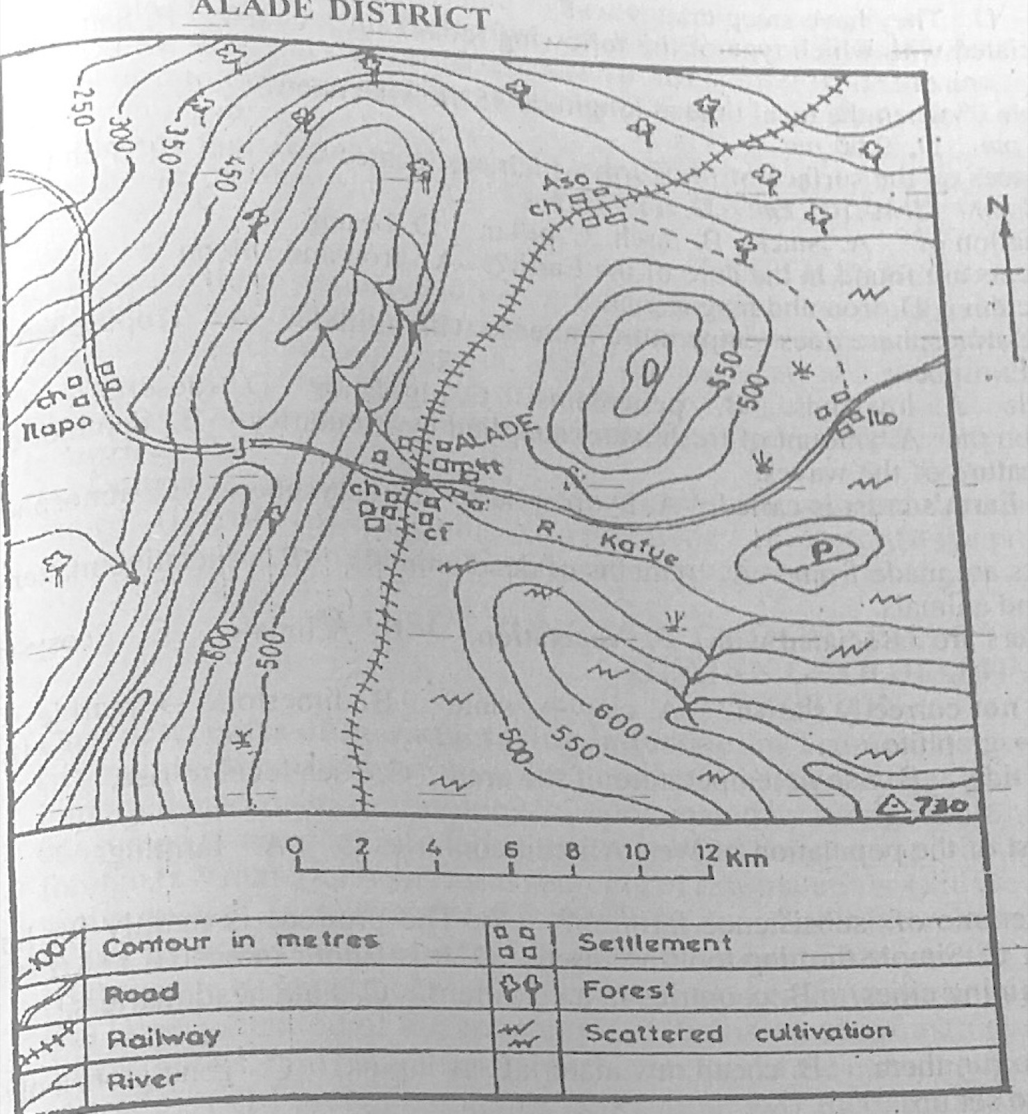
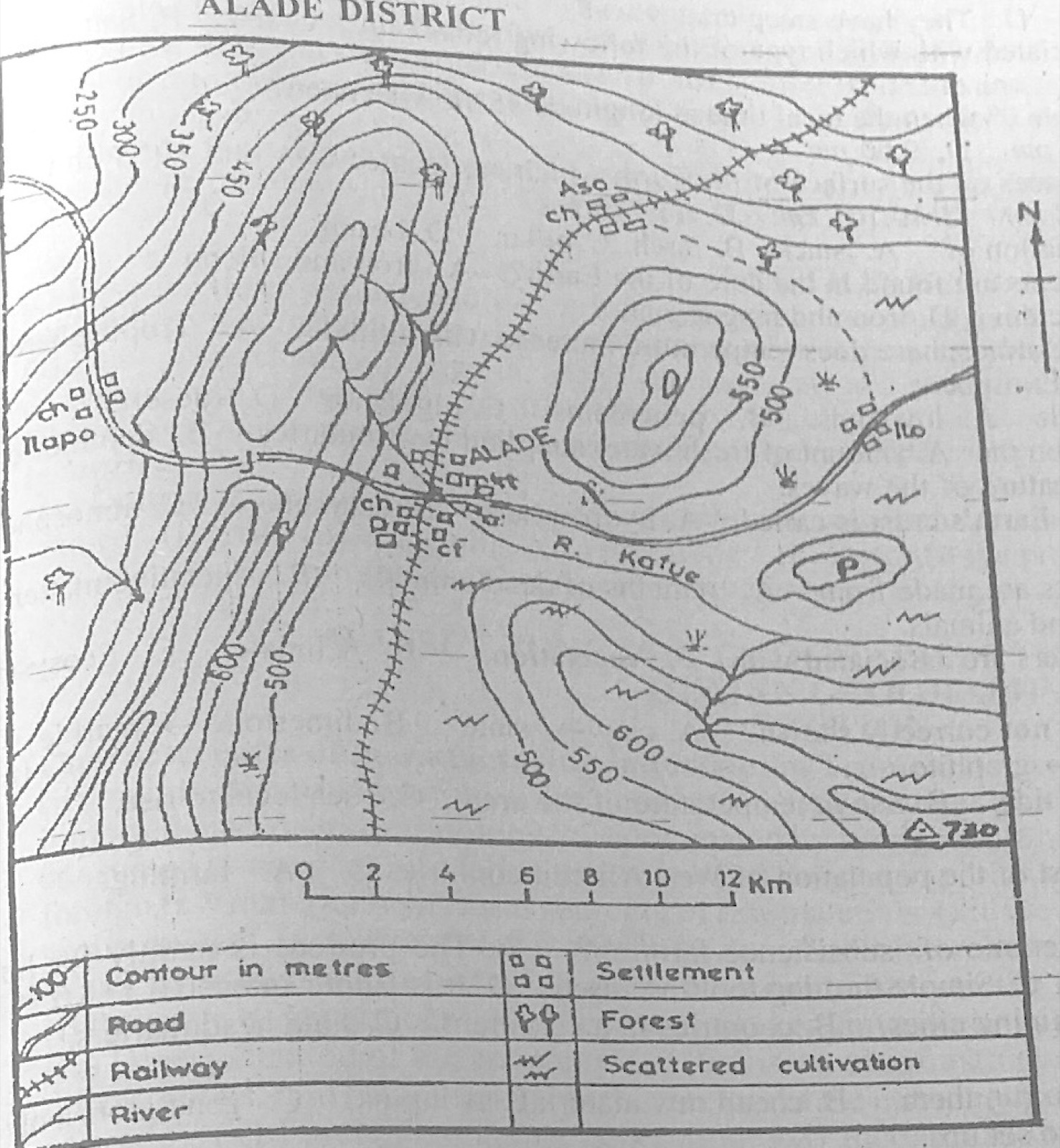
Study the map of ALADE DISTRICT to answer this question. Which area on the map can the trigonometrical station be found?

Diagram for this question
  1. A.North-east
  2. B.South-east
  3. C.North-west
  4. D.South-west
Show the answer and explanation

Answer: B (South-east)

Explanation

The triangle marked 730 is in the south-east corner.

Open this question

Question 4

Map Scale, Distance and Direction

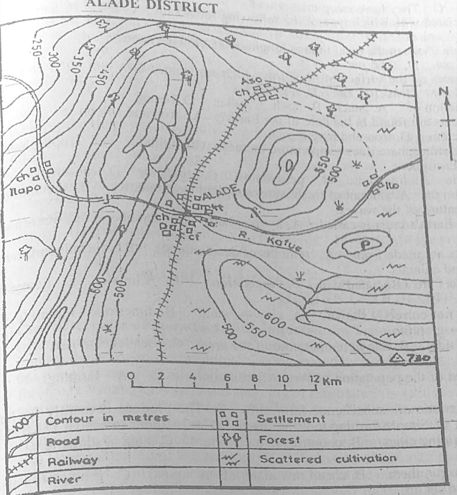
Study the map of ALADE DISTRICT to answer this question. What is the approximate length of the railway line on the map?

Diagram for this question
  1. A.29 km
  2. B.37 km
  3. C.40 km
  4. D.45 km
Show the answer and explanation

Answer: A (29 km)

Explanation

Following the railway from the north-east edge through Aso and ALADE to its southern end and comparing with the linear scale gives about 28 km, closest to 29 km.

Open this question

Question 6

Relief and Map Interpretation

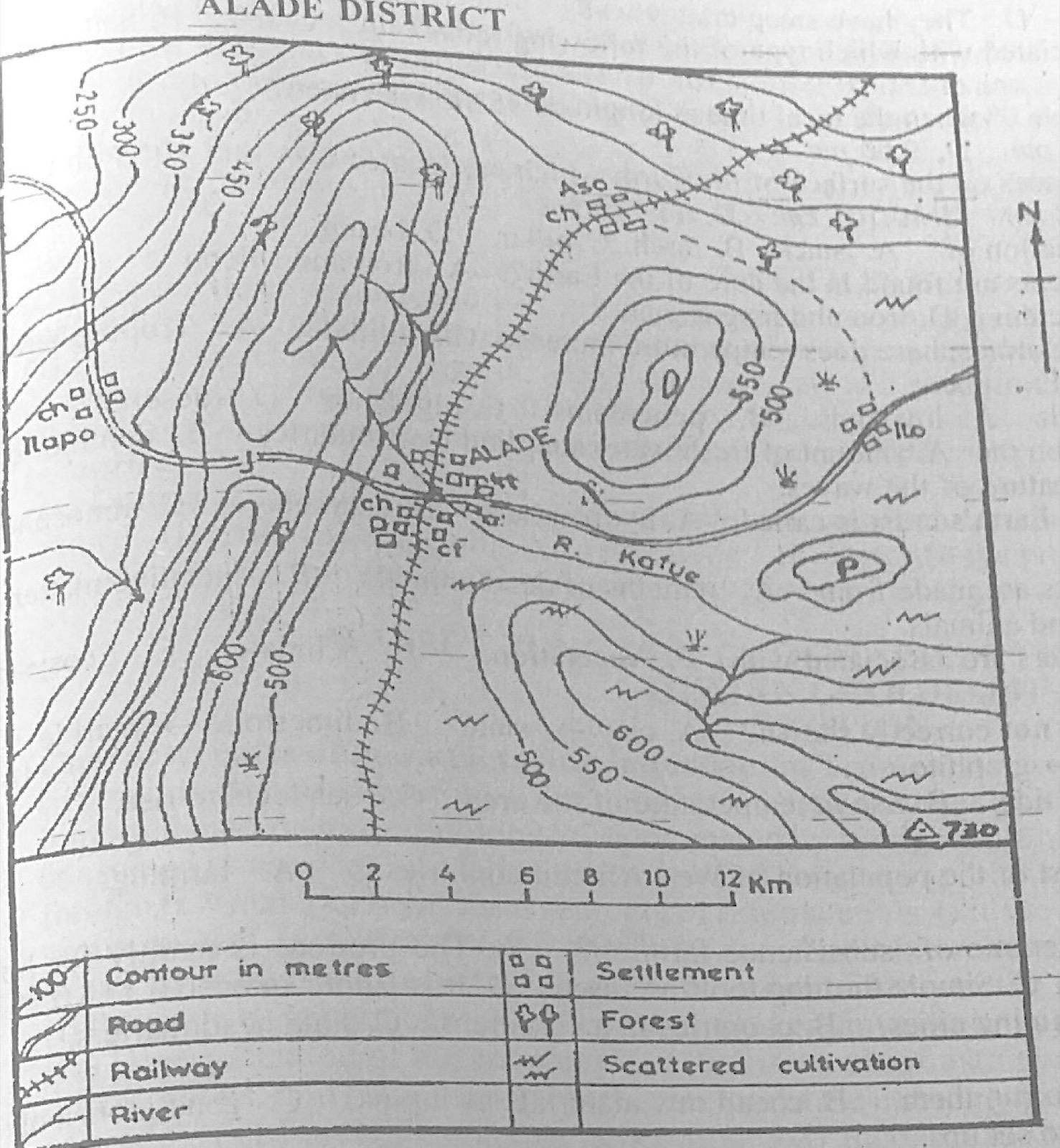
Study the map of ALADE DISTRICT to answer this question. The feature marked P is a

Diagram for this question
  1. A.mountain.
  2. B.spur.
  3. C.knoll.
  4. D.valley.
Show the answer and explanation

Answer: C (knoll.)

Explanation

P is a small, low, rounded hill shown by one or two closed contours: a knoll.

Open this question

Question 7

Relief and Map Interpretation

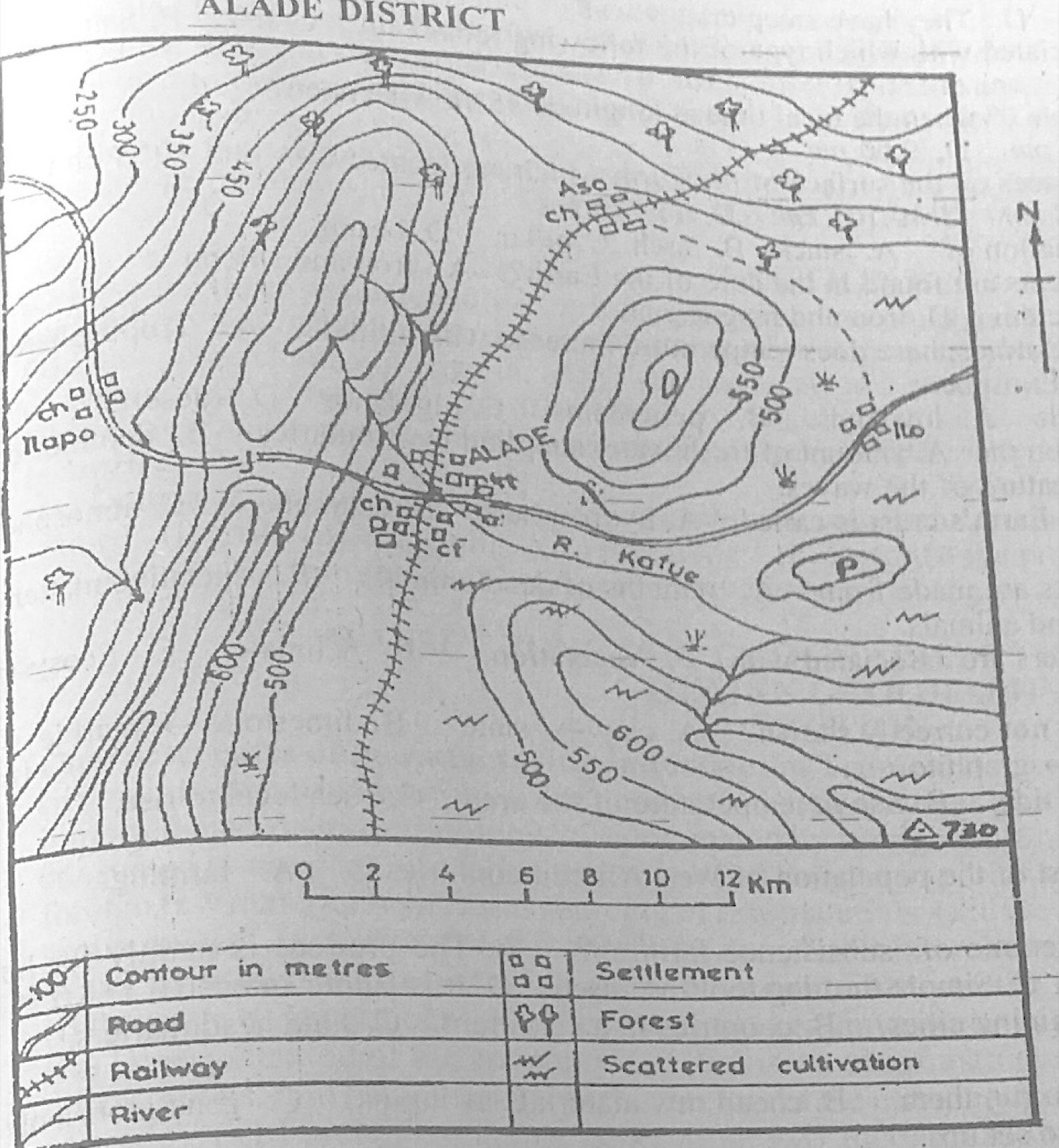
Study the map of ALADE DISTRICT to answer this question. The northern part of the map is suitable for

Diagram for this question
  1. A.mining.
  2. B.trading.
  3. C.lumbering.
  4. D.farming.
Show the answer and explanation

Answer: C (lumbering.)

Explanation

The north is covered by forest symbols, suitable for lumbering.

Open this question

Question 8

Relief and Map Interpretation

Study the map of ALADE DISTRICT to answer this question. What type of settlement is ALADE?

Diagram for this question
  1. A.Nodal
  2. B.Coastal
  3. C.Dry Valley
  4. D.Linear
Show the answer and explanation

Answer: A (Nodal)

Explanation

Roads and the railway meet at ALADE: a nodal settlement.

Open this question

Question 9

Map Scale, Distance and Direction

Study the map of ALADE DISTRICT to answer this question. What is the bearing of the trigonometrical station from Ilo on the map?

Diagram for this question
  1. A.168°
  2. B.178°
  3. C.190°
  4. D.200°
Show the answer and explanation

Answer: B (178°)

Explanation

The trigonometrical station lies almost due south of Ilo, slightly to the east, so the bearing is a little under 180°: about 178°.

Open this question

Question 10

Relief and Map Interpretation

Study the map of ALADE DISTRICT to answer this question. The most important settlement in the area is

Diagram for this question
  1. A.Ilo.
  2. B.Ilapo.
  3. C.Aso.
  4. D.ALADE.
Show the answer and explanation

Answer: D (ALADE.)

Explanation

ALADE is the largest settlement, with a market, churches and the meeting of road and railway.

Open this question

Question 11

Climate

Use the climatic data below to answer this question.
Month: Jan, Feb, Mar, Apr, May, June, July, Aug, Sept, Oct, Nov, Dec
Temperature (°C): 26, 26, 26, 26, 26, 27, 27, 28, 28, 28, 27, 27
Rainfall (mm): 35, 50, 104, 139, 195, 228, 248, 243, 245, 250, 91, 55
The annual range of temperature for the station is

  1. A.1°C.
  2. B.2°C.
  3. C.22°C.
  4. D.28°C.
Show the answer and explanation

Answer: B (2°C.)

Explanation

Highest 28°C − lowest 26°C = 2°C.

Open this question

Question 12

Climate

Use the climatic data below to answer this question.
Month: Jan, Feb, Mar, Apr, May, June, July, Aug, Sept, Oct, Nov, Dec
Temperature (°C): 26, 26, 26, 26, 26, 27, 27, 28, 28, 28, 27, 27
Rainfall (mm): 35, 50, 104, 139, 195, 228, 248, 243, 245, 250, 91, 55
From which climatic region were the data taken?

  1. A.Desert
  2. B.Mediterranean
  3. C.Equatorial
  4. D.Tropical Monsoon
Show the answer and explanation

Answer: C (Equatorial)

Explanation

Temperatures are high and almost constant (range 2°C) and rain falls in every month, as in the equatorial (tropical wet) region.

Open this question

Question 13

Climate

Use the climatic data below to answer this question.
Month: Jan, Feb, Mar, Apr, May, June, July, Aug, Sept, Oct, Nov, Dec
Temperature (°C): 26, 26, 26, 26, 26, 27, 27, 28, 28, 28, 27, 27
Rainfall (mm): 35, 50, 104, 139, 195, 228, 248, 243, 245, 250, 91, 55
Which of the following towns experiences the type of climate represented in the table?

  1. A.Gao (Mali)
  2. B.Cairo (Egypt)
  3. C.Warri (Nigeria)
  4. D.London (England)
Show the answer and explanation

Answer: C (Warri (Nigeria))

Explanation

Warri, in the humid south of Nigeria, has hot wet conditions like these.

Open this question

Question 14

Climate

Use the climatic data below to answer this question.
Month: Jan, Feb, Mar, Apr, May, June, July, Aug, Sept, Oct, Nov, Dec
Temperature (°C): 26, 26, 26, 26, 26, 27, 27, 28, 28, 28, 27, 27
Rainfall (mm): 35, 50, 104, 139, 195, 228, 248, 243, 245, 250, 91, 55
What is the mean temperature from July to December?

  1. A.16.5°C
  2. B.17.2°C
  3. C.27.5°C
  4. D.28.0°C
Show the answer and explanation

Answer: C (27.5°C)

Explanation

(27 + 28 + 28 + 28 + 27 + 27) ÷ 6 = 165 ÷ 6 = 27.5°C.

Open this question

Question 15

Climate

In Koppen's Classification of climates, Cs, refers to

  1. A.Steppe.
  2. B.Mediterranean.
  3. C.Tropical Monsoon.
  4. D.Tropical Continental.
Show the answer and explanation

Answer: B (Mediterranean.)

Explanation

Cs = warm temperate climate with a dry summer: Mediterranean.

Open this question

Question 16

Rivers and River Landforms

Which of the following features is associated with river capture?

  1. A.Delta
  2. B.Meander
  3. C.Levee
  4. D.Wind gap
Show the answer and explanation

Answer: D (Wind gap)

Explanation

River capture leaves a dry wind gap in the beheaded stream's valley.

Open this question

Question 17

Earth Movements and Vulcanicity

Volcanoes that have erupted before and show signs of possible eruption again are said to be

  1. A.weak.
  2. B.extinct.
  3. C.dormant.
  4. D.ongoing.
Show the answer and explanation

Answer: C (dormant.)

Explanation

A dormant volcano is 'sleeping': it has erupted before and may erupt again.

Open this question

Question 18

The Earth and Solar System

In the northern hemisphere, summer solstice is experienced on

  1. A.September 22.
  2. B.June 21.
  3. C.December 22.
  4. D.March 21.
Show the answer and explanation

Answer: B (June 21.)

Explanation

On 21 June the sun is overhead at the Tropic of Cancer.

Open this question

Question 19

The Ecosystem

A community of plants and animals living in harmony within the same physical environment is referred to as

  1. A.environmental interaction.
  2. B.terrestrial biocycle.
  3. C.ecosystem.
  4. D.biosphere.
Show the answer and explanation

Answer: C (ecosystem.)

Explanation

An ecosystem is a community of living things interacting with their environment.

Open this question

Question 20

Weather

Sea breeze is most effective at

  1. A.winter.
  2. B.day time.
  3. C.summer.
  4. D.night time.
Show the answer and explanation

Answer: B (day time.)

Explanation

The land heats faster than the sea by day, so cool air blows from sea to land during the day.

Open this question

Question 21

The Earth and Solar System

The nearest planet to the sun is

  1. A.Jupiter.
  2. B.Saturn.
  3. C.Mercury.
  4. D.Earth.
Show the answer and explanation

Answer: C (Mercury.)

Explanation

Mercury is the first planet from the sun.

Open this question

Question 22

Weather

The type of rain mostly experienced within the tropics is

  1. A.fog.
  2. B.relief.
  3. C.frontal.
  4. D.convectional.
Show the answer and explanation

Answer: D (convectional.)

Explanation

Intense heating makes moist air rise, giving afternoon convectional storms.

Open this question

Question 23

Rivers and River Landforms

A feature commonly found in the youthful stage of a river is

  1. A.Levee.
  2. B.Meander.
  3. C.Ox-bow lake.
  4. D.Interlocking spurs.
Show the answer and explanation

Answer: D (Interlocking spurs.)

Explanation

Interlocking spurs occur in the steep V-shaped valleys of the upper course.

Open this question

Question 24

Wind and Desert Landforms

Which of the following is not a characteristic of Wadis?

  1. A.They are river channels
  2. B.They occur in tropical areas
  3. C.They hold permanent streams
  4. D.They have steep craggy walls
Show the answer and explanation

Answer: C (They hold permanent streams)

Explanation

Wadis are dry desert valleys that carry water only after rare storms.

Open this question

Question 25

Underground Water and Karst

Stalactites and stalagmites are associated with which type of the following rocks?

  1. A.Granite
  2. B.Sandstone
  3. C.Limestone
  4. D.Basalt
Show the answer and explanation

Answer: C (Limestone)

Explanation

They form in limestone caves from dissolved calcium carbonate.

Open this question

Question 26

Latitude, Longitude and Time

What is the time in Accra at Longitude 0° when the local time at longitude 45°W is 12 noon?

  1. A.3.00pm
  2. B.5.00 pm
  3. C.7.00 pm
  4. D.9.00 pm
Show the answer and explanation

Answer: A (3.00pm)

Explanation

45° × 4 min = 3 hours; Accra is east of 45°W, so it is 3 hours ahead: 12 noon + 3 h = 3.00 pm.

Open this question

Question 27

Latitude, Longitude and Time

What is the distance between two places on the surface of the Earth which are located 8 °N and 10 °S on the same longitude?

  1. A.1,011 km
  2. B.1,998 km
  3. C.10,101 km
  4. D.17,770 km
Show the answer and explanation

Answer: B (1,998 km)

Explanation

They are 8 + 10 = 18° apart; 18 × 111 km = 1,998 km.

Open this question

Question 28

Coastal Landforms

Coastal deposition results in the formation of

  1. A.stack.
  2. B.arch.
  3. C.pillar.
  4. D.beach.
Show the answer and explanation

Answer: D (beach.)

Explanation

A beach is built from sand and pebbles deposited by waves; the others are erosion features.

Open this question

Question 29

Structure of the Earth

Which of the following pairs of elements are found in the core of the Earth?

  1. A.Iron and silicon
  2. B.Iron and nickel
  3. C.Iron and calcium
  4. D.Iron and magnesium
Show the answer and explanation

Answer: B (Iron and nickel)

Explanation

The core (NIFE) is made of nickel and iron.

Open this question

Question 31

Weather

Relief rainfall is mostly associated with

  1. A.lowlands.
  2. B.peneplains.
  3. C.highlands.
  4. D.deserts.
Show the answer and explanation

Answer: C (highlands.)

Explanation

Moist air forced up over highlands cools and gives relief rain.

Open this question

Question 33

Structure of the Earth

The envelope of gases surrounding the Earth's crust is called

  1. A.hydrosphere.
  2. B.barysphere.
  3. C.atmosphere.
  4. D.lithosphere.
Show the answer and explanation

Answer: C (atmosphere.)

Explanation

The atmosphere is the layer of air around the earth.

Open this question

Question 34

Rocks

Carbonaceous type of sedimentary rocks are made from

  1. A.remains of dead animals.
  2. B.vegetative matter.
  3. C.molten magma.
  4. D.living plants and animals.
Show the answer and explanation

Answer: B (vegetative matter.)

Explanation

Carbonaceous rocks such as coal and lignite form from plant (vegetative) matter.

Open this question

Question 35

The Ecosystem

Autotrophs, heterotrophs and decomposers are associated with

  1. A.Vegetation.
  2. B.Climate.
  3. C.Ecosystem.
  4. D.Geology.
Show the answer and explanation

Answer: C (Ecosystem.)

Explanation

Producers, consumers and decomposers are the living parts of an ecosystem.

Open this question

Question 36

Rocks

Which of the following pairs of rocks is not correctly shown?

  1. A.clay → slate
  2. B.limestone → marble
  3. C.sandstone → quartzite
  4. D.shale → graphite
Show the answer and explanation

Answer: D (shale → graphite)

Explanation

Graphite comes from coal; shale becomes slate.

Open this question

Question 37

Oceans and Lakes

Cold currents can also cause

  1. A.rise in tide.
  2. B.rise in temperature of the area.
  3. C.sea level to rise.
  4. D.fogs instead of actual rain.
Show the answer and explanation

Answer: D (fogs instead of actual rain.)

Explanation

Warm moist air passing over a cold current is chilled and forms fog, not rain.

Open this question

Question 38

Agriculture, Fishing and Lumbering

The most predominant occupation of most of the population of West African countries is

  1. A.farming.
  2. B.fishing.
  3. C.mining.
  4. D.teaching.
Show the answer and explanation

Answer: A (farming.)

Explanation

Most West Africans earn a living from farming.

Open this question

Question 39

Agriculture, Fishing and Lumbering

Which of the following is not a characteristic of subsistence farming?

  1. A.The produce is mainly for home consumption
  2. B.It is capital intensive
  3. C.Simple farming tools are used
  4. D.It is labour intensive
Show the answer and explanation

Answer: B (It is capital intensive)

Explanation

Subsistence farming uses little capital; it relies on family labour and simple tools.

Open this question

Question 40

Transport, Trade and Tourism

Trans-continental highways link up

  1. A.mining cities.
  2. B.countries in a continent.
  3. C.state headquarters.
  4. D.local settlements.
Show the answer and explanation

Answer: B (countries in a continent.)

Explanation

A trans-continental highway crosses a continent, linking its countries.

Open this question

Question 41

Manufacturing Industry

Heavy industries require

  1. A.mostly coal to run them.
  2. B.cheap raw materials as inputs.
  3. C.generators only as source of electricity.
  4. D.large capital to set up.
Show the answer and explanation

Answer: D (large capital to set up.)

Explanation

Heavy industries need huge investment in plant and machinery.

Open this question

Question 42

Mining and Energy

Which of the following is likely to make petroleum drilling unimportant?

  1. A.Depletion of reserves
  2. B.Adequate capital
  3. C.Adequate skilled labour
  4. D.Good management
Show the answer and explanation

Answer: A (Depletion of reserves)

Explanation

If the reserves run out, drilling is no longer worthwhile.

Open this question

Question 43

Mining and Energy

Which of the following statements most apply for solar energy production in Tropical Africa?

  1. A.Generated without cost
  2. B.Imported from Europe
  3. C.Produced in higher latitudes
  4. D.Cheap and readily accessible
Show the answer and explanation

Answer: D (Cheap and readily accessible)

Explanation

Tropical Africa has abundant sunshine all year, so solar energy there is cheap and readily accessible.

Open this question

Question 44

Settlement

They are headquarters of governments and are usually capital cities. This best describes

  1. A.market towns.
  2. B.administrative towns.
  3. C.educational towns.
  4. D.mining towns.
Show the answer and explanation

Answer: B (administrative towns.)

Explanation

Seats of government are administrative towns.

Open this question

Question 45

Transport, Trade and Tourism

One of the usefulness of import tariff on imported goods is the

  1. A.encouragement of importation.
  2. B.multiplication of foreign goods.
  3. C.protection of infant industries.
  4. D.saving of money.
Show the answer and explanation

Answer: C (protection of infant industries.)

Explanation

Tariffs make imports dearer and protect young local industries.

Open this question

Question 46

Manufacturing Industry

Textile industries are located

  1. A.near the market.
  2. B.where water resource is scarce.
  3. C.in wide plains.
  4. D.near sources of raw materials.
Show the answer and explanation

Answer: A (near the market.)

Explanation

Textiles are mostly market-oriented, sited near large populations that buy cloth.

Open this question

Question 47

Manufacturing Industry

Which of the following factors is unique for the development of the aircraft industry in California?

  1. A.Availability of cheap labour
  2. B.The peaceful political atmosphere
  3. C.The government limited support
  4. D.Clear sky which favours testing of aircrafts
Show the answer and explanation

Answer: D (Clear sky which favours testing of aircrafts)

Explanation

California's clear, dry, sunny skies allow aircraft to be tested all year, a special advantage of the region.

Open this question

Question 48

Settlement

The ranking of settlements into rural and urban is mostly based on

  1. A.location.
  2. B.size.
  3. C.pattern.
  4. D.population.
Show the answer and explanation

Answer: D (population.)

Explanation

Countries classify settlements as urban or rural mainly by the number of people (e.g. 20,000 in Nigeria).

Open this question

Question 49

Agriculture, Fishing and Lumbering

All the following agricultural practices are intensive farming techniques except

  1. A.land rotation.
  2. B.crop rotation.
  3. C.mixed farming.
  4. D.market gardening.
Show the answer and explanation

Answer: A (land rotation.)

Explanation

Land rotation (bush fallowing) uses land extensively, moving to new plots; the others use the same land intensively.

Open this question

Question 50

Population

Natural increase in population means excess of

  1. A.emigration over immigration.
  2. B.immigration over emigration
  3. C.deaths over births.
  4. D.births over deaths.
Show the answer and explanation

Answer: D (births over deaths.)

Explanation

Natural increase = births minus deaths.

Open this question

Theory question 102

Settlement

(a) Outline four ways in which urban settlements differ from one another. (b) Outline three factors that have contributed to the high population density in Japan. (c) State three problems resulting from the high population density in Japan.

Show the model answer
Model answer

(a) Site (physical location: coastal, hilltop, river); situation (relationship with surrounding areas); size (area and population); functions (administrative, industrial, commercial, port); plan and layout (grid, radial, irregular); age and history; level of services and infrastructure.
(b) Advanced industrialisation offering jobs; intensive agriculture (rice) on fertile alluvial plains; limited lowland (mountainous country) so people crowd on plains and coasts; good transport and communication; high standard of living and medical care (long life expectancy); availability of fish from surrounding seas; political stability.
(c) Overcrowding and housing shortage; traffic congestion; pressure on social amenities; high cost of land and food; pollution and environmental degradation; stress-related illness; shortage of farmland, leading to land reclamation.

Explanation

Japan's plains are small, so people crowd onto them.

Open this question

Theory question 104

Agriculture, Fishing and Lumbering

(a) Describe three characteristics of subsistence agriculture in Nigeria. (b) Outline four advantages of subsistence agriculture. (c) Highlight three disadvantages of subsistence agriculture.

Show the model answer
Model answer

(a) Produce mainly for family consumption with little surplus; small farm holdings; simple tools (hoe, cutlass); family labour; little capital; mixed cropping; bush fallowing or shifting cultivation; low yields; little use of fertilisers or improved seeds.
(b) Feeds the family; low cost (little capital needed); uses family labour; mixed cropping spreads risk and protects soil; fallowing restores fertility; uses simple tools easily available; gives some surplus for local markets.
(c) Low output and income; little surplus for export or industry; cannot feed growing towns; heavy labour and drudgery; slow adoption of modern methods; land degradation where fallow periods shorten.

Explanation

Keep advantages and disadvantages separate.

Open this question

Theory question 105

Nigeria: People and Economy

(a) Draw a sketch map of Nigeria. On the map, locate and name one area important for the manufacturing of: (i) cement; (ii) cocoa products; (iii) flour. (b) Highlight three benefits of large-scale manufacturing industries in Nigeria. (c) Outline three advantages which large-scale manufacturing industries have over small-scale manufacturing industries.

Show the model answer
Model answer

(a) Map: cement at Ewekoro or Shagamu (Ogun), Nkalagu (Ebonyi), Obajana (Kogi), Sokoto, Gboko, Calabar; cocoa products at Ibadan, Ondo, Ikeja, Akure, Ile-Ife; flour at Lagos (Apapa), Kano, Calabar, Port Harcourt.
(b) Employment; large output satisfies home demand; foreign exchange through exports or savings on imports; revenue to government; transfer of technology; infrastructure development; growth of towns and allied industries.
(c) Lower unit cost (economies of scale); higher productivity and output; can afford research and modern technology; better welfare facilities for workers; easier access to loans and capital; can absorb risks; better advertising and wider markets.

Explanation

Name a real town for each product.

Open this question

Theory question 106

Nigeria: People and Economy

(a) Draw a sketch map of Nigeria. On the map, show and name one area each where the following minerals are mined: (i) coal; (ii) crude oil; (iii) limestone. (b) Describe the process of mining coal in Nigeria. (c) Identify four problems affecting the mining industry in Nigeria.

Show the model answer
Model answer

(a) Map: coal at Enugu, Okaba (Kogi), Lafia, Gombe; crude oil in the Niger Delta (Oloibiri, Ughelli, Bonny, Port Harcourt area); limestone at Ewekoro/Shagamu, Nkalagu, Sokoto, Calabar, Obajana, Ashaka.
(b) Underground (adit/shaft) mining at Enugu: tunnels (adits) are driven into the hillside along the seam; roofs are supported with props; air is pumped in; coal is cut with picks, drills or explosives; loaded with shovels onto conveyors or tubs and brought to the surface; then sorted and taken by rail or road to users or ports. Open-cast mining (e.g. Okaba): overburden is removed with machines, the exposed seam is broken and loaded into trucks.
(c) Shortage of capital and modern equipment; inadequate skilled labour; poor transport; mining hazards (collapse, flooding, gas); falling demand (coal replaced by oil and gas); illegal mining and smuggling; insecurity and community conflicts; erratic power supply; depletion of reserves; inconsistent government policy.

Explanation

Describe the steps in order.

Open this question

Theory question 302

Statistical Maps and Diagrams

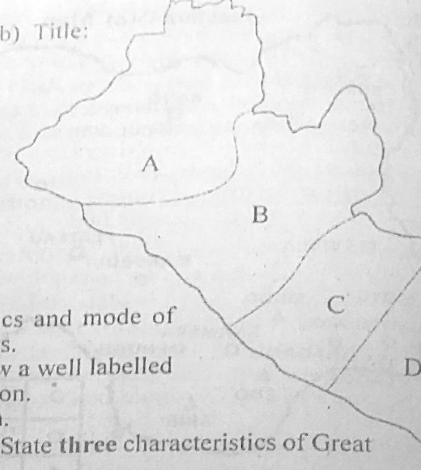
The Population distribution in the regions of Country M in the year 2011 is represented in the table below. Use the data to answer the questions that follow:
Region A: 100,000
Region B: 380,000
Region C: 160,000
Region D: 220,000
(a) Using the map on page 3 and a scale of one dot to represent 20,000 persons, produce a dot map for Country M. (b) On the dot map produced in 2(a), suggest a suitable title. (c) State two advantages of dot maps.

Diagram for this question
Show the model answer
Model answer

(a) Number of dots = population ÷ 20,000: A = 5 dots; B = 19 dots; C = 8 dots; D = 11 dots. Copy the outline of Country M with regions A-D and place the dots, all the same size, evenly within each region; add a key (1 dot = 20,000 persons).
(b) e.g. 'Dot map showing the distribution of population in the regions of Country M in 2011'.
(c) Gives a clear visual impression of distribution and density; easy to understand; actual figures can be worked out by counting dots; easy to construct; shows absolute values; allows easy comparison between regions.

Explanation

Show the dot calculation for each region.

Open this question

Theory question 303

Wind and Desert Landforms

With the aid of annotated diagrams, explain the characteristics and mode of formation of the following features: (a) gorges; (b) seif dunes.

Show the model answer
Model answer

(a) Gorge: characteristics: a deep, narrow river valley with very steep (almost vertical) sides; often has rapids; found in the upper course or where a river crosses hard rock or a plateau. Formation: a river cuts down vertically through resistant rock; a waterfall retreats upstream by undercutting and collapse, leaving a gorge below it; or rapid uplift (rejuvenation) makes the river cut down fast; in dry areas, little weathering of the sides keeps them steep. Examples: Kainji gorge on the Niger, Batoka gorge (Victoria Falls). Diagram: retreating waterfall and gorge.
(b) Seif dune: characteristics: long, narrow, sharp-crested sand ridges lying parallel to the prevailing wind; may be many kilometres long and up to 100 m high; separated by sand-free corridors. Formation: formed where the dominant wind blows steadily in one direction with occasional cross winds; eddies between the ridges sweep the corridors clear and pile sand along the ridges; a barchan may be elongated into a seif when one horn grows. Examples: Sahara (Libya, Egypt). Diagram: parallel ridges with wind arrows.

Explanation

Annotate both diagrams.

Open this question

Theory question 304

Underground Water and Karst

(a)(i) List three landforms found in limestone regions. (ii) Draw a well labelled diagram to show the underground features of a limestone region. (b) Outline three ways by which limestone is beneficial to man.

Show the model answer
Model answer

(a)(i) Swallow holes (sink holes); dolines and uvalas; poljes; limestone pavement (clints and grikes); dry valleys; caves and caverns; stalactites, stalagmites and pillars; gorges; resurgent streams.
(ii) Diagram: cross-section showing a swallow hole leading to an underground stream, a cave/cavern with stalactites hanging from the roof, stalagmites on the floor, a pillar where they join, and a spring (resurgence) at the base where the stream reappears above impermeable rock.
(b) Raw material for cement; building and road stone; flux in iron and steel smelting; lime for agriculture (reducing soil acidity); chemical industries (soda, paper, glass); tourism (caves); aquifers for water.

Explanation

Label every underground feature.

Open this question

Theory question 305

The Earth and Solar System

(a) With the aid of a diagram, explain eclipse of the moon. (b) State three characteristics of Great Circles. (c) Outline three uses of Great Circles.

Show the model answer
Model answer

(a) An eclipse of the moon (lunar eclipse) happens when the earth comes directly between the sun and the moon, so the earth's shadow falls on the moon and blocks the sunlight it reflects; it occurs at full moon; it may be total (moon in the umbra) or partial (moon partly in the penumbra). Diagram: sun - earth - moon in a straight line with the earth's shadow cone covering the moon.
(b) A great circle divides the earth into two equal halves (hemispheres); its plane passes through the centre of the earth; it is the largest circle that can be drawn on the globe; the Equator is the only latitude that is a great circle; any pair of opposite longitudes forms one; there can be an infinite number of them.
(c) The shortest distance between two places lies along a great circle, so they are used for planning air routes and sea routes; navigation; saving fuel and time; used in calculating distances; telecommunication routes.

Explanation

Draw the shadow cone clearly.

Open this question

Theory question 307

Rivers and River Landforms

With appropriate diagrams, outline three conditions under which the following features can be formed: (a) river capture; (b) waterfall.

Show the model answer
Model answer

(a) River capture: one river must have greater erosive power (steeper gradient, more water) than its neighbour; the stronger river erodes headward (back towards its source) through soft rock; the two rivers must be close together, separated by a low watershed; the capturing river must flow at a lower level; result: elbow of capture, misfit stream and wind gap. Diagram: before and after capture.
(b) Waterfall: a band of hard rock lying across the river over soft rock, which is eroded faster (differential erosion); a fault scarp across the river course; a plateau edge or escarpment; a hanging valley left by glaciation; rejuvenation (knick point); a lava flow damming the valley; examples: Kwa Falls, Victoria Falls, Owu Falls. Diagram: hard rock over soft rock with plunge pool.

Explanation

Draw before and after diagrams for capture.

Open this question

Theory question 308

Environmental Hazards and Conservation

Write a geographical account of flooding in urban areas under the following headings: (a) four causes; (b) three effects. (c) four measures that can be used to control the flooding.

Show the model answer
Model answer

(a) Heavy and prolonged rainfall; blocked drains from dumping refuse; inadequate or poorly designed drainage; building on flood plains and waterways; paved surfaces that stop infiltration (more run-off); overflow of rivers and dams; low-lying coastal location and sea surges; deforestation and lack of planning.
(b) Loss of lives; destruction of houses, roads and property; displacement of people; spread of water-borne diseases (cholera); disruption of traffic and business; pollution of water; economic losses.
(c) Build and maintain good drainage and clear blocked drains; ban dumping of refuse in drains; enforce town planning and stop building on waterways and flood plains; dredging and channelisation of rivers; build dams, levees and embankments; afforestation and green spaces; flood early-warning systems; public enlightenment.
Explanation

Four, three and four points as asked.

Open this question