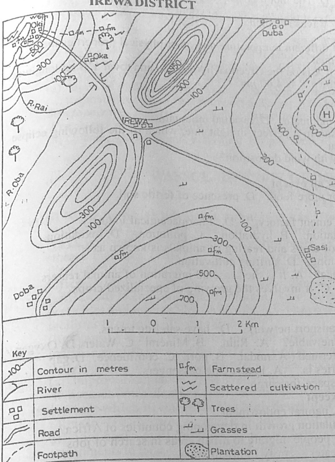
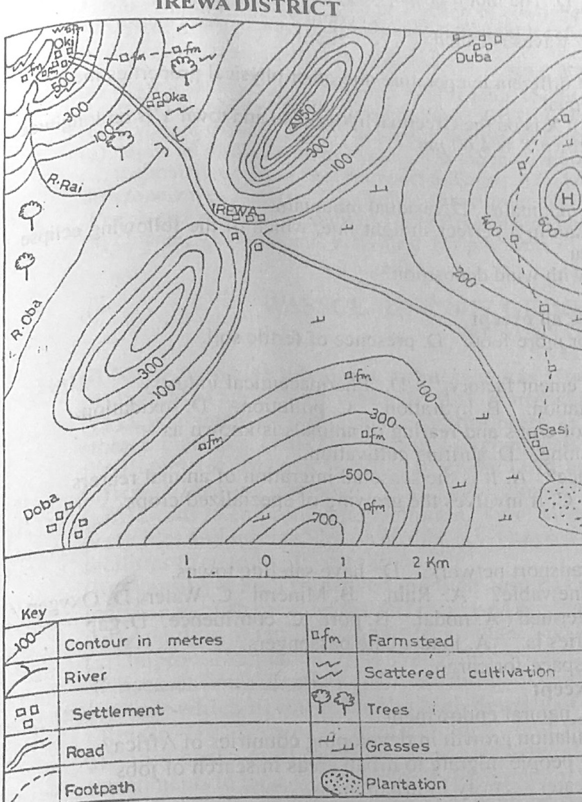
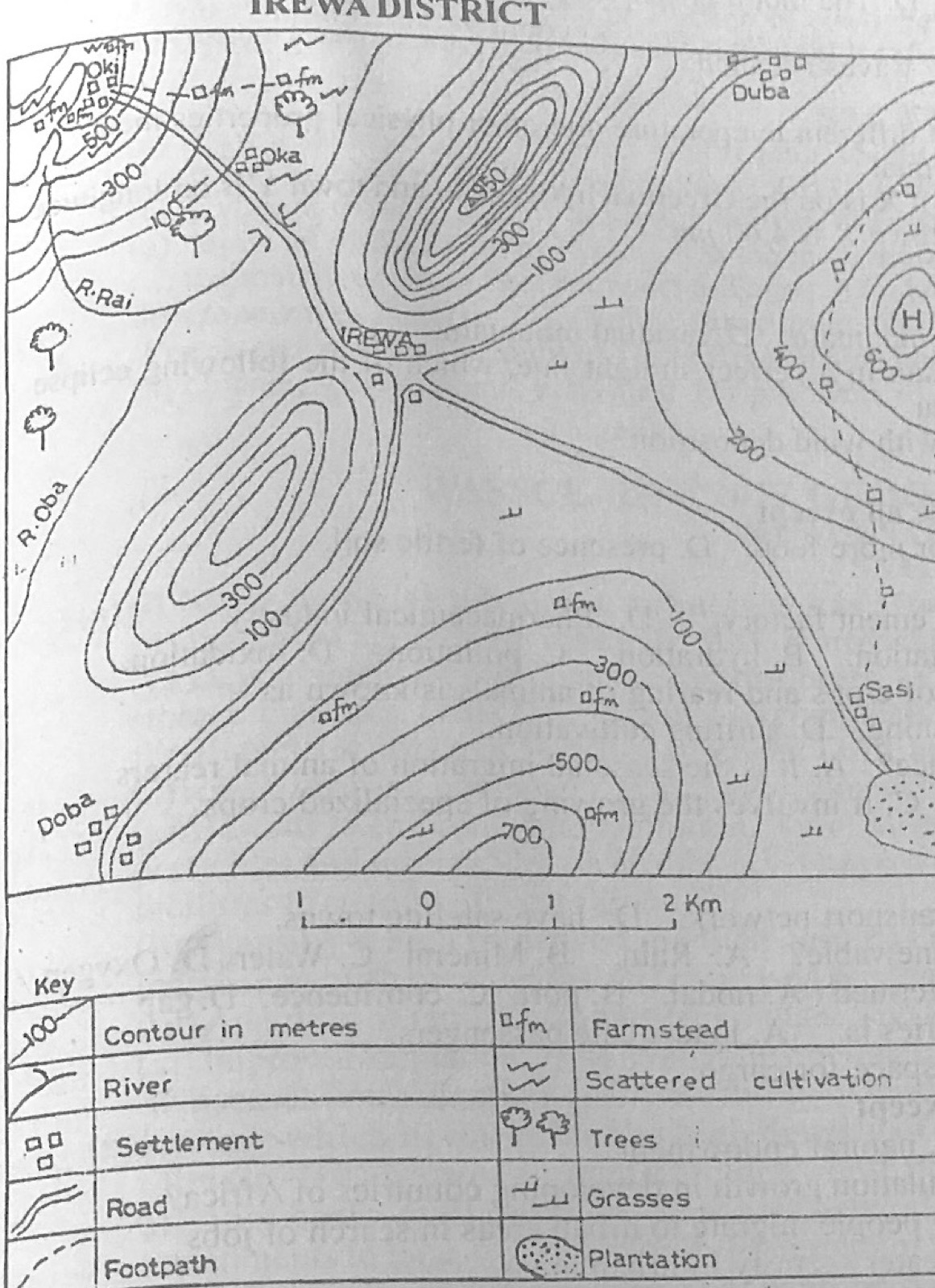
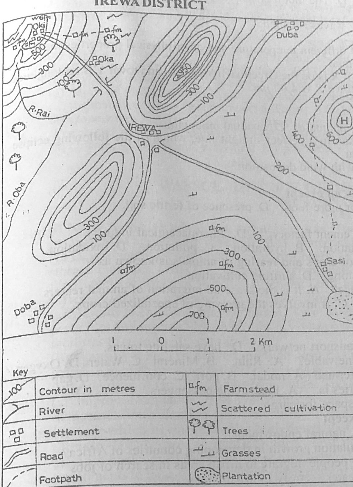
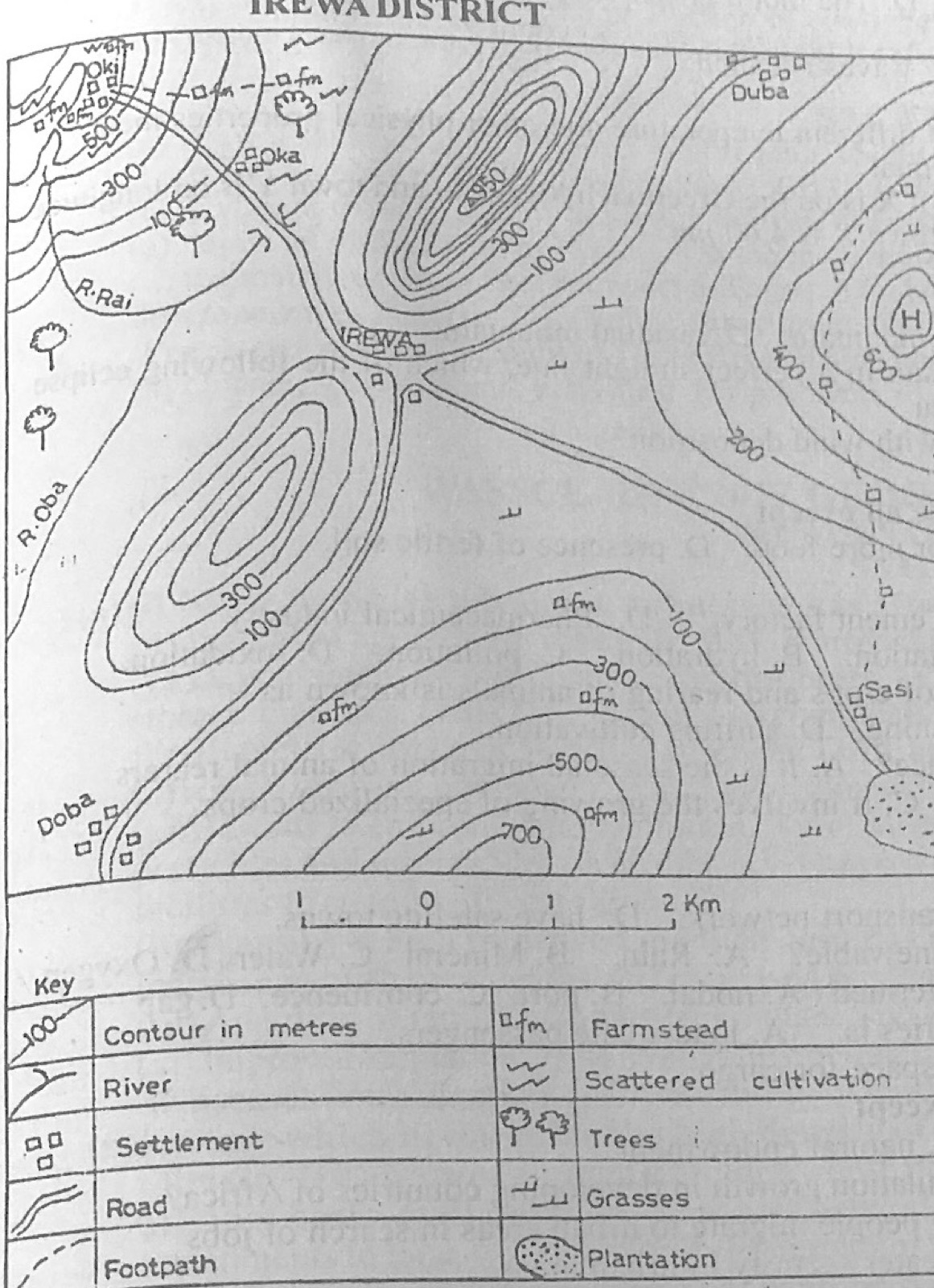
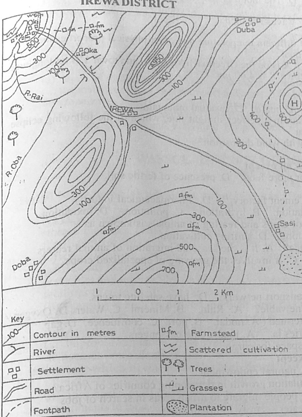
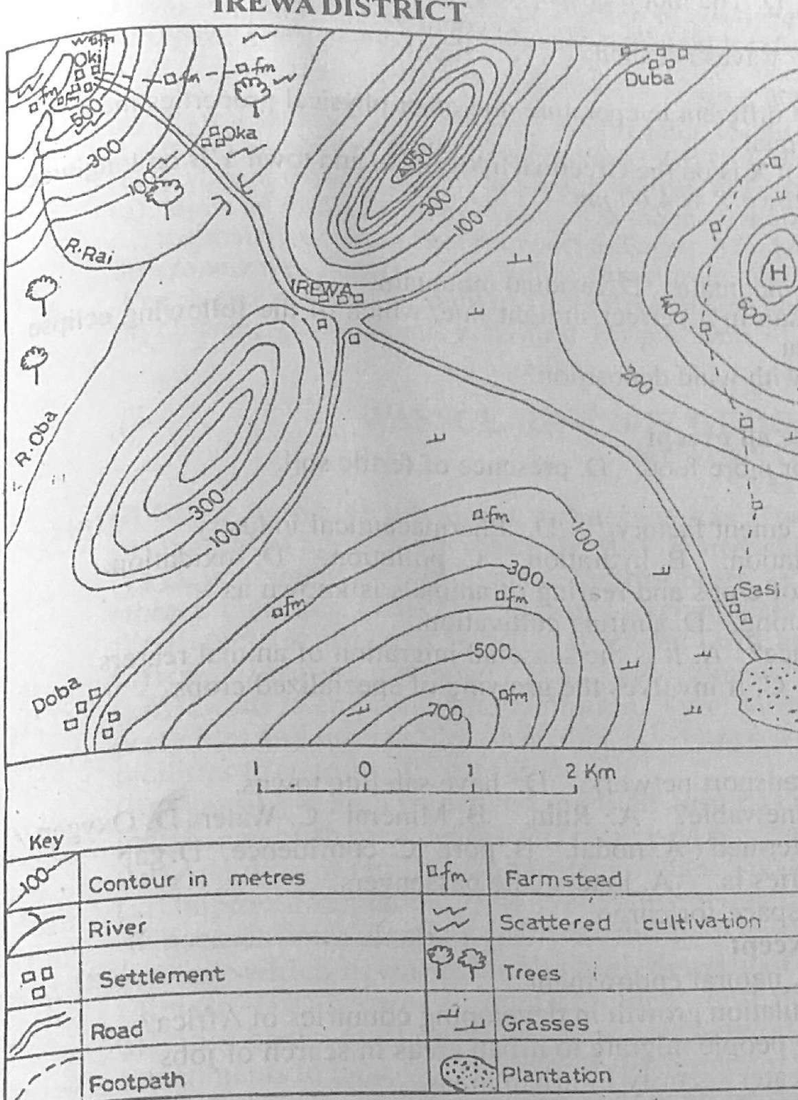
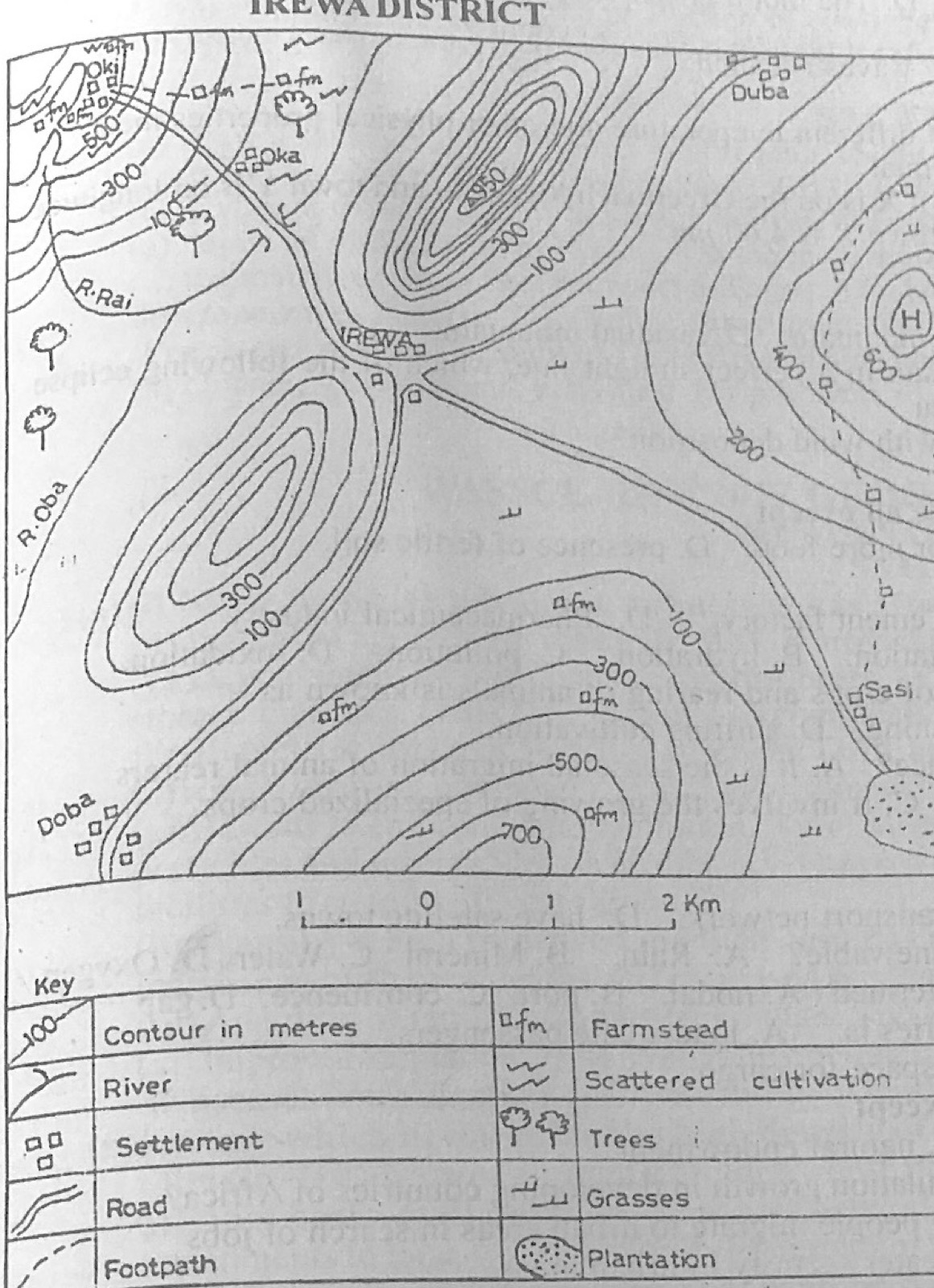
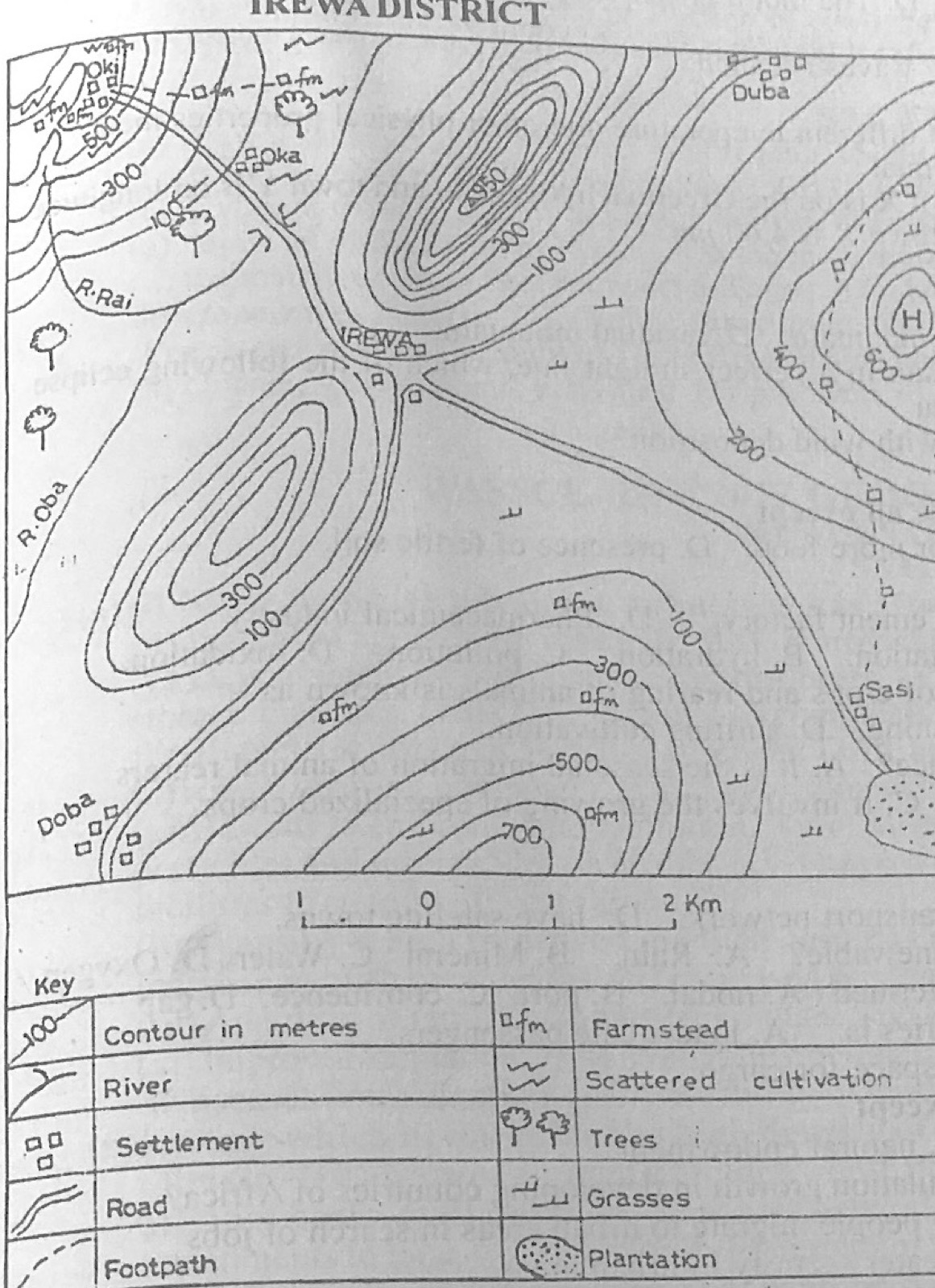
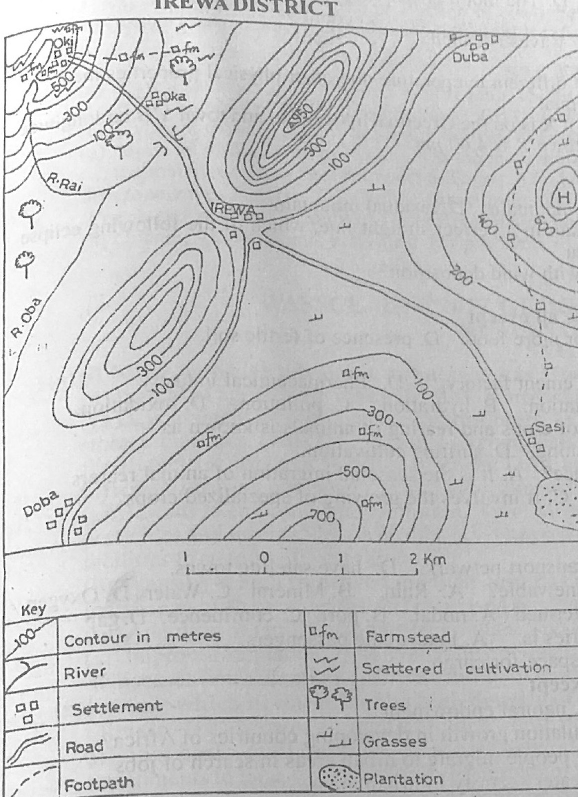
Study the map of IREWA DISTRICT to answer this question. The most probable reason for the construction of the road from IREWA through Sasi to the plantation is
A.because a large percentage of the population lives in Sasi.
B.to provide a means of transporting fish from Sasi to IREWA.
C.to carry the farmers from Sasi to IREWA.
D.to evacuate farm products from the plantation to the market at IREWA.
Show the answer and explanation
Answer: D (to evacuate farm products from the plantation to the market at IREWA.)
Explanation
The road ends at the plantation, so it was built to carry plantation produce to IREWA.
The temperature at the foot of a mountain is 20°C. If the mountain is 6,000 metres above sea level, what will be the approximate temperature at the top of the mountain?
Which of the following processes is associated with the ejection of magma and other related materials from deep below the Earth onto the Earth's surface?
A.Folding
B.Sedimentation
C.Metamorphism
D.Vulcanicity
Show the answer and explanation
Answer: D (Vulcanicity)
Explanation
Vulcanicity covers all movement of magma towards and onto the surface.
(a) State three functions each of the following settlements: (i) urban; (ii) rural. (b) Outline four areas of interdependence between rural and urban centres.
Show the model answer
Model answer
(a)(i) Urban: administrative; commercial and banking; industrial; educational (universities); health care (hospitals); transport and port; residential; religious; tourist/recreational; cultural. (ii) Rural: farming/food production; lumbering; fishing; mining; hunting; local crafts; residential; supply of raw materials; custodians of culture and tradition. (b) Rural areas supply food and raw materials to towns; towns supply manufactured goods to rural areas; rural people supply labour to towns; towns provide markets for rural produce; towns provide higher education, hospitals and banking; towns supply farm inputs (fertilisers, tools) and new ideas; townspeople visit rural areas for recreation and tourism; urban migrants send money home (remittances).
(a) Explain five reasons why the production of consumer goods is common in developing countries. (b) Outline five factors which influence industrial locations.
Show the model answer
Model answer
(a) Large local market for everyday goods such as food, drinks, soap, textiles; little capital is needed compared with heavy industries; simple technology that local workers can handle; local raw materials (agricultural produce) are available; import-substitution policies of governments; quick returns on investment; low level of technology and skilled manpower for heavy industries; shortage of power for heavy industries; foreign firms set up assembly and packaging plants. (b) Raw materials; market; power; labour; capital; transport; water supply; government policy; land; political stability; industrial inertia; security.
(a) Draw a sketch map of Nigeria. On the map, locate and name: (i) Owerri, Ibadan and Birnin Kebbi; (ii) Cross River and Fadama plains of River Sokoto. (b) Outline four factors that encourage tourism in Nigeria. (c) Highlight three problems hindering tourism in Nigeria.
Show the model answer
Model answer
(a) Map: Owerri in the south-east (Imo State); Ibadan in the south-west (Oyo State); Birnin Kebbi in the north-west (Kebbi State) on the Sokoto-Rima valley; Cross River flowing from Cameroon through the south-east to the sea near Calabar; Fadama plains along River Sokoto/Rima in the north-west. (b) Attractive natural scenery (Obudu Ranch, Yankari, Olumo Rock, waterfalls such as Erin Ijesha); rich culture and festivals (Argungu, Osun-Osogbo, Durbar, Calabar carnival); historical sites (Badagry, Sukur); beaches; good climate; hotels and transport facilities; government support (NTDC). (c) Insecurity (kidnapping, terrorism); poor roads and infrastructure; poor publicity; high cost of hotels and services; poor maintenance of sites; epileptic power and water supply; poor funding; negative international image.
(a) Draw an outline map of Nigeria. On the map, mark and name: (i) the railway line from Ibadan to Kano; (ii) the main road from Port Harcourt to Lagos. (b) Highlight four contributions of transportation to the economic development of Nigeria. (c) Outline three problems limiting rail transportation in Nigeria.
Show the model answer
Model answer
(a) Map: western railway from Ibadan through Oshogbo, Ilorin, Jebba, Minna, Kaduna, Zaria to Kano; main road from Port Harcourt through Owerri/Onitsha (or Aba) to Benin City, Ore, Ijebu-Ode/Shagamu and Lagos. (b) Movement of raw materials to factories and goods to markets; movement of people (labour mobility); employment; promotes trade and commerce; opens up rural areas; national integration; earns revenue; supports tourism; growth of towns along routes. (c) Old, single narrow-gauge track; old and broken-down coaches and locomotives; poor maintenance and management; slow speed and poor time schedules; competition from road transport; inadequate funding; derailments; vandalism and theft of rails; limited coverage.
Write a geographical account of Cross River plains under the following headings: (a) climate; (b) economic activities; (c) problems of development.
Show the model answer
Model answer
(a) Tropical wet (sub-equatorial) climate; heavy rainfall over 2,500-3,000 mm, falling most of the year; double maxima in places; high temperatures 24-30°C with small annual range (2-3°C); high relative humidity (over 80%); south-west winds dominant; cloudy skies and convectional thunderstorms. (b) Farming of food crops (yam, cassava, rice) and cash crops (oil palm, cocoa, rubber); fishing in the river and estuary; lumbering in the rain forest; trading (Calabar port); tourism (Obudu Cattle Ranch, Calabar carnival, Cross River National Park); limestone mining and cement (Calabar); local crafts. (c) Flooding and poor drainage; poor transport network; soil erosion and leaching; pests and diseases; inadequate infrastructure and amenities; sparse population in parts; dense forest difficult to clear; land disputes and youth restiveness; inadequate capital.
(a) State the difference between erosion and mass movement. (b) List four agents responsible for modifying landforms. (c) Outline three factors that influence mass movement.
Show the model answer
Model answer
(a) Erosion is the wearing away and removal of rock materials by moving agents (running water, wind, ice, waves), whereas mass movement is the downslope movement of weathered material under the direct influence of gravity, without a transporting agent. (b) Running water (rivers); wind; moving ice (glaciers); waves and sea currents; underground water; man; animals. (c) Gradient (steepness) of slope; amount of water/rainfall lubricating the material; nature and structure of the rocks (loose, jointed, clay); vegetation cover; earthquakes and volcanic activity; human activities (quarrying, road cutting, deforestation); gravity.
(a) List three characteristics of metamorphic rocks. (b) Describe three modes of formation of metamorphic rocks. (c) Outline three economic benefits of rocks.
Show the model answer
Model answer
(a) Formed by alteration of other rocks; hard and compact; crystalline; often banded or foliated; resistant to erosion; contain no fossils (usually); examples: marble, quartzite, slate, gneiss, schist. (b) Thermal (contact) metamorphism: rocks are changed by great heat from magma intrusions, e.g. limestone to marble, sandstone to quartzite; dynamic (pressure) metamorphism: great pressure from earth movements changes rocks, e.g. shale to slate; regional (thermo-dynamic) metamorphism: heat and pressure together over large areas, e.g. granite to gneiss; also chemical (metasomatism) when hot fluids change composition. (c) Building and road materials (granite, marble, sandstone); minerals and ores (tin, gold, coal); raw materials for industries (limestone for cement, clay for pottery); soils form from weathered rocks; aquifers store groundwater; tourism (scenery, caves); fuels (coal, oil in sedimentary rocks).
Explanation
Give a before-and-after rock example for each mode.
(a) With the aid of annotated diagrams, describe the characteristics of the various stages of a river course. (b) List three ways by which rivers are beneficial.
Show the model answer
Model answer
(a) Upper (youthful) course: steep gradient; fast flow; vertical erosion; narrow V-shaped valley; interlocking spurs, waterfalls, rapids, potholes, gorges; small volume. Middle (mature) course: gentler gradient; lateral erosion widens valley; larger volume; meanders begin; river cliffs and slip-off slopes; small floodplain. Lower (old) course: very gentle gradient; slow flow; deposition dominant; wide floodplain; large meanders, ox-bow lakes, levees, braided channels; delta or estuary at the mouth. Annotated diagrams: long profile and a cross-section for each stage. (b) Water supply for domestic use and industries; irrigation; fishing; transport; HEP; fertile alluvial soils; tourism and recreation; sand and gravel for building; boundaries.
(a) Draw an outline of the Earth and show the following: (i) Equator; (ii) tropic of Cancer; (iii) Antarctic Circle. (b) Describe three characteristics of lines of longitude. (c) A football match is scheduled for 5.45 pm local time on Saturday in Onitsha, Nigeria (longitude 7°E). Calculate the local time football fans in Mambola, Sierra Leone (longitude 13°W) can tune their radio sets for the commentary.
Show the model answer
Model answer
(a) Circle for the earth with the Equator (0°) across the middle; Tropic of Cancer at 23½°N; Antarctic Circle at 66½°S, all labelled. (b) They run north-south and meet at the poles; they are semicircles of equal length (half great circles); they are farthest apart at the Equator and converge towards the poles; measured in degrees east or west of the Prime (Greenwich) Meridian, 0° to 180°; used to calculate local time (15° = 1 hour); places on the same longitude have the same local time. (c) Longitude difference = 7° + 13° = 20°; time difference = 20 × 4 minutes = 80 minutes = 1 hour 20 minutes; Mambola is west, so behind: 5.45 pm − 1 h 20 min = 4.25 pm on Saturday.
(a) List five sources of water pollution. (b) Highlight five measures that can be taken to control water pollution.
Show the model answer
Model answer
(a) Industrial effluents; oil spills; sewage and human waste; refuse dumped into rivers and drains; fertilisers and pesticides washed from farms; mining wastes; hot water from power stations (thermal pollution); dead animals; acid rain. (b) Treat industrial waste and sewage before discharge; laws and penalties against polluters; proper refuse disposal and recycling; control of oil spills and pipeline vandalism; controlled use of fertilisers and pesticides; public education; regular monitoring of water quality; provision of toilets and drainage.
(a) With the aid of diagrams, explain how the following factors affect the temperature of a place: (i) latitude; (ii) aspect and slope.
Show the model answer
Model answer
(i) Latitude: near the Equator the sun's rays are vertical, concentrated on a small area and pass through less atmosphere, so temperatures are high; towards the poles the rays are oblique, spread over a larger area and pass through more atmosphere, so temperatures are low; temperature therefore decreases from the Equator to the poles. Diagram: globe with vertical and slanting rays. (ii) Aspect and slope: slopes facing the sun (south-facing in the Northern Hemisphere, north-facing in the Southern) receive direct rays and are warmer than slopes facing away; steep slopes facing the sun receive rays more directly than gentle ones; shaded slopes are cooler and may keep snow longer; this affects settlement and farming (e.g. vineyards on sunny slopes in the Alps). Diagram: valley with sunny (adret) and shady (ubac) slopes.