WAEC Geography 2015 past questions and answers

60 questions. Try each one, then open the answer to check yourself and read the explanation.

Question 1

Map Scale, Distance and Direction

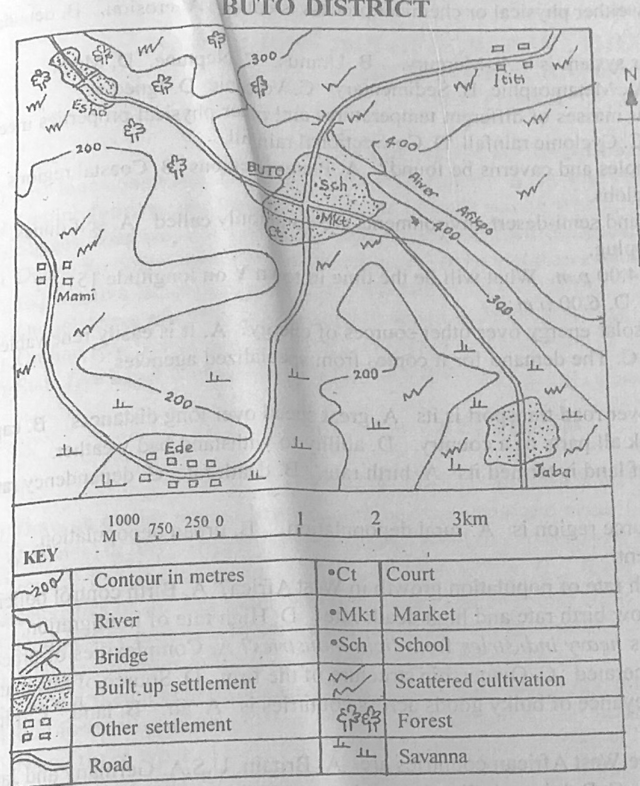
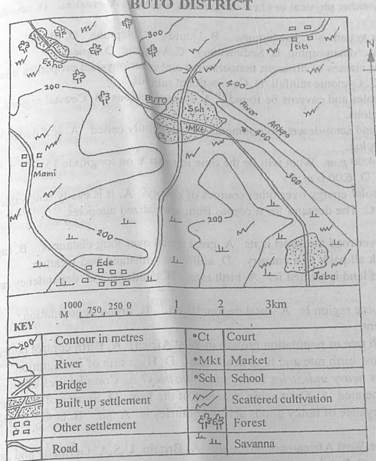
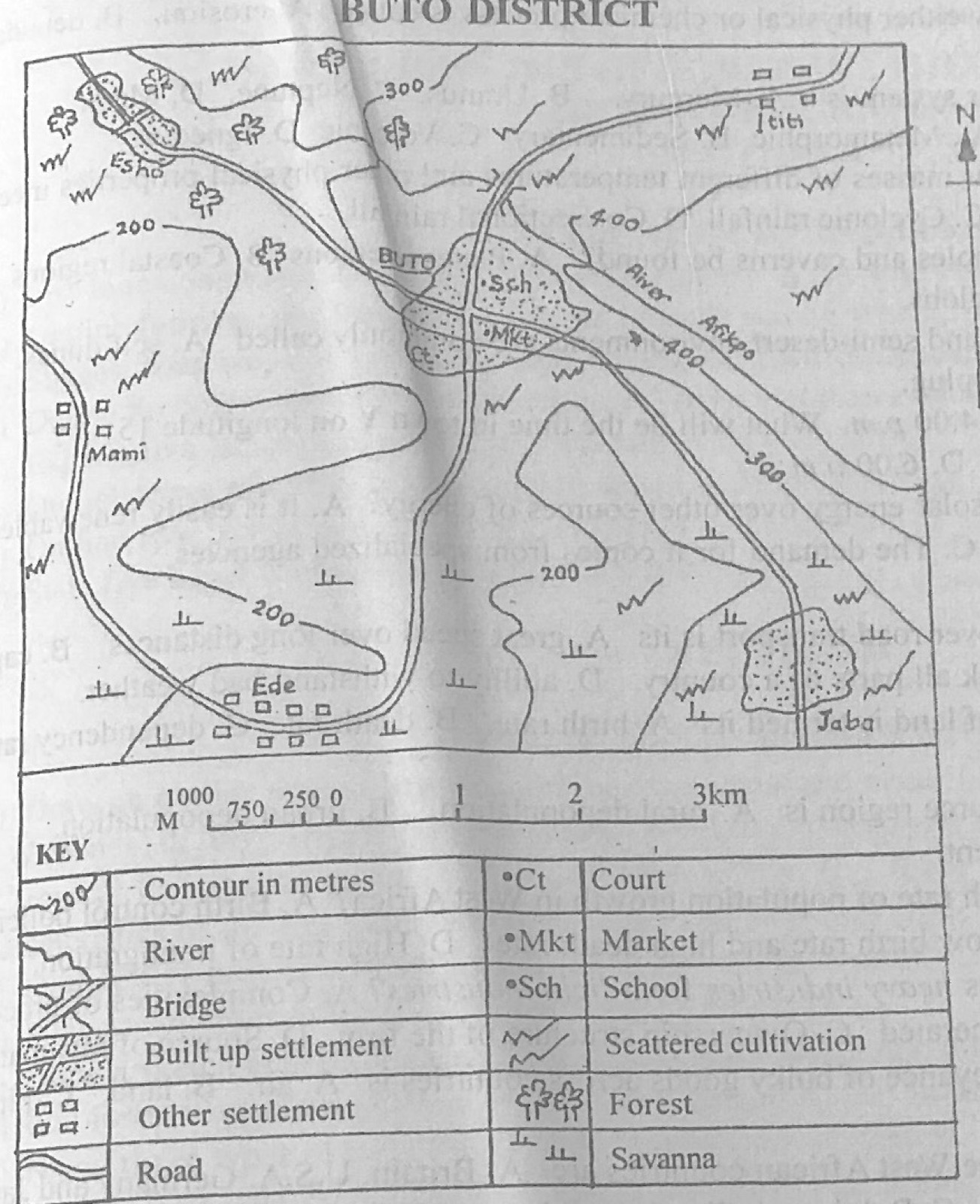
Study the map of BUTO DISTRICT to answer this question. What is the scale of the map in statement form?

Diagram for this question
  1. A.One centimetre on the map represents half a kilometre on the ground
  2. B.One centimetre on the map represents one and half kilometres on the ground
  3. C.One centimetre on the map represents two kilometres on the ground
  4. D.One centimetre on the map represents four kilometres on the ground
Show the answer and explanation

Answer: A (One centimetre on the map represents half a kilometre on the ground)

Explanation

The linear scale shows 1 km as 2 cm on the original map (1:50,000), so 1 cm represents half a kilometre.

Open this question

Question 2

Map Scale, Distance and Direction

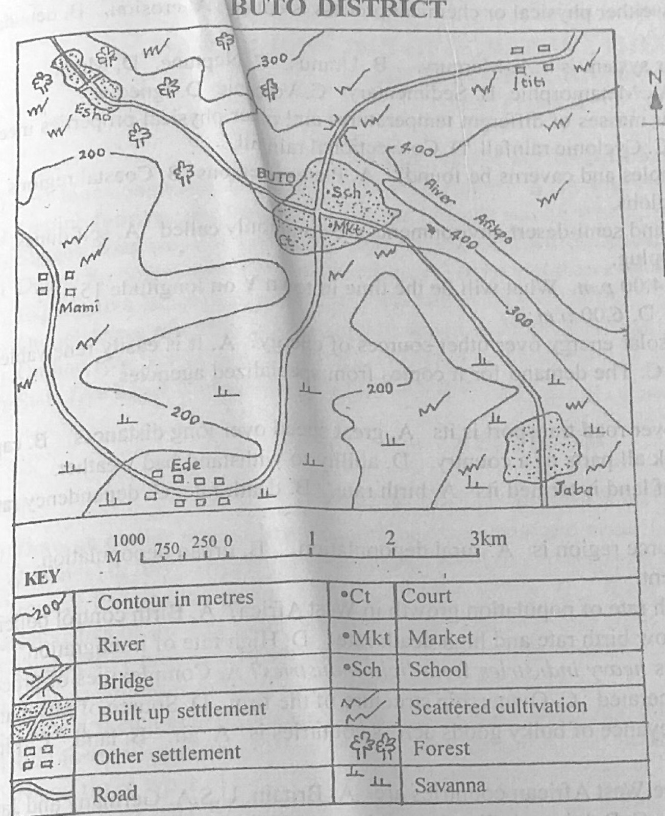
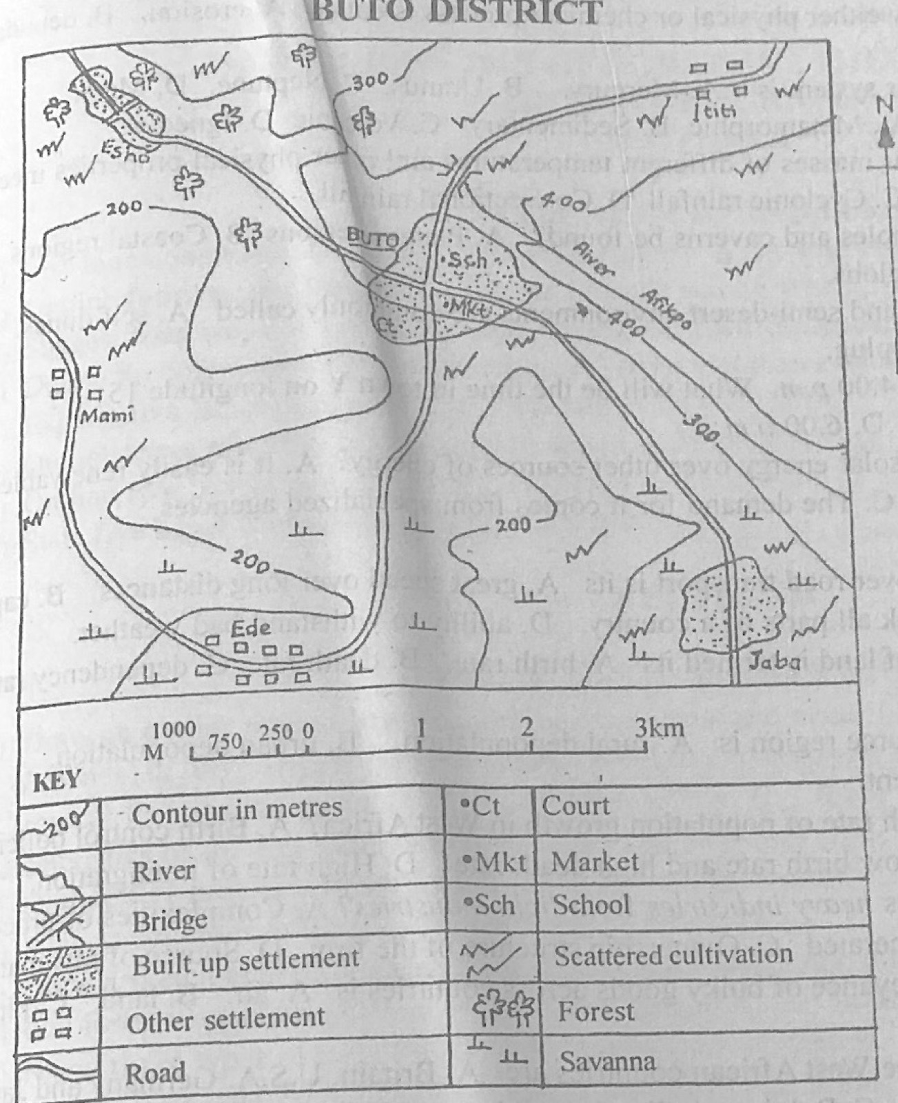
Study the map of BUTO DISTRICT to answer this question. What is the approximate distance as the crow flies from Mami to Esho?

Diagram for this question
  1. A.12.0 km
  2. B.9.0 km
  3. C.3.0 km
  4. D.1.5 km
Show the answer and explanation

Answer: C (3.0 km)

Explanation

Measured in a straight line and compared with the linear scale, Mami to Esho is about 3 km.

Open this question

Question 3

Relief and Map Interpretation

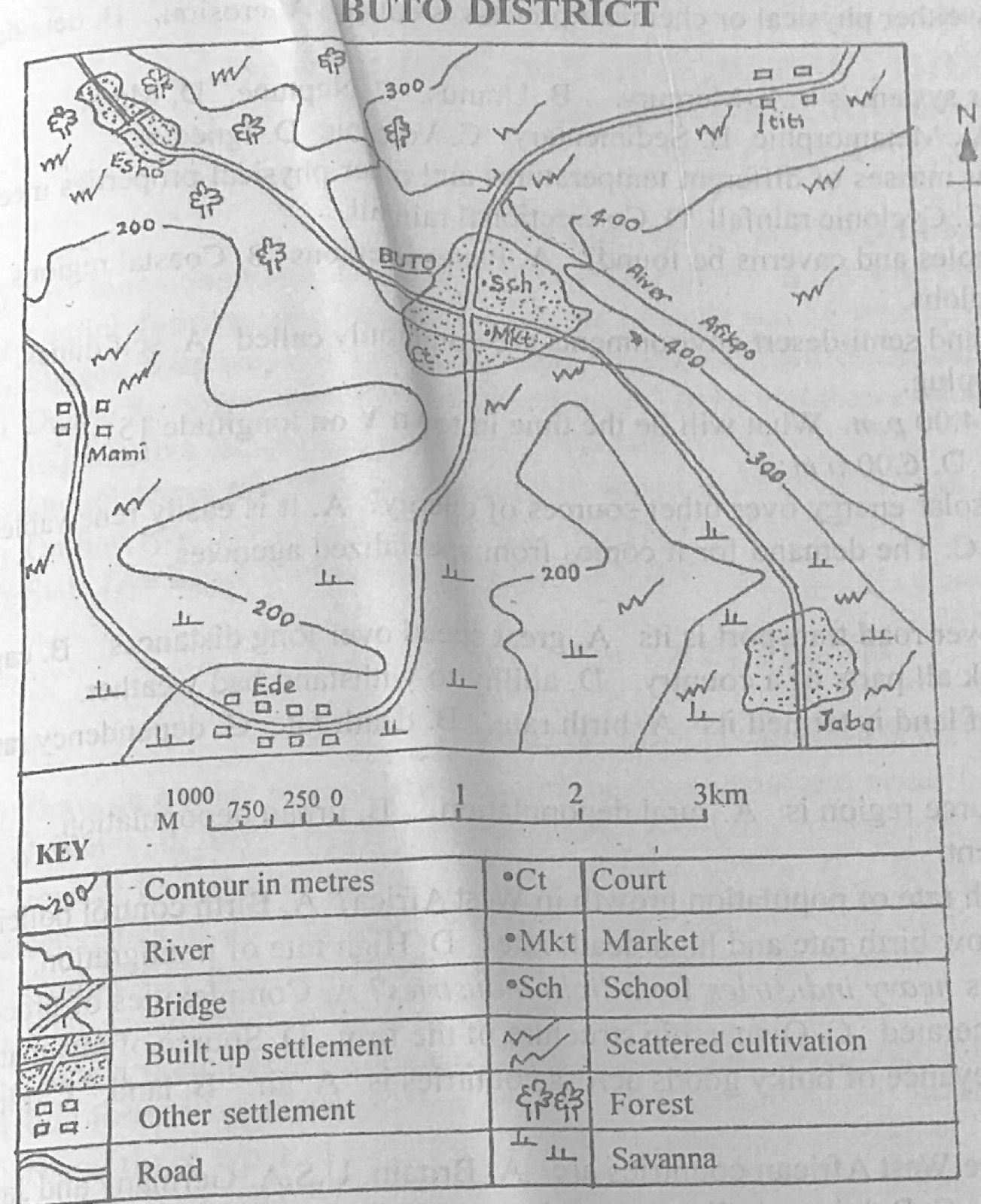
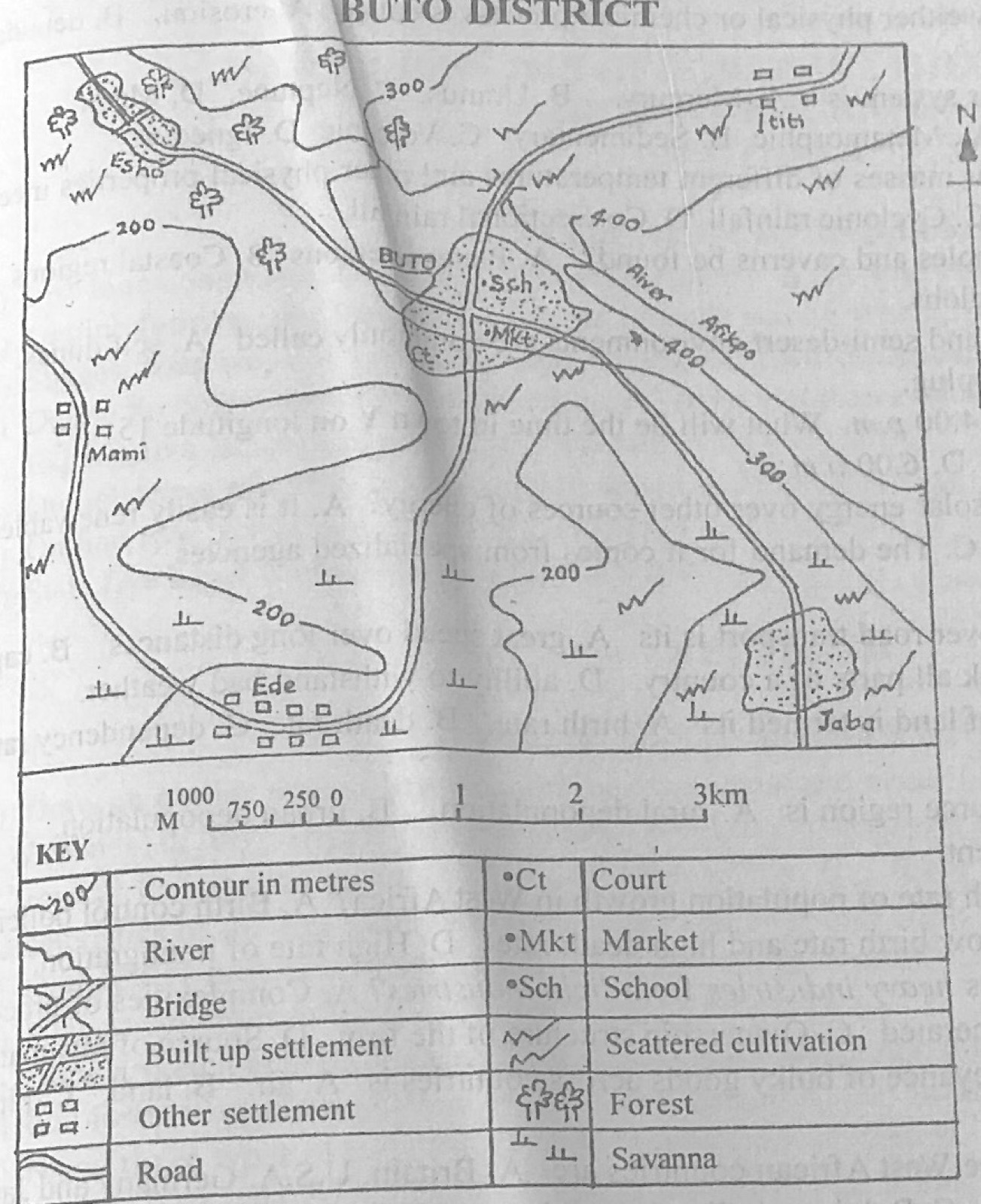
Study the map of BUTO DISTRICT to answer this question. Which of the following settlements performs administrative function?

Diagram for this question
  1. A.Jaba
  2. B.Ede
  3. C.BUTO
  4. D.Ititi
Show the answer and explanation

Answer: C (BUTO)

Explanation

BUTO has a court (Ct), a sign of administrative function.

Open this question

Question 4

Relief and Map Interpretation

Study the map of BUTO DISTRICT to answer this question. In which part of the mapped area is lumbering a likely economic activity?

Diagram for this question
  1. A.Northeast
  2. B.Southeast
  3. C.Southwest
  4. D.Northwest
Show the answer and explanation

Answer: D (Northwest)

Explanation

The forest symbols are in the north-west, around Esho.

Open this question

Question 6

Relief and Map Interpretation

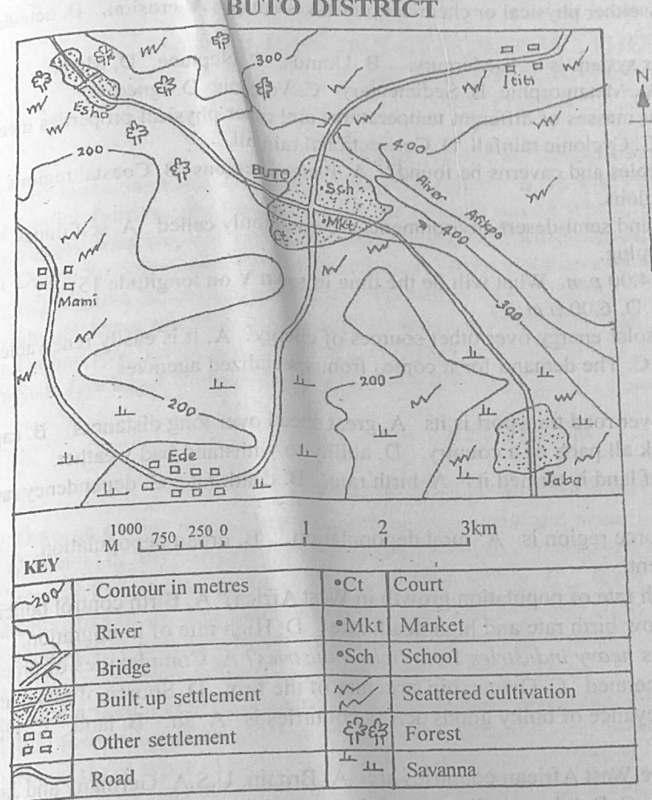
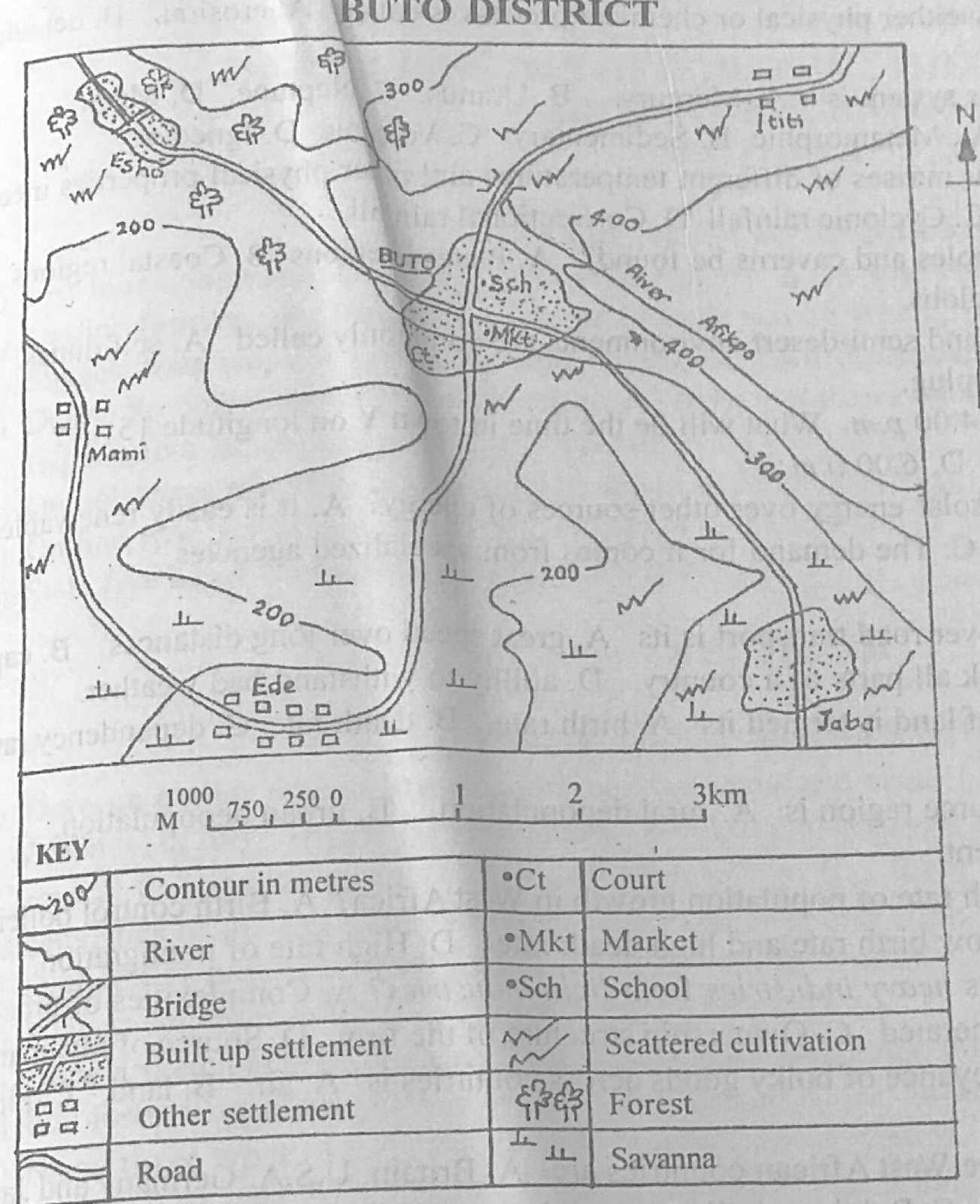
Study the map of BUTO DISTRICT to answer this question. What is the settlement pattern of Ede?

Diagram for this question
  1. A.Isolated
  2. B.Dispersed
  3. C.Annular
  4. D.Linear
Show the answer and explanation

Answer: D (Linear)

Explanation

Ede's houses are strung out in a line along the road: a linear pattern.

Open this question

Question 7

Relief and Map Interpretation

Study the map of BUTO DISTRICT to answer this question. What is the contour interval of the map?

Diagram for this question
  1. A.25 metres
  2. B.50 metres
  3. C.100 metres
  4. D.150 metres
Show the answer and explanation

Answer: C (100 metres)

Explanation

The contours are 200, 300 and 400 m, so the interval is 100 m.

Open this question

Question 8

Relief and Map Interpretation

Study the map of BUTO DISTRICT to answer this question. Which economic activity could be practised in the south-eastern part of the mapped area?

Diagram for this question
  1. A.Animal rearing
  2. B.Lumbering
  3. C.Trading
  4. D.Mining
Show the answer and explanation

Answer: A (Animal rearing)

Explanation

The south-east is savanna grassland, suitable for grazing animals.

Open this question

Question 9

Relief and Map Interpretation

Study the map of BUTO DISTRICT to answer this question. Which of the following modes of transport is commonly used in the mapped area?

Diagram for this question
  1. A.River
  2. B.Road
  3. C.Rail
  4. D.Air
Show the answer and explanation

Answer: B (Road)

Explanation

Only roads are shown linking the settlements.

Open this question

Question 10

Map Scale, Distance and Direction

Study the map of BUTO DISTRICT to answer this question. The distance by road from Mami to BUTO is approximately

Diagram for this question
  1. A.9.0km.
  2. B.14.0 km.
  3. C.23.0km.
  4. D.25.0 km.
Show the answer and explanation

Answer: A (9.0km.)

Explanation

Following the winding road from Mami to BUTO with a thread and comparing it with the linear scale gives about 9 km.

Open this question

Question 11

The Earth and Solar System

The hottest planet is

  1. A.venus
  2. B.pluto.
  3. C.mercury.
  4. D.Jupiter.
Show the answer and explanation

Answer: A (venus)

Explanation

Venus is the hottest planet because its thick carbon dioxide atmosphere traps heat (greenhouse effect), even though Mercury is nearer the sun.

Open this question

Question 12

The Earth and Solar System

When does eclipse of the moon occur?

  1. A.When the earth comes between the sun and the moon
  2. B.Whenever the earth rotates through 360°
  3. C.When the sun comes between the moon and the earth
  4. D.When the earth completes a revolution.
Show the answer and explanation

Answer: A (When the earth comes between the sun and the moon)

Explanation

A lunar eclipse happens when the earth's shadow falls on the moon, with the earth between the sun and the moon.

Open this question

Question 13

Earth Movements and Vulcanicity

The upfolded portion of a fold mountain is called

  1. A.Sial.
  2. B.Anticline.
  3. C.Syncline.
  4. D.Sill.
Show the answer and explanation

Answer: B (Anticline.)

Explanation

The upfold (arch) is an anticline; the downfold is a syncline.

Open this question

Question 14

Structure of the Earth

The part of the earth's crust which is made up of silica and alumina is the

  1. A.sima.
  2. B.mantle.
  3. C.barysphere.
  4. D.sial.
Show the answer and explanation

Answer: D (sial.)

Explanation

SIAL = SIlica + ALumina, the continental crust.

Open this question

Question 15

The Earth and Solar System

During equinox,

  1. A.the Tropic of Cancer experiences longer day than the Tropic of Capricon.
  2. B.all places across the globe experience equal lengths of day and night.
  3. C.the length of day at the Equator is shorter than at the Tropic of Cancer.
  4. D.the moon is star-shaped all through the night all over the world.
Show the answer and explanation

Answer: B (all places across the globe experience equal lengths of day and night.)

Explanation

At the equinoxes the sun is overhead at the Equator, so day and night are 12 hours each everywhere.

Open this question

Question 16

Earth Movements and Vulcanicity

Whenever volcanic eruption occurs,

  1. A.a new flat surface emerges.
  2. B.residual mountains are formed.
  3. C.over-thrust fold is formed.
  4. D.gases and molten magma are ejected.
Show the answer and explanation

Answer: D (gases and molten magma are ejected.)

Explanation

An eruption throws out gases, lava (molten magma), ash and rock fragments.

Open this question

Question 17

Coastal Landforms

The extent of coastal erosion depends on the

  1. A.amount of fresh water supplied by tributaries.
  2. B.depth of ocean water.
  3. C.salinity of the ocean.
  4. D.nature of the waves.
Show the answer and explanation

Answer: D (nature of the waves.)

Explanation

Strong destructive waves erode coasts most.

Open this question

Question 18

Rocks

Which of the following is a characteristic of igneous rock?

  1. A.Loose in composition
  2. B.Arranged in layers
  3. C.Crystalline in nature
  4. D.Porous in granular structure.
Show the answer and explanation

Answer: C (Crystalline in nature)

Explanation

Igneous rocks cool from magma and are made of crystals.

Open this question

Question 19

Weather

The temperature at the foot of a mountain is 20°C. If the mountain is 6000 meters above sea level, what will be the temperature at the top of the mountain?

  1. A.−19.0°C
  2. B.−16.0°C
  3. C.14.0°C
  4. D.19.0°C
Show the answer and explanation

Answer: A (−19.0°C)

Explanation

Temperature falls about 6.5°C per 1,000 m: 6 × 6.5 = 39°C, so 20 − 39 = −19°C.

Open this question

Question 20

Wind and Desert Landforms

Wind erosion is common in arid areas because

  1. A.rains are widespread and long lasting.
  2. B.wind speed is high and there are few wind breaks.
  3. C.pressure falls below normal in desert areas.
  4. D.the rocks are resistant to heat.
Show the answer and explanation

Answer: B (wind speed is high and there are few wind breaks.)

Explanation

Deserts have strong winds and little vegetation to break them or hold loose material, so wind erodes freely.

Open this question

Question 21

Rivers and River Landforms

Which of the following features could be found in the upper course of rivers?

  1. A.Ox-bow lakes
  2. B.Waterfall
  3. C.Deltas
  4. D.Levees
Show the answer and explanation

Answer: B (Waterfall)

Explanation

Waterfalls form where the steep young river crosses hard rock; the others are lower-course features.

Open this question

Question 22

Earth Movements and Vulcanicity

Ash and cinder cones are associated with

  1. A.ozone depletion.
  2. B.hurricane's activities.
  3. C.earthquakes.
  4. D.volcanic eruption.
Show the answer and explanation

Answer: D (volcanic eruption.)

Explanation

Ash and cinder cones are built from material thrown out by volcanoes.

Open this question

Question 23

Wind and Desert Landforms

Deposition of fine grained sand carried over long distance by wind is known as

  1. A.chernozem.
  2. B.laterite
  3. C.loess.
  4. D.podzols.
Show the answer and explanation

Answer: C (loess.)

Explanation

Loess is fine wind-blown dust deposited far from its source, e.g. in northern China.

Open this question

Question 24

Structure of the Earth

The core of the earth is also called

  1. A.mesosphere.
  2. B.lithosphere.
  3. C.hydrosphere.
  4. D.barysphere.
Show the answer and explanation

Answer: D (barysphere.)

Explanation

The dense central core is called the barysphere.

Open this question

Question 25

Environmental Resources

Which of the following environmental resources is non-renewable?

  1. A.Rain
  2. B.Minerals
  3. C.Water
  4. D.Oxygen.
Show the answer and explanation

Answer: B (Minerals)

Explanation

Minerals are used up once mined; rain, water and oxygen are renewed naturally.

Open this question

Question 26

Weather

Relief rainfall is common around the

  1. A.lowland areas.
  2. B.peneplains.
  3. C.highland areas.
  4. D.Sahara Desert.
Show the answer and explanation

Answer: C (highland areas.)

Explanation

Relief rain forms when moist air is forced to rise over highlands.

Open this question

Question 27

Earth Movements and Vulcanicity

Which of the following features is of volcanic origin?

  1. A.Sill
  2. B.Zeugen
  3. C.Loess
  4. D.Gorge.
Show the answer and explanation

Answer: A (Sill)

Explanation

A sill is magma that cooled between rock layers; the others come from erosion or deposition.

Open this question

Question 28

Weather

The instrument used for measuring atmospheric pressure is

  1. A.hygrometer.
  2. B.barometer.
  3. C.thermometer.
  4. D.anemometer.
Show the answer and explanation

Answer: B (barometer.)

Explanation

A barometer measures air pressure.

Open this question

Question 29

Weathering, Erosion and Mass Movement

The gradual breakdown of rocks in situ by either physical or chemical process is called

  1. A.erosion.
  2. B.denudation.
  3. C.weathering.
  4. D.deposition.
Show the answer and explanation

Answer: C (weathering.)

Explanation

Weathering breaks rocks down where they lie, without moving them.

Open this question

Question 30

The Earth and Solar System

The fourth planet from the sun in the solar system is

  1. A.Mercury.
  2. B.Uranus.
  3. C.Neptune.
  4. D.Mars.
Show the answer and explanation

Answer: D (Mars.)

Explanation

Mercury, Venus, Earth, then Mars.

Open this question

Question 31

Rocks

Which rock type involves stratification?

  1. A.Metamorphic
  2. B.Sedimentary
  3. C.Volcanic
  4. D.Igneous.
Show the answer and explanation

Answer: B (Sedimentary)

Explanation

Sedimentary rocks are laid down in layers (strata).

Open this question

Question 32

Weather

Which type of rainfall occurs when two air masses of different temperatures and other physical properties meet?

  1. A.Orographic rainfall
  2. B.Relief rainfall
  3. C.Cyclonic rainfall
  4. D.Convectional rainfall.
Show the answer and explanation

Answer: C (Cyclonic rainfall)

Explanation

Where warm and cold air masses meet, the warm air rises over the cold: cyclonic (frontal) rain.

Open this question

Question 33

Underground Water and Karst

In which regions can stalactites, swallow holes and caverns be found?

  1. A.Plateau regions
  2. B.Coastal regions
  3. C.Mountainous regions
  4. D.Limestone regions.
Show the answer and explanation

Answer: D (Limestone regions.)

Explanation

These are karst features formed by solution of limestone.

Open this question

Question 34

Wind and Desert Landforms

The remains of eroded highlands in desert and semi-desert environments are commonly called

  1. A.seif dunes.
  2. B.barchans.
  3. C.inselbergs.
  4. D.volcanic plug.
Show the answer and explanation

Answer: C (inselbergs.)

Explanation

Inselbergs are isolated residual hills left after the land around them was worn down.

Open this question

Question 35

Latitude, Longitude and Time

The time in town X on Longitude 15 °E is 4.00 p.m. What will be the time in town Y on longitude 15 °W?

  1. A.2.00 am.
  2. B.2.00 p.m.
  3. C.6.00 p.m.
  4. D.6.00 a.m.
Show the answer and explanation

Answer: B (2.00 p.m.)

Explanation

The difference is 30°, i.e. 30 × 4 = 120 minutes; Y is west, so its time is 2 hours behind: 2.00 p.m.

Open this question

Question 36

Mining and Energy

Which of the following is an advantage of solar energy over other sources of energy?

  1. A.It is easily renewable
  2. B.It requires physical gradient difference
  3. C.The demand for it comes from specialized agencies
  4. D.Its waste is difficult to manage.
Show the answer and explanation

Answer: A (It is easily renewable)

Explanation

Sunshine is never used up, so solar energy is renewable.

Open this question

Question 37

Transport, Trade and Tourism

One relative advantage of water transport over road transport is its

  1. A.great speed over long distances.
  2. B.capacity for carrying bulky goods.
  3. C.ability' to link all parts of a country.
  4. D.ability to withstand bad weather.
Show the answer and explanation

Answer: B (capacity for carrying bulky goods.)

Explanation

Ships and barges can carry very large, heavy loads cheaply.

Open this question

Question 38

Population

The number of people living in a unit area of land is termed its

  1. A.birth rate.
  2. B.death rate.
  3. C.dependency ratio.
  4. D.population density.
Show the answer and explanation

Answer: D (population density.)

Explanation

Population density = people per unit area.

Open this question

Question 39

Population

An effect of rural-urban migration on the source region is

  1. A.rural depopulation.
  2. B.urban depopulation.
  3. C.rural employment.
  4. D.rural unemployment.
Show the answer and explanation

Answer: A (rural depopulation.)

Explanation

When people leave villages for towns, the villages lose population.

Open this question

Question 41

Manufacturing Industry

Which of the following features distinguishes heavy industries from light industries?

  1. A.Complexities of processing techniques
  2. B.Amount of waste products generated
  3. C.Ownership structure of the firm
  4. D.Source of raw materials.
Show the answer and explanation

Answer: A (Complexities of processing techniques)

Explanation

Heavy industries use complex processes and machinery on bulky raw materials; light industries use simpler processes.

Open this question

Question 42

Transport, Trade and Tourism

The cheapest mode of transport for the conveyance of bulky goods across countries is

  1. A.air.
  2. B.land.
  3. C.pipeline.
  4. D.water.
Show the answer and explanation

Answer: D (water.)

Explanation

Ships carry bulky goods long distances at the lowest cost per tonne.

Open this question

Question 43

West Africa and ECOWAS

The major trading partners of the Anglophone West African countries are

  1. A.Britain. U.S.A. Germany and Japan.
  2. B.Germany, China, South Africa and Norway
  3. C.Belgium, India. Columbia and Chile.
  4. D.Chile, Pakistan. Japan and Britain.
Show the answer and explanation

Answer: A (Britain. U.S.A. Germany and Japan.)

Explanation

English-speaking West African countries trade mainly with Britain, the U.S.A. and other industrial countries such as Germany and Japan.

Open this question

Question 44

Settlement

Which of the following is true of inter community relationship?

  1. A.Females migrate to rural areas to give birth
  2. B.Youth migrate to urban areas in search of jobs
  3. C.Immigrants settle in the city's Central Business District
  4. D.City dwellers seek schools for their children in rural areas.
Show the answer and explanation

Answer: B (Youth migrate to urban areas in search of jobs)

Explanation

Young people move from villages to towns looking for work.

Open this question

Question 45

Population

If a country has a population of 20,000,000 and its size is 1,000.000 km2, then its population density is

  1. A.5 persons / km2.
  2. B.15 persons / km2.
  3. C.20 persons / km2.
  4. D.30 persons / km2.
Show the answer and explanation

Answer: C (20 persons / km2.)

Explanation

20,000,000 ÷ 1,000,000 = 20 persons per km².

Open this question

Question 47

Transport, Trade and Tourism

One of the usefulness of import tariff on imported goods is the

  1. A.encouragement of importation from abroad.
  2. B.multiplication of foreign goods in local markets.
  3. C.protection of infant industries.
  4. D.saving of money in foreign accounts.
Show the answer and explanation

Answer: C (protection of infant industries.)

Explanation

Tariffs make imports dearer, protecting young local industries from foreign competition.

Open this question

Question 48

West Africa and ECOWAS

One of the problems limiting the achievement of the objectives of the Economic Community of West Africa States is

  1. A.use of common currency.
  2. B.strong colonial ties.
  3. C.climatic differences.
  4. D.similarity in languages.
Show the answer and explanation

Answer: B (strong colonial ties.)

Explanation

Member states keep strong ties with their former colonial powers (Britain, France), which weakens trade and cooperation among themselves.

Open this question

Question 49

Agriculture, Fishing and Lumbering

Cattle ranching is not common in the forest regions of West Africa because of the

  1. A.scarcity of grass for fodder.
  2. B.presence of tsetse flies.
  3. C.absence of Fulani herdsmen.
  4. D.presence of wild life.
Show the answer and explanation

Answer: B (presence of tsetse flies.)

Explanation

Tsetse flies in the forest spread sleeping sickness (trypanosomiasis) to cattle.

Open this question

Question 50

Agriculture, Fishing and Lumbering

The location of market gardening near large cities is best explained by

  1. A.availability of power.
  2. B.fertile soil
  3. C.perishability of products
  4. D.efficient transportation.
Show the answer and explanation

Answer: C (perishability of products)

Explanation

Vegetables and fruits spoil quickly, so they are grown close to the city markets.

Open this question

Theory question 101

Transport, Trade and Tourism

(a) List four commodities exported from your country to any one European country. (b) Outline four reasons for the low volume of trade among West African countries. (c) Suggest four ways of improving trade among West African countries.

Show the model answer
Model answer

(a) (Nigeria to e.g. Britain) Crude oil; cocoa; rubber; palm produce; groundnuts; cotton; hides and skins; tin and columbite; timber; sesame/cashew.
(b) Countries produce similar (primary) goods; poor transport and communication links between countries; different currencies and lack of convertibility; tariffs, border controls and trade restrictions; colonial ties that direct trade to Europe; political instability and border closures; low level of industrialisation; preference for foreign goods; language differences.
(c) Build roads and railways linking member states (e.g. Trans-West African Highway); remove tariffs and trade barriers (ECOWAS trade liberalisation); introduce a common or convertible currency; diversify and industrialise to produce different goods; improve the quality of local goods; political stability and good governance; encourage cross-border investment; ease border formalities.

Explanation

Name a real European country and real exports.

Open this question

Theory question 102

Population

(a) Define the following terms: (i) death rate; (ii) population explosion. (b) Explain five factors that influence death rate in Tropical Africa. (c) Outline three effects of a growing population in Tropical Africa.

Show the model answer
Model answer

(a)(i) Death rate: the number of deaths per 1,000 people in a year.
(ii) Population explosion: a very rapid increase in population caused by a high birth rate and a falling death rate.
(b) Health care: more hospitals, vaccination and drugs lower deaths; diseases such as malaria, HIV/AIDS, cholera raise deaths; food supply and nutrition (famine raises deaths); water supply and sanitation; level of education and income; wars and conflicts; natural disasters (drought, floods); age structure of the population; accidents.
(c) Pressure on social amenities (schools, hospitals, water); unemployment; housing shortage and slums; food shortage; crime; environmental degradation; more labour and larger markets (positive).

Explanation

Explain each factor: say how it raises or lowers deaths.

Open this question

Theory question 103

Manufacturing Industry

(a) Outline five factors that should be considered in the location of an industry. (b) State five benefits of industrialization to a country.

Show the model answer
Model answer

(a) Raw materials; market; power supply; labour (skilled and unskilled); capital; transport and communication; water supply; government policy and incentives; land/site; political stability; security; industrial inertia and existing industries.
(b) Employment; higher incomes and standard of living; use of local raw materials; foreign exchange earned or saved; diversification of the economy; development of infrastructure; growth of towns; acquisition of technology and skills; revenue for government; reduced dependence on imports.

Explanation

Five distinct points in each part.

Open this question

Theory question 104

Nigeria: Physical Setting

(a) Draw an outline map of Nigeria. On the map, show and name: (i) the position of Tropical Maritime air mass (S.W. Winds) in July; (ii) the position of Inter Tropical Convergence Zone (I. T. C. Z) in July; (iii) the relative position of Tropical Continental air mass (N. E. Winds) in July; (iv) three towns located in 4(a)(i) above. (b) State four characteristics of the wet season in Nigeria. (c) List two cash crops grown during the wet season in Nigeria.

Show the model answer
Model answer

(a) Map: in July the ITCZ lies far north, near the northern border of Nigeria (about latitude 20°N, north of Nigeria or across its far north); the south-west (Tropical Maritime) winds cover almost the whole country south of it, shown by arrows from the Atlantic; the north-east (Tropical Continental) winds lie north of the ITCZ; three towns in the SW-wind zone, e.g. Lagos, Ibadan, Enugu, Port Harcourt, Kano.
(b) Tropical maritime air mass (south-west winds) blows over the country; heavy rainfall, decreasing from south to north; high relative humidity; cloudy skies; slightly lower temperatures than in the dry season; thunderstorms and line squalls at its start and end; longer in the south (up to 8-9 months) than the north (3-4 months); little August break in the south-west.
(c) Cocoa, cotton, groundnuts, rubber, oil palm, soya beans, ginger, sesame.

Explanation

Put the July ITCZ well to the north.

Open this question

Theory question 105

Nigeria: People and Economy

(a) Outline five problems of agricultural development in Nigeria. (b) Suggest solutions to the problems outlined in 5(a) above.

Show the model answer
Model answer

(a) Inadequate capital and credit for farmers; poor (crude) farming tools and low mechanisation; poor rural roads and storage, so crops rot; land tenure system and fragmented holdings; pests and diseases; soil infertility and erosion; unreliable rainfall, floods and drought; rural-urban migration of youths; poor pricing and marketing; low use of fertilisers and improved seeds; insecurity (farmer-herder conflict).
(b) Give farmers loans and grants (agricultural banks); supply tractors and modern tools; build rural roads, storage and processing facilities; reform land tenure (Land Use Act, consolidation); provide pesticides and veterinary services; use fertilisers and crop rotation; irrigation; provide rural amenities to keep youths; guaranteed prices and marketing boards; extension services and research.

Explanation

Match each solution to a problem.

Open this question

Theory question 106

Nigeria: Physical Setting

(a) Draw a sketch map of Nigeria. On the map, show and name one area with: (i) Mangrove swamp vegetation; (ii) Rain forest vegetation; (iii) Guinea savanna vegetation; (iv) Sudan savanna vegetation. (b) Name three types of trees found in the forest zone of Nigeria. (c) Explain four contributions of forest vegetation to the economic development of Nigeria.

Show the model answer
Model answer

(a) Map: mangrove swamp along the coast and the Niger Delta (e.g. Rivers, Bayelsa, Lagos lagoons); rain forest belt inland in the south (Ondo, Edo, Cross River, Ogun); Guinea savanna across the middle belt (Kwara, Niger, Benue, Plateau, FCT); Sudan savanna in the north (Kano, Katsina, Sokoto, Zamfara).
(b) Mahogany, iroko, obeche, sapele, walnut, abura, afara, camwood, oil palm.
(c) Timber for building, furniture and export (foreign exchange); raw materials for industries (sawmills, plywood, paper, match); employment for lumbermen, carpenters and traders; food, fruits and bush meat; herbs for medicine; fuel wood and charcoal; tourism (forest reserves, parks); protects soil from erosion and supports rainfall.

Explanation

Explain each contribution, not just list it.

Open this question

Theory question 302

Statistical Maps and Diagrams

The data below shows the number of farmers who cultivated the underlisted crops in Ajok Region from 2005 to 2007.
2005: Cassava 50; Maize 60; Rice 45; Yam 80
2006: Cassava 40; Maize 62; Rice 55; Yam 48
2007: Cassava 48; Maize 58; Rice 70; Yam 35
(a) Draw a divided bar graph to represent the data. (b) Calculate the number of farmers who cultivated rice from 2005 to 2007. (c) What is the major difference between simple bar graph and the component/divided bar graph?

Show the model answer
Model answer

(a) Totals: 2005 = 235; 2006 = 205; 2007 = 211. Draw one bar per year with heights to a scale (e.g. 1 cm = 20 farmers), each divided into cassava, maize, rice and yam in the same order, with cumulative values (2005: 50, 110, 155, 235; 2006: 40, 102, 157, 205; 2007: 48, 106, 176, 211); equal bar widths and gaps, shading key, title and labelled axes.
(b) 45 + 55 + 70 = 170 farmers.
(c) A simple bar graph shows only one value (the total) per bar, while a divided bar graph splits each bar into components showing how the total is made up.

Explanation

Keep the order of the crops the same in every bar.

Open this question

Theory question 303

The Earth and Solar System

(a) Explain the following terms: (i) rotation of the earth; (ii) revolution of the earth; (iii) equinox. (b) Outline three effects of the revolution of the earth.

Show the model answer
Model answer

(a)(i) Rotation: the spinning of the earth on its axis from west to east, once in 24 hours.
(ii) Revolution: the movement of the earth round the sun in its elliptical orbit, once in about 365¼ days.
(iii) Equinox: the time (about 21 March and 23 September) when the sun is overhead at the Equator and day and night are equal everywhere.
(b) Seasons; varying lengths of day and night through the year; apparent movement of the overhead sun between the tropics; changing altitude of the midday sun; leap year every four years; perihelion and aphelion; the equinoxes and solstices.

Explanation

Three effects of revolution, not of rotation.

Open this question

Theory question 304

Rivers and River Landforms

(a) List three landforms found in the upper course of a river valley. (b) With the aid of diagrams, describe the characteristics and mode of formation of an ox-bow lake.

Show the model answer
Model answer

(a) V-shaped valley; gorge; waterfall; rapids; potholes; interlocking spurs.
(b) Characteristics: crescent (horse-shoe) shaped lake; found on the floodplain in the lower course; cut off from the main river; shallow and often becomes a swamp as it silts up.
Formation: the river forms large meanders; erosion on the outer (concave) bank and deposition on the inner (convex) bank make the meander loop bigger and the neck narrower; during a flood the river cuts through the narrow neck and takes the shorter straight course; deposition seals off the ends of the old loop, leaving an ox-bow lake. Diagrams: meander with narrow neck; river breaking through; ox-bow lake left beside the new channel.

Explanation

Draw the stages in order.

Open this question

Theory question 305

Earth Movements and Vulcanicity

(a) List any three types of mountains. (b) In what four ways are mountains important to man? (c) Outline two problems caused by mountains.

Show the model answer
Model answer

(a) Fold mountains; block mountains; volcanic mountains; residual mountains.
(b) Sources of rivers and water for HEP and irrigation; minerals; tourism and recreation (cool climate, scenery); relief rainfall on windward slopes; forests and timber; grazing land; defence/security; natural boundaries.
(c) Barriers to transport and communication; steep slopes and thin soils limit farming; soil erosion and landslides; volcanic eruptions and earthquakes; rain shadow areas are dry; sparse population.

Explanation

Give examples of mountains where you can.

Open this question

Theory question 306

Climate

(a) Define climate. (b) Describe the three climatic belts recognized by the Greek system of classification. (c) Outline three reasons why koppen's system of climatic classification is the most widely accepted.

Show the model answer
Model answer

(a) Climate is the average weather conditions of a place over a long period (about 30-35 years).
(b) Torrid zone: between the Tropics of Cancer and Capricorn, hot all year with the overhead sun; temperate zones: between the tropics and the Arctic/Antarctic Circles, with warm summers and cool winters; frigid zones: from the Arctic and Antarctic Circles to the poles, cold all year.
(c) Based on measurable data (temperature and rainfall) that are widely available; uses simple letter codes; relates climate to natural vegetation; can be applied to any place in the world; has clear, precise boundaries between types; can be modified (sub-types).

Explanation

Name each Greek zone with its latitudes.

Open this question

Theory question 307

Environmental Hazards and Conservation

(a) What are environmental hazards? (b) List three examples of environmental hazards. (c) Explain five ways of preventing desert encroachment.

Show the model answer
Model answer

(a) Natural or man-made events that cause serious danger to life, property and the environment.
(b) Floods; drought; desertification; soil erosion; earthquakes; volcanic eruptions; landslides; pollution; bush fires; storms.
(c) Afforestation and shelter belts; control of overgrazing; control of bush burning; reduced cutting of trees for fuel, using alternative energy; irrigation; sand-dune fixation; public education; laws against deforestation; proper farming methods (fallowing, mulching); international cooperation (Great Green Wall).

Explanation

Explain how each method stops the desert advancing.

Open this question

Theory question 308

Coastal Landforms

(a) List three features of coastal erosion. (b) With the aid of diagrams, describe the characteristics and mode of formation of a beach.

Show the model answer
Model answer

(a) Cliff; wave-cut platform; cave; arch; stack; stump; geo; blow hole.
(b) Characteristics: gently sloping accumulation of sand, shingle or pebbles between high and low water marks; coarse material at the back (landward) and fine near the sea; may have ridges (berms) and ripple marks; found in bays.
Formation: constructive waves with strong swash and weak backwash carry sand and pebbles up the shore and leave them; longshore drift moves material along the coast; deposition is greatest in sheltered bays; material comes from erosion of cliffs and from rivers. Diagram: cross-section of a beach showing swash, backwash and sorted materials.
Explanation

Explain swash and backwash.

Open this question