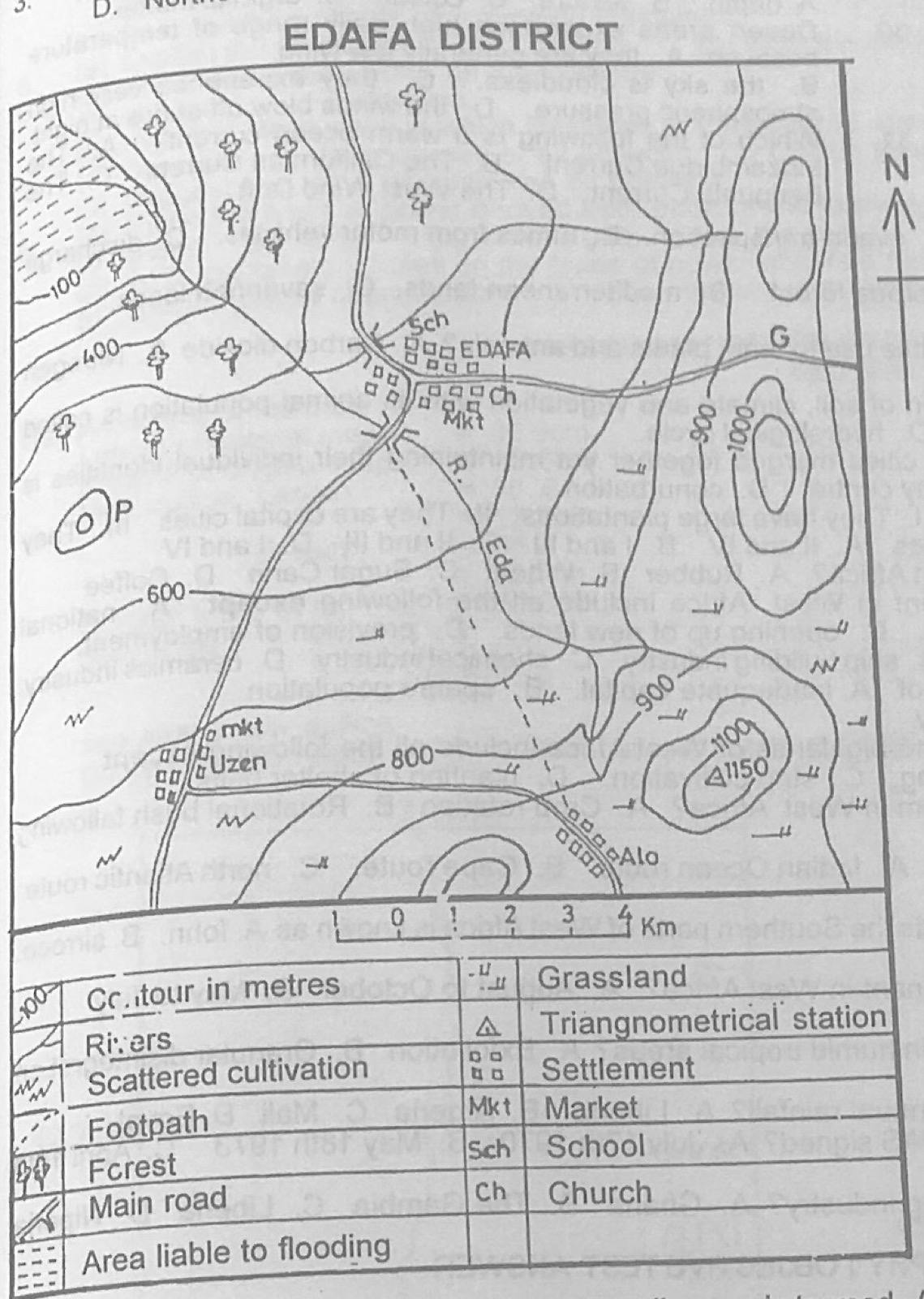
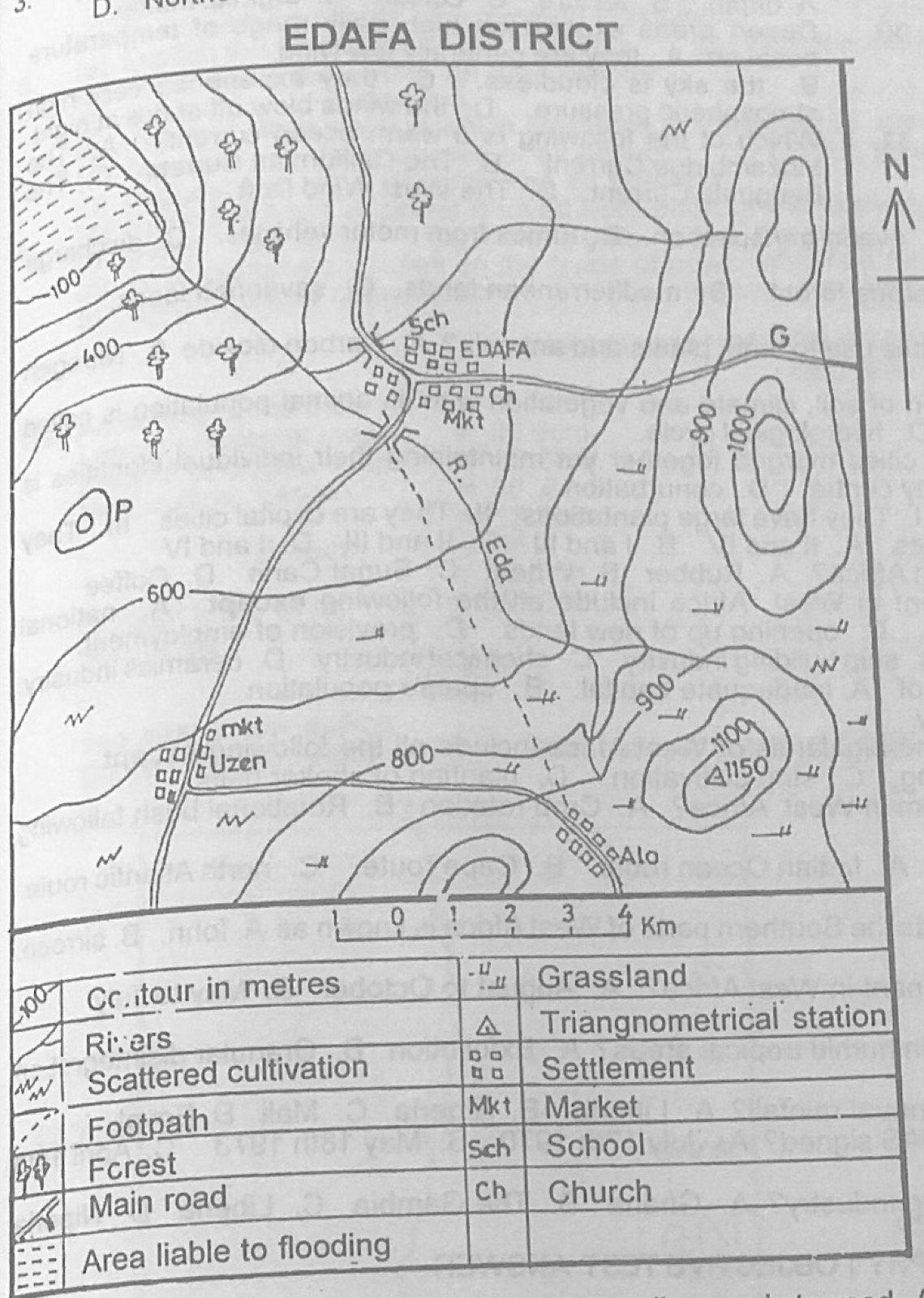
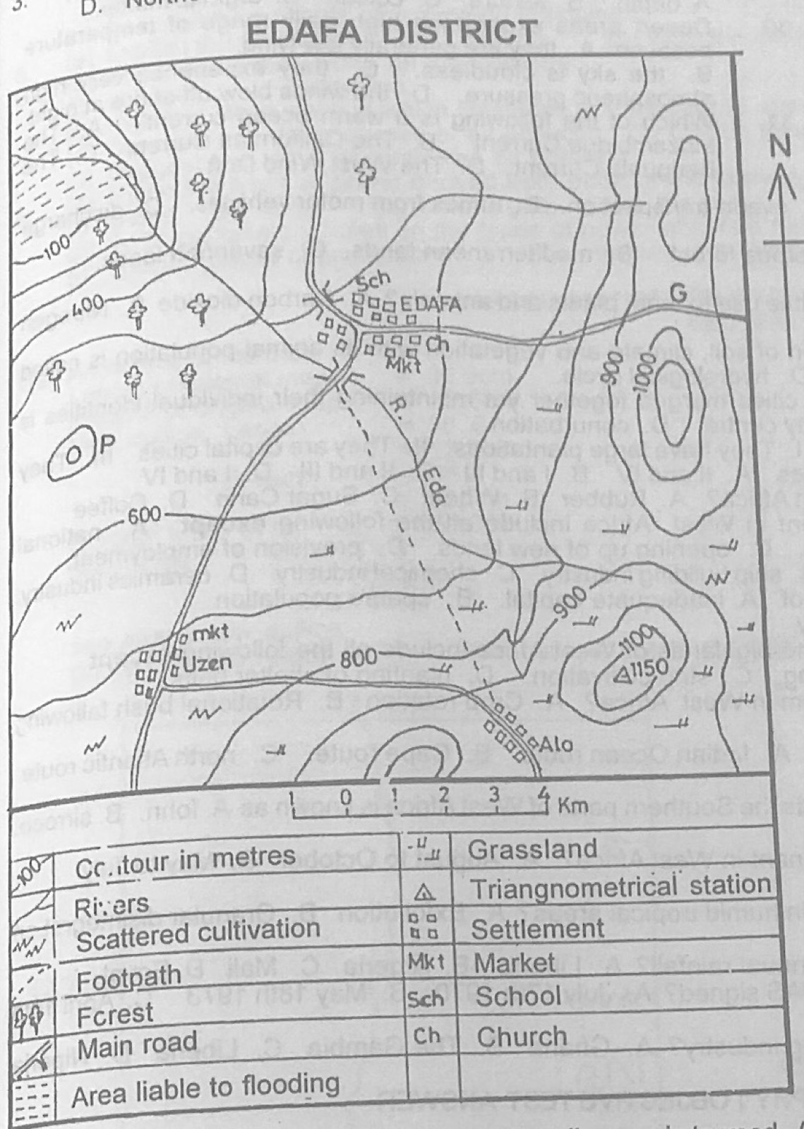
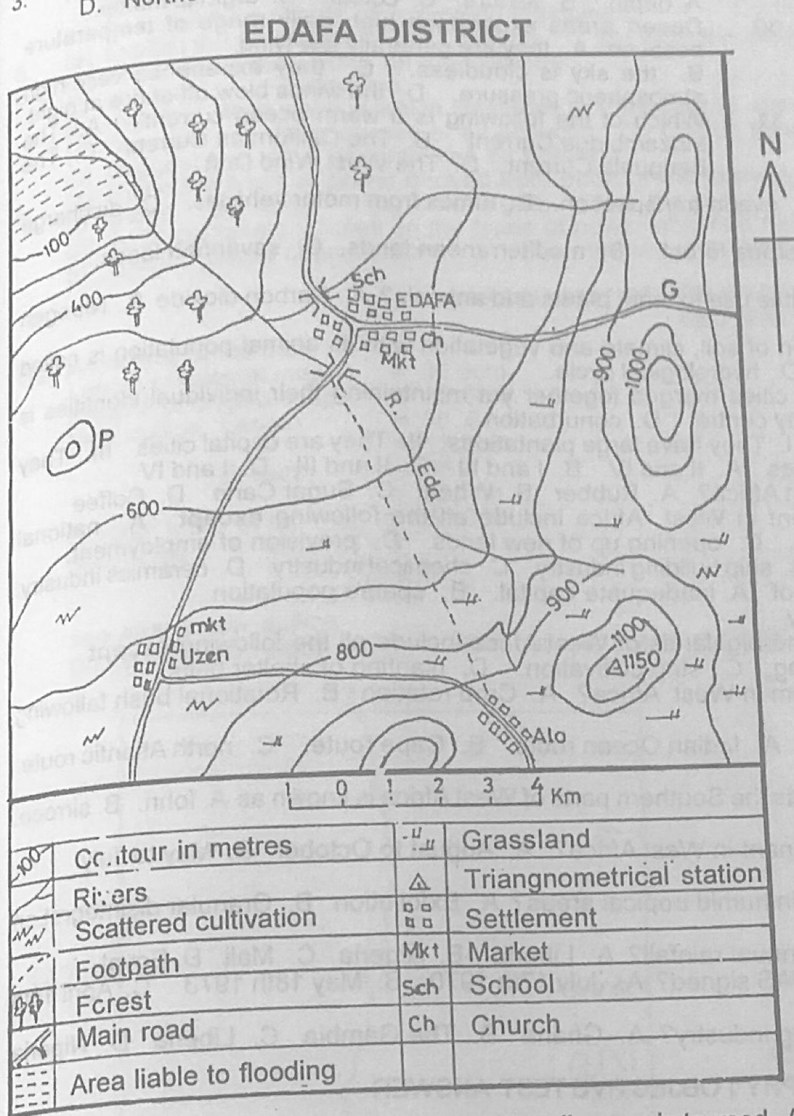
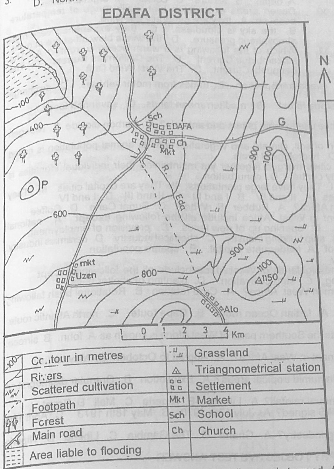
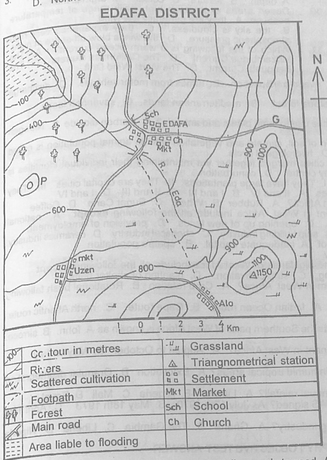
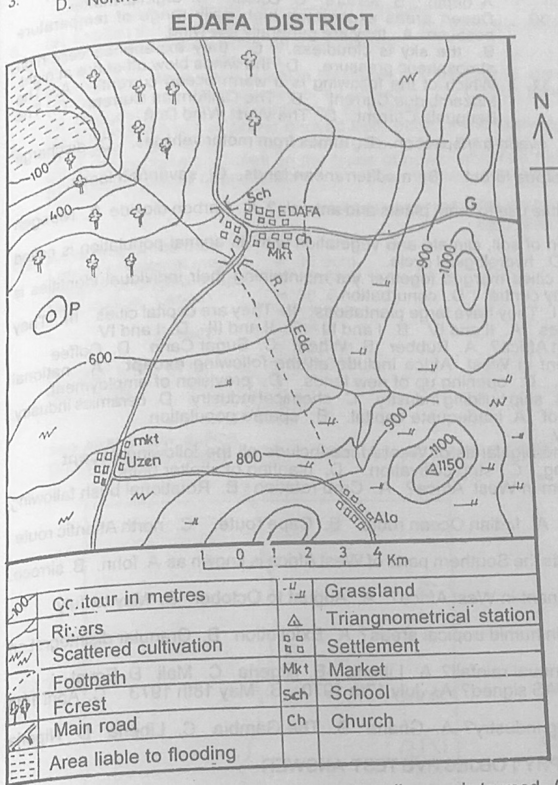
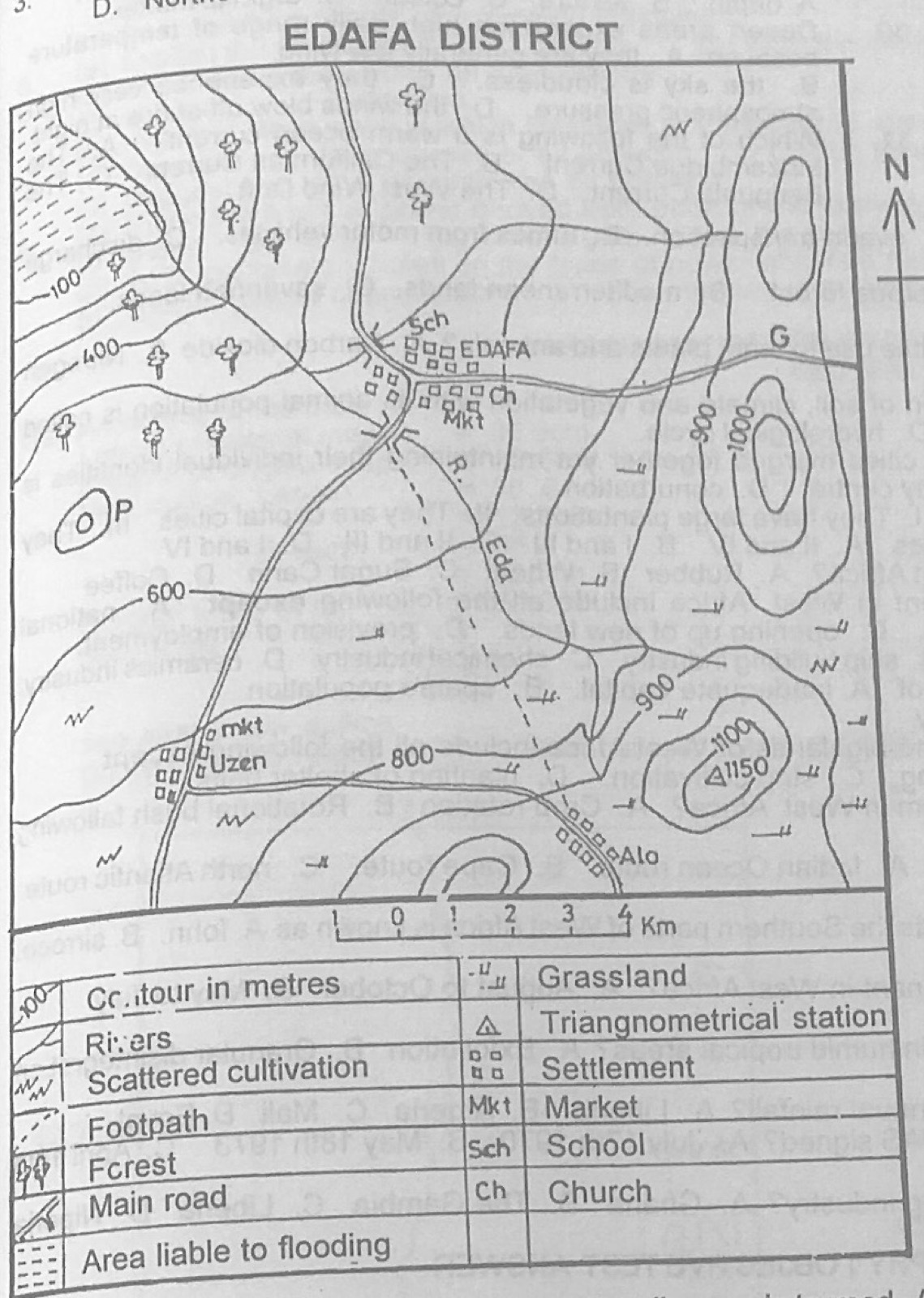
Study the map of EDAFA DISTRICT to answer this question. River Eda flows from
A.Southeast to Northwest.
B.Southwest to Northwest.
C.Northwest to Southwest.
D.Northeast to Southeast.
Show the answer and explanation
Answer: A (Southeast to Northwest.)
Explanation
The land is high in the south-east (over 1,000 m) and low in the north-west (100 m, area liable to flooding), so the river flows from south-east to north-west.
Which of the following are true of most large cities? I. They have large plantations II. They are capital cities III. They are religious centres IV. They are commercial centres
A.II and IV
B.I and III
C.II and III
D.I and IV
Show the answer and explanation
Answer: A (II and IV)
Explanation
Most large cities are capitals and commercial centres; they do not have plantations and are not mainly religious centres.
(a) (i) Define the term migration. (ii) Name four types of migration in Africa. (b) Outline any four causes of migration in Africa. (c) Suggest any three ways by which migration can be reduced in Africa.
Show the model answer
Model answer
(a)(i) Migration is the movement of people from one place to another to live, temporarily or permanently. (ii) Rural-urban; rural-rural; urban-urban; urban-rural; seasonal; international (emigration/immigration); nomadic. (b) Search for jobs and better income; education; better social amenities in towns; wars, conflicts and political unrest; natural disasters (drought, floods, famine); population pressure on land; religious persecution or pilgrimage; marriage and family; pastoral nomadism. (c) Provide social amenities in rural areas (water, electricity, schools, hospitals); rural industries and jobs; improve agriculture and give loans to farmers; political stability and good governance; poverty alleviation programmes; quick response to disasters; laws on immigration.
(a) Write notes on: (i) dispersed settlement; (ii) linear settlement. (b) Explain any four factors that favour the location of settlements. (c) Outline any three functions of urban settlement.
Show the model answer
Model answer
(a)(i) Dispersed settlement: houses scattered singly or in small groups, far apart, separated by farmland; common in rural farming areas with plenty of land, security and water everywhere; few amenities; e.g. parts of the middle belt. (ii) Linear settlement: houses arranged in a line along a road, railway, river, coast or valley; houses face the route with farms behind; easy access to transport and trade. (b) Water supply; fertile land; relief (flat, well-drained, flood-free, defence sites on hills); route centres and nodal points; mineral resources; good climate; security/defence; ports and harbours; government policy (capitals). (c) Administrative; commercial (markets, banks); industrial; educational; health; religious; residential; transport; recreational and cultural.
(a) Highlight five advantages that air transport has over other means of transportation. (b) Explain five problems limiting air transportation in your country.
Show the model answer
Model answer
(a) Fastest means of transport; not blocked by mountains, seas, deserts or forests; good for perishable, light and valuable goods; reaches remote areas; links countries and continents quickly; comfortable; good for emergencies, mail and tourism; little infrastructure needed between airports. (b) (Nigeria) High cost of aircraft, fuel and fares; few modern airports and poor facilities; bad weather (harmattan haze, storms) disrupts flights; accidents and poor safety record; shortage of skilled personnel; poor management and corruption; carries only small loads; few routes and connections; power failures at airports; insecurity.
(a) Draw an outline map of Nigeria. On the map, mark and name: (i) latitudes 5°N, 13°N and longitude 8°E; (ii) one area with rainfall of about 600 mm; (iii) one area with rainfall between 2000 mm and 3050 mm; (iv) One town in each of the areas in (ii) and (iii) above. (b) Describe the rainfall pattern in Nigeria.
Show the model answer
Model answer
(a) Map: latitude 5°N near the coast (Niger Delta), 13°N across the far north (Sokoto, Kano area, through Katsina), longitude 8°E through Kano/Kaduna and Calabar area; about 600 mm in the far north (e.g. Sokoto, Katsina, Maiduguri, Nguru); 2000-3050 mm on the south-east coast (Port Harcourt, Calabar, Warri, Bonny). (b) Rainfall decreases from the coast (over 2,000 mm) to the north (under 500 mm); the length of the rainy season falls from about 8-12 months in the south to 3-4 months in the north; the south has two peaks (double maximum) with the 'August break', the north has one peak (single maximum) in August; rain comes with the south-west monsoon (tropical maritime air mass); the north-east has the least; rainfall is mainly convectional, with relief rain on highlands (Jos, Obudu).
(a) Draw a sketch map of Nigeria. On the map, show and name: (i) the North Central Highlands; (ii) the rivers Niger and Benue. (b) Name two export crops and four food crops of the North Central Highlands. (c) Describe the North Central Highlands under the following headings: (i) agricultural activities; (ii) problems of development.
Show the model answer
Model answer
(a) Map with the North Central Highlands (Jos Plateau and surrounding high plains of Hausaland, in Plateau, Kaduna, Kano, Bauchi area); River Niger entering from the north-west to Lokoja and the delta; River Benue from the east joining at Lokoja. (b) Export: cotton, groundnuts, soya beans, ginger, tobacco. Food: maize, guinea corn (sorghum), millet, yams, Irish potatoes, acha, rice, vegetables. (c)(i) Mixed farming; grain and root crops; Irish potatoes and temperate vegetables on the cool plateau; cattle rearing by the Fulani (tsetse-free, cool); dry season irrigated farming (fadama); dairy farming (Vom). (ii) Poor, leached, eroded soils (mining spoils); subsistence farming; pests (locusts) and diseases (river blindness, meningitis); poor roads in rugged areas; ethnic and farmer-herder conflicts; mining wasteland; inadequate capital.
(a) Draw a sketch map of Nigeria. On the map, locate and name: (i) Jos Plateau, Oban Hills and Mandara Mountains; (ii) Rivers Ogun and Gongola. (b) Describe the location and size of Nigeria. (c) Highlight three economic importance of highlands to the economy of Nigeria.
Show the model answer
Model answer
(a) Map: Jos Plateau (centre-north), Oban Hills (south-east near Calabar, Cross River), Mandara Mountains (north-east on the Cameroon border); River Ogun (south-west, flowing to Lagos lagoon); River Gongola (north-east, tributary of the Benue). (b) Nigeria lies in West Africa between latitudes 4°N and 14°N and longitudes 3°E and 15°E; bordered by Benin (west), Niger (north), Chad (north-east), Cameroon (east) and the Atlantic Ocean/Gulf of Guinea (south); area about 923,768 km²; about 1,100 km north-south and 1,300 km east-west; largest population in Africa. (c) Source of rivers and HEP sites; minerals (tin and columbite on Jos Plateau); cool climate for tourism, settlement and temperate crops (Jos, Obudu Cattle Ranch); grazing land; forests and wildlife; climatic and defence barriers; relief rainfall.
(a) Draw an outline map of Africa. On the map, show and name: (i) the Kainji Dam; (ii) Aswan Dam; (iii) Drakensberg Mountains. (iv) the Atlas Mountains. (b) Outline five importance of hydroelectric power to the economy of African countries.
Show the model answer
Model answer
(a) Map: Kainji Dam on the River Niger in western Nigeria; Aswan (High) Dam on the Nile in southern Egypt; Drakensberg Mountains in south-east South Africa/Lesotho; Atlas Mountains in north-west Africa (Morocco, Algeria, Tunisia). (b) Cheap, renewable power for industries; electricity for homes and towns; rural electrification; reduces use of fuelwood and saves forests; reservoirs used for irrigation, fishing and transport; flood control; employment; tourism; export of power earns foreign exchange (e.g. Ghana to Togo/Benin); attracts industries such as aluminium smelting (Tema).
(a) Draw a sketch map of Africa. On it show and name: (i) Cameroun Highlands; (ii) Fouta Djallon Highlands; (iii) one important river that takes its source from any of the highlands named in (a)(i) and (ii) above. (b) Highlight four ways in which rivers are important to the economy of Africa. (c) Outline three problems limiting the use of African rivers.
Show the model answer
Model answer
(a) Map: Cameroun Highlands on the Nigeria-Cameroon border; Fouta Djallon in Guinea; river: Niger, Senegal or Gambia (from Fouta Djallon) or Benue (from Cameroun Highlands). (b) Transport and navigation; hydro-electric power; irrigation; fishing; domestic and industrial water supply; tourism and recreation; fertile floodplains for farming; boundaries. (c) Rapids, waterfalls and cataracts; seasonal fluctuation in volume; sandbars and silting at mouths; water weeds (water hyacinth); flow through sparsely populated areas; diseases (river blindness, bilharzia); lack of capital for development.
Explanation
Show the river starting in the highland you named.
(a) Identify any four factors that favour lumbering in Democratic Republic of Congo. (b) Explain any four problems of lumbering in Democratic Republic of Congo. (c) Outline two ways in which any of the problems in (b) above could be solved.
Show the model answer
Model answer
(a) Large area of tropical rainforest in the Congo basin; valuable hardwoods (mahogany, sapele, limba, ebony); rivers (Congo and tributaries) for floating logs; ports such as Matadi and Boma; cheap labour; demand at home and abroad; foreign investment. (b) Trees of the same species are scattered, making extraction costly; hardwoods are heavy and many do not float; dense undergrowth, swamps and poor roads hinder access; rapids and waterfalls on rivers; heavy rainfall and tropical diseases; political instability and insecurity; shortage of capital and skilled labour; deforestation and slow regeneration. (c) Build feeder roads and use modern machinery; reafforestation and selective felling; train workers and attract investment; improve security; use of lorries and rail where rivers are unnavigable.
(a) Describe each of the following instruments used in chain surveying. (i) Ranging poles; (ii) Arrows. (b) With the aid of a diagram, show how you would overcome an uncompleted building which poses an obstacle to chaining.
Show the model answer
Model answer
(a)(i) Ranging poles: straight round poles of wood or light metal, about 2-3 m long; painted in alternate bands (red and white or black and white) about 50 cm wide so they are seen from far; pointed metal shoe at one end to push into the ground; used to mark stations and line up the chain line. (ii) Arrows: thin steel pins about 38 cm long; one end sharp to stick into the ground, the other bent into a ring for carrying; often tied with red cloth to be seen; usually 10 in a set; used to mark the end of each chain length and count chains. (b) Method of parallel lines (the building blocks both sight and chaining): choose A and B on the chain line before the building; set out equal perpendiculars AC and BD (with a cross staff or 3-4-5 triangle); range and chain the line CD past the building to points E and F; set out perpendiculars EG and FH back to the chain line, equal to AC; G and H then lie on the original chain line and the hidden length BG equals DE; continue chaining from G, checking that G, H and the line beyond are in line. Diagram showing the chain line, the building, the four equal perpendiculars and the parallel line CDEF.
Explanation
Show the equal perpendiculars clearly on the diagram.
(a) (i) Name any two types of rainfall. (ii) State the region where each of the two types of rainfall named in (a)(i) above is prevalent. (b) Write explanatory notes on the formation of the two types of rainfall named in (a)(i) above.
Show the model answer
Model answer
(a)(i) Convectional, relief (orographic), frontal (cyclonic). (ii) Convectional: equatorial regions and tropics in summer (e.g. Congo basin, southern Nigeria). Relief: windward sides of mountains near coasts (Cameroon Mountain, Fouta Djallon, western Europe). Frontal/cyclonic: temperate mid-latitudes (Western Europe, North America). (b) Convectional: strong heating of the ground; warm moist air rises in convection currents; it expands and cools to dew point; condensation forms cumulonimbus clouds; heavy afternoon showers with thunder and lightning. Relief: moist wind from the sea is forced up a mountain; it cools and condenses on the windward side giving heavy rain; air descends the leeward side, warms and is dry (rain shadow). Frontal: warm air meets cold air at a front; the lighter warm air rises over the cold air; it cools and condenses, giving widespread steady rain.
Use the table below to answer the questions that follow Months: J, F, M, A, M, J, J, A, S, O, N, D Rainfall (mm): 10, 80, 20, 18, 5, 50, 40, 40, 90, 20, 50, 40 (a) Calculate the: (i) annual rainfall; (ii) mean annual rainfall. (b) Name the instruments used in measuring the following weather elements: (i) pressure; (ii) sunshine; (iii) rainfall; (iv) temperature (c) Describe four effects of climate on agriculture.
Show the model answer
Model answer
(a)(i) Annual rainfall = 10 + 80 + 20 + 18 + 5 + 50 + 40 + 40 + 90 + 20 + 50 + 40 = 463 mm. (ii) Mean (monthly) rainfall = 463 ÷ 12 = 38.6 mm. (b) Pressure: barometer (mercury or aneroid) / barograph; sunshine: Campbell-Stokes sunshine recorder; rainfall: rain gauge; temperature: thermometer (maximum and minimum / Six's thermometer). (c) Rainfall decides which crops grow and when planting is done (e.g. root crops in wet south, grains in drier north); temperature controls crop growth and the growing season; drought and floods destroy crops; humidity favours pests and diseases; climate decides the type of livestock (cattle in drier tsetse-free north); sunshine needed for ripening and drying of crops (cocoa, groundnut); strong winds damage crops; seasons decide farming calendar and need for irrigation.
(a) Explain the processes of wind erosion. (b) With the aid of a diagram, describe the features of a barchan dune.
Show the model answer
Model answer
(a) Deflation: wind lifts and blows away loose dry sand and dust, lowering the surface and forming hollows; abrasion (corrasion): sand grains carried by wind blast and scour rock surfaces, especially near the ground, forming rock pedestals, yardangs, zeugens; attrition: grains carried by wind knock against one another and become smaller and rounded. (b) Crescent-shaped (moon-shaped) dune lying across the wind direction; gentle convex windward slope; steep concave leeward (slip) face; horns point downwind; up to about 30 m high; moves forward as sand is blown up the windward side and slides down the slip face; found singly or in groups on flat desert floors. Diagram (plan and section) showing wind direction, horns, windward and leeward slopes.
(a) Write explanatory notes on the following: (i) springs; (ii) caverns. (b) Highlight four ways in which limestone is important to man.
Show the model answer
Model answer
(a)(i) A spring is a natural outflow of underground water at the surface; it forms where the water table meets the surface, where permeable rock rests on impermeable rock, along faults, or in limestone areas where underground streams come out (resurgent/vauclusian springs). Types: valley, scarp-foot, dyke, fault springs, hot springs. (ii) Caverns are large underground caves in limestone formed by carbonation: rainwater with carbon dioxide dissolves the rock along joints and bedding planes; underground streams widen them; may contain stalactites, stalagmites and pillars; e.g. Carlsbad Caverns (USA). (b) Raw material for cement (Ewekoro, Nkalagu, Obajana); building stone; making lime for agriculture to reduce soil acidity; flux in iron and steel making; chalk; glass, paper and chemical industries; tourist attractions (caves); limestone areas good for grazing; water from springs.
(a) Name the types of power derived from each of the following sources: (i) water; (ii) coal; (iii) natural gas; (iv) the sun (b) Write explanatory notes on the types of power obtained from water and sun under the following headings: (i) specific places of production; (ii) method of production; (iii) uses.
Show the model answer
Model answer
(a) Water: hydro-electric power; coal: thermal electricity (and steam power); natural gas: thermal (gas-turbine) electricity; sun: solar power/energy. (b) Hydro-electric power: (i) Kainji, Jebba, Shiroro (Nigeria), Akosombo (Ghana), Kariba, Aswan, Inga; (ii) a dam stores water in a reservoir; water falls through pipes (penstocks) and turns turbines that drive generators; electricity is sent through transmission lines; (iii) lighting, industries, domestic appliances, irrigation pumps. Solar power: (i) sunny dry areas, e.g. northern Nigeria (Sokoto, Kano), deserts, many rural installations; (ii) solar panels (photovoltaic cells) turn sunlight into electricity stored in batteries, or solar collectors heat water; (iii) street lights, water heating, drying crops, pumping water, powering rural homes, telecommunication masts, calculators and watches.
Explanation
Treat water and sun separately under the three headings.