Use the climatic data below to answer this question. Month: J, F, M, A, M, J, J, A, S, O, N, D Temperature (°C): 22, 26, 30, 32, 33, 29, 28, 26, 27, 25, 28, 28 Rainfall (mm): 2, 3, 3, 13, 64, 122, 208, 307, 140, 12, 0, 0 The annual temperature range for the station is
Use the climatic data below to answer this question. Month: J, F, M, A, M, J, J, A, S, O, N, D Temperature (°C): 22, 26, 30, 32, 33, 29, 28, 26, 27, 25, 28, 28 Rainfall (mm): 2, 3, 3, 13, 64, 122, 208, 307, 140, 12, 0, 0 The climatic data above can best be represented by
A.divided circles.
B.chloropleth maps.
C.flow line maps.
D.bar and line graphs.
Show the answer and explanation
Answer: D (bar and line graphs.)
Explanation
Rainfall is usually shown with bars and temperature with a line on the same climate graph.
Use the climatic data below to answer this question. Month: J, F, M, A, M, J, J, A, S, O, N, D Temperature (°C): 22, 26, 30, 32, 33, 29, 28, 26, 27, 25, 28, 28 Rainfall (mm): 2, 3, 3, 13, 64, 122, 208, 307, 140, 12, 0, 0 The climatic data above most probably represents
A.Hot desert climate.
B.Mediterranean climate.
C.Tropical continental climate.
D.Warm temperate climate.
Show the answer and explanation
Answer: C (Tropical continental climate.)
Explanation
High temperatures all year, rain only from May to September and a long dry season fit the tropical continental (Sudan) climate.
"It is the slowest and cheapest means of transport and is used for transporting bulky goods over long distances among nations". This statement best describes
A.road transport.
B.rail transport.
C.air transport.
D.sea transport.
Show the answer and explanation
Answer: D (sea transport.)
Explanation
Ships are slow but carry huge bulky loads between countries at the lowest cost.
(a) Explain the term rural settlement. (b) Describe any three types of rural settlement. (c) Outline five differences between rural and urban settlements.
Show the model answer
Model answer
(a) A rural settlement is a small settlement, such as a farmstead, hamlet or village, whose people are mainly engaged in primary activities like farming, fishing and lumbering. (b) Dispersed/isolated: single homesteads scattered over farmland; nucleated: houses clustered round a centre such as a market, water point or junction; linear: houses strung along a road, river or coast. (Or by size: farmstead, hamlet, village.) (c) Rural: small population, urban: large; rural: primary activities, urban: secondary and tertiary; rural: few amenities, urban: many (hospitals, banks, electricity); rural: low density, scattered buildings; urban: high density, tall buildings; rural: homogeneous people, urban: mixed; rural: simple layout and few roads, urban: planned road network; lower cost of living in rural areas.
(a) (i) Name any three commodities of world trade. (ii) Identify three sea routes in the world. (b) Explain any four conditions that promote trade among countries. (c) Outline any three reasons for the low volume of trade among African countries.
Show the model answer
Model answer
(a)(i) Crude oil, wheat, coffee, cocoa, cotton, rubber, machinery, vehicles, iron ore, timber. (ii) North Atlantic route; Suez Canal route; Panama Canal route; Cape of Good Hope route; South Atlantic route; North Pacific route. (b) Differences in natural resources and climate (countries produce different goods); differences in technology and skills; specialisation; good transport and communication; demand for goods not produced at home; trade agreements and economic unions; stable politics and good relations; common currency or easy exchange. (c) Countries produce similar primary goods; poor transport links between countries; colonial ties directed trade to Europe; tariffs and trade barriers; different currencies; political instability and border disputes; low purchasing power; poor communication.
(a) Describe any three features of local craft industry in Nigeria. (b) Outline any four factors affecting the location of manufacturing industries in Nigeria. (c) Highlight any three ways in which industries have contributed to the economy of Nigeria.
Show the model answer
Model answer
(a) Use simple hand tools; small capital; family or home-based, skills passed down; local raw materials (clay, cotton, leather, wood); small output for local markets; labour-intensive; e.g. weaving, pottery, blacksmithing, dyeing, carving. (b) Raw materials; market; power supply; labour; transport; capital; water; government policy; land; security. (c) Employment; foreign exchange earnings/savings; government revenue; growth of towns and infrastructure; use of local raw materials; reduces imports; technology and skills; higher standard of living.
(a) Draw an outline map of Nigeria. On it show and name one area important for the mining of: (i) coal; (ii) limestone; (iii) crude oil; (iv) tin; (v) one important town in (a)(i) to (a)(iii) above. (b) Describe three problems associated with the exploration of minerals in Nigeria. (c) Highlight three contributions of minerals to the economic development of Nigeria.
Show the model answer
Model answer
(a) Map: coal at Enugu (Udi/Okpara, Onyeama) or Okaba; limestone at Ewekoro, Nkalagu, Sokoto, Ashaka, Obajana; crude oil in the Niger Delta (Port Harcourt, Warri, Bonny); tin on the Jos Plateau (Jos, Bukuru); towns named. (b) Shortage of capital and modern equipment; lack of skilled personnel; difficult terrain (swamps, creeks); poor transport; environmental pollution and land degradation; community unrest; fall in world prices; depletion of reserves; neglect of other sectors. (c) Foreign exchange; government revenue; employment; raw materials for industries (cement, steel, power); growth of towns and infrastructure; energy supply.
(a) (i) What is internal trade? (ii) Name four commodities involved in internal trade in Nigeria. (b) Highlight four factors that encourage internal trade in Nigeria. (c) Outline three problems limiting internal trade in Nigeria.
Show the model answer
Model answer
(a)(i) Buying and selling of goods and services within the boundaries of a country. (ii) Yams, garri, rice, cattle, kola nuts, onions, beans, fish, palm oil, manufactured goods. (b) Different regions produce different goods (north: cattle, grains; south: kola, palm oil, yams); large population and market; improved roads and railways; common currency; markets in towns; banks and credit; peace and unity; specialisation. (c) Poor roads and transport; high transport costs; insecurity and armed robbery; illegal checkpoints and levies; lack of storage leading to spoilage; poor communication; multiple taxes; fluctuating prices.
(a) Draw a sketch map of Nigeria. On it show and name the: (i) cocoa belt; (ii) groundnut belt; (iii) one town in the groundnut belt. (b) Outline three physical conditions for the production of groundnut in Nigeria. (c) In what four ways has groundnut production contributed to the economy of Nigeria?
Show the model answer
Model answer
(a) Map: cocoa belt in the south-west (Ondo, Osun, Oyo, Ogun, Ekiti); groundnut belt in the north (Kano, Katsina, Sokoto, Bauchi); town such as Kano. (b) Moderate rainfall of 500-1000 mm; warm temperatures 24-30°C; light, well-drained sandy or loamy soils; a dry season for harvesting and drying; gently sloping land. (c) Foreign exchange (historically, groundnut pyramids); raw material for oil mills, soap, margarine, cake for animal feed; food and income for farmers; employment; government revenue; growth of towns and railways (Kano).
(a) Draw an outline map of Africa. On it show and name the following: (i) the Equatorial rain forest; (ii) the Tropical grassland; (iii) one town in each of the areas in (a)(i) and (a)(ii) above. (b) Outline three characteristics of the Equatorial rainforest vegetation. (c) In what three ways is the Tropical rainforest of economic importance?
Show the model answer
Model answer
(a) Map: equatorial rainforest in the Congo Basin and coastal West Africa (Kisangani, Libreville, Douala); tropical grassland (savanna) north, south and east of it (Kano, Nairobi, Lusaka). (b) Dense evergreen forest; tall trees in three or more layers with a closed canopy; many species mixed together; hardwoods (mahogany, iroko, obeche); buttress roots; climbers, lianas and epiphytes; little undergrowth in dense parts. (c) Timber and plywood for building and export; fuelwood; cash crops (cocoa, oil palm, rubber); medicinal plants; food (fruits, game); tourism and research; protects soil and regulates climate; raw materials (pulp, rattan).
(a) Name any four irrigation areas in the Nile Valley. (b) Describe the perennial method of irrigation in the Nile Valley. (c) Explain any four problems created by irrigation in the Nile Valley.
Show the model answer
Model answer
(a) Gezira-Managil scheme (Sudan); Nile delta; Fayum depression; Kom Ombo; Aswan area; Esna; New Valley (Toshka); Khashm el Girba. (b) Dams and barrages (Aswan High Dam, Sennar, Jebel Aulia) store water; water is released all year through main canals, branch canals and field channels; pumps lift water where needed; allows two or three crops a year (cotton, wheat, rice, sugarcane). (c) Salinisation and waterlogging of soils; loss of fertile silt (trapped behind dams) so more fertilizer needed; spread of bilharzia and malaria; coastal erosion of the delta; weeds blocking canals; evaporation losses; displacement of people (Nubians); high cost.
(a) Draw a sketch map of Africa. On the map show and name; (i) two oil producing areas; (ii) one town in each of the areas in (a)(i) above. (b) Highlight any three contributions of oil to the economic development of one of the areas shown in (a)(i) above. (c) Describe any three problems affecting the mining of petroleum in one of the areas shown in (a)(i) above.
Show the model answer
Model answer
(a) Map with e.g. Niger Delta (Port Harcourt/Warri), Libya's Sirte basin (Tripoli/Benghazi), Algeria's Hassi Messaoud, Angola/Cabinda (Luanda), Gabon (Port Gentil). (b) Foreign exchange; government revenue for development; employment; raw materials for petrochemical industries; energy; growth of towns and infrastructure; foreign investment. (c) Pollution (oil spills, gas flaring) and conflict with host communities; difficult terrain (swamps, creeks or desert); shortage of skilled local labour and dependence on foreign firms; high cost; fall in world oil prices; pipeline vandalism and theft; insecurity.
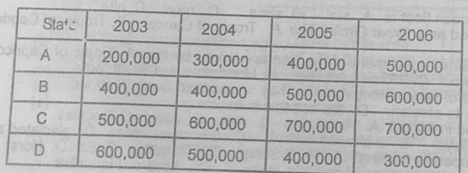
The table below shows the quantity of yams in kilogrammes produced by four yam producing states in country X between 2003 and 2006. State A: 2003 200,000; 2004 300,000; 2005 400,000; 2006 500,000 State B: 2003 400,000; 2004 400,000; 2005 500,000; 2006 600,000 State C: 2003 500,000; 2004 600,000; 2005 700,000; 2006 700,000 State D: 2003 600,000; 2004 500,000; 2005 400,000; 2006 300,000 (a) Draw a comparative / group bar graph to represent the statistics. (b) State two advantages of using comparative / group bar graphs in showing statistics. (c) Name one other method that can be used in showing the statistics.
Show the model answer
Model answer
(a) Title; vertical axis 'Quantity (kg)' with a suitable scale (e.g. 1 cm = 100,000 kg) from 0 to 700,000; horizontal axis with the four states; for each state four touching bars (2003, 2004, 2005, 2006) of correct heights, shaded differently; key to the shading; gaps between groups. (b) Easy to compare years and states at a glance; easy to draw and read; shows trends (A, B, C rising, D falling); actual values can be read off; attractive. (c) Divided (compound) bar graph; line graph; pie charts; proportional circles; table.
Explanation
Keep the same shading for each year in every group.
(a) With the aid of labelled diagrams, describe the instruments used to measure rainfall. (b) Explain how the instruments are used to obtain total annual rainfall. (c) State any two precautions to be taken in the use of the instruments.
Show the model answer
Model answer
(a) Rain gauge: a metal cylinder (about 12.7 cm or 20 cm wide) sunk into the ground with about 30 cm above the surface; a funnel at the top leads rain into a glass bottle/collector inside; a graduated measuring cylinder (in mm) is used to measure the water. Labelled diagram showing funnel, outer case, bottle, ground level and measuring jar. (b) Rain collected is poured into the measuring cylinder and read daily at a fixed time; daily amounts are added to give monthly totals; the 12 monthly totals are added to give the total annual rainfall. (c) Place it in an open space away from trees and buildings (at least twice their height away); top rim about 30 cm above ground to avoid splashing; keep it firmly fixed and level; read at the same time each day; read at eye level; check for leaks and empty after reading; protect from animals.
(a) What is a plateau? (b) List two types of plateaux. (c) Describe the formation of any one type of plateau listed in (b) above. (d) Highlight three ways in which plateaux are of importance to man.
Show the model answer
Model answer
(a) A large, high area of fairly flat land rising steeply above the surrounding land on at least one side (tableland). (b) Tectonic/intermontane plateau (e.g. Tibet), volcanic/lava plateau (e.g. Deccan, Jos partly), dissected plateau, continental plateau (e.g. African plateau), piedmont plateau, erosion plateau. (c) Lava plateau: fissure eruptions pour out runny basic lava over a wide area; layers build up one on another and cool into a high flat surface. Or tectonic: earth movements uplift a large block or land enclosed by fold mountains is raised. (d) Minerals (tin on Jos Plateau, gold); cool climate good for settlement, tourism and some crops/dairy; grazing; source of rivers and HEP sites (waterfalls); forestry; defence.
(a) Define the term soil. (b) Outline three functions of soil. (c) Highlight any two negative effects of man's activities on soil. (d) Describe any two methods of conserving soil.
Show the model answer
Model answer
(a) Soil is the thin loose upper layer of the earth's surface made of weathered rock particles, humus, water, air and living organisms, in which plants grow. (b) Supports plant growth (anchorage, nutrients, water); habitat for organisms; raw material (clay for pottery, bricks); foundation for buildings and roads; filters and stores water; recycles dead matter. (c) Bush burning destroys humus and organisms; deforestation and overgrazing expose soil to erosion; overuse/monocropping exhausts nutrients; pollution by chemicals, oil spills and waste; mining and construction remove topsoil. (d) Contour ploughing/terracing to slow runoff; afforestation and windbreaks; cover cropping and mulching; crop rotation and fallowing; use of manure and fertilizer; controlled grazing.
Write explanatory notes on the following: (a) formation of clouds; (b) relief rainfall.
Show the model answer
Model answer
(a) Moist air rises (by heating, over mountains, or along fronts); it expands and cools adiabatically; when it cools to dew point it becomes saturated; water vapour condenses on tiny particles (condensation nuclei: dust, salt, smoke) into droplets or ice crystals; masses of these form clouds (cirrus, cumulus, stratus, nimbus). (b) Moist wind from the sea meets a mountain barrier and is forced to rise; it cools, condenses and forms clouds; heavy rain falls on the windward side; the air descends the leeward side, warms and becomes dry, giving a rain shadow; e.g. Cameroon Mountain, Jos Plateau. Diagram helpful.
(a) What is water pollution? (b) Highlight any three causes of water pollution. (c) Outline three effects of water pollution. (d) List any two measures that can be used to control water pollution.
Show the model answer
Model answer
(a) Water pollution is the contamination of water bodies by harmful substances that make the water unfit for use or harmful to living things. (b) Dumping of domestic sewage and refuse; industrial effluents; oil spills; runoff of fertilizers and pesticides; mining wastes; acid rain; hot water from power stations. (c) Death of fish and other aquatic life; water-borne diseases (cholera, typhoid); growth of algae and weeds that block waterways; water unfit for drinking and industry; loss of fishing jobs; loss of recreation and tourism. (d) Laws and penalties against dumping; treatment of sewage and industrial waste; public enlightenment; proper waste disposal facilities; careful use of farm chemicals; cleaning up oil spills.
Write explanatory notes on drought under the following: (a) causes; (b) effects; (c) control.
Show the model answer
Model answer
Drought is a long period with little or no rain, leading to water shortage. (a) Causes: failure or late onset of rains (shift of the ITD); high temperatures and evaporation; low humidity and little cloud; deforestation and desertification; climate change; overgrazing. (b) Effects: crop failure and famine; death of livestock; drying of rivers, wells and lakes; migration of people and animals; malnutrition and disease; desertification; conflicts between farmers and herders; loss of income. (c) Control: irrigation and dams to store water; afforestation and shelter belts; drought-resistant crops; controlled grazing; water conservation; cloud seeding; early warning and education.