WAEC Geography 2006 past questions and answers

63 questions. Try each one, then open the answer to check yourself and read the explanation.

Question 1

Map Scale, Distance and Direction

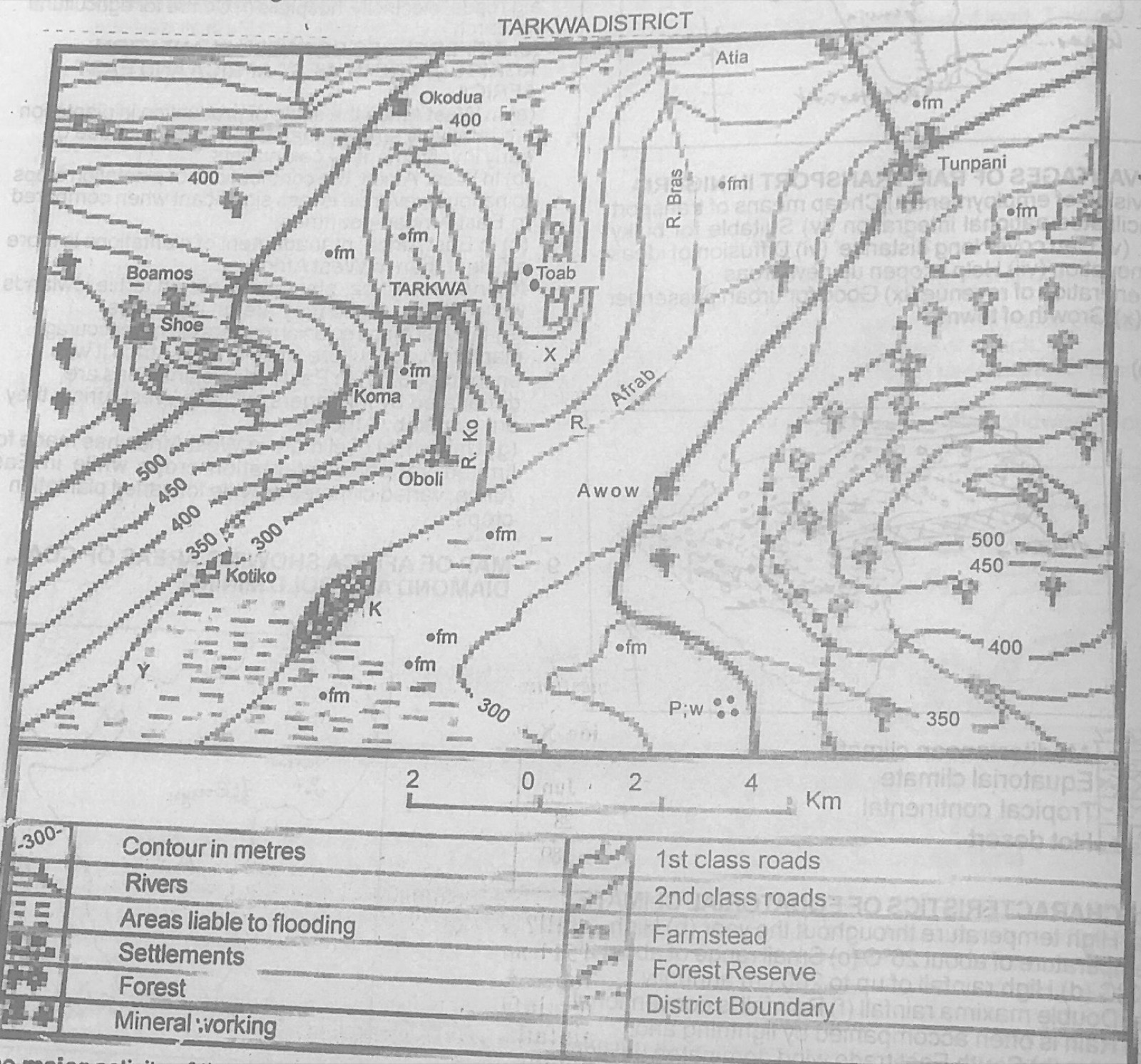
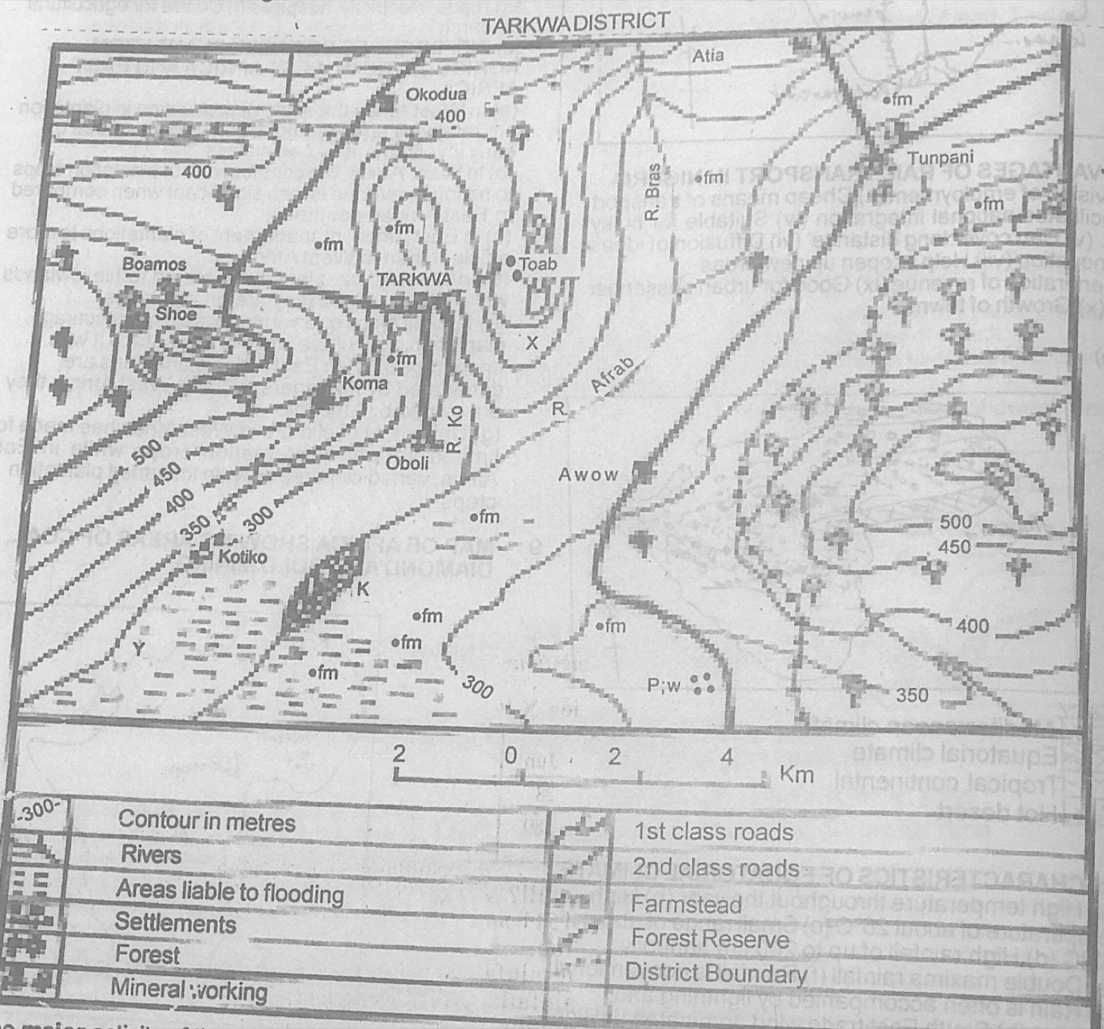
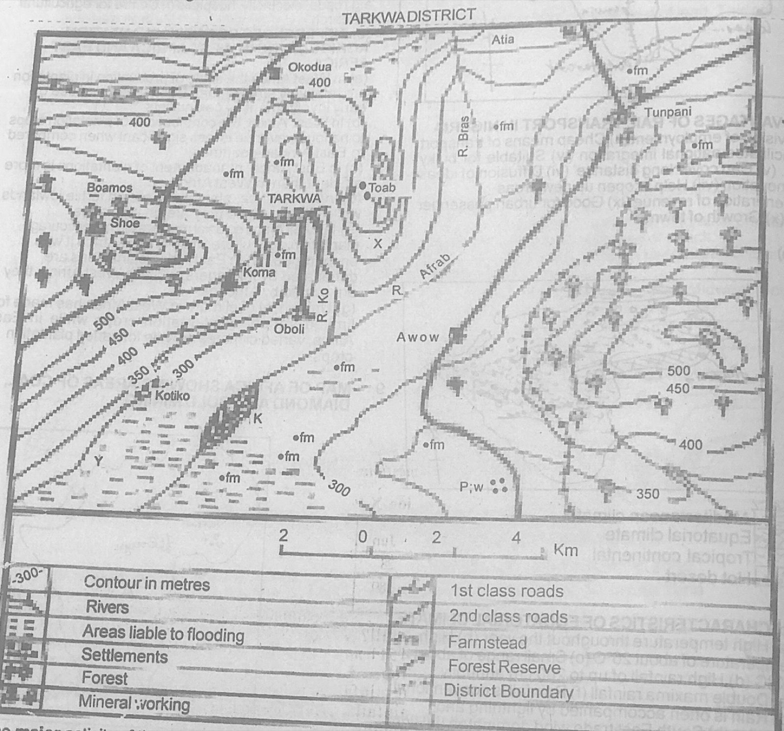
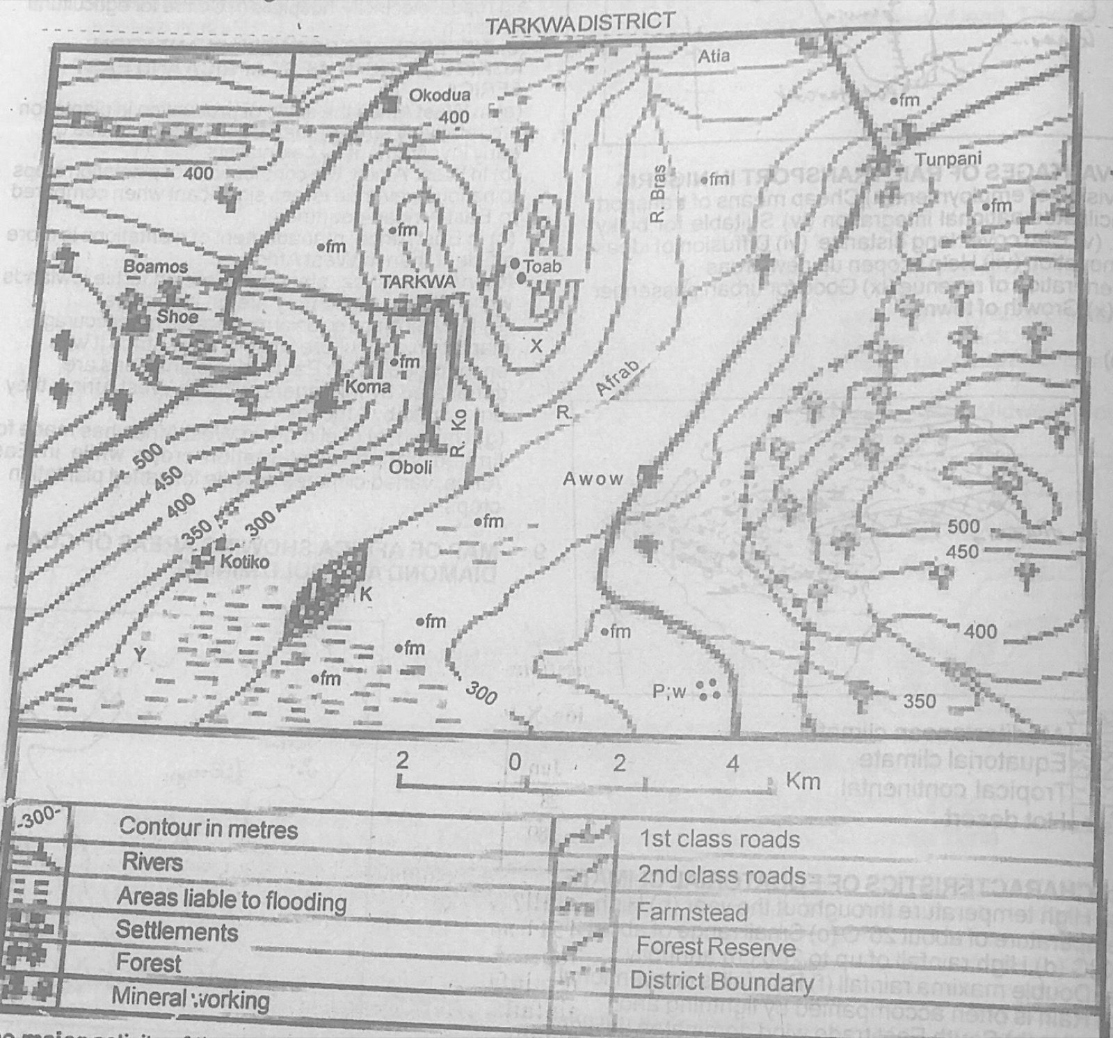
Study the map of TARKWA DISTRICT to answer this question. What is the approximate distance by road between Toab and Oboli?

Diagram for this question
  1. A.4.0 kilometres
  2. B.5.0 kilometres
  3. C.6.0 kilometres
  4. D.7.0 kilometres
Show the answer and explanation

Answer: B (5.0 kilometres)

Explanation

Follow the road from Toab to Oboli with a strip of paper and lay it on the linear scale: about 5 km.

Open this question

Question 2

Map Scale, Distance and Direction

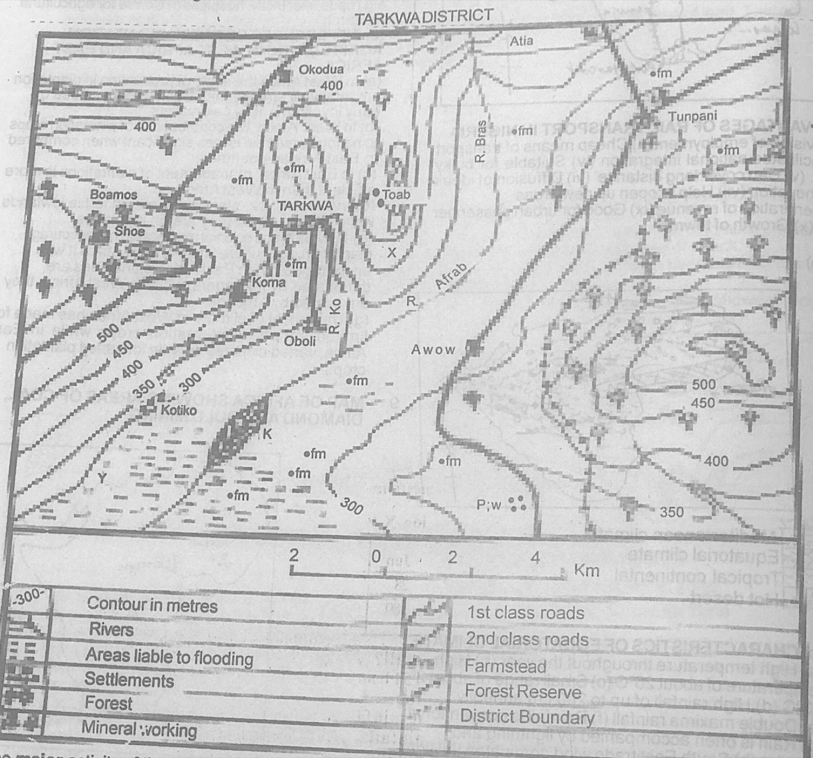
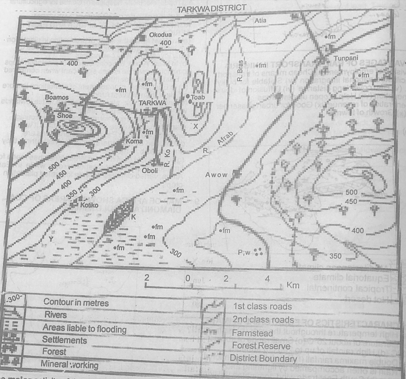
Study the map of TARKWA DISTRICT to answer this question. The angular bearing of Shoe from Oboli is approximately

Diagram for this question
  1. A.300°
  2. B.243°
  3. C.207°
  4. D.27°
Show the answer and explanation

Answer: A (300°)

Explanation

Shoe lies west-north-west of Oboli, so its bearing is a little more than 270°: about 300°.

Open this question

Question 3

Relief and Map Interpretation

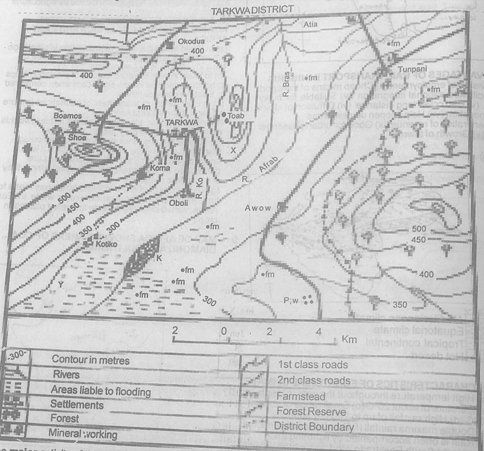
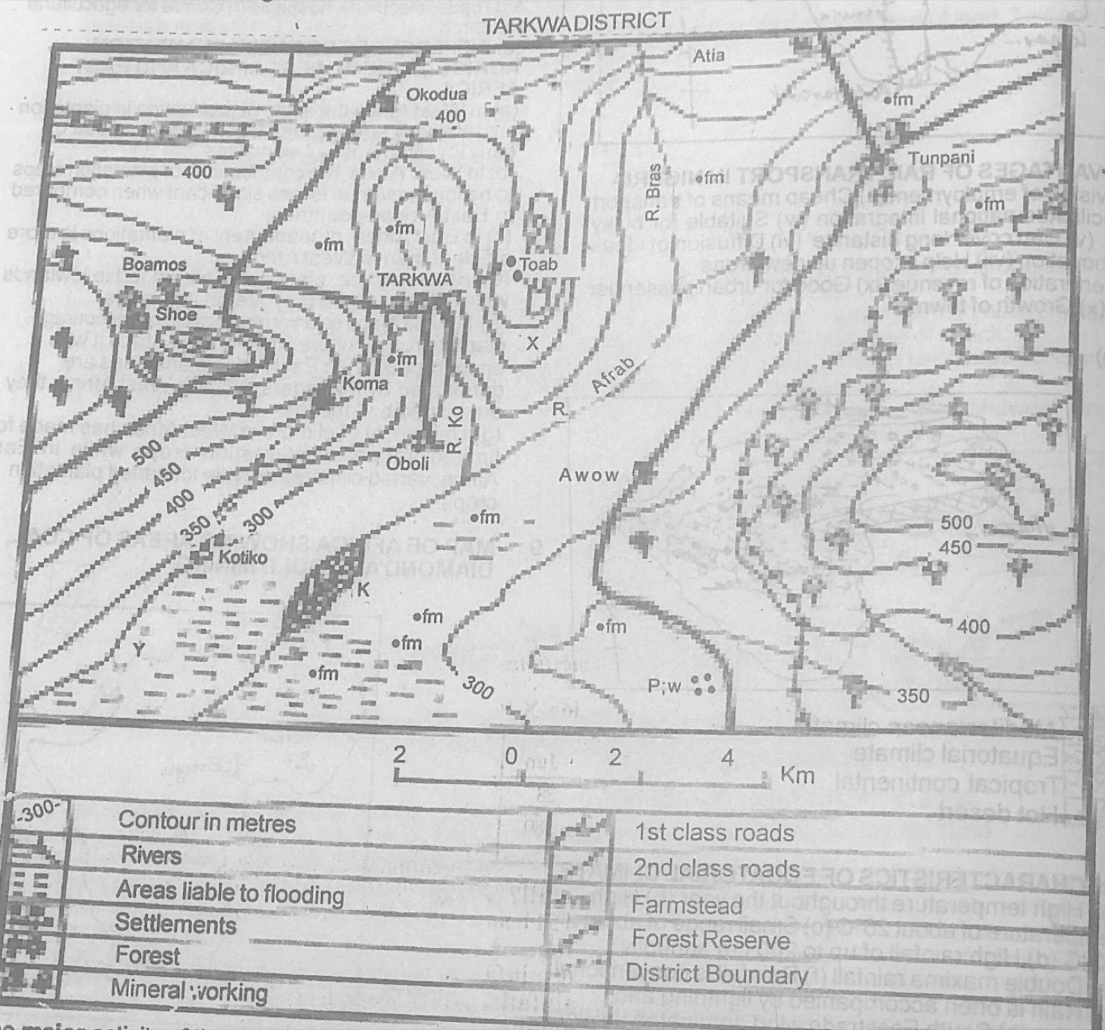
Study the map of TARKWA DISTRICT to answer this question. Which of the following settlements is not visible from Koma?

Diagram for this question
  1. A.Tarkwa
  2. B.Oboli
  3. C.Shoe
  4. D.Awow
Show the answer and explanation

Answer: C (Shoe)

Explanation

The hill with closed contours west of Koma stands between Koma and Shoe and blocks the view.

Open this question

Question 4

Relief and Map Interpretation

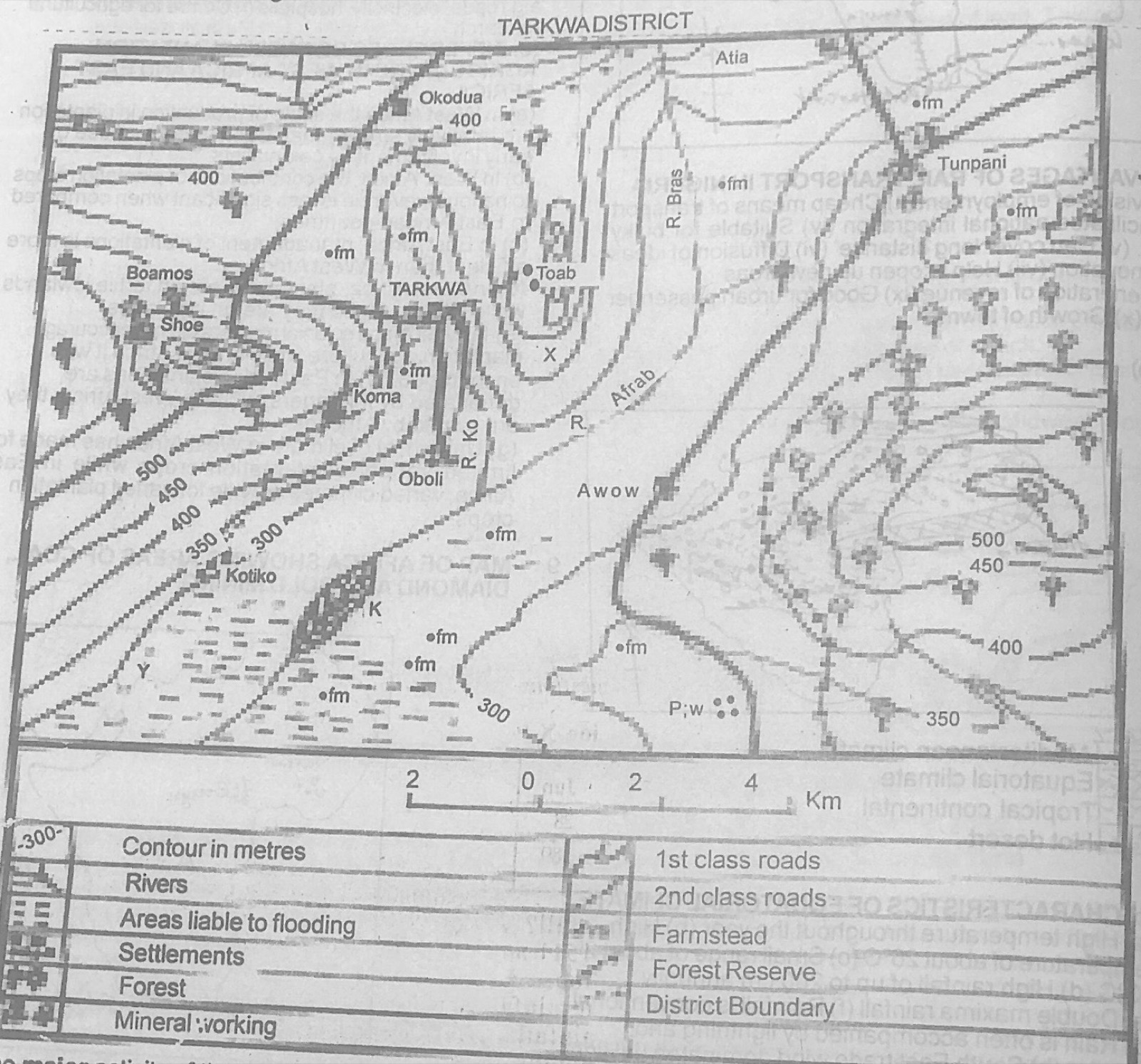
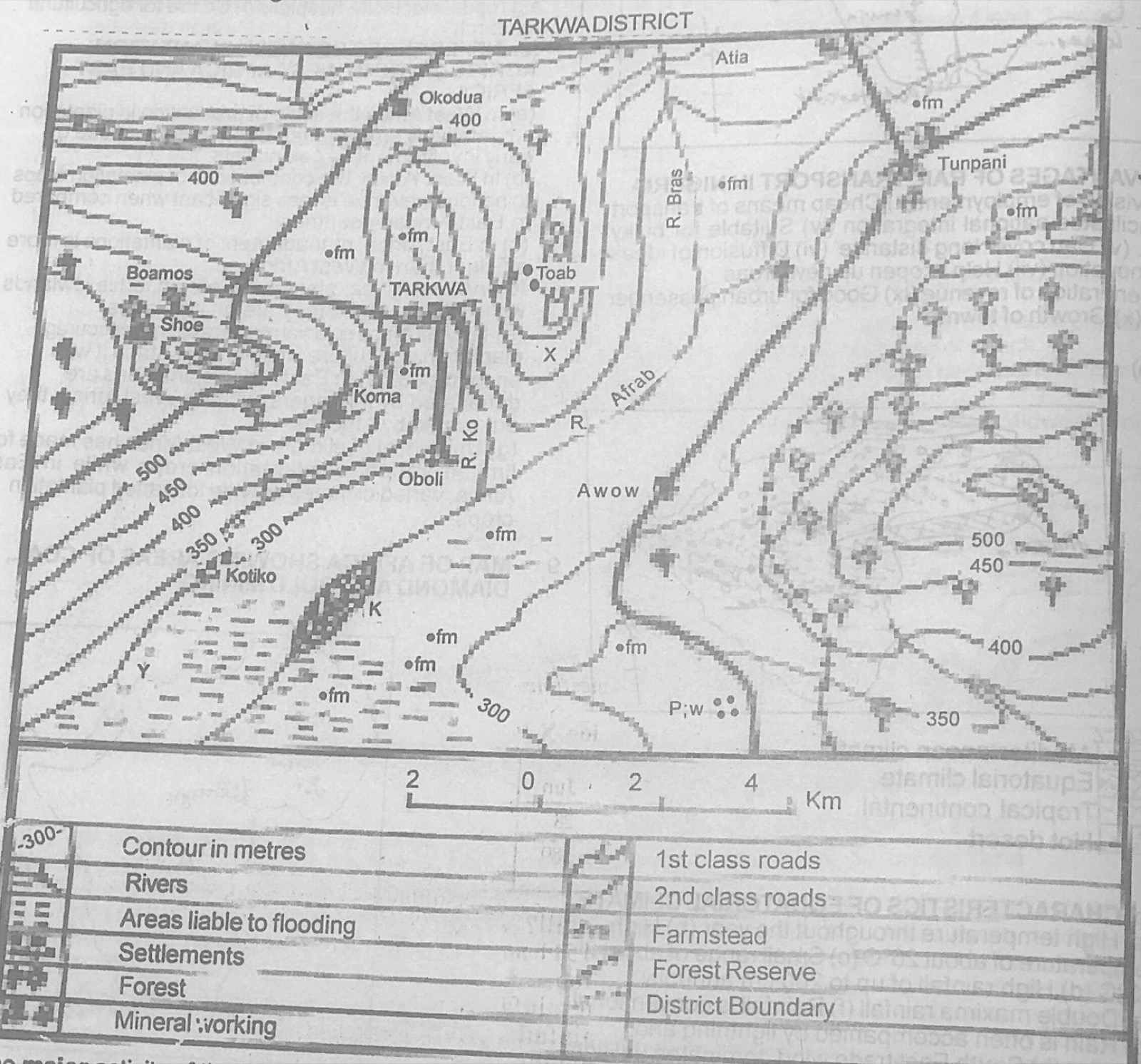
Study the map of TARKWA DISTRICT to answer this question. The major activity of the people in Shoe is likely to be

Diagram for this question
  1. A.mining
  2. B.farming
  3. C.lumbering
  4. D.fishing.
Show the answer and explanation

Answer: C (lumbering)

Explanation

Forest symbols surround Shoe and Boamos in the west, so lumbering is likely.

Open this question

Question 5

Relief and Map Interpretation

Study the map of TARKWA DISTRICT to answer this question. Which of the following crops can be successfully cultivated around Y?

Diagram for this question
  1. A.Millet
  2. B.Wheat
  3. C.Coffee
  4. D.Rice
Show the answer and explanation

Answer: D (Rice)

Explanation

Y is in the area liable to flooding, which suits rice.

Open this question

Question 6

Relief and Map Interpretation

Study the map of TARKWA DISTRICT to answer this question. Tunpani is important for

Diagram for this question
  1. A.rice cultivation
  2. B.mining
  3. C.lumbering
  4. D.cattle rearing
Show the answer and explanation

Answer: B (mining)

Explanation

A mineral working symbol is printed at Tunpani.

Open this question

Question 7

Relief and Map Interpretation

Study the map of TARKWA DISTRICT to answer this question. There are few settlements to the east because of the

Diagram for this question
  1. A.absence of roads
  2. B.presence of a forest reserve
  3. C.absence of water resources
  4. D.predominance of rugged landscape
Show the answer and explanation

Answer: B (presence of a forest reserve)

Explanation

The east is covered by a forest reserve, where settlement is not allowed.

Open this question

Question 8

Relief and Map Interpretation

Study the map of TARKWA DISTRICT to answer this question. The feature marked X is a

Diagram for this question
  1. A.spur
  2. B.ridge
  3. C.cliff
  4. D.plateau
Show the answer and explanation

Answer: A (spur)

Explanation

At X the contours form a tongue pointing downhill from the hill near Toab: a spur.

Open this question

Question 9

Map Scale, Distance and Direction

Study the map of TARKWA DISTRICT to answer this question. The area covered by the map is approximately

Diagram for this question
  1. A.294 km²
  2. B.256 km²
  3. C.190 km²
  4. D.180 km²
Show the answer and explanation

Answer: B (256 km²)

Explanation

Measure the length and width of the map frame on the linear scale and multiply them.

Open this question

Question 10

Map Scale, Distance and Direction

Study the map of TARKWA DISTRICT to answer this question. The distance between Tunpani and Awow 'as the crow flies' is

Diagram for this question
  1. A.2.50 km
  2. B.4.25 km
  3. C.6.45 km
  4. D.8.25 km
Show the answer and explanation

Answer: D (8.25 km)

Explanation

Measure the straight line from Tunpani (north-east) to Awow and compare it with the linear scale: about 8 km.

Open this question

Question 11

The Earth and Solar System

The farthest planet from the sun in the solar system is the

  1. A.Mercury
  2. B.Earth
  3. C.Saturn
  4. D.Pluto
Show the answer and explanation

Answer: D (Pluto)

Explanation

Pluto (then counted as a planet) orbits farthest from the sun.

Open this question

Question 12

The Earth and Solar System

Which of the following is not a proof to show that the earth is spherical in shape?

  1. A.Sunrise and sunset
  2. B.Aerial photograph
  3. C.Lunar eclipse
  4. D.Twilight and dawn
Show the answer and explanation

Answer: D (Twilight and dawn)

Explanation

Twilight and dawn come from sunlight scattered by the atmosphere, not from the earth's round shape.

Open this question

Question 13

Latitude, Longitude and Time

Latitude 66½°S marks the

  1. A.Antarctic circle
  2. B.Arctic circle
  3. C.Tropic of Cancer
  4. D.Tropic of Capricorn
Show the answer and explanation

Answer: A (Antarctic circle)

Explanation

66½°S is the Antarctic Circle; 66½°N is the Arctic Circle.

Open this question

Question 14

Latitude, Longitude and Time

What is the distance along a great circle between Latitudes 27°S and 23.5°N of the equator?

  1. A.5,705.5 km
  2. B.5,610.5 km
  3. C.5,500.5 km
  4. D.5,405.5 km
Show the answer and explanation

Answer: B (5,610.5 km)

Explanation

The places are on opposite sides of the equator: 27 + 23.5 = 50.5°; 50.5 × 111.1 km ≈ 5,610.5 km.

Open this question

Question 15

Weather

The direction of wind is recorded by an instrument called

  1. A.anemometer
  2. B.wind vane
  3. C.hygrometer
  4. D.barometer
Show the answer and explanation

Answer: B (wind vane)

Explanation

A wind vane points to the direction from which the wind blows.

Open this question

Question 16

Weather

Diurnal range of temperature is obtained by

  1. A.adding all temperature readings for the day
  2. B.adding all temperature readings for the month
  3. C.subtracting the minimum temperature of the day from the maximum temperature of the same day
  4. D.subtracting the minimum temperature for the month from the maximum temperature for the same month
Show the answer and explanation

Answer: C (subtracting the minimum temperature of the day from the maximum temperature of the same day)

Explanation

Diurnal (daily) range = day's maximum − day's minimum.

Open this question

Question 17

Climate

Koppen's climatic classification was based on

  1. A.rainfall only
  2. B.the longitude of a place
  3. C.both rainfall and temperature
  4. D.the latitude of a place
Show the answer and explanation

Answer: C (both rainfall and temperature)

Explanation

Koppen used mean temperature and rainfall values (linked to vegetation).

Open this question

Question 18

Weather

The dust particles over which moisture settles when condensation takes place is known as

  1. A.atmospheric nuclei
  2. B.hydrocarbon
  3. C.smoke
  4. D.nitrogen
Show the answer and explanation

Answer: A (atmospheric nuclei)

Explanation

Water vapour condenses on tiny particles of dust, salt and smoke called condensation (atmospheric) nuclei.

Open this question

Question 19

Rocks

An example of organically formed sedimentary rock is

  1. A.sandstone
  2. B.rock salt
  3. C.grit
  4. D.limestone
Show the answer and explanation

Answer: D (limestone)

Explanation

Limestone forms from shells and skeletons of sea creatures; rock salt is chemically formed, sandstone and grit mechanically.

Open this question

Question 20

Rivers and River Landforms

A river transports its load through the following processes except

  1. A.solution
  2. B.suspension
  3. C.traction
  4. D.plucking
Show the answer and explanation

Answer: D (plucking)

Explanation

Plucking is glacial erosion, not a way a river carries load.

Open this question

Question 21

Oceans and Lakes

The difference between high tide and low tide is referred to as

  1. A.tidal gauge
  2. B.tidal height
  3. C.tidal range
  4. D.tidal flow
Show the answer and explanation

Answer: C (tidal range)

Explanation

Tidal range is the height difference between high and low water.

Open this question

Question 22

Rivers and River Landforms

All the following are found in the upper course of a river except

  1. A.v-shaped valleys
  2. B.ox-bow lakes
  3. C.interlocking spurs
  4. D.waterfalls
Show the answer and explanation

Answer: B (ox-bow lakes)

Explanation

Ox-bow lakes form from meanders on flood plains in the lower course.

Open this question

Question 23

Soils

The typical red tropical soil is

  1. A.deeply weathered in nature, with marked A horizon and little humus
  2. B.rich in humus, with healthy overhead vegetation and high temperature
  3. C.deeply weathered in nature and rich in humus
  4. D.rich in humus with high temperature
Show the answer and explanation

Answer: A (deeply weathered in nature, with marked A horizon and little humus)

Explanation

Tropical red (lateritic) soils are deeply weathered and heavily leached, so they contain little humus.

Open this question

Question 24

Rivers and River Landforms

Plung pool is a feature of

  1. A.river meanders
  2. B.interlocking spurs
  3. C.waterfalls
  4. D.water rapids
Show the answer and explanation

Answer: C (waterfalls)

Explanation

Falling water and boulders scour a deep plunge pool at the foot of a waterfall.

Open this question

Question 25

Earth Movements and Vulcanicity

All the following are examples of intrusive volcanic features except

  1. A.dykes
  2. B.sills
  3. C.lava plateaux
  4. D.batholiths
Show the answer and explanation

Answer: C (lava plateaux)

Explanation

Lava plateaux form on the surface (extrusive); the others cool underground.

Open this question

Question 26

Rocks

The formation of metamorphic rocks normally involves the change of other rocks through

  1. A.solution
  2. B.heat
  3. C.folding
  4. D.tension
Show the answer and explanation

Answer: B (heat)

Explanation

Great heat (and pressure) changes existing rocks into metamorphic rocks.

Open this question

Question 27

Rocks

Which of the following rocks is used for fuel?

  1. A.Lignite
  2. B.Granite
  3. C.Diorite
  4. D.Mica
Show the answer and explanation

Answer: A (Lignite)

Explanation

Lignite is brown coal, burnt as fuel.

Open this question

Question 28

Underground Water and Karst

A basin where rock layers have been down folded and in which permeable rock which has trapped water is sandwiched between impermeable layers is referred to as

  1. A.drainage basin
  2. B.river basin
  3. C.water basin
  4. D.artesian basin
Show the answer and explanation

Answer: D (artesian basin)

Explanation

This describes an artesian basin, where water is held under pressure.

Open this question

Question 29

Earth Movements and Vulcanicity

Which of the following mountains is not a fold mountain?

  1. A.The Atlas
  2. B.The Andes
  3. C.The Vosges
  4. D.The Himalayas
Show the answer and explanation

Answer: C (The Vosges)

Explanation

The Vosges are block mountains (a horst); the others are fold mountains.

Open this question

Question 30

Wind and Desert Landforms

All the following are features produced by wind erosion except

  1. A.rock pedestals
  2. B.zeugens
  3. C.rift valleys
  4. D.yardangs
Show the answer and explanation

Answer: C (rift valleys)

Explanation

Rift valleys are formed by faulting, not by wind.

Open this question

Question 31

Agriculture, Fishing and Lumbering

The mediterranean type of climate is best favoured for

  1. A.yam cultivation
  2. B.fruit growing
  3. C.cotton cultivation
  4. D.wheat production
Show the answer and explanation

Answer: B (fruit growing)

Explanation

Hot sunny dry summers suit citrus, grapes and olives.

Open this question

Question 32

Weather

Which of the following is a north-easterly wind from the Sahara blowing towards the Gulf of Guinea?

  1. A.The Sirocco
  2. B.The Fohn
  3. C.The Harmattan
  4. D.The Chinook
Show the answer and explanation

Answer: C (The Harmattan)

Explanation

The harmattan is the dry dusty north-east trade wind from the Sahara.

Open this question

Question 33

Oceans and Lakes

Continental shelves are important for all the following except

  1. A.fishing
  2. B.sea piracy
  3. C.development of harbour
  4. D.recreation
Show the answer and explanation

Answer: B (sea piracy)

Explanation

Sea piracy is a crime, not a use of the continental shelf.

Open this question

Question 34

Coastal Landforms

Spits and bars are formed by

  1. A.river erosion
  2. B.wind deposition
  3. C.wave erosion
  4. D.wave deposition
Show the answer and explanation

Answer: D (wave deposition)

Explanation

Waves and longshore drift deposit sand to build spits and bars.

Open this question

Question 35

Environmental Hazards and Conservation

All the following constitute environmental hazards except

  1. A.urbanization
  2. B.mass wasting
  3. C.earthquakes
  4. D.drought
Show the answer and explanation

Answer: A (urbanization)

Explanation

Urbanization is a process of town growth, not a hazard event in itself.

Open this question

Question 36

Vegetation

The Equatorial forests of the Amazon basin is generally referred to as the

  1. A.Campos
  2. B.Selvas
  3. C.Pampas
  4. D.Llanos
Show the answer and explanation

Answer: B (Selvas)

Explanation

The Amazon rain forest is called the selvas; campos and llanos are savannas, pampas are grasslands.

Open this question

Question 37

Vegetation

Xerophytic plants are usually associated with

  1. A.regions of heavy rainfall
  2. B.waterlogging
  3. C.areas of low rainfall
  4. D.windward part of a highland
Show the answer and explanation

Answer: C (areas of low rainfall)

Explanation

Xerophytes are plants adapted to drought.

Open this question

Question 41

Settlement

"Houses are far apart from one another. They are commonly connected by foot path". This description refers to

  1. A.ribbon settlement
  2. B.dispersed settlement
  3. C.nucleated settlement
  4. D.urban settlement
Show the answer and explanation

Answer: B (dispersed settlement)

Explanation

Scattered houses linked by footpaths form a dispersed settlement.

Open this question

Question 42

Transport, Trade and Tourism

Ports that specialize in receiving and redistributing goods to neighbouring countries are called

  1. A.river ports
  2. B.entrepots:
  3. C.outports
  4. D.inland ports
Show the answer and explanation

Answer: B (entrepots:)

Explanation

An entrepôt port re-exports goods to other countries (e.g. Singapore, Rotterdam).

Open this question

Question 43

Population

An area is said to be over-populated if

  1. A.there is not enough food to cater for the population
  2. B.its inhabitants are not using birth control methods
  3. C.it has more people than its developed physical and human resources can support
  4. D.there is massive rural-urban migration
Show the answer and explanation

Answer: C (it has more people than its developed physical and human resources can support)

Explanation

Over-population means too many people for the developed resources, so living standards fall.

Open this question

Question 44

Agriculture, Fishing and Lumbering

The greatest problem associated with cattle rearing in West Africa is

  1. A.inadequate capital
  2. B.the absence of high quality cattle
  3. C.insufficient market
  4. D.the presence of tse-tse fly
Show the answer and explanation

Answer: D (the presence of tse-tse fly)

Explanation

Tsetse flies spread sleeping sickness (trypanosomiasis), keeping cattle out of the wetter south.

Open this question

Question 45

Transport, Trade and Tourism

Which of the following is a major benefit of international trade?

  1. A.Total dependence on other countries for essential goods
  2. B.Revenue generation
  3. C.Stabilization of prices
  4. D.Free movement of people across borders
Show the answer and explanation

Answer: B (Revenue generation)

Explanation

Governments earn revenue (duties, foreign exchange) from international trade.

Open this question

Question 46

Transport, Trade and Tourism

Perishable goods; items of high unit value (gold, diamond) are best transported by

  1. A.road
  2. B.rail
  3. C.air
  4. D.sea
Show the answer and explanation

Answer: C (air)

Explanation

Air is fastest and safest, so it suits perishable and valuable goods.

Open this question

Question 47

Settlement

One of the functions performed by rural settlements for urban settlements is the provision of

  1. A.employment
  2. B.agricultural products
  3. C.manufactured goods
  4. D.ideas and innovations
Show the answer and explanation

Answer: B (agricultural products)

Explanation

Villages supply food and raw materials to towns.

Open this question

Question 48

Transport, Trade and Tourism

Which of the following is not a contribution of land transport to the economic development of any country?

  1. A.Generation of income
  2. B.Employment opportunities
  3. C.Depopulation of urban centres
  4. D.Diffusion of ideas and innovations.
Show the answer and explanation

Answer: C (Depopulation of urban centres)

Explanation

Transport does not empty towns; it usually helps them grow.

Open this question

Question 49

Geography of Africa

Which of these African countries is noted for lumbering?

  1. A.Chad
  2. B.Uganda
  3. C.Zaire (Now Democratic Republic of Congo (DRC)
  4. D.Kenya
Show the answer and explanation

Answer: C (Zaire (Now Democratic Republic of Congo (DRC))

Explanation

The DR Congo has vast equatorial forests.

Open this question

Question 50

Population

The major causes of change in population size are

  1. A.births, deaths and migration
  2. B.births, marriage and deaths
  3. C.births, accidents and deaths
  4. D.migration, fertility and marriage
Show the answer and explanation

Answer: A (births, deaths and migration)

Explanation

Population grows by births and immigration and falls by deaths and emigration.

Open this question

Theory question 101

Transport, Trade and Tourism

(a) What is Transportation? (b) Highlight four advantages of air transportation (c) Describe five contributions of transportation to economic development

Show the model answer
Model answer

(a) Transportation is the movement of people, goods and services from one place to another.
(b) Fastest mode; comfortable; uses direct routes not blocked by mountains, seas or forests; reaches remote areas with airstrips; carries perishable and valuable goods; useful in emergencies (relief, medical supplies); no route construction needed apart from airports.
(c) Moves goods and raw materials to factories and markets; carries people to work and places; creates employment; opens up new areas for development; promotes trade (internal and international); earns revenue and foreign exchange; promotes tourism; national integration and spread of ideas.

Explanation

Each contribution should name what moves and why it helps the economy.

Open this question

Theory question 102

Transport, Trade and Tourism

(a) Give five reasons why your country has more trading partners outside Africa. (b) Outline any five ways by which the trade between your country and other African countries could be improved

Show the model answer
Model answer

(a) African countries produce similar primary goods; Nigeria needs manufactured goods and machinery from industrial countries; poor transport links within Africa; colonial ties with Britain and Europe; different currencies and trade barriers in Africa; foreign countries have strong currencies and buying power; preference for foreign goods; political instability in some African countries.
(b) Diversify and specialise production; remove tariffs and trade barriers (ECOWAS, African Union); build trans-African roads and railways; adopt a common currency; promote common languages; protect and patronise African goods; improve technology and add value to exports; political stability.

Explanation

Link reasons to the type of goods produced in Africa.

Open this question

Theory question 103

Manufacturing Industry

(a) Outline any four advantages of concentration of industries in urban areas. (b) Highlight any three disadvantages of concentration of industries in urban areas. (c) Describe three factors responsible for the dominance of light industries in the developing countries

Show the model answer
Model answer

(a) Available skilled and unskilled labour; large market nearby; good transport and communication; power, water and other infrastructure; linkage between industries (sharing inputs and services); banks and insurance; job creation for town dwellers.
(b) Pollution of air, water and land; congestion and overcrowding; slums and housing problems; high cost of land and rent; rural-urban migration; unemployment and crime; strain on social amenities.
(c) Low capital requirement; simple technology and little skill needed; large local market for consumer goods; use of local agricultural raw materials; quick returns on investment; limited power supply suits light industries; government incentives for small industries.

Explanation

Separate the benefits of clustering from its problems.

Open this question

Theory question 104

Nigeria: People and Economy

For candidates in Nigeria: (a) Draw an outline map of Nigeria. On the map, show and name: (i) one area important for oil palm production; (ii) one area important for cattle rearing; (iii) one town in the oil palm producing area; (iv) two towns in the cattle rearing area (b) Outline any three factors that favour cattle rearing in the area shown in 4(a)(ii) above. (c) Highlight any three ways in which cattle rearing is of importance to Nigeria

Show the model answer
Model answer

(a) Oil palm: south-east and mid-west (Imo, Abia, Akwa Ibom, Cross River, Edo, Delta), town e.g. Umuahia, Owerri, Calabar, Benin; cattle: northern savanna (Sokoto, Kano, Katsina, Borno, Bauchi), towns e.g. Sokoto, Kano, Maiduguri, Potiskum.
(b) Absence of tsetse fly in the drier north; extensive grassland pasture; long dry season keeps disease low; nomadic Fulani with herding skill; large market in the south; water from rivers, Lake Chad and boreholes; availability of land.
(c) Meat and milk (protein); hides and skins for leather industries; income for farmers; government revenue (jangali/cattle tax); employment for herders, butchers and traders; manure for farms; draught animals; trade within Nigeria.

Explanation

Name two towns inside the cattle area as asked.

Open this question

Theory question 105

Nigeria: Physical Setting

For candidates in Nigeria: (a) Draw an outline map of Nigeria. On the map, show and name: (i) Lake Kainji; (ii) one area with extinct volcano; (iii) the Udi hills; (iv) the River Hadeija (b) Highlight any four problems of development in the Eastern Borderland (c) Outline two solutions to any of the problems highlighted in 5(b) above

Show the model answer
Model answer

(a) Lake Kainji on the Niger in Niger State (north-west of Jebba); extinct volcanoes on the Jos Plateau (around Jos/Vom) or the Biu Plateau; Udi Hills near Enugu; River Hadejia in Kano/Jigawa flowing east to join the Yobe.
(b) Rugged relief and steep slopes; poor transport and remoteness; soil erosion; no major mineral resources; poor pasture; scanty rainfall in the north; few industries and lack of capital; insecurity along the border; low population in some parts.
(c) Build roads and bridges; soil conservation and afforestation; develop tourism (Obudu ranch, Mambilla); improve pastures and ranching (Mambilla, Obudu); irrigation; provide social amenities to attract investment.

Explanation

Place the Eastern Borderland along the Cameroon border.

Open this question

Theory question 106

Nigeria: People and Economy

For candidates in Nigeria: (a) Draw an outline map of Nigeria. On the map, show and name; (i) one area of sparse population; (ii) one area of moderate population; (iii) one area of dense population; (iv) one town in 6(a)(i) above (b) Outline three factors responsible for the dense population in the area shown in 6(a)(iii) above. (c) Highlight three problems of dense population in 6(a)(iii) above.

Show the model answer
Model answer

(a) Sparse: Middle Belt (Niger, Kwara, Kogi, Taraba) or north-east desert edge, town e.g. Bida, Ilorin, Jalingo; moderate: parts of the south-west or north-central (Oyo, Plateau, Kaduna); dense: Lagos area, south-east (Onitsha-Owerri-Aba) or Kano close-settled zone.
(b) Fertile soils and long farming season; commercial and industrial activities providing jobs; ports and administrative centres; good transport and social amenities; historical factors (old kingdoms, security); absence of tsetse fly (Kano).
(c) Pressure on land and soil exhaustion; housing shortage and slums; unemployment and crime; traffic congestion; pollution and poor sanitation; pressure on social amenities; spread of diseases.

Explanation

Use a key with three density classes.

Open this question

Theory question 107

Geography of Africa

(a) Draw a sketch map of Africa. On the map, show and name the (i) River Nile; (ii) River Niger; (iii) River Orange (iv) River Zambezi (b) Describe four characteristics of African rivers (c) Highlight three uses of African rivers

Show the model answer
Model answer

(a) Nile from Lake Victoria (and Ethiopian highlands) north to the Mediterranean; Niger from the Fouta Djallon, curving north-east through Mali then south-east through Niger and Nigeria to the Gulf of Guinea; Orange from Lesotho west to the Atlantic between South Africa and Namibia; Zambezi from Zambia/Angola east through Victoria Falls and Kariba to the Indian Ocean in Mozambique.
(b) Many have rapids, cataracts and waterfalls because they cross plateau edges; seasonal flow (high water in the rainy season, low in the dry season); some flow through deserts (Nile, Niger) and lose water by evaporation; many have deltas or sandbars at their mouths; some have inland drainage (into Lake Chad); long courses with large basins.
(c) Water for irrigation and domestic use; hydro-electric power (Kainji, Kariba, Aswan, Akosombo); fishing; transport; tourism; boundaries between countries.

Explanation

Show source and mouth of each river correctly.

Open this question

Theory question 108

Geography of Africa

(a) Draw an outline map of Africa. On the map, show and name (i) one area that receives rainfall in winter; (ii) the dominant air masses over Africa in July; (iii) the position of the ITCZ in July (b) Explain the effects of altitude on the climate of Africa.

Show the model answer
Model answer

(a) Winter rainfall: north-west Africa (Mediterranean coast of Morocco, Algeria, Tunisia) or the south-west Cape; July air masses: tropical maritime (south-west monsoon) over West Africa from the Atlantic, tropical continental over the Sahara, south-east trades over southern Africa; ITCZ in July at about 20°N across the Sahara/Sahel.
(b) Temperature falls with height (about 6°C per 1,000 m), so highlands like the East African plateau, Jos Plateau and Ethiopia are cooler than lowlands at the same latitude; highlands receive more orographic rain on windward slopes, with rain shadows on leeward sides; mountain tops (Kilimanjaro, Kenya) have snow; lower pressure and thinner air; highland climates support temperate crops and European settlement.

Explanation

Show the ITCZ well north of the equator in July.

Open this question

Theory question 109

West Africa and ECOWAS

(a) Draw a sketch map of West Africa. On the map, locate and name; (i) one English speaking country; (ii) one French speaking country; (iii) one Portuguese speaking country; (iv) the capital cities of any two in (a)(i) – (iii). (b) Highlight three achievements of ECOWAS since inception. (c) Outline two problems working against the achievement of the objectives of ECOWAS

Show the model answer
Model answer

(a) English: Nigeria (Abuja), Ghana (Accra), Sierra Leone (Freetown), Liberia (Monrovia), The Gambia (Banjul); French: Senegal (Dakar), Mali (Bamako), Niger (Niamey), Côte d'Ivoire, Togo (Lomé), Benin (Porto-Novo), Burkina Faso (Ouagadougou), Guinea (Conakry); Portuguese: Guinea-Bissau (Bissau), Cape Verde (Praia).
(b) Free movement of people (ECOWAS passport, visa-free travel); peace-keeping through ECOMOG (Liberia, Sierra Leone); trade liberalisation scheme; regional road projects (Trans-West African highway); ECOWAS Bank; cultural and sports exchanges; West African gas pipeline.
(c) Different currencies; language differences; political instability and coups; similar products; poor transport links; members' ties to other unions and former colonial powers; non-payment of dues.

Explanation

Use a key to separate the three language groups.

Open this question

Theory question 202

Statistical Maps and Diagrams

Use TABLE II below and the attached map A for Nigeria to answer the questions that follow.
TABLE II: Volume of Rail Passenger Traffic Generated by Five Nigerian cities, 1973
Ibadan: 5,000,000
Enugu: 3,000,000
Maiduguri: 2,500,000
Port Harcourt: 1,500,000
Minna: 1,000,000
(a) Represent the statistics with proportional circles. (b) Outline two advantages of representing data with proportional symbols.

Show the model answer
Model answer

(a) Radius proportional to the square root of each value: √5,000,000 ≈ 2,236; √3,000,000 ≈ 1,732; √2,500,000 ≈ 1,581; √1,500,000 ≈ 1,225; √1,000,000 = 1,000. Choose a scale, e.g. 1 cm = 1,000 units of square root: radii Ibadan 2.2 cm, Enugu 1.7 cm, Maiduguri 1.6 cm, Port Harcourt 1.2 cm, Minna 1.0 cm; draw each circle centred on its city on the map of Nigeria, with title, key and scale.
(b) Gives a clear visual impression and easy comparison of quantities; shows the location (distribution) of the data on a map at the same time; a wide range of values can be shown in a small space; attractive and easy to understand.

Explanation

Use square roots of the values so that circle areas, not radii, match the data.

Open this question

Theory question 203

The Earth and Solar System

(a) Describe the solar system. (b) Outline four characteristics each of the following planets: (i) Pluto; (ii) Mercury

Show the model answer
Model answer

(a) The solar system is the sun and all the bodies that revolve round it: the planets (Mercury, Venus, Earth, Mars, Jupiter, Saturn, Uranus, Neptune and Pluto as counted then) in elliptical orbits, their moons, asteroids (mostly between Mars and Jupiter), comets and meteors; the sun at the centre provides light and heat; planets shine by reflected light; all held by the sun's gravity.
(b)(i) Pluto: farthest from the sun (about 5,900 million km); smallest (about 2,300 km diameter); very cold (about −230°C); longest revolution (about 248 years); has a moon (Charon); highly elliptical orbit; now classed as a dwarf planet.
(ii) Mercury: nearest the sun (about 58 million km); small (about 4,880 km diameter); shortest revolution (88 days); rotates slowly (about 59 days); very hot on the sunlit side and very cold on the dark side; no moon; almost no atmosphere.

Explanation

Give distance, size, period and temperature for each planet.

Open this question

Theory question 204

Earth Movements and Vulcanicity

(a) Describe the formation of (i) Erosional plains; (ii) Dissected plateaux (b) Highlight two advantages and two disadvantages of plains.

Show the model answer
Model answer

(a)(i) Erosional plains (peneplains/pediplains): agents of denudation (rivers, wind, weathering) wear down highlands over a very long time; hills are lowered and slopes retreat; the surface becomes almost flat, with a few resistant remnants such as inselbergs or monadnocks.
(ii) Dissected plateaux: a high, fairly level plateau is cut into by rivers and glaciers through vertical erosion; deep valleys and gorges separate flat-topped remnants (mesas, buttes), giving a rugged surface, e.g. Jos Plateau edges, Fouta Djallon.
(b) Advantages: easy to farm and mechanise; fertile alluvial soils on flood plains; cheap to build roads, railways and towns; support dense population. Disadvantages: liable to flooding; may be waterlogged; poor natural defence; some plains are barren (outwash plains, sandy plains).

Explanation

Explain the agents of erosion that produce each landform.

Open this question

Theory question 205

Environmental Hazards and Conservation

Write notes on flooding under the following: (a) definition; (b) causes; (c) effects; (d) solution.

Show the model answer
Model answer

(a) Flooding is the overflow of water onto land that is normally dry.
(b) Heavy and prolonged rainfall; overflow of rivers and lakes; blocked drains and poor drainage systems; building on flood plains and waterways; deforestation increasing runoff; dam failure or release of water; storm surges and high tides on coasts; melting snow.
(c) Loss of lives and property; destruction of farms and crops; damage to roads, bridges and buildings; displacement of people; spread of water-borne diseases; soil erosion; disruption of economic activities.
(d) Build and clear drainage channels; avoid building on flood plains; dredging of rivers; construct dams, levees and embankments; afforestation; early warning systems; enforcement of town planning laws; proper refuse disposal.

Explanation

Write a few short points under each heading.

Open this question

Theory question 206

Soils

(a) Define soil. (b) Outline three characteristics of the following soil types: (i) Sandy soil; (ii) Clay (c) Highlight four ways in which soil is important

Show the model answer
Model answer

(a) Soil is the thin layer of loose material on the earth's surface made of weathered rock particles, humus, water, air and living organisms, in which plants grow.
(b)(i) Sandy soil: large, coarse particles; very porous and drains quickly; holds little water and few nutrients (leached); light and easy to cultivate; warms quickly.
(ii) Clay soil: very fine particles; holds water and becomes waterlogged; sticky when wet and cracks when dry; poorly aerated; rich in nutrients; heavy and hard to till.
(c) Medium for plant growth and farming; supplies nutrients and water to plants; raw material for bricks, pottery and building; habitat for organisms; supports grazing and forests; foundation for buildings and roads; filters and stores water.

Explanation

Compare the two soils by particle size, drainage and fertility.

Open this question

Theory question 207

Vegetation

Write a geographical account of Tropical Grasslands under the following headings: (a) Location; (b) Climatic factors affecting the distribution; (c) Vegetation characteristics

Show the model answer
Model answer

(a) Between the equatorial forests and the hot deserts, roughly 5°-20° N and S: savanna of West Africa (Sudan, Guinea belts), East and Central Africa, the llanos of Venezuela, campos of Brazil, northern Australia.
(b) Seasonal rainfall with a long dry season; total rainfall 500-1,500 mm decreasing away from the equator; high temperatures all year with a moderate range; dry continental winds (harmattan) in the dry season; low humidity and high evaporation; bush fires in the dry season.
(c) Tall grasses (1-3 m, elephant grass) becoming shorter towards the desert; scattered deciduous trees (baobab, acacia, shea) that shed leaves in the dry season; trees with long roots, thick bark and small leaves; grasses dry up and turn brown in the dry season and grow quickly with rain; gallery forests along rivers; umbrella-shaped trees.

Explanation

Cover location with latitudes and named regions.

Open this question

Theory question 208

Environmental Hazards and Conservation

(a) What is Environmental Intervention? (b) List two types each of (i) natural intervention; (ii) human intervention (c) Highlight any five effects of natural and human interventions on the environment

Show the model answer
Model answer

(a) Environmental intervention is any natural event or human activity that alters the environment and its balance.
(b)(i) Natural: earthquakes, volcanic eruptions, floods, drought, landslides, storms.
(ii) Human: deforestation, mining, farming, building of dams, urbanisation, industrialisation, bush burning.
(c) Soil erosion and land degradation; destruction of vegetation and wildlife habitats; pollution of air, water and land; desertification; flooding; climate change and global warming; loss of lives and property; formation of new landforms or fertile soils.
Explanation

Give named examples of each type.

Open this question