WAEC Geography 2001 past questions and answers

60 questions. Try each one, then open the answer to check yourself and read the explanation.

Question 1

Map Scale, Distance and Direction

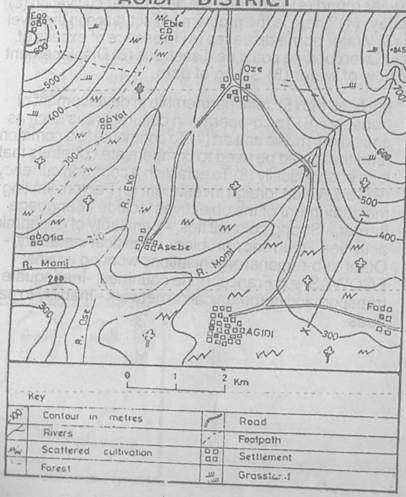
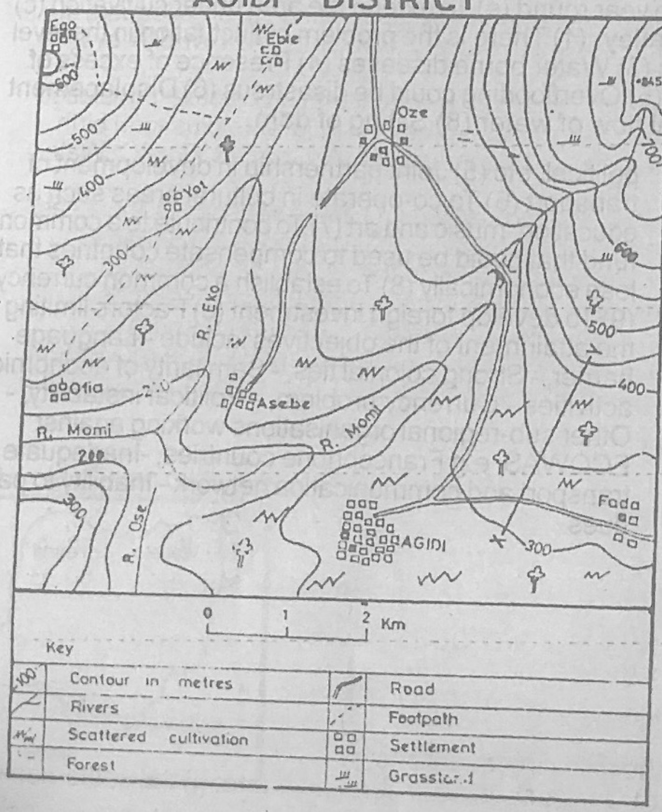
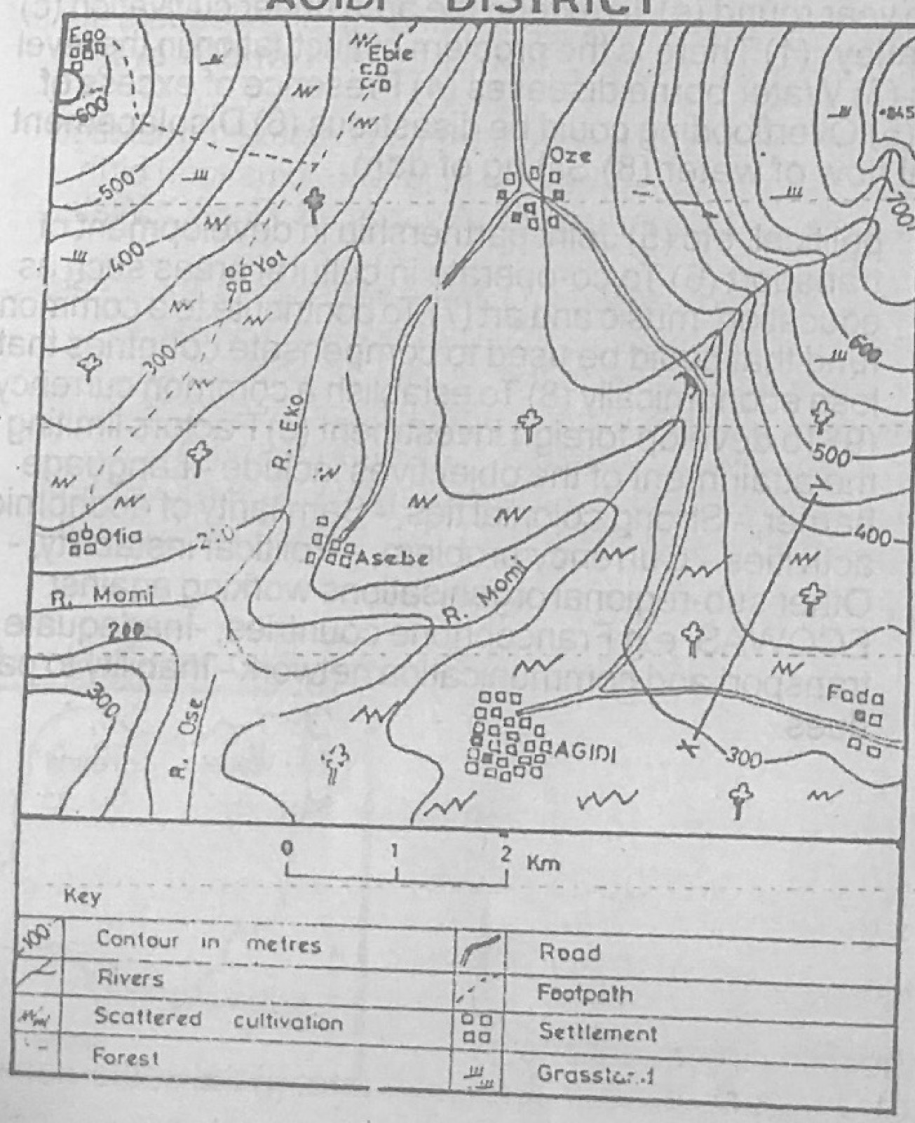
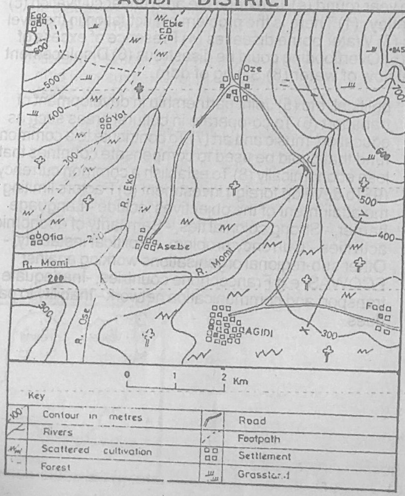
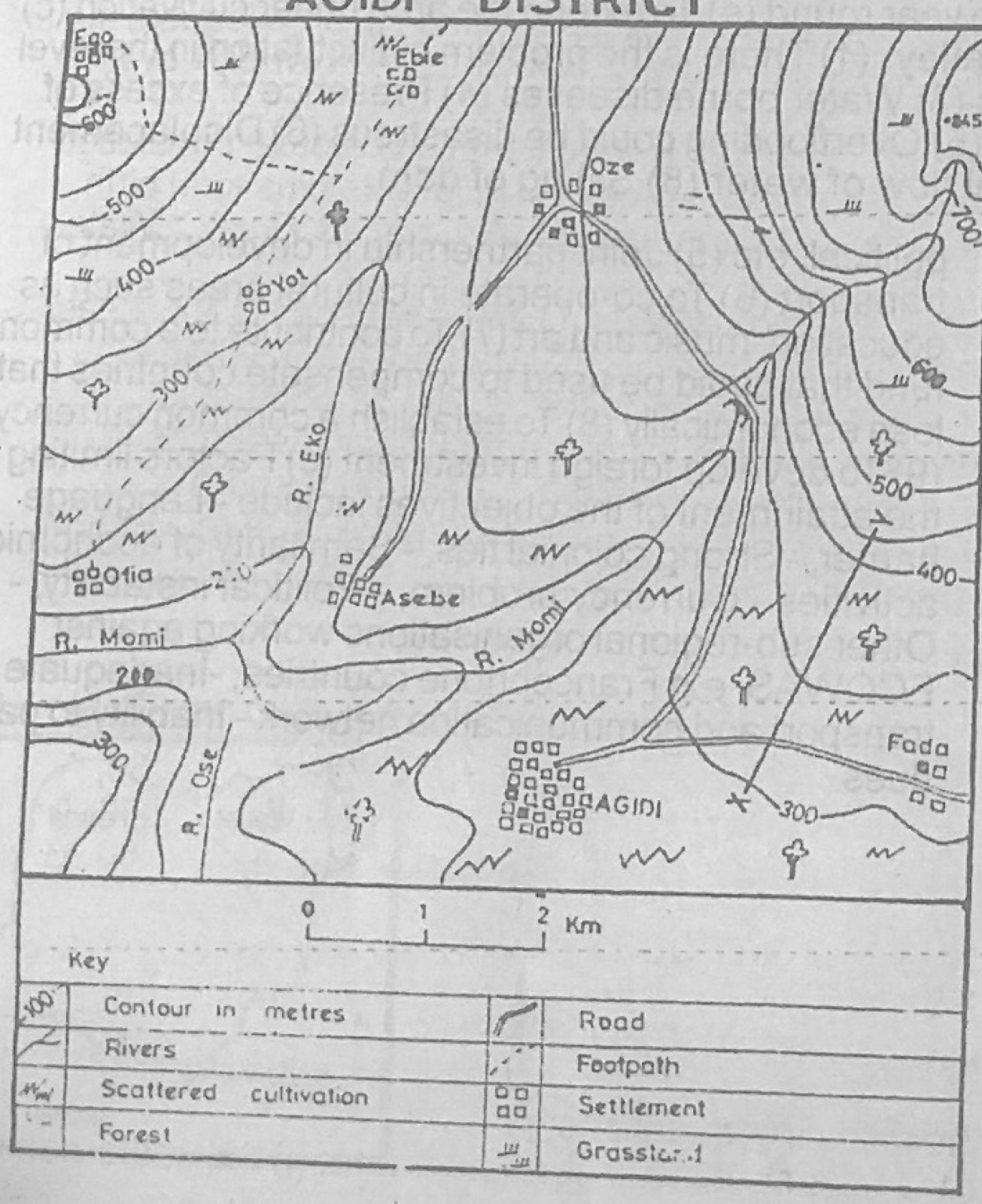
Study the map of AGIDI DISTRICT to answer this question. The scale of the map expressed as a representative fraction is

Diagram for this question
  1. A.1 : 50,000
  2. B.1 : 120,000
  3. C.1 : 150,000
  4. D.1 : 250,000
Show the answer and explanation

Answer: A (1 : 50,000)

Explanation

On the original map each 1 km division of the linear scale measures 2 cm, so 1 cm stands for 0.5 km = 50,000 cm.

Open this question

Question 2

Map Scale, Distance and Direction

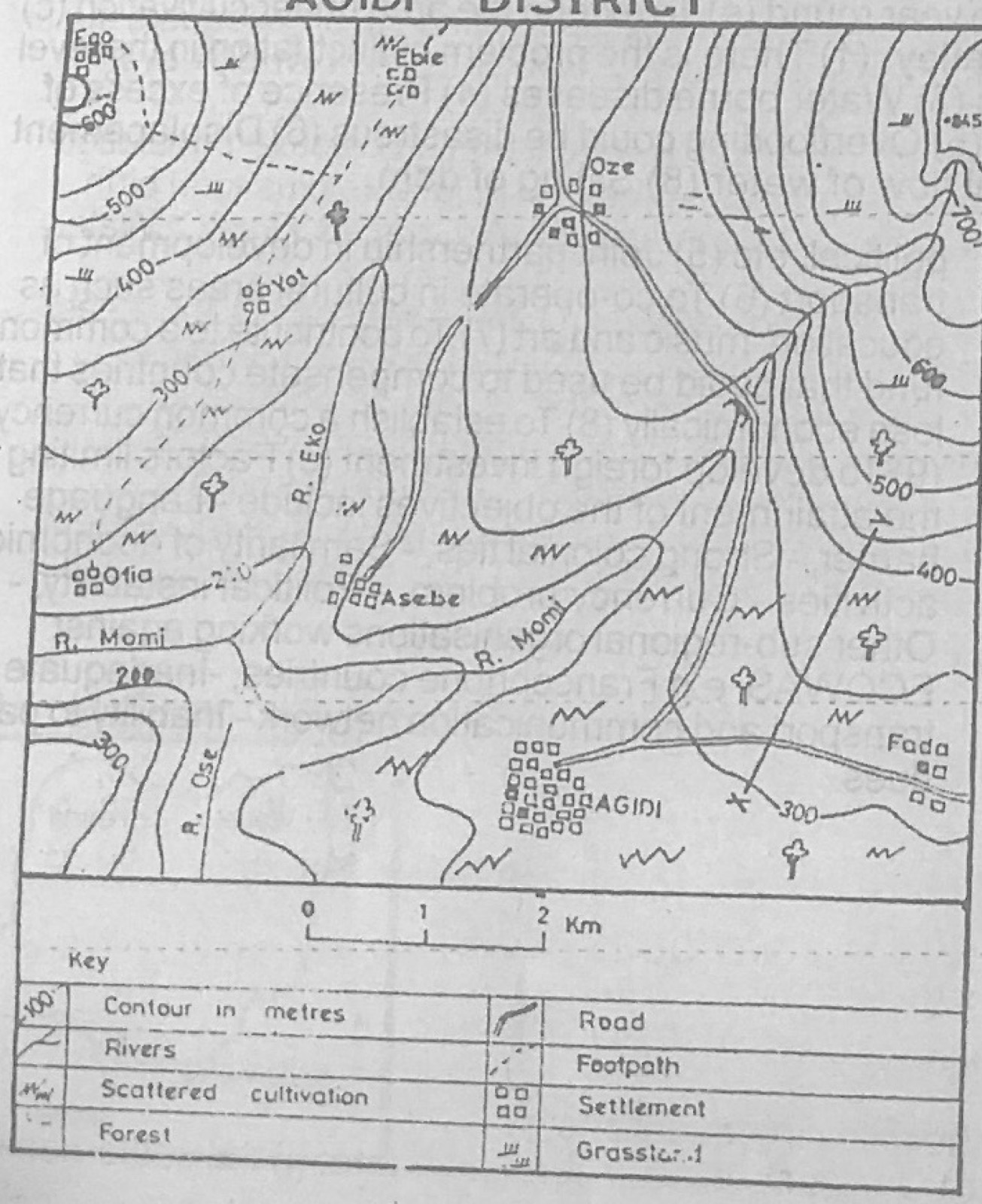
Study the map of AGIDI DISTRICT to answer this question. The direction of Ebie from Oze is

Diagram for this question
  1. A.035°
  2. B.085°
  3. C.127°
  4. D.305°
Show the answer and explanation

Answer: D (305°)

Explanation

Ebie lies to the north-west of Oze, so its bearing from Oze is between 270° and 360°: about 305°.

Open this question

Question 3

Relief and Map Interpretation

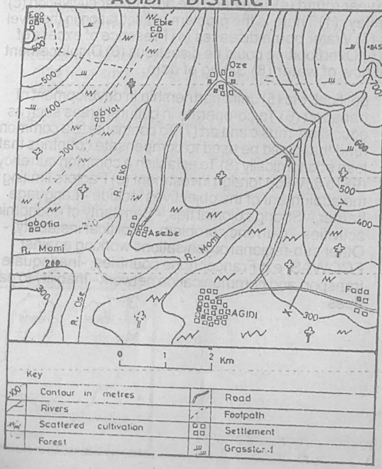
Study the map of AGIDI DISTRICT to answer this question. The feature marked X – Y is a

Diagram for this question
  1. A.cuesta
  2. B.cliff
  3. C.spur
  4. D.ridge
Show the answer and explanation

Answer: C (spur)

Explanation

Between X and Y the contours bend outwards from the higher ground, forming a tongue of land that slopes down: a spur.

Open this question

Question 4

Relief and Map Interpretation

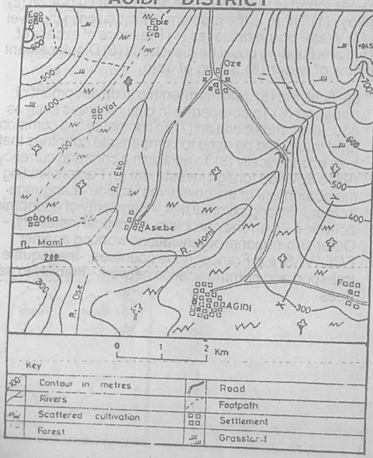
Study the map of AGIDI DISTRICT to answer this question. How many tributaries has river Momi?

Diagram for this question
  1. A.1
  2. B.2
  3. C.5
  4. D.6
Show the answer and explanation

Answer: B (2)

Explanation

Two rivers join the Momi on the map: the Eko and the Ose.

Open this question

Question 5

Relief and Map Interpretation

Study the map of AGIDI DISTRICT to answer this question. What is the likely occupation of the people of Agidi District?

Diagram for this question
  1. A.Mining
  2. B.Trading
  3. C.Agriculture
  4. D.Boat building
Show the answer and explanation

Answer: C (Agriculture)

Explanation

Scattered cultivation and grassland symbols cover the map, so most people are farmers.

Open this question

Question 6

Relief and Map Interpretation

Study the map of AGIDI DISTRICT to answer this question. The highest contour line on the map is

Diagram for this question
  1. A.850m
  2. B.800m
  3. C.600m
  4. D.500m
Show the answer and explanation

Answer: B (800m)

Explanation

The innermost contour of the high ground in the north-east, just below the 845 m spot height, is the 800 m line.

Open this question

Question 7

Map Scale, Distance and Direction

Study the map of AGIDI DISTRICT to answer this question. The actual distance from Ofia to Yot as the 'crow flies' is

Diagram for this question
  1. A.15 km
  2. B.12km
  3. C.7 km
  4. D.3km
Show the answer and explanation

Answer: D (3km)

Explanation

Measure the straight line from Ofia to Yot and compare it with the linear scale: about 3 km.

Open this question

Question 8

Relief and Map Interpretation

Study the map of AGIDI DISTRICT to answer this question. The second largest settlement on the map is

Diagram for this question
  1. A.Oze
  2. B.Agidi
  3. C.Asebe
  4. D.Fada
Show the answer and explanation

Answer: C (Asebe)

Explanation

Agidi has the most settlement symbols; Asebe has the next largest number.

Open this question

Question 9

Relief and Map Interpretation

Study the map of AGIDI DISTRICT to answer this question. Which of the following towns are not intervisible?

Diagram for this question
  1. A.Agidi and Fada
  2. B.Oze and Asebe
  3. C.Ebie and Yot
  4. D.Ofia and Ego
Show the answer and explanation

Answer: D (Ofia and Ego)

Explanation

Ofia and Ego are separated by the high ground (over 500 m) in the west, which blocks the line of sight.

Open this question

Question 10

Relief and Map Interpretation

Study the map of AGIDI DISTRICT to answer this question. The symbol •845 in the North eastern part of the map is known as

  1. A.trigonometrical station
  2. B.contour line
  3. C.spot height
  4. D.hachures.
Show the answer and explanation

Answer: C (spot height)

Explanation

A dot with a height value beside it is a spot height.

Open this question

Question 11

Statistical Maps and Diagrams

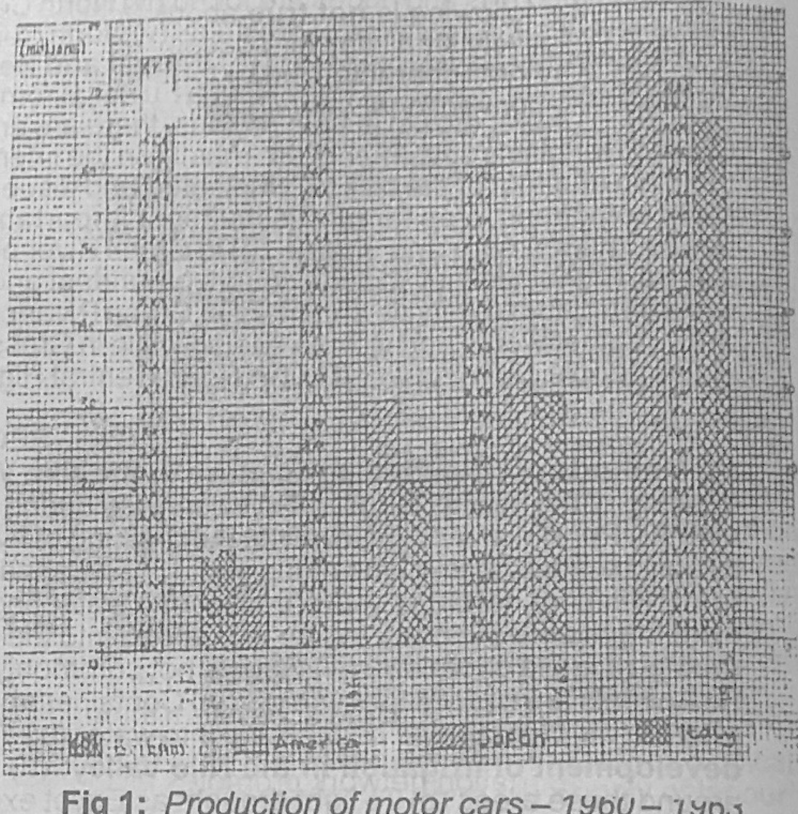
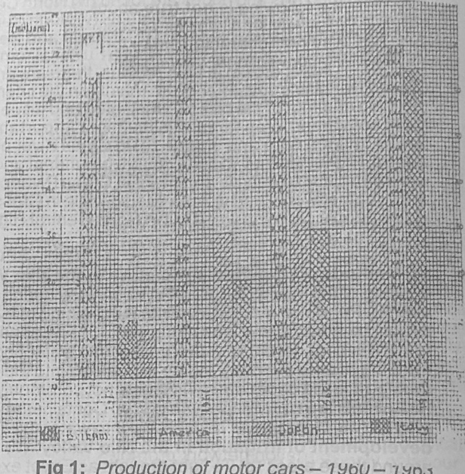
Use Figure 1 (Production of motor cars, 1960-1963) to answer this question. The Figure 1 is known as

Diagram for this question
  1. A.simple bar graph
  2. B.divided bar graph
  3. C.percentage bar graph
  4. D.group bar graph
Show the answer and explanation

Answer: D (group bar graph)

Explanation

Figure 1 shows separate bars for Britain, America, Japan and Italy placed side by side for each year, which is a group (multiple) bar graph.

Open this question

Question 12

Statistical Maps and Diagrams

Use Figure 1 (Production of motor cars, 1960-1963) to answer this question. The greatest advantage of the Figure 1 is that it

Diagram for this question
  1. A.makes for easy comparison of the data represented
  2. B.shows the total value of the data represented.
  3. C.shows the percentage decrease in the value of the data represented.
  4. D.is very easy to construct.
Show the answer and explanation

Answer: A (makes for easy comparison of the data represented)

Explanation

Bars for each country stand side by side, so their production can be compared at a glance.

Open this question

Question 15

The Earth and Solar System

The biggest member of the solar system is

  1. A.Mars.
  2. B.the moon
  3. C.the sun
  4. D.Neptune.
Show the answer and explanation

Answer: C (the sun)

Explanation

The sun is far larger than all the planets put together.

Open this question

Question 17

The Earth and Solar System

The latitude which marks the limits of the sun's apparent movement north and south of the equator is

  1. A.23½°
  2. B.45½°
  3. C.65½°
  4. D.90°.
Show the answer and explanation

Answer: A (23½°)

Explanation

The overhead sun moves between the Tropics of Cancer and Capricorn, at 23½° N and S.

Open this question

Question 18

Structure of the Earth

The average density of Sima is

  1. A.2.0
  2. B.2.9
  3. C.3.0
  4. D.3.7
Show the answer and explanation

Answer: C (3.0)

Explanation

Sima (silica and magnesium, basaltic rock) has a density of about 3.0, heavier than sial at 2.7.

Open this question

Question 19

Rocks

An example of a crystalline rock is

  1. A.peat
  2. B.limestone
  3. C.granite
  4. D.sandstone
Show the answer and explanation

Answer: C (granite)

Explanation

Granite is an igneous rock made of interlocking crystals; the others are sedimentary.

Open this question

Question 20

Earth Movements and Vulcanicity

When plateaux are enclosed by fold mountains they are known as

  1. A.intermont plateaux
  2. B.lava plateaux
  3. C.volcanic plateaux
  4. D.dissected plateaux
Show the answer and explanation

Answer: A (intermont plateaux)

Explanation

A plateau surrounded by fold mountains (e.g. Tibet) is an intermont plateau.

Open this question

Question 21

Coastal Landforms

Which of the following is formed by coastal erosion?

  1. A.Spit
  2. B.Bay
  3. C.Lagoon
  4. D.Tombolo
Show the answer and explanation

Answer: B (Bay)

Explanation

Waves wear back soft rock to form a bay; spits, lagoons and tombolos are built by deposition.

Open this question

Question 22

Rocks

A horizontal intrusion of molten magma into the bedding plane of sedimentary rocks is called

  1. A.Phacolith
  2. B.Lacolith
  3. C.Sill
  4. D.Batholith.
Show the answer and explanation

Answer: C (Sill)

Explanation

Magma that spreads as a flat sheet along the bedding planes cools to form a sill.

Open this question

Question 23

Oceans and Lakes

Which of the following ocean currents enhances rainfall in its immediate hinterland?

  1. A.Canaries current
  2. B.Mozambique current
  3. C.Californian current
  4. D.West Australian current
Show the answer and explanation

Answer: B (Mozambique current)

Explanation

The warm Mozambique current warms and moistens the winds blowing onshore, bringing rain; the others are cold currents.

Open this question

Question 24

Weather

Which of the following is not an element of climate?

  1. A.Rainfall
  2. B.Humidity
  3. C.Temperature
  4. D.Fog
Show the answer and explanation

Answer: D (Fog)

Explanation

Rainfall, humidity and temperature are measured elements of climate; fog is a weather condition (a form of condensation).

Open this question

Question 25

Weather

Given that the temperature of Station X (at sea-level) is 80°F (26.7°C) at a particular time, what would be the temperature of Y [1300 ft (400 m) above sea level] at the same time? (Both stations are on the same latitude).

  1. A.68°F (20°C)
  2. B.70°F (21°C)
  3. C.76°F (24.4°C)
  4. D.80°F (26.7°C)
Show the answer and explanation

Answer: C (76°F (24.4°C))

Explanation

Temperature falls about 6°C per 1000 m (about 0.6°C per 100 m): 400 m gives a fall of about 2.4°C, so 26.7 − 2.4 ≈ 24.3°C (76°F).

Open this question

Question 26

Weather

Environmental lapse rate is

  1. A.1°C for every 300 m ascent
  2. B.2°C for every 100 m ascent
  3. C.0.6°C for every 100 m ascent
  4. D.0.8°C for every 1000 m ascent.
Show the answer and explanation

Answer: C (0.6°C for every 100 m ascent)

Explanation

Air temperature normally falls about 6°C per 1000 m, i.e. 0.6°C per 100 m.

Open this question

Question 27

Weather

Dark clouds extending to height of about 15,000 metres which bring a lot of rain to tropical lands are known as

  1. A.cirrocumulus.
  2. B.cirrus
  3. C.cumulonimbus
  4. D.cumulus
Show the answer and explanation

Answer: C (cumulonimbus)

Explanation

Cumulonimbus are tall, dark thunder clouds that give heavy tropical downpours.

Open this question

Question 28

Weather

Which of the following is not an element of weather?

  1. A.Condensation
  2. B.Cloud cover
  3. C.Rainfall
  4. D.Sunshine
Show the answer and explanation

Answer: A (Condensation)

Explanation

Condensation is a process; cloud cover, rainfall and sunshine are measured elements of weather.

Open this question

Question 30

Weather

The type of rainfall characterized by torrential downpour in the tropics or during summers in the temperate interiors is called

  1. A.convectional rainfall
  2. B.frontal rainfall
  3. C.orographic rainfall
  4. D.cyclonic rainfall
Show the answer and explanation

Answer: A (convectional rainfall)

Explanation

Strong surface heating makes moist air rise rapidly, giving short, heavy convectional downpours.

Open this question

Question 31

Settlement

Which of the following settlement types is the largest in size?

  1. A.Megalopolis
  2. B.Village
  3. C.Town
  4. D.City
Show the answer and explanation

Answer: A (Megalopolis)

Explanation

A megalopolis is a huge urban region made of several merged cities.

Open this question

Question 32

Vegetation

A plant which is adapted to living in a region where little moisture is available is called

  1. A.helophyte
  2. B.hygrophyte
  3. C.xerophyte
  4. D.hydrophyte
Show the answer and explanation

Answer: C (xerophyte)

Explanation

Xerophytes are drought-resistant plants such as cacti.

Open this question

Question 33

Nigeria: People and Economy

All the following minerals are found in Nigeria except

  1. A.coal
  2. B.bauxite
  3. C.tin ore
  4. D.columbite
Show the answer and explanation

Answer: B (bauxite)

Explanation

Nigeria has coal (Enugu), tin and columbite (Jos) but no workable bauxite.

Open this question

Question 34

Nigeria: People and Economy

Which of the following occupations is not common among the peoples of Southern coastlands of Nigeria?

  1. A.Fishing
  2. B.Lumbering
  3. C.Trading
  4. D.Cattle rearing
Show the answer and explanation

Answer: D (Cattle rearing)

Explanation

Tsetse flies and the wet forest make cattle rearing rare in the south; it is a northern activity.

Open this question

Question 35

Mining and Energy

Which of the following factors is least necessary for the development of hydro-electric power?

  1. A.High domestic demand
  2. B.Natural reservoirs and falls
  3. C.Rain-fed rivers
  4. D.Heavy capital outlay
Show the answer and explanation

Answer: C (Rain-fed rivers)

Explanation

What matters is a large, steady flow of water; the river need not be rain-fed (snow-fed and lake-fed rivers also work).

Open this question

Question 36

Nigeria: Physical Setting

A major hazard to both human and aquatic life in some coastal areas of Nigeria is

  1. A.air pollution
  2. B.overfishing
  3. C.desalination of sea water.
  4. D.oil spillage.
Show the answer and explanation

Answer: D (oil spillage.)

Explanation

Oil spills in the Niger Delta poison water, kill fish and destroy farmland.

Open this question

Question 37

Rivers and River Landforms

The intensity of erosion by a river is determined by the

  1. A.volume of water only.
  2. B.gradient of the valley only.
  3. C.gradient and width of the valley
  4. D.volume of water, gradient of the valley and the load carried.
Show the answer and explanation

Answer: D (volume of water, gradient of the valley and the load carried.)

Explanation

A river erodes more when it has more water, a steeper gradient and more load to use as tools.

Open this question

Question 38

Agriculture, Fishing and Lumbering

Transhumance involves the movement of

  1. A.people from rural to urban areas.
  2. B.migrant labour from source to receiving regions.
  3. C.settlers from highlands to lowlands for farming.
  4. D.cattle up and down mountains for pasture.
Show the answer and explanation

Answer: D (cattle up and down mountains for pasture.)

Explanation

Transhumance is the seasonal movement of herds between highland and lowland pastures.

Open this question

Question 40

Environmental Hazards and Conservation

Deforestation can be caused by

  1. A.an increase in population
  2. B.re-afforestation
  3. C.the establishment of forest reserves.
  4. D.a decrease in the use of fuel wood.
Show the answer and explanation

Answer: A (an increase in population)

Explanation

More people need more land for farms and houses and more fuelwood, so more forest is cleared.

Open this question

Question 41

Environmental Hazards and Conservation

Man has interferred with the ecosystem through. I. farming II. modification of weather and climate III. overgrazing.

  1. A.I only
  2. B.II only
  3. C.II and III only
  4. D.I, II and III
Show the answer and explanation

Answer: D (I, II and III)

Explanation

Farming, changing the climate (e.g. through pollution and cloud seeding) and overgrazing all alter ecosystems.

Open this question

Question 42

Transport, Trade and Tourism

Good transportation network promotes all the following except

  1. A.national disintegration
  2. B.international trade
  3. C.movement of people and goods.
  4. D.spread of ideas and technology.
Show the answer and explanation

Answer: A (national disintegration)

Explanation

Good transport links people together, promoting unity, not disintegration.

Open this question

Question 43

Manufacturing Industry

The most ideal location for an iron and steel industry is one that has I. a large population II. an adequate supply of iron ore. III. a good transport network. IV. an abundant supply of coal.

  1. A.I and II only
  2. B.I, II and IV
  3. C.I, III and IV
  4. D.II, III and IV
Show the answer and explanation

Answer: D (II, III and IV)

Explanation

Iron ore, coal and good transport for these bulky materials matter most; a large local population is less important.

Open this question

Question 44

Population

A net population growth is the

  1. A.surplus of emigrants over immigrants plus total death.
  2. B.actual population inhabiting a place.
  3. C.surplus of birth over death plus net migration
  4. D.surplus of immigrants plus total birth.
Show the answer and explanation

Answer: C (surplus of birth over death plus net migration)

Explanation

Net growth = natural increase (births minus deaths) plus net migration.

Open this question

Question 45

Mining and Energy

Which of the following is the cheapest source of power for a large scale industry?

  1. A.Coal
  2. B.Gas
  3. C.Water
  4. D.Petroleum
Show the answer and explanation

Answer: C (Water)

Explanation

Water (hydro-electric power) is the cheapest source of power for large industries: once the dam is built, the running water is free and running costs are low. Coal, gas and petroleum have to be mined, bought and transported.

Open this question

Question 46

Nigeria: Physical Setting

The climate of Nigeria is characterized by

  1. A.continuous seasons
  2. B.two seasons
  3. C.three seasons
  4. D.four seasons.
Show the answer and explanation

Answer: B (two seasons)

Explanation

Nigeria has a wet (rainy) season and a dry season.

Open this question

Question 47

West Africa and ECOWAS

The largest producer of gold in West Africa is

  1. A.Nigeria
  2. B.The Gambia
  3. C.Sierra Leone
  4. D.Ghana
Show the answer and explanation

Answer: D (Ghana)

Explanation

Ghana (formerly the Gold Coast) is West Africa's leading gold producer, from mines such as Obuasi.

Open this question

Question 48

Transport, Trade and Tourism

The initial problems of rail and road development in Africa were due primarily to the

  1. A.dense population
  2. B.inadequate mineral resources
  3. C.difficult physical environment
  4. D.insufficient agricultural resources
Show the answer and explanation

Answer: C (difficult physical environment)

Explanation

Thick forests, swamps, escarpments, rivers and rugged plateaux made building roads and railways hard.

Open this question

Question 50

West Africa and ECOWAS

The benefits to be derived by ECOWAS member countries include all the following except

  1. A.free movement of people across member countries
  2. B.territorial expansion
  3. C.free flow of capital
  4. D.the creation of large market
Show the answer and explanation

Answer: B (territorial expansion)

Explanation

ECOWAS is an economic union; it does not give members more territory.

Open this question

Theory question 101

Population

(a) Identify four patterns of population movement within a country. (b) Give five reasons that may lead to any one pattern of the movements identified in 1(a) above. (c) Highlight three possible effects of population movement on the: (i) source region; (ii) destination.

Show the model answer
Model answer

(a) Rural-rural, rural-urban, urban-urban, urban-rural; seasonal migration; transhumance.
(b) e.g. Rural-urban: search for jobs and higher wages; better schools and hospitals; social amenities (electricity, water, entertainment); poverty and lack of land in villages; escape from communal clashes or disasters (floods, drought); to join relatives; trade.
(c)(i) Source: loss of young, able-bodied labour; fall in farm output; fewer people and slower development; mainly old people and children left; less pressure on land.
(ii) Destination: overcrowding and slums; pressure on housing, water, schools and transport; unemployment and crime; more labour for industries; larger market; high cost of living.

Explanation

Choose one pattern for part (b).

Open this question

Theory question 102

Settlement

(a) Highlight any four characteristics of urban centres. (b) Explain four ways in which urban centres depend on their surrounding rural areas. (c) Describe three problems facing rural areas.

Show the model answer
Model answer

(a) Large, dense population; most people in secondary and tertiary jobs; built-up area with many amenities (hospitals, banks, schools); mixed (heterogeneous) population; administrative and commercial centres; congestion and pollution.
(b) Food supply (grain, tubers, vegetables, meat); raw materials for industries (cotton, cocoa, timber); labour from rural migrants; market for manufactured goods; fuelwood and herbs; recreation and retirement homes.
(c) Rural-urban migration and loss of labour; lack of amenities (water, electricity, health care); poor roads and transport; low farm output and poverty; unemployment and underemployment; poor housing.

Explanation

Part (b) is about what towns get from villages.

Open this question

Theory question 103

Transport, Trade and Tourism

(a) Identify any four ocean routes used in world trade (b) In what four ways has water transportation contributed to economic development? (c) State four ways of improving transportation on inland waterways.

Show the model answer
Model answer

(a) North Atlantic route; Mediterranean-Asiatic (Suez Canal) route; Cape of Good Hope route; South Atlantic route; North Pacific route; Panama Canal route.
(b) Cheap movement of bulky goods (oil, ores, grain) between countries; growth of world trade and export production; growth of port towns; employment; foreign exchange and government revenue; cultural contact.
(c) Dredging channels; clearing water weeds; building dams and locks to keep a steady depth; cutting canals to straighten routes; navigational aids; better boats and river ports; training of personnel.

Explanation

Name the routes by the oceans and canals they use.

Open this question

Theory question 104

Nigeria: Physical Setting

(a) On an outline map of Nigeria, show and name: (i) Rivers Kaduna, Niger and Cross; (ii) two important dams; (iii) one delta coast; (iv) one inland lake. (b) Identify any three contributions of rivers to the development of Nigeria. (c) Outline any three problems encountered in the utilization of Nigerian rivers.

Show the model answer
Model answer

(a) Map showing the Niger from the north-west to the Delta, the Kaduna joining it from the north-east, the Cross River in the south-east; dams such as Kainji (Niger), Jebba (Niger), Shiroro (Kaduna); the Niger Delta coast; Lake Chad (or Kainji Lake) as the inland lake.
(b) Navigation and transport; fishing; water for homes and industry; irrigation; HEP; tourism and recreation; river basin development.
(c) Seasonal fall in water level; rapids and waterfalls; silting and sandbars at the mouths; water weeds; pollution; short, narrow and shallow channels.

Explanation

Show each river in its correct position.

Open this question

Theory question 105

Nigeria: People and Economy

(a) Draw an outline map of Nigeria and on it show and name: (i) two industrial zones; (ii) one town in each zone; (iii) one industry in one of the zones. (b) Outline two factors that favour the location of the named industry in (a)(iii) above. (c) Highlight four problems facing industries in Nigeria.

Show the model answer
Model answer

(a) e.g. Lagos-Ota-Abeokuta (western) zone with Lagos; Kaduna-Kano (north-central) zone with Kano; Port Harcourt-Aba zone; Enugu-Onitsha zone. Industry: cement at Ewekoro (Ogun State) or textiles at Kaduna.
(b) e.g. Cement at Ewekoro: nearness to limestone; large market in Lagos and Abeokuta; power supply; transport; labour; capital; government policy.
(c) Erratic power supply; inadequate raw materials and reliance on imports; poor transport; shortage of capital and skilled labour; competition from imported goods; poor management; low demand.

Explanation

Pick one industry for (b).

Open this question

Theory question 106

Nigeria: People and Economy

(a) On an outline map of Nigeria, locate and name: (i) the Niger-Benue trough; (ii) Rivers Niger, Benue, Gongola and Donga; (iii) one confluence town in the region. (b) Write a geographical essay on the physical characteristics of the Niger-Benue trough. (c) Outline four ways in which the economic activities in the Niger-Benue trough are related to its physical characteristics.

Show the model answer
Model answer

(a) Map showing the trough along the middle Niger and the Benue valley, the Gongola joining the Benue from the north, the Donga from the south-east, with Lokoja at the Niger-Benue confluence.
(b) Low-lying land mostly below 300 m; wide flood plains, swamps and sandbars; underlain by sedimentary rocks with flat-topped hills; tropical hinterland climate with about 1200-1500 mm of rain and a dry season; high temperatures and humidity; Guinea savanna vegetation; drained by the Niger, Benue, Kaduna, Gongola, Donga.
(c) Rivers and flood plains support irrigation and rice and sugarcane farming; rivers support fishing and water transport; dams give HEP (Kainji, Jebba); limestone and clay support cement and pottery; salt from sedimentary deposits; fertile alluvial soils support food crops (yam, soya beans).

Explanation

Link each activity to a named physical feature.

Open this question

Theory question 107

Geography of Africa

(a) Draw a sketch map of Africa and on it show: (i) latitudes 30°N and 35°S; (ii) longitudes 15°W and 20°E; (iii) one area each of equatorial climate, tropical continental climate and desert climate; (iv) one major town in each climatic belt. (b) Explain any four ways in which the tropical continental climate affects the vegetation in the area.

Show the model answer
Model answer

(a) 30°N through southern Morocco, Algeria, Libya and Egypt (near Cairo); 35°S just south of the Cape; 15°W off the Senegal coast (near Dakar); 20°E through Libya, Chad, Central African Republic, DR Congo, Angola and Namibia/South Africa. Equatorial: Congo Basin (Kisangani) or Guinea coast; tropical continental: Sudan/savanna belt (N'Djamena, Kano, Ibadan area); desert: Sahara (Tripoli edge, In Salah) or Kalahari.
(b) Seasonal rain gives deciduous trees that shed leaves in the dry season; low and unreliable rainfall gives grassland with scattered trees; long dry season leads to adaptations such as long tap roots, thick bark and small or thorny leaves; length of the rainy season decides how luxuriant the grass is; height of grass and trees falls as rainfall decreases northward; grass dries and burns in the dry season and sprouts again with the rains.

Explanation

Draw the latitude and longitude lines straight and labelled.

Open this question

Theory question 108

Geography of Africa

(a) Describe the major method of gold mining in South Africa. (b) Highlight any four benefits of gold mining to the country. (c) Identify three problems which result from gold mining activities.

Show the model answer
Model answer

(a) Deep underground (shaft) mining on the Witwatersrand: vertical shafts sunk to the gold-bearing reef (often over 3,000 m deep); horizontal tunnels (adits) driven to the reef; holes drilled and blasted with explosives; broken ore carried to the surface by lifts and conveyors; crushed and treated (cyanide process) to extract gold.
(b) Foreign exchange; employment; government revenue; growth of towns (Johannesburg); infrastructure (railways, roads, power); growth of other industries and manpower development.
(c) Dangerous working conditions and accidents (rock falls, heat); land degradation and mine dumps; pollution of water and air; exhaustion of deposits; labour unrest and migrant-labour problems.

Explanation

Underground mining is used because the reef is very deep.

Open this question

Theory question 109

Geography of Africa

(a) Draw a sketch map of Africa and on it show and name: (i) Nile Basin; (ii) Zaire (Congo) Basin; (iii) Mediterranean region in North Africa. (b) Write geographical notes on any two of the following: (i) Irrigation agriculture in the Nile Basin. (ii) Lumbering in Zaire (Democratic Republic of Congo). (iii) Fruit farming in North Africa.

Show the model answer
Model answer

(a) Nile Basin from Lake Victoria/Ethiopia to the Mediterranean; Congo Basin in central Africa astride the equator; Mediterranean coastlands of Morocco, Algeria and Tunisia.
(b) Irrigation in the Nile Basin: low rainfall makes it necessary; basin and perennial methods; dams (Aswan, Sennar); schemes such as Gezira; crops cotton, wheat, rice, sugarcane; problems of salinity, silting and bilharzia.
Lumbering in the Congo: huge equatorial forest; hardwoods such as mahogany, ebony, limba; trees felled, floated on the Congo and its tributaries or carried by rail to Matadi/Boma for export; problems: scattered species, dense undergrowth, poor roads, rapids, heavy logs.
Fruit farming in North Africa: Mediterranean climate with hot dry summers and mild wet winters; citrus, grapes, olives, dates, figs; irrigation in summer; markets in Europe; problems of drought, pests, price changes.

Explanation

Choose two topics and cover location, methods, products and problems.

Open this question

Theory question 202

Surveying

(a) Describe the Prismatic Compass. (b) Highlight four basic precautions that should be taken when making a compass traverse.

Show the model answer
Model answer

(a) A circular magnetic compass used in surveying to take bearings; has a magnetic needle attached to a card graduated 0°-360°; a prism with a sighting slit on one side and a sight vane with a vertical hair on the opposite side; the prism reflects the reading on the card so the surveyor can read the bearing while sighting; often has a lid/glass cover and a lock/brake for the card.
(b) Keep away from magnetic materials (iron sheets, railway lines, power lines, vehicles) and remove metal objects from pockets; hold the compass level so the card swings freely; let the needle settle before reading; take a back bearing from the other end, which should differ by exactly 180°; record readings carefully; check the compass is not faulty.

Explanation

Precautions are about avoiding errors in bearings.

Open this question

Theory question 203

Latitude, Longitude and Time

(a) Distinguish between Meridians and Parallels. (b) A football match is to be played on Saturday in New Zealand (150°E) between the host country and Nigeria (15°E). If the match is to be televised live, at what time should Nigerians tune in their television sets to watch the kick-off scheduled for 4.00 p.m. in New Zealand?

Show the model answer
Model answer

(a) Meridians are lines of longitude running north-south from pole to pole; parallels are lines of latitude running east-west. Meridians meet at the poles; parallels never meet. Meridians are numbered 0°-180° E and W of Greenwich; parallels 0°-90° N and S of the equator. All meridians are equal in length and form great circles with their opposites; parallels get shorter towards the poles and only the equator is a great circle. Meridians are used to work out time; parallels to locate places N/S and show climatic zones.
(b) Difference in longitude = 150° − 15° = 135°. 15° = 1 hour, so 135° = 9 hours. Nigeria is west, so behind: 4.00 p.m. − 9 hours = 7.00 a.m. on Saturday.

Explanation

West is behind, east is ahead.

Open this question

Theory question 204

Earth Movements and Vulcanicity

(a) Explain the term vulcanicity? (b) Describe the characteristics and mode of formation of any one of the following: (i) Batholith; (ii) Dyke; (iii) Composite cone. (c) In what four ways are volcanic rocks important to man?

Show the model answer
Model answer

(a) Vulcanicity is all the processes by which molten material (magma), gases and solids are forced from inside the earth into the crust or onto the surface.
(b) Batholith: very large dome-shaped mass of intrusive igneous rock (granite), hundreds of km across, deep-seated, often forming the core of fold mountains; formed when a huge body of magma rises into the crust and cools slowly; exposed later by denudation.
Dyke: narrow, vertical or steeply inclined wall of igneous rock cutting across the bedding planes; formed when magma is forced into vertical cracks and cools; may stand out as a ridge or form a trench when eroded; can cause waterfalls (e.g. ring dykes near Jos).
Composite cone: tall, steep-sided conical volcano made of alternate layers of ash and lava with a central crater and side (parasitic) cones; formed by repeated explosive eruptions (Mt Cameroon, Kilimanjaro, Fuji).
(c) Fertile volcanic soils for farming; building and road stone (granite, basalt); minerals (gold, diamond, tin); tourism and hot springs; geothermal power; landforms for defence and scenery.

Explanation

Choose one feature and give both characteristics and formation.

Open this question

Theory question 205

Underground Water and Karst

(a) What is a spring? (b) With the aid of diagrams, describe three ways by which springs may be formed.

Show the model answer
Model answer

(a) A spring is a natural outflow of underground water at the earth's surface.
(b) Diagrams for any three: where a permeable rock lies on an impermeable rock and the junction meets the slope (scarp-foot / hillside spring); where the water table reaches the surface in a valley; along a fault that brings impermeable rock against permeable rock; where a dyke blocks the flow of groundwater; in limestone where an underground stream comes out at the base of the rock (vauclusian spring); hot springs in volcanic areas.

Explanation

Each diagram should show permeable and impermeable layers and the water table.

Open this question

Theory question 206

Weather

(a) Name the instruments used in measuring the following: (i) Rainfall; (ii) Humidity (iii) Temperature (iv) Wind. (b) With the aid of a diagram, describe the instrument used to measure rainfall. (c) Explain how the instrument described in 6(b) above is used.

Show the model answer
Model answer

(a)(i) Rain gauge. (ii) Hygrometer (wet and dry bulb thermometers). (iii) Thermometer / Six's maximum and minimum thermometer. (iv) Wind vane (direction) and anemometer (speed).
(b) Diagram: cylindrical metal case partly sunk in the ground; funnel at the top; inner collecting jar/bottle; graduated measuring cylinder.
(c) Place it in an open space away from trees and buildings, with the rim about 30 cm above the ground to avoid splashing; rain enters the funnel and collects in the jar; every day at a fixed time the water is poured into the measuring cylinder and read in mm; daily totals are added for the month and the year.

Explanation

Label all the parts of the rain gauge.

Open this question

Theory question 207

Climate

(a) Describe the characteristics of the equatorial climate. (b) Highlight the main features of the vegetation type associated with the climatic region in 7(a) above.

Show the model answer
Model answer

(a) High temperature all year (about 27°C); very small annual range (under 3°C); heavy rainfall over 2000 mm spread through the year with no real dry season; double maxima; convectional afternoon thunderstorms; high relative humidity (over 80%); much cloud; small daily range.
(b) Equatorial rain forest: dense, evergreen; tall trees in three layers forming a continuous canopy; many species mixed, no pure stands; hardwoods (mahogany, iroko, ebony, sapele); buttress roots; climbers, lianas and epiphytes; little undergrowth where the canopy is thick.

Explanation

Give figures for temperature and rainfall.

Open this question

Theory question 208

Environmental Hazards and Conservation

(a) Define the term flooding. (b) Highlight four causes of flooding. (c) Outline four effects of flooding (d) What two measures can be taken to control flooding?

Show the model answer
Model answer

(a) Flooding is the covering of normally dry land by water when a river, lake or the sea rises above its usual level.
(b) Heavy or prolonged rainfall; blocked drains and waterways; building on flood plains and water courses; rivers overflowing their banks; release of water from or collapse of dams; rise in sea level / storm surges; deforestation increasing run-off.
(c) Destruction of farms and crops; destruction of houses and property; loss of life; food shortage and high prices; disease outbreaks; contamination of water supply; disruption of transport, schools and markets.
(d) Dredging and channelising rivers; clearing drains regularly; building dams, levees and embankments; enforcing building laws on flood plains; afforestation.

Explanation

Each part asks for a set number of points.

Open this question