WAEC Geography 2024 past questions and answers

55 questions. Try each one, then open the answer to check yourself and read the explanation.

Question 3

Relief and Map Interpretation

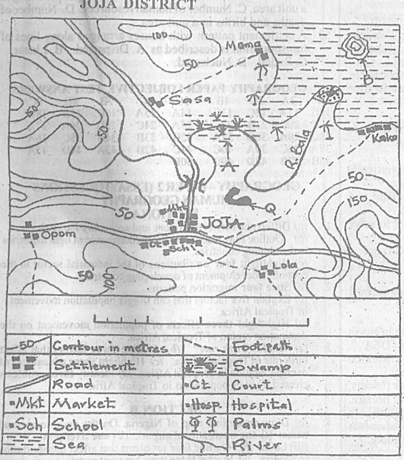
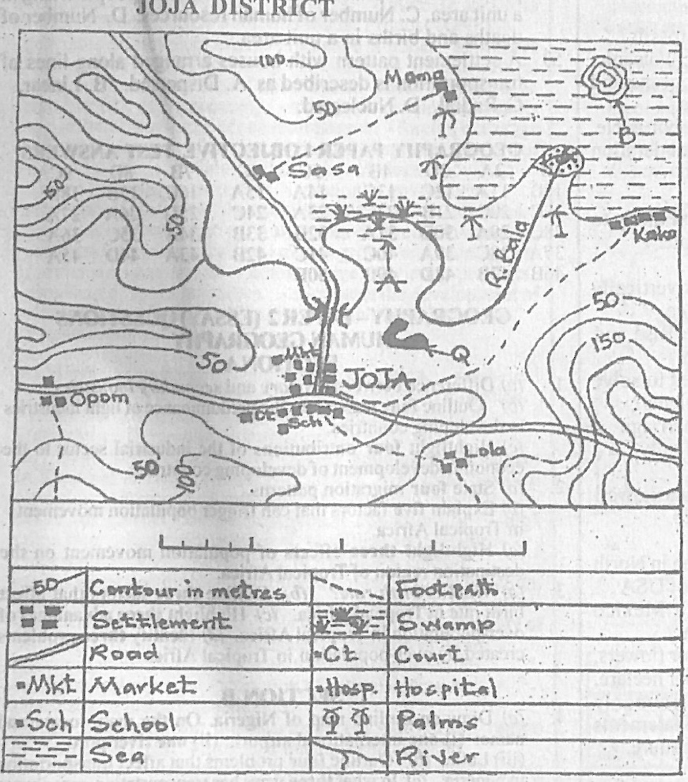
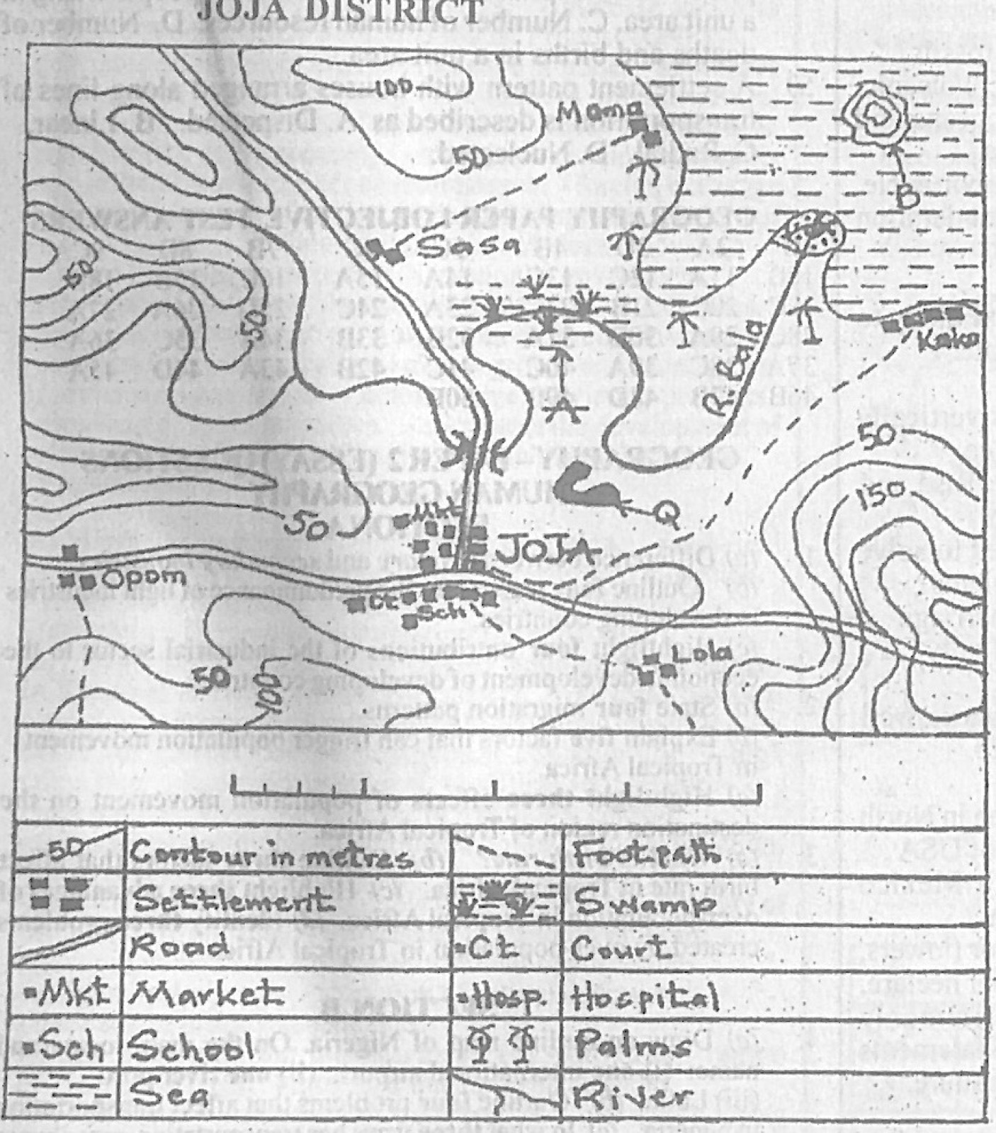
Study the map of JOJA DISTRICT to answer this question. The feature at the mouth of River Bala is likely to be a

Diagram for this question
  1. A.Waterfall.
  2. B.River capture.
  3. C.Saddle.
  4. D.Delta.
Show the answer and explanation

Answer: D (Delta.)

Explanation

Where River Bala enters the sea it ends in a fan of deposited material: a delta.

Open this question

Question 4

Map Scale, Distance and Direction

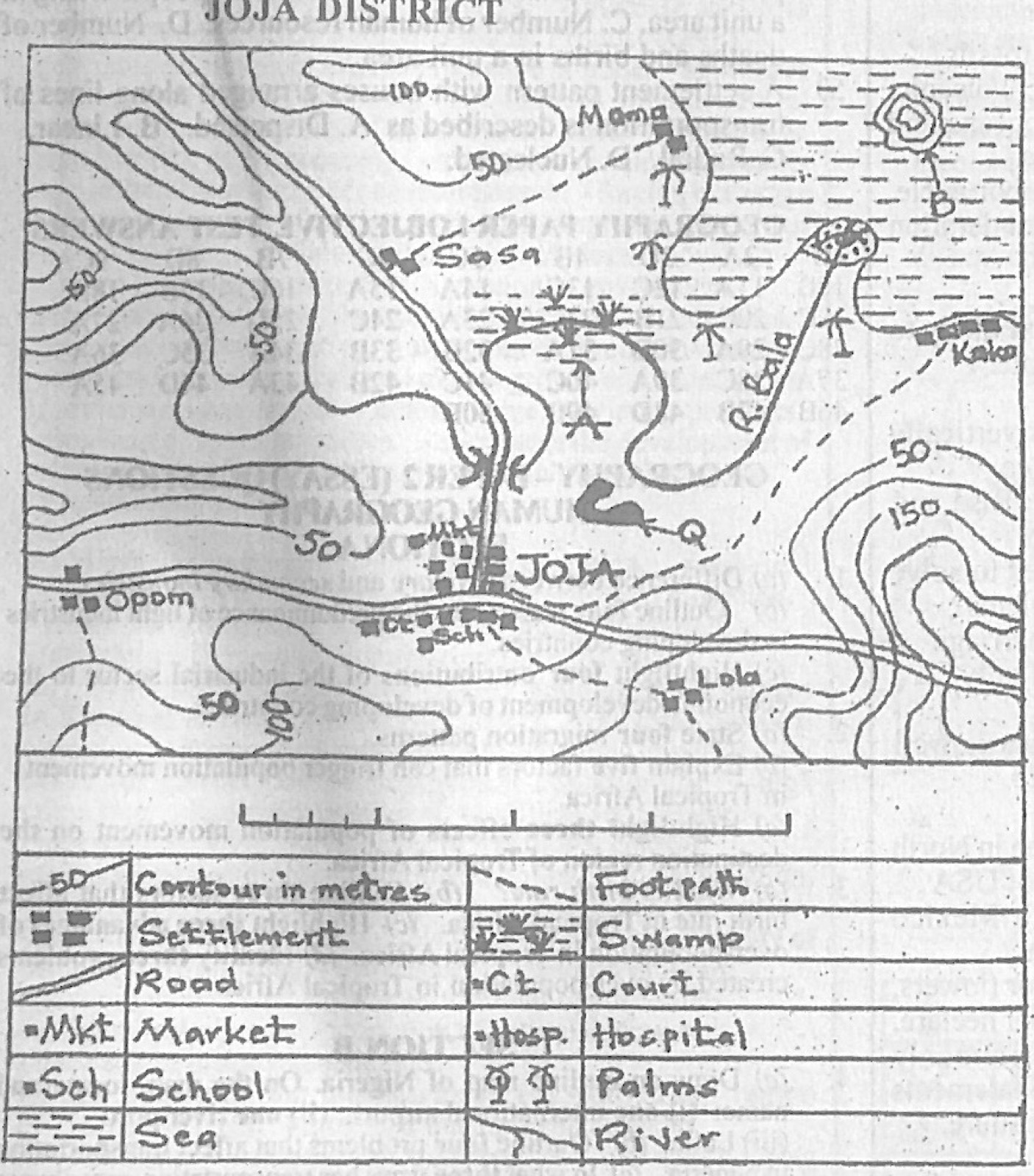
Study the map of JOJA DISTRICT to answer this question. What is the direction of Sasa from Moma?

Diagram for this question
  1. A.North east.
  2. B.South west.
  3. C.North west.
  4. D.South east.
Show the answer and explanation

Answer: B (South west.)

Explanation

Sasa lies to the left of and below Moma on the map: south-west.

Open this question

Question 7

Relief and Map Interpretation

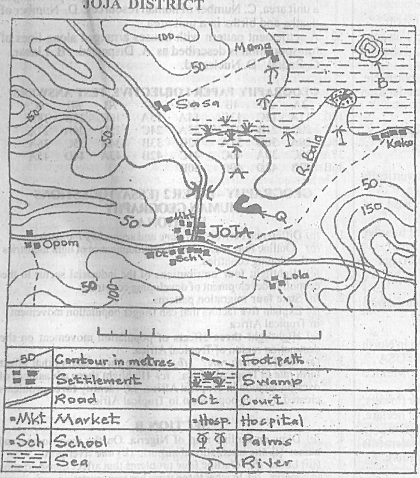
Study the map of JOJA DISTRICT to answer this question. Which part of the mapped area can coastal fishing be practiced?

Diagram for this question
  1. A.South western.
  2. B.South eastern.
  3. C.North eastern.
  4. D.North western.
Show the answer and explanation

Answer: C (North eastern.)

Explanation

The sea (with the island and the mouth of River Bala) lies in the north-east of the map, so coastal fishing is there.

Open this question

Question 8

Relief and Map Interpretation

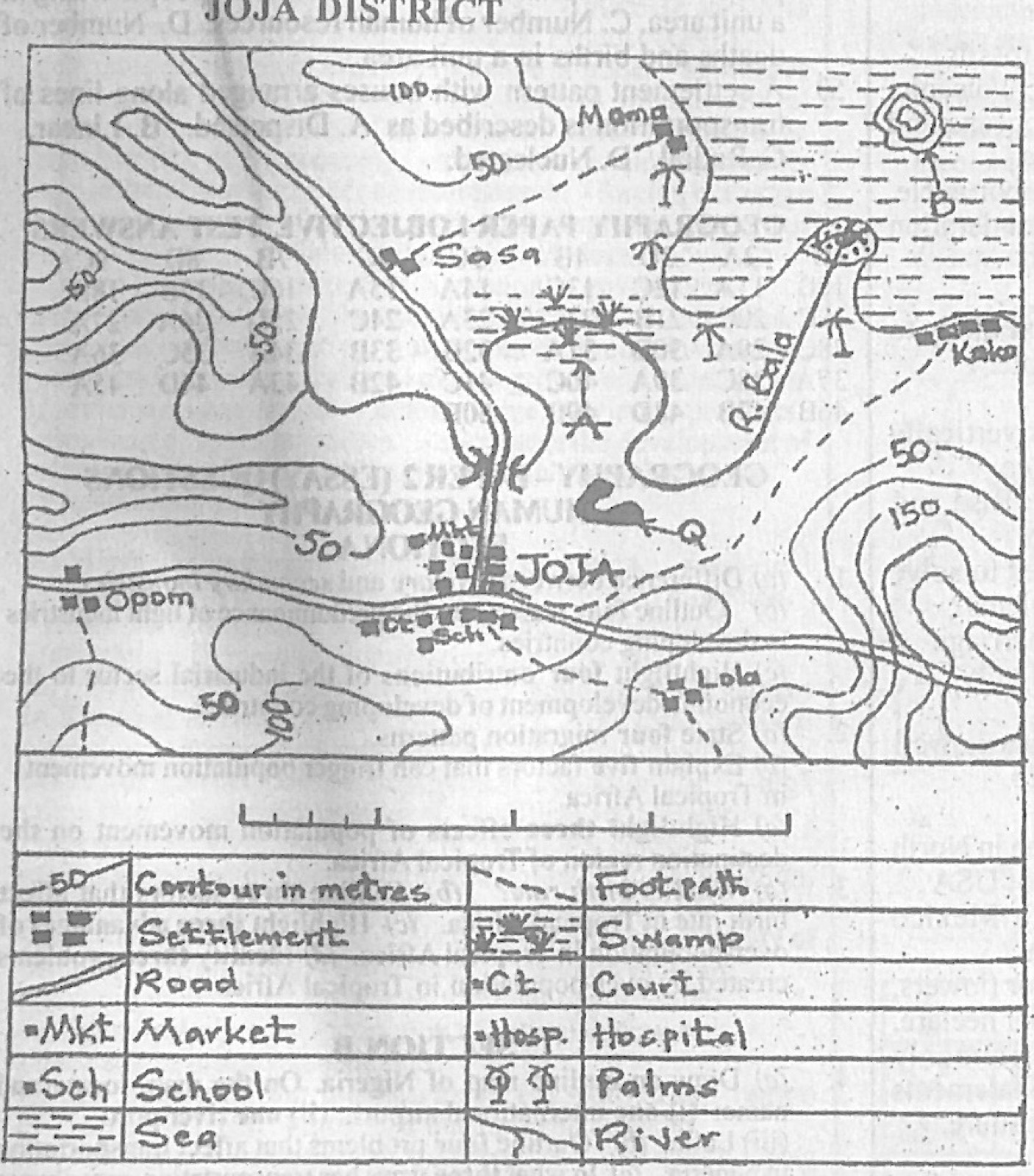
Study the map of JOJA DISTRICT to answer this question. The feature marked Q on the mapped area can be described as

Diagram for this question
  1. A.meander.
  2. B.levee.
  3. C.elbow of capture.
  4. D.ox-bow lake.
Show the answer and explanation

Answer: D (ox-bow lake.)

Explanation

Q points to a curved, horseshoe-shaped lake cut off beside the stream: an ox-bow lake.

Open this question

Question 9

Relief and Map Interpretation

Study the map of JOJA DISTRICT to answer this question. Which of the following settlements is likely to engage in fish processing?

Diagram for this question
  1. A.Lola.
  2. B.Sasa.
  3. C.Kako.
  4. D.Opom.
Show the answer and explanation

Answer: C (Kako.)

Explanation

Kako is on the coast, where fish is landed; the others are inland.

Open this question

Question 10

Map Scale, Distance and Direction

Study the map of JOJA DISTRICT to answer this question. What is the approximate bearing of Lola from Sasa?

Diagram for this question
  1. A.63°
  2. B.154°
  3. C.206°
  4. D.334°
Show the answer and explanation

Answer: B (154°)

Explanation

Lola is south-south-east of Sasa, so its bearing is between 90° and 180°: about 154°.

Open this question

Question 11

Climate

The table below shows the temperature and rainfall distribution of Station F. Use it to answer this question.
Month: Jan, Feb, Mar, Apr, May, Jun, Jul, Aug, Sep, Oct, Nov, Dec
Temperature (°C): 23, 24, 29, 34, 36, 35, 33, 31, 33, 32, 28, 23
Rainfall (mm): 0, 0, 0, 10, 108, 133, 187, 201, 187, 5, 0, 0
The annual rainfall recorded at Station F is

  1. A.831mm
  2. B.813 mm
  3. C.381 mm
  4. D.318 mm
Show the answer and explanation

Answer: A (831mm)

Explanation

0 + 0 + 0 + 10 + 108 + 133 + 187 + 201 + 187 + 5 + 0 + 0 = 831 mm.

Open this question

Question 12

Climate

The table below shows the temperature and rainfall distribution of Station F. Use it to answer this question.
Month: Jan, Feb, Mar, Apr, May, Jun, Jul, Aug, Sep, Oct, Nov, Dec
Temperature (°C): 23, 24, 29, 34, 36, 35, 33, 31, 33, 32, 28, 23
Rainfall (mm): 0, 0, 0, 10, 108, 133, 187, 201, 187, 5, 0, 0
Which of the following months is the hottest?

  1. A.January
  2. B.April
  3. C.May
  4. D.September
Show the answer and explanation

Answer: C (May)

Explanation

May has the highest temperature, 36°C.

Open this question

Question 15

Rivers and River Landforms

Which drainage pattern is best formed in areas of alternate hard and soft rocks?

  1. A.Trellised.
  2. B.Dendritic.
  3. C.Radial.
  4. D.Annular.
Show the answer and explanation

Answer: A (Trellised.)

Explanation

Streams follow the soft bands and meet the main river at right angles, giving a trellis pattern.

Open this question

Question 16

Rocks

Rocks formed through cementation of accumulated materials under water is

  1. A.Metamorphic.
  2. B.Igneous.
  3. C.Sedimentary.
  4. D.Acidic.
Show the answer and explanation

Answer: C (Sedimentary.)

Explanation

Layers of sediment laid down in water and cemented together form sedimentary rock.

Open this question

Question 17

Earth Movements and Vulcanicity

An intrusion of thick acid lava which forces overlying sedimentary rock layers to bulge into a dome may cool and solidify to form a

  1. A.Batholith.
  2. B.Laccolith.
  3. C.Dyke.
  4. D.Lopolith.
Show the answer and explanation

Answer: B (Laccolith.)

Explanation

A laccolith is a dome of viscous magma that arches the rock layers above it.

Open this question

Question 18

Climate

The Greek system of classifying climate is based on

  1. A.Temperature.
  2. B.Rainfall and temperature.
  3. C.Rainfall and vegetation.
  4. D.Humidity.
Show the answer and explanation

Answer: A (Temperature.)

Explanation

The Greeks divided the world into torrid, temperate and frigid zones according to how hot or cold they are (temperature, linked to latitude).

Open this question

Question 19

Latitude, Longitude and Time

What will be the time at Greenwich meridian when it is 12 noon at longitude 60°E?

  1. A.4.00 a.m
  2. B.4.00 p.m
  3. C.8.00 a.m
  4. D.8.00 p.m
Show the answer and explanation

Answer: C (8.00 a.m)

Explanation

60° × 4 minutes = 4 hours; Greenwich is west, so it is behind: 12 noon − 4 h = 8.00 a.m.

Open this question

Question 20

The Earth and Solar System

The movement of the earth around the sun on its elliptical orbit is called

  1. A.Rotation.
  2. B.Axis.
  3. C.Revolution.
  4. D.Gravitation.
Show the answer and explanation

Answer: C (Revolution.)

Explanation

Moving round the sun is revolution; spinning on the axis is rotation.

Open this question

Question 21

Earth Movements and Vulcanicity

The Deccan plateau in India is a good example of

  1. A.Dissected plateau.
  2. B.Volcanic plateau.
  3. C.Tectonic plateau.
  4. D.Intermontane plateau.
Show the answer and explanation

Answer: B (Volcanic plateau.)

Explanation

The Deccan was built up by sheets of basalt lava: a volcanic (lava) plateau.

Open this question

Question 22

Earth Movements and Vulcanicity

Horst is a feature associated with

  1. A.Volcanic mountain.
  2. B.Residual mountain.
  3. C.Block mountain.
  4. D.Fold mountain.
Show the answer and explanation

Answer: C (Block mountain.)

Explanation

A horst is an uplifted block between faults, i.e. a block mountain.

Open this question

Question 23

Underground Water and Karst

Which of the following pair of landforms are surface features of a karst region? I. Clint II. Grikes III. Stalagmite IV. Cavern

  1. A.I and II only
  2. B.I and III only
  3. C.II and III only
  4. D.III and IV only.
Show the answer and explanation

Answer: A (I and II only)

Explanation

Clints and grikes form the limestone pavement on the surface; stalagmites and caverns are underground.

Open this question

Question 24

Latitude, Longitude and Time

Two towns, A and B are on the International Dateline, what would be the distance between the two towns if town A is located on latitude 40°N and town B is located on latitude 10°N?

  1. A.8880 kilometres.
  2. B.5550 kilometres.
  3. C.3330 kilometres.
  4. D.2220 kilometres.
Show the answer and explanation

Answer: C (3330 kilometres.)

Explanation

They are on the same meridian: (40 − 10) = 30° × 111 km = 3,330 km.

Open this question

Question 25

Wind and Desert Landforms

Wind erosion results in the formation of the following landforms except

  1. A.Zeugen.
  2. B.Yardang.
  3. C.Ventifact.
  4. D.Barchan.
Show the answer and explanation

Answer: D (Barchan.)

Explanation

A barchan is built by wind deposition; the others are shaped by wind erosion.

Open this question

Question 26

Weathering, Erosion and Mass Movement

Which of the following best explains the breaking down of well jointed rocks into large rectangular shaped features by mechanical weathering?

  1. A.Block disintegration.
  2. B.Exfoliation dome.
  3. C.Landslide.
  4. D.Solufluction.
Show the answer and explanation

Answer: A (Block disintegration.)

Explanation

Repeated heating and cooling opens the joints and splits the rock into rectangular blocks: block disintegration.

Open this question

Question 27

Rivers and River Landforms

Which of the following conditions can produce a waterfall?

  1. A.A sharp break in the bed of a river.
  2. B.Elbow of capture of Young River.
  3. C.Backward erosion.
  4. D.Lateral erosion.
Show the answer and explanation

Answer: A (A sharp break in the bed of a river.)

Explanation

A sudden drop in the river bed (e.g. hard rock over soft, or a fault) makes the water fall vertically.

Open this question

Question 28

Coastal Landforms

Which of the following sequence is correct in the formation of a stack?

  1. A.Cave, arch, headland, stack
  2. B.Headland, cave, arch, stack
  3. C.Headland, arch, cave, stack
  4. D.Cave, headland, arch, stack
Show the answer and explanation

Answer: B (Headland, cave, arch, stack)

Explanation

Waves attack a headland, hollow out a cave, cut through it to form an arch, and the arch roof collapses to leave a stack.

Open this question

Question 29

Weathering, Erosion and Mass Movement

In which of the following regions will weathering by frost action occur throughout the year?

  1. A.Cool temperature.
  2. B.Equatorial.
  3. C.Monsoon.
  4. D.Mediterranean.
Show the answer and explanation

Answer: A (Cool temperature.)

Explanation

Frost needs temperatures that fall below freezing; only the cool temperate lands among these have this (the others are warm).

Open this question

Question 30

Weather

The normal lapse rate refers to the average rate at which

  1. A.Radiant energy is converted to heat.
  2. B.Air pressure decreases with altitude.
  3. C.Air pressure increases with altitude.
  4. D.Temperature decreases with altitude.
Show the answer and explanation

Answer: D (Temperature decreases with altitude.)

Explanation

The normal lapse rate is the fall in temperature with height, about 6.5°C per 1,000 m.

Open this question

Question 31

The Earth and Solar System

Which of the following is a proof of the earth's spherical shape?

  1. A.Circum navigation.
  2. B.Variations in the length of day and night.
  3. C.Marking of a year.
  4. D.Rise and fall of tides.
Show the answer and explanation

Answer: A (Circum navigation.)

Explanation

Ships sailing continuously in one direction return to where they started, which shows the earth is round.

Open this question

Question 32

Rocks

Which of the following types of rocks contain fossils?

  1. A.Igneous.
  2. B.Sedimentary.
  3. C.Metamorphic.
  4. D.Volcanic.
Show the answer and explanation

Answer: B (Sedimentary.)

Explanation

Remains of plants and animals are buried in layers of sediment, so fossils are found in sedimentary rocks.

Open this question

Question 33

The Ecosystem

The natural exchange of water between land, oceans and the atmosphere is known as the

  1. A.Energy cycle.
  2. B.Hydrological cycle.
  3. C.Nitrogen cycle.
  4. D.Carbon cycle.
Show the answer and explanation

Answer: B (Hydrological cycle.)

Explanation

The hydrological (water) cycle moves water by evaporation, condensation, precipitation and runoff.

Open this question

Question 34

Weather

Lines drawn on maps connecting places with equal duration of sunshine are called

  1. A.Isohels.
  2. B.Isotherms.
  3. C.Isonephs.
  4. D.Isohyets.
Show the answer and explanation

Answer: A (Isohels.)

Explanation

Isohels join places with equal sunshine.

Open this question

Question 36

The Earth and Solar System

Which of the following occurs when the sun is vertically overhead at the equator?

  1. A.Equinox
  2. B.Solstice
  3. C.Deflection of winds and ocean currents
  4. D.Rise and falls of tides.
Show the answer and explanation

Answer: A (Equinox)

Explanation

The sun is overhead at the equator at the equinoxes (21 March and 23 September).

Open this question

Question 37

Population

Which of the following pair of ways can be used to solve the world's high population concentration problems? I. Family planning. II. Sex education III. Early marriage IV. Industrialization

  1. A.I and II only
  2. B.I and III only
  3. C.II and III only
  4. D.III and IV only
Show the answer and explanation

Answer: A (I and II only)

Explanation

Family planning and sex education reduce birth rates; early marriage raises them.

Open this question

Question 38

West Africa and ECOWAS

Which of the following countries in West Africa is well known for the production of diamonds?

  1. A.Togo.
  2. B.Burkina Faso
  3. C.Sierra Leone.
  4. D.Benin.
Show the answer and explanation

Answer: C (Sierra Leone.)

Explanation

Sierra Leone is West Africa's best-known diamond producer.

Open this question

Question 39

Manufacturing Industry

Which of the following is a leading industrial area in North America?

  1. A.The North Eastern industrial area of USA
  2. B.Central Canada industrial area
  3. C.South Mexico industrial area
  4. D.The Guatemala industrial area
Show the answer and explanation

Answer: A (The North Eastern industrial area of USA)

Explanation

The north-eastern USA (manufacturing belt) is the leading industrial region of North America.

Open this question

Question 40

Agriculture, Fishing and Lumbering

'It is an intensive cultivation of fruits, vegetables or flowers, it is small scale farming, the yields are very high per hectare, produce sold to customers are usually fresh and commonly practiced in urban communities'. The above statements are characteristics of

  1. A.Mixed farming.
  2. B.Sericulture.
  3. C.Market gardening.
  4. D.Viniculture.
Show the answer and explanation

Answer: C (Market gardening.)

Explanation

Intensive growing of vegetables, fruit and flowers for nearby town markets is market gardening.

Open this question

Question 41

Population

An advantage of large population is

  1. A.Increase in government expenditure.
  2. B.Surplus employment opportunities.
  3. C.Abundant labour force.
  4. D.Small market for goods.
Show the answer and explanation

Answer: C (Abundant labour force.)

Explanation

A large population supplies plenty of workers.

Open this question

Question 42

Settlement

Which of the following best describes the relationship between rural and urban areas?

  1. A.Urban areas are not as important as rural areas.
  2. B.Urban areas and rural areas depend on each other.
  3. C.Rural areas exist only to serve urban areas.
  4. D.Urban areas can exist without rural areas.
Show the answer and explanation

Answer: B (Urban areas and rural areas depend on each other.)

Explanation

Rural areas supply food, raw materials and labour; towns supply goods, services and markets: they are interdependent.

Open this question

Question 43

Manufacturing Industry

Which of the following factors has the greatest influence on the location of cement industry?

  1. A.Proximity to source of raw materials
  2. B.Nearness to market.
  3. C.Source of capital
  4. D.Manpower development
Show the answer and explanation

Answer: A (Proximity to source of raw materials)

Explanation

Limestone is bulky and loses weight in processing, so cement factories are sited near the limestone (e.g. Ewekoro, Nkalagu).

Open this question

Question 44

Population

Which of the following best describes high population growth?

  1. A.Number of births equals number of deaths.
  2. B.Birth rates are equal to death rates.
  3. C.Emigration is equal to immigration.
  4. D.Birth rates are higher than death rates.
Show the answer and explanation

Answer: D (Birth rates are higher than death rates.)

Explanation

Population grows fast when births greatly exceed deaths.

Open this question

Question 45

Environmental Hazards and Conservation

Which of the following pairs of activities can initiate deforestation? I. Lumbering II. Afforestation III. Excavation IV. Grazing

  1. A.I and IV only
  2. B.II and III only
  3. C.II and IV only
  4. D.I and II only
Show the answer and explanation

Answer: A (I and IV only)

Explanation

Logging and overgrazing remove trees and seedlings; afforestation plants trees.

Open this question

Question 47

Settlement

Which of the following is arranged according to increasing size of settlement?

  1. A.Town, conurbation, hamlet and village
  2. B.Hamlet, village, town and conurbation
  3. C.Village, town, conurbation and hamlet
  4. D.Conurbation, town, hamlet and village
Show the answer and explanation

Answer: B (Hamlet, village, town and conurbation)

Explanation

Hamlet < village < town < conurbation.

Open this question

Question 48

Manufacturing Industry

Wood carving, leatherwork and cloth weaving are examples of

  1. A.Chemical industry.
  2. B.Power industry.
  3. C.Heavy industry.
  4. D.Local craft industry.
Show the answer and explanation

Answer: D (Local craft industry.)

Explanation

These are traditional hand-made crafts.

Open this question

Question 49

Population

Population density is defined as the average

  1. A.Number of people in the capital towns.
  2. B.Number of people living in a unit area.
  3. C.Number of human resources.
  4. D.Number of deaths and births in a unit area.
Show the answer and explanation

Answer: B (Number of people living in a unit area.)

Explanation

Density = number of people per unit area (e.g. per km²).

Open this question

Question 50

Settlement

A settlement pattern with houses arranged along lines of transportation is described as

  1. A.Dispersed.
  2. B.Linear.
  3. C.Radial.
  4. D.Nucleated.
Show the answer and explanation

Answer: B (Linear.)

Explanation

Houses strung out along a road, railway or river form a linear settlement.

Open this question

Theory question 101

Manufacturing Industry

(a) Difference between primary and secondary industries. (b) Outline four reasons for the predominance of light industries in developing countries. (c) Highlight four contributions of the industrial sector to the economic development of developing countries.

Show the model answer
Model answer

(a) Primary industries extract or produce raw materials directly from nature (farming, fishing, mining, lumbering); secondary industries process or manufacture raw materials into finished or semi-finished goods (textiles, cement, food processing).
(b) They need little capital; simple technology and less skilled labour; local raw materials are available; ready local market for consumer goods; quick returns on investment; less power needed; government encouragement of small and medium enterprises.
(c) Employment; foreign exchange earnings and savings; revenue to government; use of local raw materials and value addition; transfer of technology and skills; diversification of the economy; growth of towns and infrastructure; higher standard of living.

Explanation

Define with examples in (a).

Open this question

Theory question 102

Population

(a) State four migration patterns. (b) Explain five factors that can trigger population movement in Tropical Africa. (c) Highlight three effects of population movement on the destination region of Tropical Africa.

Show the model answer
Model answer

(a) Rural-urban; urban-rural; rural-rural; urban-urban; international migration; seasonal migration (transhumance).
(b) Search for jobs and better income; better social amenities in towns (schools, hospitals, electricity); wars, insecurity and political persecution; natural disasters (drought, floods, desertification); land shortage or poor soils; education; marriage and family reunion; trade; government resettlement schemes.
(c) Overcrowding and housing shortage; pressure on amenities and infrastructure; unemployment and crime; traffic congestion; pollution and slums; larger labour force and market; cultural mixing and diffusion of ideas.

Explanation

Explain push and pull factors.

Open this question

Theory question 103

Population

(a) What is birth rate? (b) Outline three factors that affect birth rate in Tropical Africa. (c) Highlight three advantages of over-population in Tropical Africa. (d) Identify three problems created by over-population in Tropical Africa.

Show the model answer
Model answer

(a) Birth rate is the number of live births per 1,000 people in a population in one year.
(b) Early marriage; polygamy; desire for many children (labour, prestige, security in old age); low use of family planning; religious and cultural beliefs; low level of female education; improved health care for mothers.
(c) Large labour force; large market for goods; manpower for defence; more taxpayers; encourages investment and full use of resources.
(d) Unemployment; food shortage and malnutrition; housing shortage and slums; pressure on social amenities; high crime rate; environmental degradation; high dependency ratio.

Explanation

Define birth rate per 1,000.

Open this question

Theory question 104

Nigeria: People and Economy

(a) Draw an outline map of Nigeria. On the map, locate and name: (i) one international airport; (ii) one river port; (iii) Lafia. (b) Outline four problems that affect transportation in Nigeria. (c) In what three ways has transportation contributed to the economic development of Nigeria?

Show the model answer
Model answer

(a) Outline of Nigeria with title and north arrow; an international airport such as Murtala Muhammed (Lagos), Nnamdi Azikiwe (Abuja), Mallam Aminu Kano (Kano) or Port Harcourt; a river port such as Onitsha, Lokoja, Baro or Makurdi; Lafia in Nasarawa State in central Nigeria.
(b) Bad roads and poor maintenance; inadequate funds; insecurity (robbery, kidnapping); difficult terrain and floods; high cost of vehicles, fuel and spare parts; poor management; accidents; old rail system.
(c) Moves people and goods easily; promotes internal and international trade; opens up new areas and links production and markets; creates employment; earns revenue; promotes national unity; supports growth of towns and tourism.

Explanation

Name real places on the map.

Open this question

Theory question 105

Nigeria: People and Economy

(a) Outline five factors which determine what can be produced in Nigeria. (b) Idenfity five factors that hinder in Nigeria.

Show the model answer
Model answer

(a) Climate (rainfall, temperature); soil and relief; availability of natural resources and raw materials; capital; labour and skills; technology; market demand; power supply; transport; government policy; political stability.
(b) (trade) Poor transport and communication; inadequate capital and high interest rates; multiple taxes and tolls; insecurity; poor storage facilities; low purchasing power; inflation and fluctuating prices; smuggling; inconsistent government policy; poor quality and packaging of goods; competition from imported goods.

Explanation

Read (b) as factors that hinder trade.

Open this question

Theory question 106

Nigeria: Physical Setting

(a) Draw an outline map of Nigeria. On the map, show and name: (i) longitude 15°E; (ii) Udi Hill; (iii) Lokoja. (b) Outline three importance of highlands in Nigeria. (c) Identify four development problems arising from the presence of highlands in Nigeria.

Show the model answer
Model answer

(a) Outline of Nigeria with title and north arrow; longitude 15°E as a line near the eastern border (through the Lake Chad area); Udi Hill (Udi Plateau) in the south-east near Enugu; Lokoja at the Niger-Benue confluence.
(b) Source of minerals (tin and columbite on Jos Plateau, coal at Udi); source of rivers; cause relief rainfall; cool climate for tourism and resorts; grazing land; sites for HEP; defence; special crops (e.g. Irish potatoes on Jos Plateau).
(c) Barrier to road and rail construction; high cost of building infrastructure; soil erosion on steep slopes; difficult farming and mechanisation; scattered settlements; rain shadow on leeward sides; landslides; inaccessibility.

Explanation

Mark longitude 15°E clearly.

Open this question

Theory question 302

Statistical Maps and Diagrams

The Table G below shows the value of commodities exported by a country in the year 2020. Study and use it to answer the questions that follow.
Table G
Cocoa: 729 US dollars
Diamond: 400
Gold: 900
Crude oil: 196
(a) Using a radius scale of 1 cm to represent 10 units, draw proportional circles to represent the value of exported commodities by the country in the year 2020. [Use the square root method] (b) Calculate the percentage of the value of gold exported in the year 2020.

Show the model answer
Model answer

(a) Square roots: cocoa √729 = 27 → radius 2.7 cm; diamond √400 = 20 → 2.0 cm; gold √900 = 30 → 3.0 cm; crude oil √196 = 14 → 1.4 cm. Draw four circles with these radii, label each with the commodity and value, and add a title and the scale.
(b) Total = 729 + 400 + 900 + 196 = 2,225; gold = 900 ÷ 2,225 × 100 ≈ 40.4%.

Explanation

Take square roots before scaling.

Open this question

Theory question 303

Wind and Desert Landforms

(a) List three processes of wind erosion. (b) With the aid of a diagram, describe the characteristics and mode of formation of a zeugen.

Show the model answer
Model answer

(a) Deflation; abrasion (corrasion); attrition.
(b) Diagram: tabular ridges of hard rock capping soft rock, separated by deep furrows. Characteristics: ridge-and-furrow landscape; flat tops of hard rock; steep sides; furrows up to about 30 m deep; found in deserts. Formation: horizontal layers of hard rock lie over soft rock; joints in the hard cap are widened by weathering (e.g. frost or temperature change); wind abrasion then cuts down into the soft rock beneath, deepening the furrows; the hard rock remains as tabular blocks (zeugen) and may be undercut.

Explanation

Mention hard over soft layers.

Open this question

Theory question 304

Rocks

(a) What is an igneous rocks? (b) State three characteristics of igneous rocks. (c) Explain five economic importance of igneous rocks.

Show the model answer
Model answer

(a) Igneous rocks are rocks formed from the cooling and solidification of molten magma or lava.
(b) Crystalline; hard and compact; not in layers (unstratified); no fossils; mostly impermeable; may be acidic (granite) or basic (basalt).
(c) Building stone and road chippings (granite); sources of minerals (gold, tin, copper, iron); weather to fertile soils (volcanic soils); tourist attractions (inselbergs, volcanic features); granite and basalt for monuments and ornaments; contain groundwater in joints; geothermal energy in volcanic areas.

Explanation

Give an example for each importance.

Open this question

Theory question 305

Underground Water and Karst

(a) State three conditions that favour the development of Karst topography. (b) Describe the characteristics and mode of formation of sink hole.

Show the model answer
Model answer

(a) A thick bed of hard, well-jointed limestone at or near the surface; moderate to heavy rainfall; water table well below the surface; limestone not too porous; plenty of carbon dioxide in rainwater.
(b) Characteristics: a funnel-shaped hole on the surface of limestone; water from surface streams disappears into it; may lead to underground caves; some are large and deep. Formation: rainwater containing carbon dioxide (weak carbonic acid) dissolves limestone along joints; the joints are widened at their intersections; continued solution enlarges the opening into a funnel-shaped hole; roof collapse of caves may also form sink holes.

Explanation

Mention carbonation-solution.

Open this question

Theory question 306

Climate

(a) Using Koppen's System of classification of climates, identify the types of climate that are represented by the letters listed below: (i) Af; (ii) Am; (iii) Aw. (b) Outline six characteristics of the Af climate.

Show the model answer
Model answer

(a)(i) Af: tropical rainforest (equatorial) climate; (ii) Am: tropical monsoon climate; (iii) Aw: tropical savanna (wet and dry) climate.
(b) High temperature (about 27°C) all year; small annual range (2-3°C); heavy rainfall over 2,000 mm; rain in every month (no dry season); double maxima; convectional rain with thunderstorms in the afternoon; high relative humidity; cloudy skies; small diurnal range.

Explanation

Six distinct characteristics.

Open this question

Theory question 307

Rivers and River Landforms

(a) List three features that can be found in the middle course of a river. (b) Describe the characteristics and mode of formation of pothole.

Show the model answer
Model answer

(a) Meanders; river cliffs and slip-off slopes; bluffs; small flood plains; open V-shaped valley; confluences; tributaries.
(b) Characteristics: round, cylindrical holes in the rocky bed of a river; found in the upper course; sizes from a few cm to several metres; often contain pebbles. Formation: pebbles and boulders are trapped in hollows of the river bed; the swirling current (eddies) spins them round; they grind the rock by abrasion (drilling action); the hollow is deepened and widened into a pothole; worn pebbles are replaced by new ones.

Explanation

Describe the drilling action of pebbles.

Open this question

Theory question 308

Environmental Resources

(a) Define atmospheric resources. (b) Outline three importance of atmospheric resources. (c) Highlight three human activities that adversely affect the composition of the atmosphere.

Show the model answer
Model answer

(a) Atmospheric resources are the useful components of the atmosphere (gases such as oxygen, nitrogen and carbon dioxide, water vapour, sunlight and wind) that people and other living things use.
(b) Oxygen for breathing; carbon dioxide for photosynthesis; nitrogen for plants and industry (fertilizers); rainfall from water vapour; wind and solar energy; ozone layer protects from ultraviolet rays; regulates temperature.
(c) Burning of fossil fuels in vehicles, factories and generators; gas flaring; bush burning and deforestation; use of CFCs (aerosols, refrigerants); mining and quarrying dust; burning of refuse.
Explanation

Name the gas and its use.

Open this question