WAEC Geography 2023 past questions and answers

52 questions. Try each one, then open the answer to check yourself and read the explanation.

Question 2

Relief and Map Interpretation

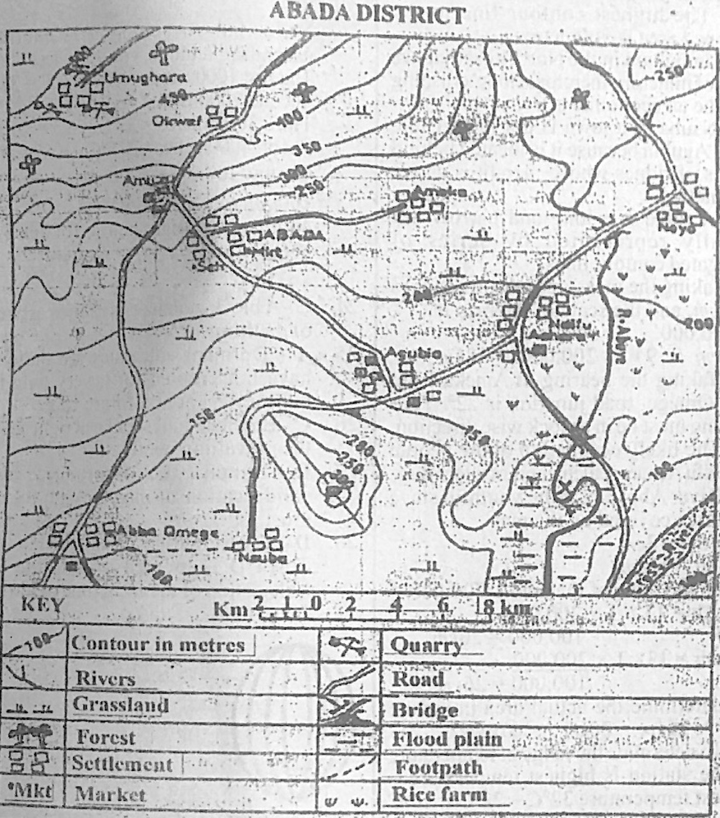
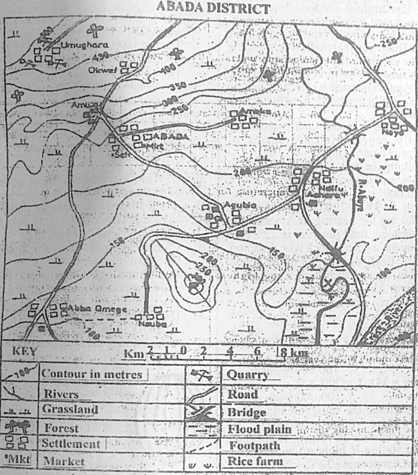
Study the map of ABADA DISTRICT to answer this question. What is the highest contour line in the mapped area?

Diagram for this question
  1. A.600 metres
  2. B.500 metres
  3. C.400 metres
  4. D.300 metres
Show the answer and explanation

Answer: B (500 metres)

Explanation

The highest labelled contour, near Umughara in the north-west, is 500 m.

Open this question

Question 3

Relief and Map Interpretation

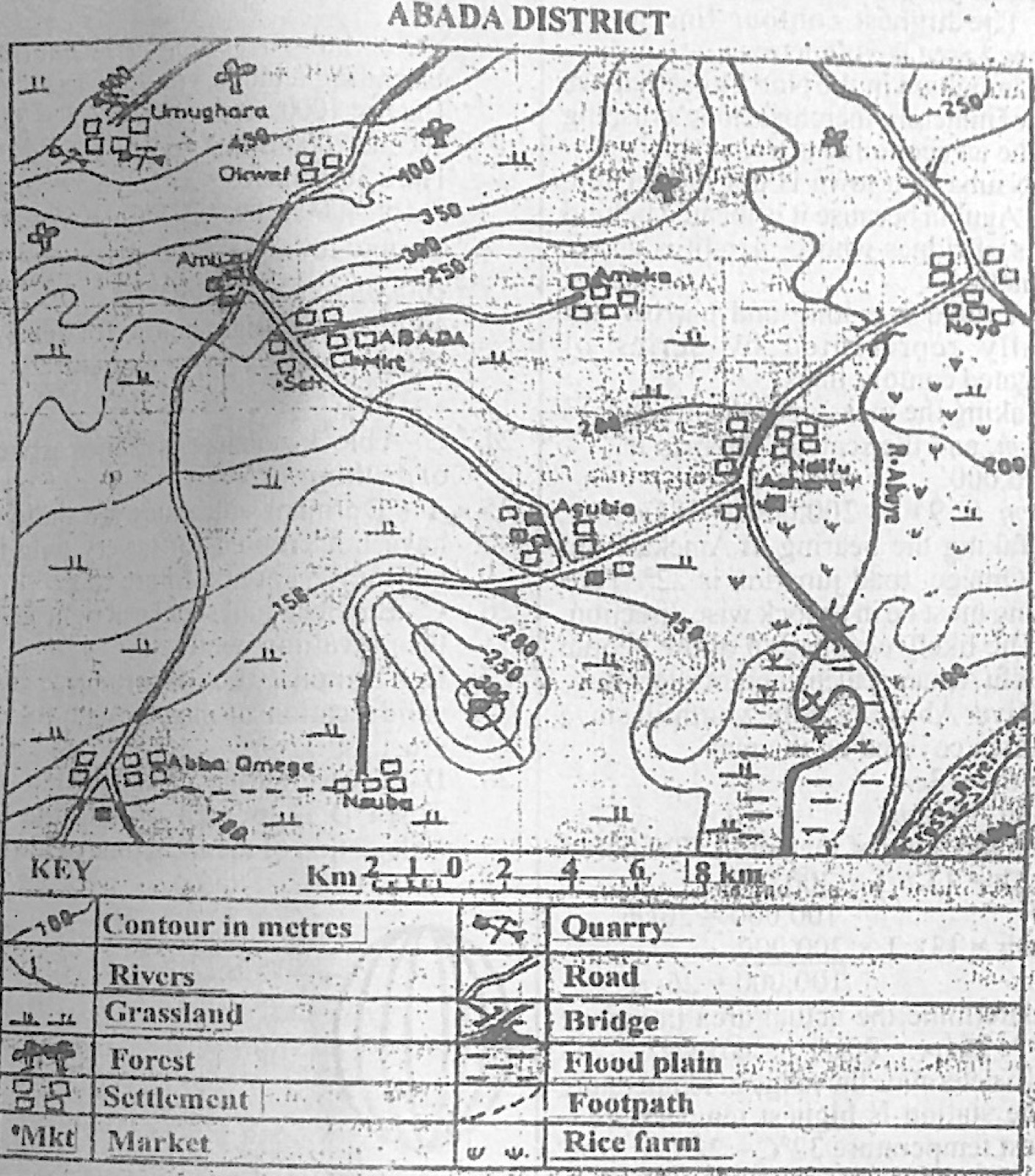
Study the map of ABADA DISTRICT to answer this question. Stone crushing is an economic activity at

Diagram for this question
  1. A.Agubia.
  2. B.Noyo.
  3. C.Umughara.
  4. D.Ameka.
Show the answer and explanation

Answer: C (Umughara.)

Explanation

The quarry symbol is beside Umughara, so stone is quarried and crushed there.

Open this question

Question 4

Relief and Map Interpretation

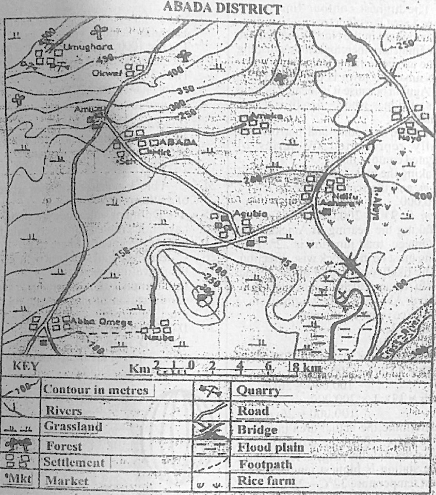
Study the map of ABADA DISTRICT to answer this question. Which of the following towns is not intervisible from Agubia?

Diagram for this question
  1. A.Ameka
  2. B.ABADA
  3. C.Ndifu Achara
  4. D.Nsuba
Show the answer and explanation

Answer: D (Nsuba)

Explanation

Nsuba lies south of the hill rising above 300 m, which blocks the view from Agubia.

Open this question

Question 7

Map Scale, Distance and Direction

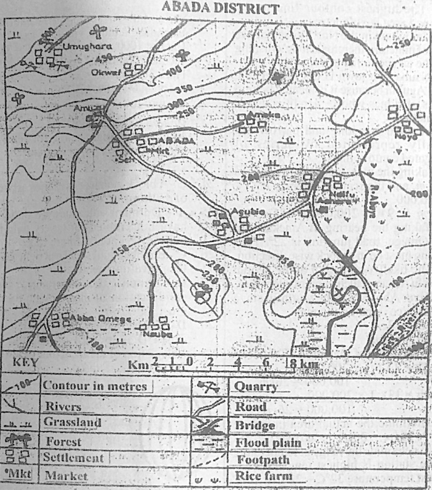
Study the map of ABADA DISTRICT to answer this question. The bearing of Ameka from Aba Omege road junction is approximately

Diagram for this question
  1. A.22°
  2. B.40°
  3. C.90°
  4. D.220°
Show the answer and explanation

Answer: B (40°)

Explanation

Ameka lies north-east of the junction near Aba Omege; measured clockwise from north the angle is about 45°, nearest 40°.

Open this question

Question 8

Relief and Map Interpretation

Study the map of ABADA DISTRICT to answer this question. The likely occupation of the people of Ndifu Achara settlement is

Diagram for this question
  1. A.rice farming.
  2. B.trading.
  3. C.gold mining.
  4. D.lumbering.
Show the answer and explanation

Answer: A (rice farming.)

Explanation

Rice farm symbols surround Ndifu Achara on the river's flood plain.

Open this question

Question 11

Climate

The table below shows the temperature and rainfall distribution of Station Z. Use it to answer this question.
Month: Jan, Feb, Mar, Apr, May, Jun, Jul, Aug, Sep, Oct, Nov, Dec
Temperature (°C): 22, 25, 29, 32, 31, 28, 27, 26, 27, 27, 26, 23
Rainfall (mm): 0, 3, 3, 13, 64, 122, 208, 307, 140, 13, 0, 0
What is the annual range of temperature for Station Z?

  1. A.10°C
  2. B.22°C
  3. C.32°C
  4. D.54°C
Show the answer and explanation

Answer: A (10°C)

Explanation

Highest 32°C (April) − lowest 22°C (January) = 10°C.

Open this question

Question 12

Climate

The table below shows the temperature and rainfall distribution of Station Z. Use it to answer this question.
Month: Jan, Feb, Mar, Apr, May, Jun, Jul, Aug, Sep, Oct, Nov, Dec
Temperature (°C): 22, 25, 29, 32, 31, 28, 27, 26, 27, 27, 26, 23
Rainfall (mm): 0, 3, 3, 13, 64, 122, 208, 307, 140, 13, 0, 0
Which month of the year has the highest temperature?

  1. A.May
  2. B.June
  3. C.August
  4. D.April
Show the answer and explanation

Answer: D (April)

Explanation

April has the highest temperature, 32°C.

Open this question

Question 13

Climate

The table below shows the temperature and rainfall distribution of Station Z. Use it to answer this question.
Month: Jan, Feb, Mar, Apr, May, Jun, Jul, Aug, Sep, Oct, Nov, Dec
Temperature (°C): 22, 25, 29, 32, 31, 28, 27, 26, 27, 27, 26, 23
Rainfall (mm): 0, 3, 3, 13, 64, 122, 208, 307, 140, 13, 0, 0
The wettest month of the year is

  1. A.May.
  2. B.July.
  3. C.August.
  4. D.September.
Show the answer and explanation

Answer: C (August.)

Explanation

August has the most rain, 307 mm.

Open this question

Question 14

The Earth and Solar System

Which of the following distinguishes rotation from revolution?

  1. A.The earth rotates on its axis while it revolves round the sun on an elliptical orbit.
  2. B.Revolution causes day and night while rotation causes season.
  3. C.A complete revolution takes 24 hours while rotation marks a year.
  4. D.Rotation causes variation in the lengths of day and night while revolution causes rising and falling of tides.
Show the answer and explanation

Answer: A (The earth rotates on its axis while it revolves round the sun on an elliptical orbit.)

Explanation

Rotation is spinning on the axis (one day); revolution is moving round the sun in an elliptical orbit (one year).

Open this question

Question 15

Mining and Energy

The type of energy that is most environmentally friendly is

  1. A.hydroelectric.
  2. B.solar.
  3. C.thermal.
  4. D.nuclear.
Show the answer and explanation

Answer: B (solar.)

Explanation

Solar energy produces no smoke, waste or flooding of land; it is clean and renewable.

Open this question

Question 17

Earth Movements and Vulcanicity

Which of the following landforms is associated with parallel faulting?

  1. A.Dyke
  2. B.Inselberg
  3. C.Gorge
  4. D.Rift Valley
Show the answer and explanation

Answer: D (Rift Valley)

Explanation

A rift valley forms when the block between two parallel faults sinks.

Open this question

Question 18

Weather

The instrument used to measure relative humidity is called

  1. A.hygrometer.
  2. B.barometer.
  3. C.anemometer.
  4. D.thermometer.
Show the answer and explanation

Answer: A (hygrometer.)

Explanation

The hygrometer (wet and dry bulb) measures relative humidity.

Open this question

Question 19

The Earth and Solar System

The sun is vertically overhead at the Tropic of Capricorn on

  1. A.March 21st.
  2. B.September 23rd.
  3. C.December 22nd.
  4. D.June 21st.
Show the answer and explanation

Answer: C (December 22nd.)

Explanation

At the December solstice (22 December) the overhead sun is at 23½°S.

Open this question

Question 20

Wind and Desert Landforms

Which of the following pairs of landforms can be found in the desert areas?

  1. A.Yardangs and batholiths
  2. B.Sandbars and tombolos
  3. C.Zeugens and rock pedestals
  4. D.Barchans and tombolos
Show the answer and explanation

Answer: C (Zeugens and rock pedestals)

Explanation

Zeugens and rock pedestals are both carved by wind in deserts.

Open this question

Question 21

Structure of the Earth

The part of the earth crust covered by water bodies is known as the

  1. A.sial.
  2. B.stratosphere.
  3. C.hydrosphere.
  4. D.atmosphere.
Show the answer and explanation

Answer: C (hydrosphere.)

Explanation

The hydrosphere is all the water on the earth: oceans, seas, lakes and rivers.

Open this question

Question 22

Latitude, Longitude and Time

The distance between town A located on latitude 30° S and town B located on latitude 30°N is

  1. A.3330 km.
  2. B.6660 km.
  3. C.9000 km
  4. D.9770 km.
Show the answer and explanation

Answer: B (6660 km.)

Explanation

They are on opposite sides of the equator: 30 + 30 = 60° × 111 km = 6,660 km.

Open this question

Question 23

Weather

What is the temperature around an aeroplane flying at an altitude of 4000 metres if the temperature on the earth surface is 40°C?

  1. A.12°C
  2. B.14°C
  3. C.26°C
  4. D.66°C
Show the answer and explanation

Answer: B (14°C)

Explanation

Temperature falls 6.5°C per 1,000 m: 4 × 6.5 = 26°C; 40 − 26 = 14°C.

Open this question

Question 24

Earth Movements and Vulcanicity

A block mountain is formed as a result of

  1. A.differential erosion.
  2. B.vulcanicity.
  3. C.faulting.
  4. D.fissure.
Show the answer and explanation

Answer: C (faulting.)

Explanation

Block mountains are raised between faults.

Open this question

Question 25

Earth Movements and Vulcanicity

Volcanoes that have not erupted for a very long time but may erupt at a future time are termed as

  1. A.dormant.
  2. B.active.
  3. C.extrusive.
  4. D.intrusive.
Show the answer and explanation

Answer: A (dormant.)

Explanation

A dormant ('sleeping') volcano is inactive now but may erupt again.

Open this question

Question 26

Wind and Desert Landforms

Barchan dunes move

  1. A.in the same direction as the prevailing winds.
  2. B.against the prevailing winds.
  3. C.at right angle to the prevailing wind.
  4. D.in a circular direction.
Show the answer and explanation

Answer: A (in the same direction as the prevailing winds.)

Explanation

Wind pushes sand up the gentle windward slope and over the crest, so the whole barchan creeps forward in the direction the wind blows, with its horns pointing downwind.

Open this question

Question 27

Rocks

Which of the following rocks is produced by the solidification of magma within the earth crust?

  1. A.Metamorphic rock
  2. B.Sedimentary rock
  3. C.Extrusive rock
  4. D.Plutonic rock
Show the answer and explanation

Answer: D (Plutonic rock)

Explanation

Magma that cools slowly deep in the crust forms plutonic (intrusive) rocks such as granite.

Open this question

Question 28

Latitude, Longitude and Time

Town C is located on latitude 15°E while Town D is located on latitude 60°E. If the local time in Town C is 7.00am., what will be the local time in Town D?

  1. A.4.00 p.m.
  2. B.4.00 a.m.
  3. C.10.00 p.m.
  4. D.10.00 a.m.
Show the answer and explanation

Answer: D (10.00 a.m.)

Explanation

45° difference × 4 minutes = 180 minutes = 3 hours; D is further east so it is ahead: 7.00 am + 3 h = 10.00 am.

Open this question

Question 31

Wind and Desert Landforms

Which of the following is a wind deposited landform?

  1. A.Loess
  2. B.Rock pedestal
  3. C.Deflation hollow
  4. D.Yardang
Show the answer and explanation

Answer: A (Loess)

Explanation

Loess is fine dust carried and deposited by wind; the others are wind-erosion features.

Open this question

Question 32

Weathering, Erosion and Mass Movement

When weathering occurs on hillslopes, rock debris usually pile up at the bottom of the hill slope to form

  1. A.creep.
  2. B.pebbles.
  3. C.screes.
  4. D.levee.
Show the answer and explanation

Answer: C (screes.)

Explanation

Broken rock fragments collecting at the foot of a slope form scree (talus).

Open this question

Question 33

Weather

A smaller range of temperature is recorded along the coast than the continental interior on the same latitudes because of the

  1. A.higher insolation inland.
  2. B.higher evaporation inland.
  3. C.moderating influence of the sea.
  4. D.thicker vegetation on the coast.
Show the answer and explanation

Answer: C (moderating influence of the sea.)

Explanation

The sea warms and cools slowly, keeping coastal temperatures even.

Open this question

Question 34

Latitude, Longitude and Time

Which of the following is an important line of longitude?

  1. A.Tropic of Cancer
  2. B.Antarctic Circle
  3. C.Arctic Circle
  4. D.Prime Meridian
Show the answer and explanation

Answer: D (Prime Meridian)

Explanation

The Prime (Greenwich) Meridian, 0°, is a line of longitude; the others are lines of latitude.

Open this question

Question 35

Rivers and River Landforms

Which of the following features is associated with the upper course of a river?

  1. A.Waterfall
  2. B.Meander
  3. C.Delta
  4. D.Levee
Show the answer and explanation

Answer: A (Waterfall)

Explanation

Waterfalls form where a fast young river crosses hard rock in its upper course.

Open this question

Question 37

Transport, Trade and Tourism

Which of the following factors is a major boost to tourism?

  1. A.Adequate publicity about natural scenery
  2. B.Higher dependency ratio of the population
  3. C.Specialization in labour force
  4. D.Variation in mode of transportation
Show the answer and explanation

Answer: A (Adequate publicity about natural scenery)

Explanation

Tourists come when attractive scenery is well advertised.

Open this question

Question 38

Agriculture, Fishing and Lumbering

Which of the following is not a plantation crop?

  1. A.Rubber
  2. B.Oil Palm
  3. C.Cocoa
  4. D.Rye
Show the answer and explanation

Answer: D (Rye)

Explanation

Rye is a temperate cereal grown on ordinary farms; rubber, oil palm and cocoa are plantation crops.

Open this question

Question 39

West Africa and ECOWAS

The sparse population in the middle belt of West Africa can be traced to all the following except

  1. A.inter-ethnic war.
  2. B.Arab slave trade in the north.
  3. C.tsetse fly infestation.
  4. D.concentration of industries.
Show the answer and explanation

Answer: D (concentration of industries.)

Explanation

Wars, slave raids and tsetse flies drove people away; industries would attract people.

Open this question

Question 40

Manufacturing Industry

The main reason for which most manufacturing industries in West Africa are concentrated in cities and towns along the coast is that they have

  1. A.a large pool of unskilled labour.
  2. B.large urban market.
  3. C.numerous banks.
  4. D.a large number of warehouses.
Show the answer and explanation

Answer: B (large urban market.)

Explanation

Coastal cities have many people with money to buy goods, so firms locate near this market (and the ports).

Open this question

Question 41

Population

The most common form of migration experienced in countries of Tropical Africa is

  1. A.urban-urban migration.
  2. B.rural-rural migration.
  3. C.urban-rural migration.
  4. D.rural-urban migration.
Show the answer and explanation

Answer: D (rural-urban migration.)

Explanation

Most migrants move from villages to towns in search of jobs and amenities.

Open this question

Question 42

Transport, Trade and Tourism

Great Britain and Germany are trading partners of West African countries from

  1. A.Western Europe.
  2. B.North America.
  3. C.South America.
  4. D.The Far East.
Show the answer and explanation

Answer: A (Western Europe.)

Explanation

Both countries are in Western Europe.

Open this question

Question 43

Manufacturing Industry

Which of the following is a feature of heavy industries?

  1. A.Small scale plants
  2. B.Capital intensive
  3. C.Low turn-over
  4. D.Consumer goods production
Show the answer and explanation

Answer: B (Capital intensive)

Explanation

Heavy industries need huge investment in plant and machinery: they are capital intensive.

Open this question

Question 44

Settlement

Which of the following criteria is used to classify settlements into rural or urban?

  1. A.Age
  2. B.Site
  3. C.Function
  4. D.Location
Show the answer and explanation

Answer: C (Function)

Explanation

Rural settlements perform mainly primary functions, urban ones secondary and tertiary functions.

Open this question

Question 45

Population

What is the population density of a country with a total population of 140,000,000 and a total land area of 500,000 km²?

  1. A.200 persons per km²
  2. B.280 persons per km²
  3. C.350 persons per km²
  4. D.500 persons per km²
Show the answer and explanation

Answer: B (280 persons per km²)

Explanation

140,000,000 ÷ 500,000 = 280 persons per km².

Open this question

Question 46

Transport, Trade and Tourism

Which of the following is not a problem facing transportation development in Tropical Africa?

  1. A.Difficult terrain
  2. B.Inadequate capital
  3. C.Poor planning
  4. D.Climatic variation
Show the answer and explanation

Answer: D (Climatic variation)

Explanation

Difficult terrain, shortage of capital and poor planning are the major problems; climatic variation is the least direct of the four.

Open this question

Question 48

Mining and Energy

More Hydroelectric Power projects should be constructed in Tropical Africa because

  1. A.there are absence of waterfalls on rivers.
  2. B.skilled labour is scarce.
  3. C.there is scanty rainfall.
  4. D.there is an increasing demand for power.
Show the answer and explanation

Answer: D (there is an increasing demand for power.)

Explanation

Demand for electricity is rising fast with population and industry.

Open this question

Question 49

Transport, Trade and Tourism

Buying and selling of goods and services within a country is termed as

  1. A.international trade.
  2. B.internal trade.
  3. C.barter trade.
  4. D.foreign trade.
Show the answer and explanation

Answer: B (internal trade.)

Explanation

Trade within one country's borders is internal (home) trade.

Open this question

Question 50

Settlement

A major function performed by rural settlement is

  1. A.industrial.
  2. B.administrative
  3. C.agricultural.
  4. D.commercial
Show the answer and explanation

Answer: C (agricultural.)

Explanation

Most rural people are farmers, so agriculture is the main rural function.

Open this question

Theory question 101

Manufacturing Industry

(a) Identify five problems affecting industrial growth in developing countries. (b) Suggest five measures that can promote the growth of industries in developing countries.

Show the model answer
Model answer

(a) Inadequate capital; erratic power supply; shortage of skilled labour and technology; poor transport and infrastructure; inadequate or irregular raw materials; small home market/low purchasing power; competition from imported goods; political instability and insecurity; high taxes and inconsistent policies; poor management and corruption.
(b) Provide credit and industrial development banks; improve power supply; train technical manpower; build roads, railways and other infrastructure; use local raw materials and encourage research; protect infant industries (tariffs, bans on some imports); tax holidays and incentives; stable government and good policies; security.

Explanation

Each measure should answer a problem.

Open this question

Theory question 102

Settlement

(a) Outline five characteristics of rural settlements in Tropical Africa. (b) In what five ways does rural settlement depend on urban settlement?

Show the model answer
Model answer

(a) Small population; mainly primary activities (farming, fishing, lumbering); few social amenities; dispersed or linear layout with no planning; houses built of local materials; homogeneous people with strong traditions; poor roads and communication; simple, quiet life.
(b) Market for farm produce; supply of manufactured goods and farm inputs; jobs for rural people; higher-order services (hospitals, banks, higher education); administrative headquarters; source of new ideas and information; remittances and investment from town dwellers.

Explanation

Five points for each part.

Open this question

Theory question 103

Transport, Trade and Tourism

Describe rail transportation in Tropical Africa under the following headings: (a) four advantages; (b) three problems affecting rail transportation; (c) one solution to each of the problems stated in 3 (b).

Show the model answer
Model answer

(a) Cheap for bulky goods over long distances; carries heavy loads (minerals, crops); fairly safe; little affected by weather; no traffic congestion; opens up the interior.
(b) Narrow gauge and single tracks; old locomotives and slow speed; poor maintenance and shortage of spare parts; inadequate funding; poor management; competition from road transport; vandalism and insecurity.
(c) Change to standard gauge and double tracks; buy modern locomotives; regular maintenance and local fabrication of parts; more funding and private participation; better management and training; security patrols and punishment of vandals.

Explanation

Pair each solution with its problem.

Open this question

Theory question 104

Transport, Trade and Tourism

(a) What is internal trade? (b) Outline five problems limiting internal trade in Nigeria. (c) Identify four importance of internal trade in Nigeria.

Show the model answer
Model answer

(a) Internal trade is the buying and selling of goods and services within the borders of a country.
(b) Poor roads and transport; insecurity (robbery, kidnapping); multiple taxes and road blocks; poor storage and preservation facilities; inadequate capital and credit; similarity of products in many areas; poor communication and market information; low purchasing power; inflation and unstable prices.
(c) Brings goods from areas of surplus to areas of need; encourages specialisation in production; creates jobs; raises government revenue; promotes growth of towns and markets; promotes national unity and exchange of ideas.

Explanation

Define first, then list.

Open this question

Theory question 105

Nigeria: Physical Setting

(a) Draw a sketch map of Nigeria. On the map, locate and name: (i) the Sudan savanna belt; (ii) the Tropical rainforest belt; (iii) one town in 5 (a) (ii). (b) Identify four characteristics of the Tropical rainforest in Nigeria. (c) Outline five economic importance of the Tropical rainforest to Nigeria.

Show the model answer
Model answer

(a) Outline of Nigeria with title, key and north arrow; Sudan savanna as a belt across the north (Sokoto, Kano, Katsina); tropical rainforest as a belt across the south, north of the coastal swamps; a rainforest town such as Benin City, Ibadan, Akure, Onitsha or Calabar.
(b) Tall evergreen trees (up to 60 m) in three layers (canopy); many species mixed together; hardwoods (mahogany, obeche, iroko); dense undergrowth, climbers and epiphytes; buttress roots; little light reaches the floor.
(c) Timber for building and export; raw materials for industries (paper, furniture, plywood); fuel wood and charcoal; cash crops grown there (cocoa, oil palm, rubber); medicinal plants and food (fruits, bush meat); tourism; employment; protects soil and water catchments.

Explanation

Give named tree species.

Open this question

Theory question 106

Nigeria: Physical Setting

(a) Draw a sketch map of Nigeria. On the map, locate and name: (i) River Benue; (ii) River Sokoto; (iii) Makurdi. (b) Outline three characteristics of rivers in Nigeria. (c) In what four ways are rivers useful in Nigeria?

Show the model answer
Model answer

(a) Outline of Nigeria with title and north arrow; River Benue entering from Cameroon in the east and joining the Niger at Lokoja; River Sokoto in the north-west flowing into the Niger; Makurdi on the River Benue.
(b) Volume varies with seasons (floods in the rainy season, low in the dry season); many have rapids and waterfalls; the Niger and Benue are the main rivers and most others drain into them or into the Atlantic; northern rivers drain into Lake Chad (inland drainage); many carry much silt; some dry up in the dry season.
(c) Hydroelectric power (Kainji, Jebba, Shiroro); water for irrigation and domestic use; fishing; inland water transport; boundaries; tourism and recreation (Argungu festival); sand for building; fertile flood plains for farming.

Explanation

Four uses with examples.

Open this question

Theory question 302

Climate

The Table below shows the temperature and rainfall distribution of Station X. Study and use it to answer the questions that follow.
Month: Jan, Feb, Mar, Apr, May, Jun, Jul, Aug, Sep, Oct, Nov, Dec
Temperature (°C): 25, 27, 32, 34, 35, 33, 29, 28, 28, 29, 28, 25
Rainfall (mm): 0, 0, 0, 0, 15, 99, 211, 211, 142, 48, 8, 5
(a) Identify the type of climate represented by Station X. (b) From which hemisphere was the climatic figures taken? Support your answer with one reason. (c) Outline four characteristics of the rainfall recorded at Station X. (d) Calculate the mean annual temperature for Station X.

Show the model answer
Model answer

(a) Tropical continental (Sudan/savanna) climate.
(b) Northern hemisphere: the rainy season and highest temperatures come in the middle of the year (May-September) and the coolest months are December-January.
(c) Total about 739 mm, fairly low; single maximum (peak in July-August); rain falls in about seven or eight months and there is a long dry season (November-April); rain is mostly convectional, in heavy showers; rainfall is unevenly distributed through the year.
(d) Sum = 25 + 27 + 32 + 34 + 35 + 33 + 29 + 28 + 28 + 29 + 28 + 25 = 353°C; mean = 353 ÷ 12 ≈ 29.4°C.

Explanation

Show the sum before dividing.

Open this question

Theory question 303

The Earth and Solar System

(a) List the four seasons of the year. (b) Outline two differences between standard time and local time. (c) With the aid of a diagram, describe the formation of solar eclipse.

Show the model answer
Model answer

(a) Spring; summer; autumn; winter.
(b) Local time is the time of a place based on the sun's position on its own meridian (noon when the sun is highest), standard time is the time adopted for a whole country or time zone; local time changes by 4 minutes for every degree of longitude, standard time changes in whole hours (15°); local time differs from place to place within a country, standard time is the same throughout a zone.
(c) Diagram: sun, moon and earth in a straight line with the moon in the middle, umbra and penumbra on the earth. The moon revolves round the earth; at new moon it sometimes passes directly between the sun and the earth; it blocks the sun's light and casts a shadow on part of the earth; places in the umbra see a total eclipse, places in the penumbra a partial eclipse; it lasts only a few minutes.

Explanation

The moon is in the middle for a solar eclipse.

Open this question

Theory question 304

Underground Water and Karst

(a) List: (i) three surface features of a limestone region; (ii) four underground features of a limestone region. (b) Outline four benefits of limestone region.

Show the model answer
Model answer

(a)(i) Swallow holes (sinkholes); dolines; uvalas; poljes; clints and grikes (limestone pavement); dry valleys; gorges.
(ii) Caves and caverns; stalactites; stalagmites; pillars (columns); underground rivers and lakes.
(b) Raw material for cement; lime for agriculture and industry; building stone; tourist attractions (caves); grazing land; underground water supply; marble from metamorphosed limestone.

Explanation

Separate surface from underground features.

Open this question

Theory question 305

Rivers and River Landforms

(a) List three processes of river transportation. (b) State four characteristics associated with the middle course of a river. (c) With the aid of a diagram, describe the mode of formation of interlocking spurs.

Show the model answer
Model answer

(a) Traction; saltation; suspension; solution.
(b) Gentler gradient than the upper course; wider, open V-shaped valley; lateral erosion becomes important; meanders begin to form; more volume of water from tributaries; deposition begins, forming small flood plains; river cliffs and slip-off slopes.
(c) Diagram: plan of a winding river between alternating spurs. In the upper course the river cuts downward rapidly (vertical erosion); it is too small and weak to erode sideways, so it winds round areas of harder rock; the projecting ridges (spurs) on alternate sides overlap one another and appear to lock together, so one cannot see far up the valley.

Explanation

Stress vertical erosion.

Open this question

Theory question 307

Weathering, Erosion and Mass Movement

(a) What is weathering? (b) Explain the following processes of mechanical weathering: (i) frost action; (ii) exfoliation.

Show the model answer
Model answer

(a) Weathering is the breaking down and decay of rocks in their original place by physical, chemical and biological processes.
(b)(i) Frost action: water fills cracks in rock; at night it freezes and expands; the pressure widens the cracks; repeated freezing and thawing splits off angular fragments (scree).
(ii) Exfoliation: in hot deserts rocks heat strongly by day and cool quickly at night; the outer layer expands and contracts more than the inside; stresses create cracks parallel to the surface; outer shells peel off like onion skins, leaving rounded rocks.

Explanation

Mention heating and cooling for exfoliation.

Open this question

Theory question 308

Mining and Energy

(a) What is solar energy? (b) Outline three advantages of solar energy. (c) Highlight three problems associated with harnessing of solar energy.

Show the model answer
Model answer

(a) Solar energy is energy from the sun's radiation (light and heat), which can be converted into electricity or heat by solar panels and collectors.
(b) Renewable and inexhaustible; clean, no pollution; available almost everywhere, good for remote areas; low running cost; quiet.
(c) High initial cost of panels and batteries; low output at night and in cloudy or dusty weather; needs storage; needs large areas for panels; shortage of skilled technicians; theft of panels.
Explanation

Advantages and problems as short phrases.

Open this question