58 questions. Try each one, then open the answer to check yourself and read the explanation.
Question 2
Map Scale, Distance and Direction
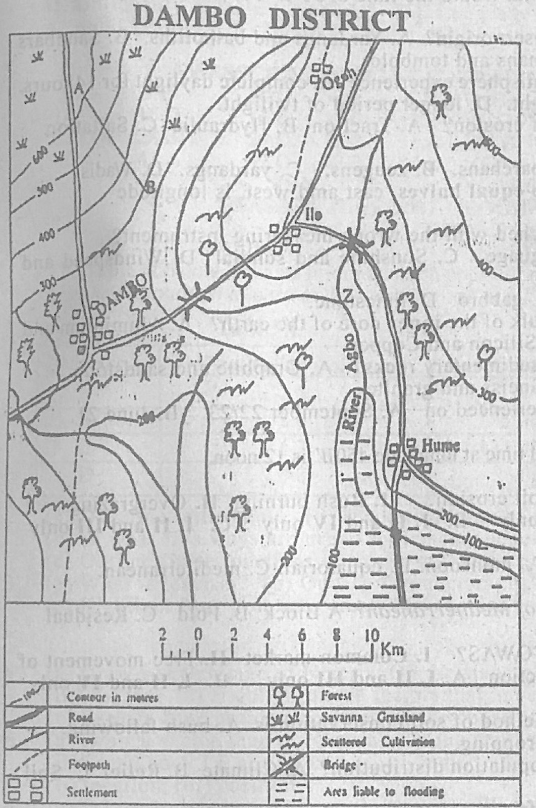
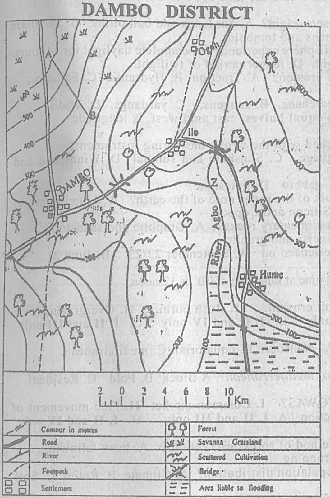
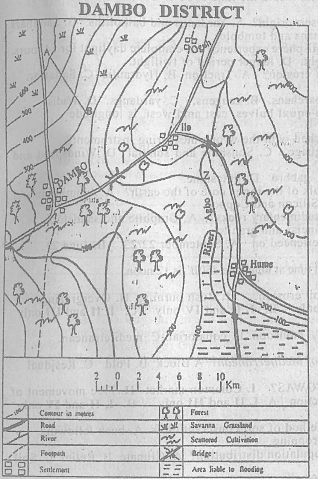
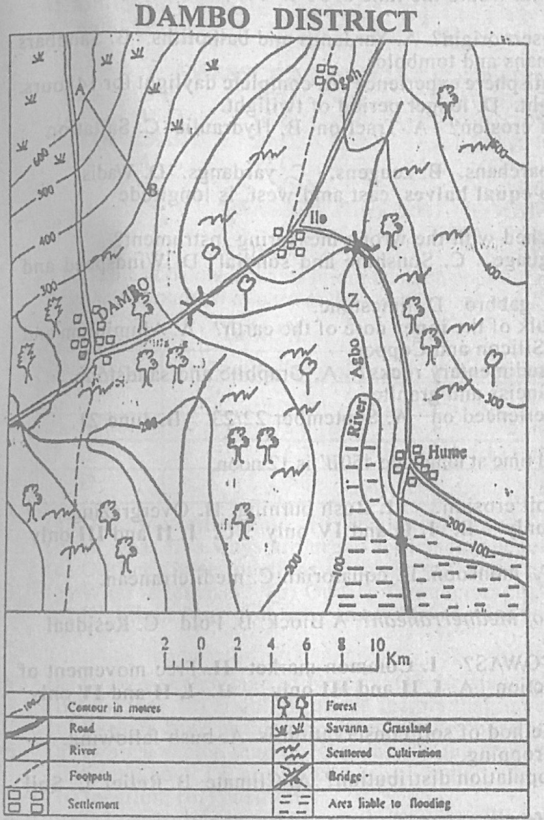
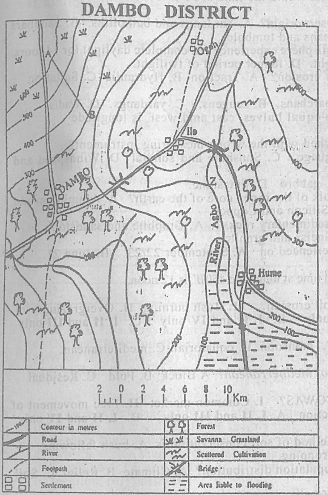
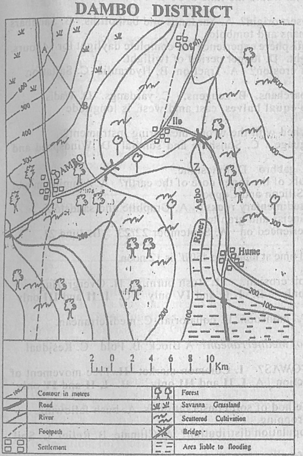
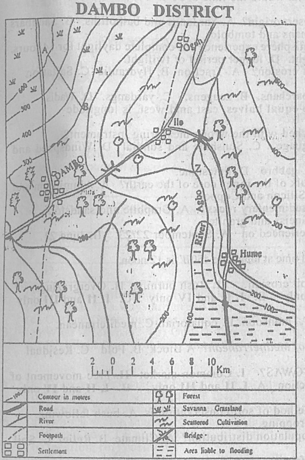
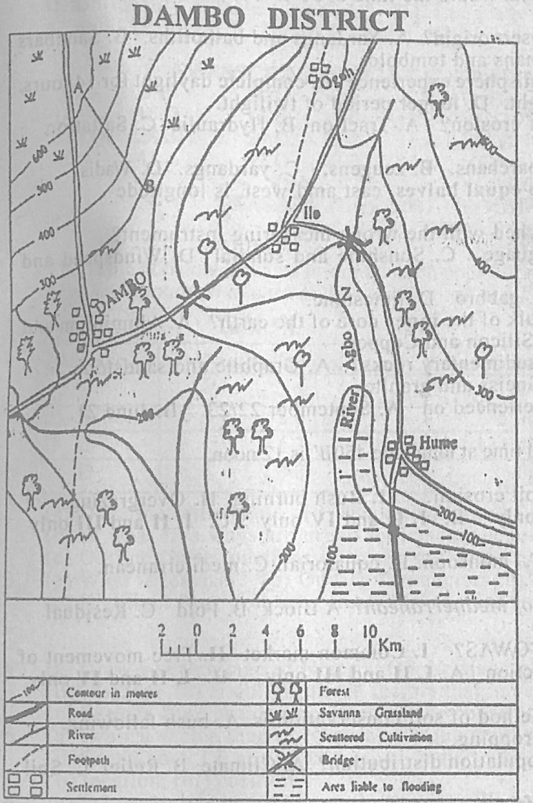
Study the map of DAMBO DISTRICT to answer this question. What is the approximate distance between the settlements of DAMBO and Hume by road?
A.10 km.
B.15 km.
C.20 km.
D.30 km.
Show the answer and explanation
Answer: D (30 km.)
Explanation
Follow the road from Dambo north-east to the junction near Ilo, then south to Hume and measure against the linear scale: about 17 km + 14 km, roughly 30 km.
Use the climatic data of Station X to answer this question. Month: Jan, Feb, Mar, Apr, May, Jun, Jul, Aug, Sep, Oct, Nov, Dec Temperature (°C): 16, 20, 22, 23, 25, 28, 28, 30, 27, 26, 23, 21 Rainfall (mm): 62, 50, 56, 89, 180, 189, 140, 163, 228, 230, 83, 41 Which month in the station has the highest rainfall?
Use the climatic data of Station X to answer this question. Month: Jan, Feb, Mar, Apr, May, Jun, Jul, Aug, Sep, Oct, Nov, Dec Temperature (°C): 16, 20, 22, 23, 25, 28, 28, 30, 27, 26, 23, 21 Rainfall (mm): 62, 50, 56, 89, 180, 189, 140, 163, 228, 230, 83, 41 What is the annual rainfall for Station X?
Use the climatic data of Station X to answer this question. Month: Jan, Feb, Mar, Apr, May, Jun, Jul, Aug, Sep, Oct, Nov, Dec Temperature (°C): 16, 20, 22, 23, 25, 28, 28, 30, 27, 26, 23, 21 Rainfall (mm): 62, 50, 56, 89, 180, 189, 140, 163, 228, 230, 83, 41 Calculate the range of temperature for the station.
Use the climatic data of Station X to answer this question. Month: Jan, Feb, Mar, Apr, May, Jun, Jul, Aug, Sep, Oct, Nov, Dec Temperature (°C): 16, 20, 22, 23, 25, 28, 28, 30, 27, 26, 23, 21 Rainfall (mm): 62, 50, 56, 89, 180, 189, 140, 163, 228, 230, 83, 41 Which of the following statements is true about rainfall in Station X?
A.The rainfall duration is six months.
B.The station has a double maxima rainfall
C.Rain mainly falls in winter
D.The rainfall in the station is uniformly distributed over the months
Show the answer and explanation
Answer: B (The station has a double maxima rainfall)
Explanation
Rainfall rises to a peak in June (189 mm), dips in July (140 mm) and rises to a second peak in September-October: two maxima.
The temperature reading at the peak of a volcano is 6°C. What will be the temperature at the foot of the volcano which is 3000 metres from the surrounding low land?
A.5.5°C
B.13.5°C
C.25.5°C
D.35.5°C
Show the answer and explanation
Answer: C (25.5°C)
Explanation
Temperature falls about 6.5°C per 1,000 m, so 3,000 m gives 19.5°C; at the foot it is 6 + 19.5 = 25.5°C.
Which of the following are achievements of the ECOWAS? I. Common market II. Free movement of people III. Military cooperation IV. Trade restriction
A.I, II and III only
B.I, II and IV only
C.II, III and IV only
D.I, III and IV only.
Show the answer and explanation
Answer: A (I, II and III only)
Explanation
ECOWAS has worked towards a common market, allowed free movement of people and set up ECOMOG for joint military action; restricting trade is not an aim.
Which of the following are characteristics of most large cities? They I. have large plantations. II. are administrative centres. III. are religious centres. IV. are commercial centres.
A.I and III only.
B.I and IV only.
C.II and III only.
D.II and IV only.
Show the answer and explanation
Answer: D (II and IV only.)
Explanation
Large cities are usually centres of government and of trade; plantations are rural and not all cities are religious centres.
Cities of high population densities develop on plains because they I. act as climatic barriers II. have fertile soils. III. lack heavy rainfall. IV. have terrain with ease of communication.
A.I and II only
B.I and III only
C.I and IV only
D.II and IV only
Show the answer and explanation
Answer: D (II and IV only)
Explanation
Plains usually have fertile soils and are easy to build roads and railways across, so people concentrate there.
The reason for siting industries in urban areas include I. employment II. revenue generation. III. religious tolerance IV. unemployment provision.
A.I and II only.
B.II and IV only.
C.III and IV only.
D.I and IV only.
Show the answer and explanation
Answer: A (I and II only.)
Explanation
Industries in towns provide jobs and bring revenue to government; religious tolerance has nothing to do with it and 'unemployment provision' is not a benefit.
Which of the following factors explain the need for international trade? I. Variation in technology II. Uniformity in taste for goods. III. Language barrier. IV. Differences in natural resources.
A.I and II only
B.II and III only
C.II and IV only
D.I and IV only.
Show the answer and explanation
Answer: D (I and IV only.)
Explanation
Countries trade because they have different resources and different levels of technology; uniform tastes and language barriers do not create trade.
The Table X below contains information on population of four districts of country Z in the year 2016. Use the information to answer the questions which follow. Table X District A: population 5.5 million; land area 60,000 km² District B: population 8.0 million; land area 105,000 km² District C: population 6.7 million; land area 125,000 km² District D: population 4.8 million; land area 88,000 km² (a) Calculate the: (i) total population of country Z; (ii) total land area of country Z; (iii) population density of country Z. (b) State four factors which are responsible for high population density of countries. (c) Explain three advantages associated with countries of high population density.
Show the model answer
Model answer
(a)(i) 5.5 + 8.0 + 6.7 + 4.8 = 25 million (25,000,000). (ii) 60,000 + 105,000 + 125,000 + 88,000 = 378,000 km². (iii) Density = population ÷ area = 25,000,000 ÷ 378,000 ≈ 66 persons per km². (b) Fertile soils and good farmland; favourable climate; availability of water; gentle relief; mineral resources and industries (jobs); good transport and accessibility; social amenities; political stability and security; high birth rate and low death rate; administrative or commercial centres. (c) Large labour force for farms and industries; large home market for goods, which attracts investors; cheaper provision of roads, schools and other services per person; more taxpayers and revenue for government; manpower for defence; full use of resources; rapid spread of ideas and innovation.
(a)(i) Define settlement: (ii) Name two types of urban settlement classified according to population size. (b) In what five ways are urban settlements dependent on rural settlements? (c) Outline three functions of urban settlements.
Show the model answer
Model answer
(a)(i) A settlement is a place where people live, a building or group of buildings together with the people who live and work there. (ii) Town; city; conurbation; metropolis; megalopolis (any two). (b) Rural areas supply food; raw materials for urban industries (cotton, cocoa, timber); labour (migrants); building materials (sand, gravel, timber); fuel wood and charcoal; market for manufactured goods; recreation and tourist sites; herbs and craft products. (c) Administrative centres; commercial/market centres; industrial centres; educational centres; health services; transport nodes and ports; religious and cultural centres; residential function.
(a) What is tourism? (b) Outline five factors that favour the development of tourism. (c) Highlight four problems created by tourism industry in developing countries.
Show the model answer
Model answer
(a) Tourism is the travel of people away from their usual home to other places for pleasure, leisure or business, staying for at least one night and less than a year. (b) Attractive scenery and natural features (beaches, waterfalls, mountains); wildlife parks and game reserves; historical and cultural sites and festivals; good transport and accessibility; good accommodation (hotels); political stability and security; pleasant climate; publicity and favourable government policy; friendly, hospitable people. (c) Erosion of local culture and values; social vices (drug abuse, prostitution) and crime; pollution and damage to the environment and historic sites; rising prices of goods and land; spread of diseases; seasonal unemployment; profits going to foreign companies; poaching of wildlife.
(a) Draw a sketch map of Nigeria. On the map, locate and name: (i) the Kainji dam; (ii) Lake Chad; (iii) Ibadan. (b) Highlight three factors that impede the development of solar energy in Nigeria. (c) Explain four problems created by the construction of the Kainji dam in Nigeria.
Show the model answer
Model answer
(a) Outline of Nigeria with a title, north arrow and key; Kainji dam on the River Niger in the west (Niger State/Kwara area, about 10°N 4.5°E); Lake Chad in the extreme north-east corner; Ibadan in the south-west, north-east of Lagos. (b) High cost of solar panels and batteries; lack of technical skills; low level of technology and dependence on imported parts; poor maintenance; inadequate government policy and funding; low public awareness; theft and vandalism of panels; cloud cover and harmattan dust reduce sunshine. (c) Displacement and resettlement of people from flooded villages; loss of farmland and grazing land; loss of forest and wildlife habitats; spread of water-borne diseases (bilharzia, malaria); reduced flow and silt downstream, affecting farming and fishing; flooding when water is released; loss of historical sites (old Bussa); high cost of maintenance.
(a) Draw a sketch map of Nigeria. On the map, show and name: (i) Latitudes 4°N and 14°N; (ii) Longitudes 3°E and 15°E; (iii) Enugu. (b) Describe Nigeria under the following headings: (i) size; (ii) location; (iii) position.
Show the model answer
Model answer
(a) Outline of Nigeria with title and north arrow; latitude 4°N along the southern coast and 14°N along the northern border; longitude 3°E on the western border and 15°E near the eastern border; Enugu in the south-east. (b)(i) Size: about 923,768 km²; about 1,100 km from north to south and about 1,300 km from east to west; the most populous country in Africa; one of the largest countries in West Africa (about one-seventh of the region). (ii) Location: in West Africa; between latitudes 4°N and 14°N and longitudes 3°E and 15°E; north of the equator and east of the Greenwich meridian; extent about 10° of latitude and 12° of longitude. (iii) Position: bounded by the Niger Republic in the north, Chad in the north-east, Cameroon in the east, Benin Republic in the west and the Atlantic Ocean (Gulf of Guinea) in the south; surrounded by French-speaking countries.
(a)(i) List four industrial towns in Nigeria. (ii) Indicate one type of industrial activity in each of the towns listed in 6(a)(i). (b) Outline three contributions of industries to the economic development of Nigeria. (c) Identify three problems which are limiting industrial development in Nigeria.
Show the model answer
Model answer
(a)(i)-(ii) e.g. Lagos - textiles, breweries, food processing; Port Harcourt - oil refining and petrochemicals; Kano - tanning, leather and groundnut oil milling; Kaduna - oil refining and textiles; Aba - soap, footwear and textiles; Nkalagu - cement; Jos - tin smelting; Onitsha - textiles and plastics. (b) Provide employment; earn foreign exchange; raise revenue for government; add value to raw materials; transfer technology and skills; diversify the economy; encourage growth of towns and infrastructure; reduce imports. (c) Erratic power supply; shortage of capital; shortage of skilled labour; poor transport and infrastructure; competition from imported goods; insecurity; high cost of raw materials and spare parts; inconsistent government policies and corruption.
The Table X below contains data on the distribution of Groundnut production in four regions of country M in the year 2013. Use the data in the table to answer the questions that follow. Table X Country A: 100,000 metric tonnes Country B: 260,000 metric tonnes Country C: 200,000 metric tonnes Country D: 80,000 metric tonnes (a) Using the map of country M and a scale of one dot to represent 20,000 metric tonnes, produce dots to represent the data. (b) State three disadvantages of dot maps.
Show the model answer
Model answer
(a) Number of dots = production ÷ 20,000: A = 5 dots; B = 13 dots; C = 10 dots; D = 4 dots. Copy the outline of Country M with regions A-D, place dots of equal size evenly in each region, and add a title and key (1 dot = 20,000 metric tonnes). (b) Exact values are hard to read off; fractions of the dot value cannot be shown; dots crowd together and merge in high-value areas; spreading dots evenly hides the real distribution within a region; choosing a suitable dot value is difficult; dots may fall on areas where the crop is not grown (lakes, hills); slow to draw.
(a) List three landforms associated with coastal erosion. (b) Explain the following processes of wave erosion: (i) hydraulic action; (ii) corrasion.
Show the model answer
Model answer
(a) Cliff; wave-cut platform; cave; arch; stack; stump; headland and bay; geo; blowhole. (b)(i) Hydraulic action: waves hit the coast with great force; water and air are forced into cracks and joints; the air is compressed, then expands suddenly as the wave retreats; repeated pressure widens the cracks and breaks off pieces of rock. (ii) Corrasion (abrasion): waves pick up sand, pebbles and boulders and hurl them against the cliff base; they act as tools that scrape and undercut the rock, forming notches and wave-cut platforms.
Explain how the following factors affect the temperature of a place: (a) altitude; (b) distance from the sea; (c) Slope and aspect.
Show the model answer
Model answer
(a) Temperature falls with height at about 6.5°C per 1,000 m; the atmosphere is heated from the ground by terrestrial radiation, so air further from the ground is cooler; air at height is thinner and holds less heat; so highland places (e.g. Jos Plateau) are cooler than lowlands. (b) Land heats and cools faster than the sea; the sea warms places near it in winter and cools them in summer; coastal places have a small annual and daily range (maritime climate); inland places have hot summers, cold winters and a large range (continental climate). (c) Slopes facing the sun (south-facing in the northern hemisphere) receive direct rays and are warmer; slopes facing away are in shade and cooler; gentle slopes may collect cold air in valleys at night (temperature inversion).
(a) What is a Great Circle? (b) Outline three characteristics of a Great Circle. (c) If the time at longitude 100°E was 5 a.m. on Monday, 11th April 2011, what was the: (i) time at longitude 10°W (ii) day at longitude 10°W (iii) date at longitude 10°W?
Show the model answer
Model answer
(a) A great circle is a circle on the earth's surface whose plane passes through the centre of the earth, dividing it into two equal halves. (b) It divides the earth into two hemispheres; its centre is the centre of the earth; it is the largest circle that can be drawn on the globe; the shortest distance between two points lies along a great circle (used by ships and aircraft); all meridians and the equator are great circles; infinitely many can be drawn. (c) Difference = 100 + 10 = 110°; 110 × 4 = 440 minutes = 7 h 20 min; 10°W is west, so time is behind: 5.00 a.m. − 7 h 20 min = 9.40 p.m. (i) 9.40 p.m.; (ii) Sunday; (iii) 10th April 2011.
(a) List three types of sedimentary rocks classified according to their mode of formation. (b) Name the rocks that are formed when the following undergo metamorphism: (i) granite; (ii) clay; (iii) shale; (iv) limestone (c) Outline four differences between sedimentary and metamorphic rocks.
Show the model answer
Model answer
(a) Mechanically formed (clastic) rocks, e.g. sandstone, shale; organically formed rocks, e.g. limestone, coal, chalk; chemically formed rocks, e.g. rock salt, gypsum, potash. (b)(i) Granite - gneiss; (ii) clay - slate; (iii) shale - slate (or schist); (iv) limestone - marble. (c) Sedimentary rocks are formed from deposited sediments, metamorphic rocks from existing rocks changed by heat and/or pressure; sedimentary rocks are in layers (strata), metamorphic rocks are banded or foliated; sedimentary rocks may contain fossils, metamorphic rocks rarely do; sedimentary rocks are usually soft and porous, metamorphic rocks hard, compact and non-porous; sedimentary rocks form at the surface, metamorphic rocks deep in the crust.
(a) List three landforms that are associated with extrusive volcanic action. (b) With the aid of a diagram, describe the characteristics and mode of formation of laccolith.
Show the model answer
Model answer
(a) Volcanic cones (ash, cinder, composite); lava plateau; lava plain; crater; caldera; crater lake; geysers and hot springs; fumaroles. (b) Diagram: a dome-shaped mass of solidified magma between rock layers, with a pipe feeding it from below and the overlying layers arched upwards. Characteristics: intrusive feature; dome or mushroom shape with a flat base; lies between bedding planes; arches the overlying strata; may be exposed by erosion as a hill (e.g. Henry Mountains, USA). Formation: viscous magma rises along a line of weakness; it cannot spread far or break through the overlying hard layers; it accumulates between strata and forces the upper layers to bulge upward; it cools and solidifies there to form a laccolith.
(a) Define environmental balance. (b) With the aid of a diagram, explain water cycle. (c) In what three ways is water cycle beneficial to man?
Show the model answer
Model answer
(a) Environmental balance is the state in which living things and the physical environment are in harmony, with natural processes keeping the components of the ecosystem stable. (b) Diagram showing sea, land, clouds and arrows. Water from seas, lakes and rivers evaporates and plants transpire; water vapour rises, cools and condenses into clouds; precipitation (rain, snow) falls on land and sea; water flows back as surface runoff in rivers or infiltrates as groundwater which feeds springs and rivers; it returns to the sea and the cycle repeats. (c) Provides rainfall for crops; replenishes rivers and groundwater for drinking and domestic use; water for industries; rivers for hydroelectric power; regulates temperature; supports fishing and transport.
Explanation
Label evaporation, condensation, precipitation and runoff.