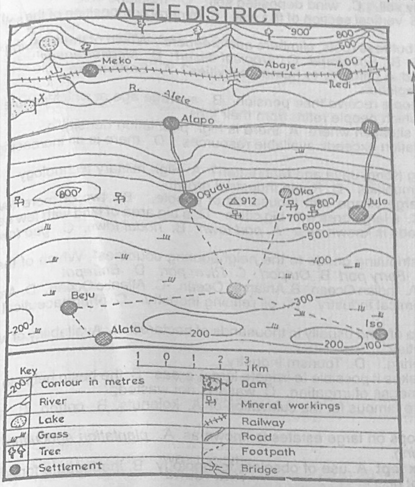
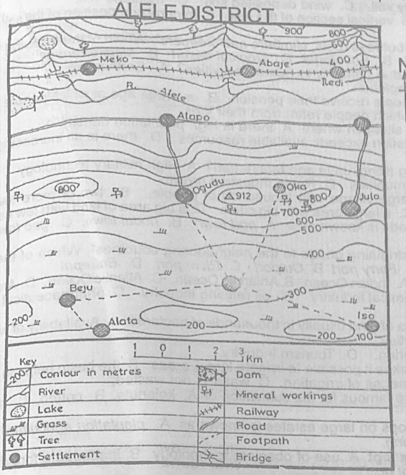
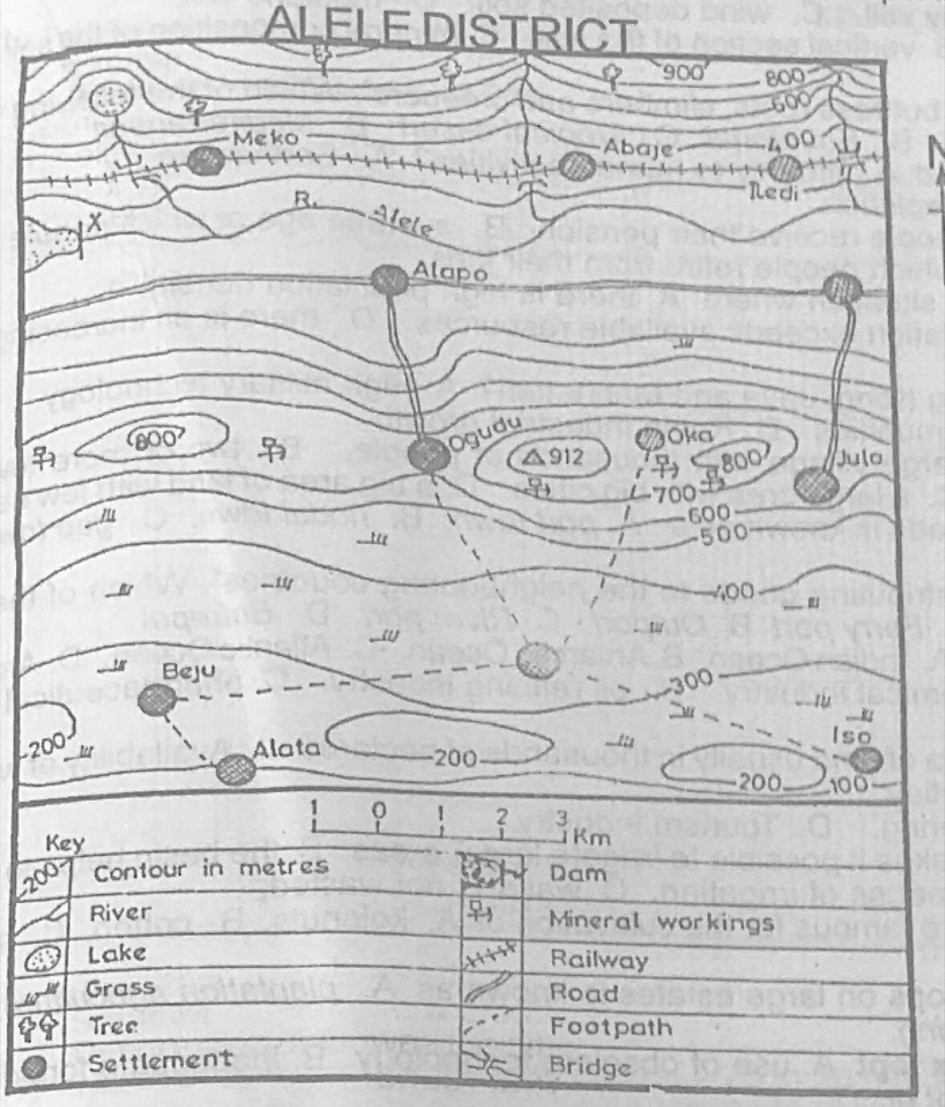
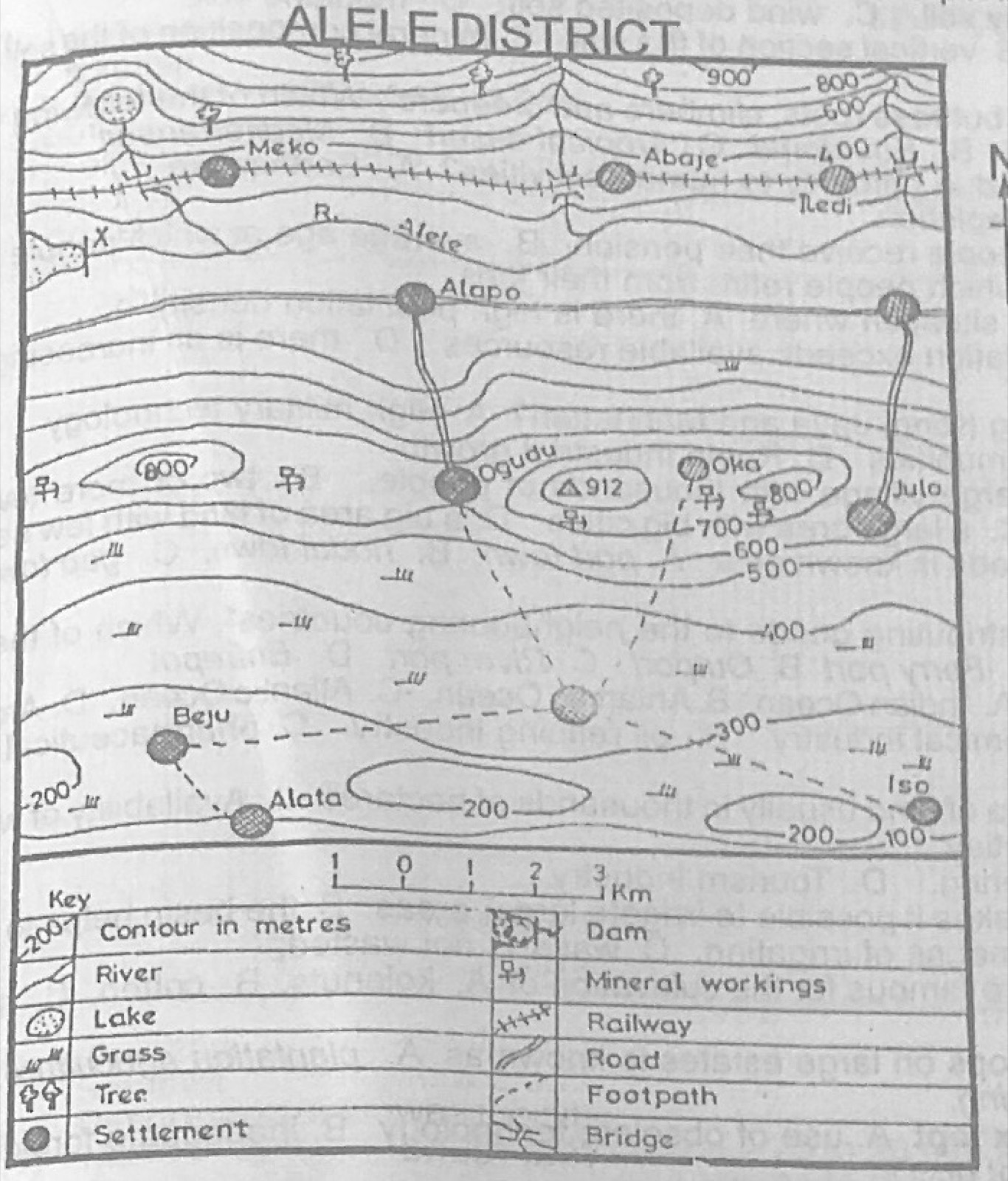
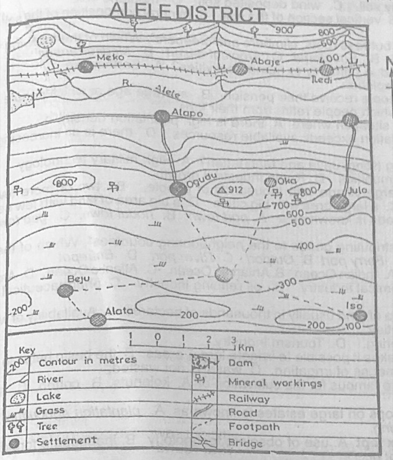
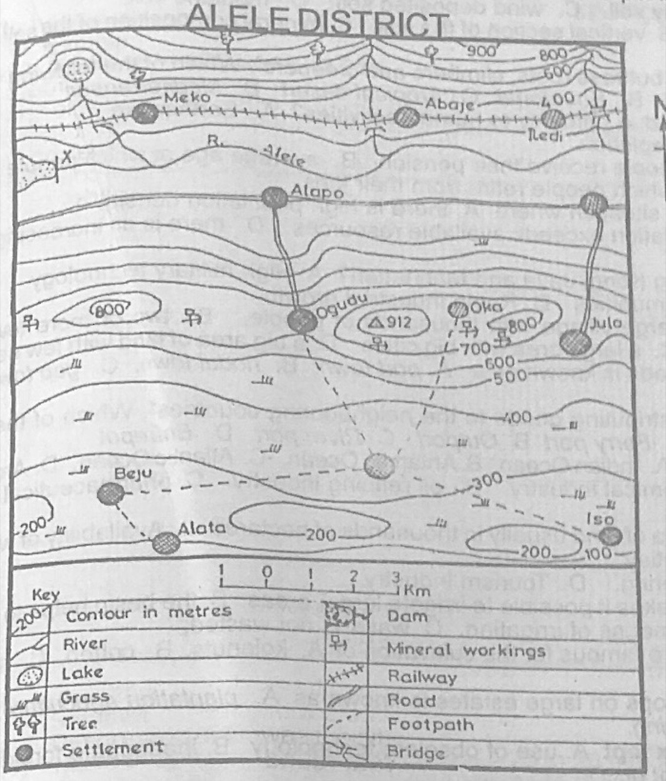
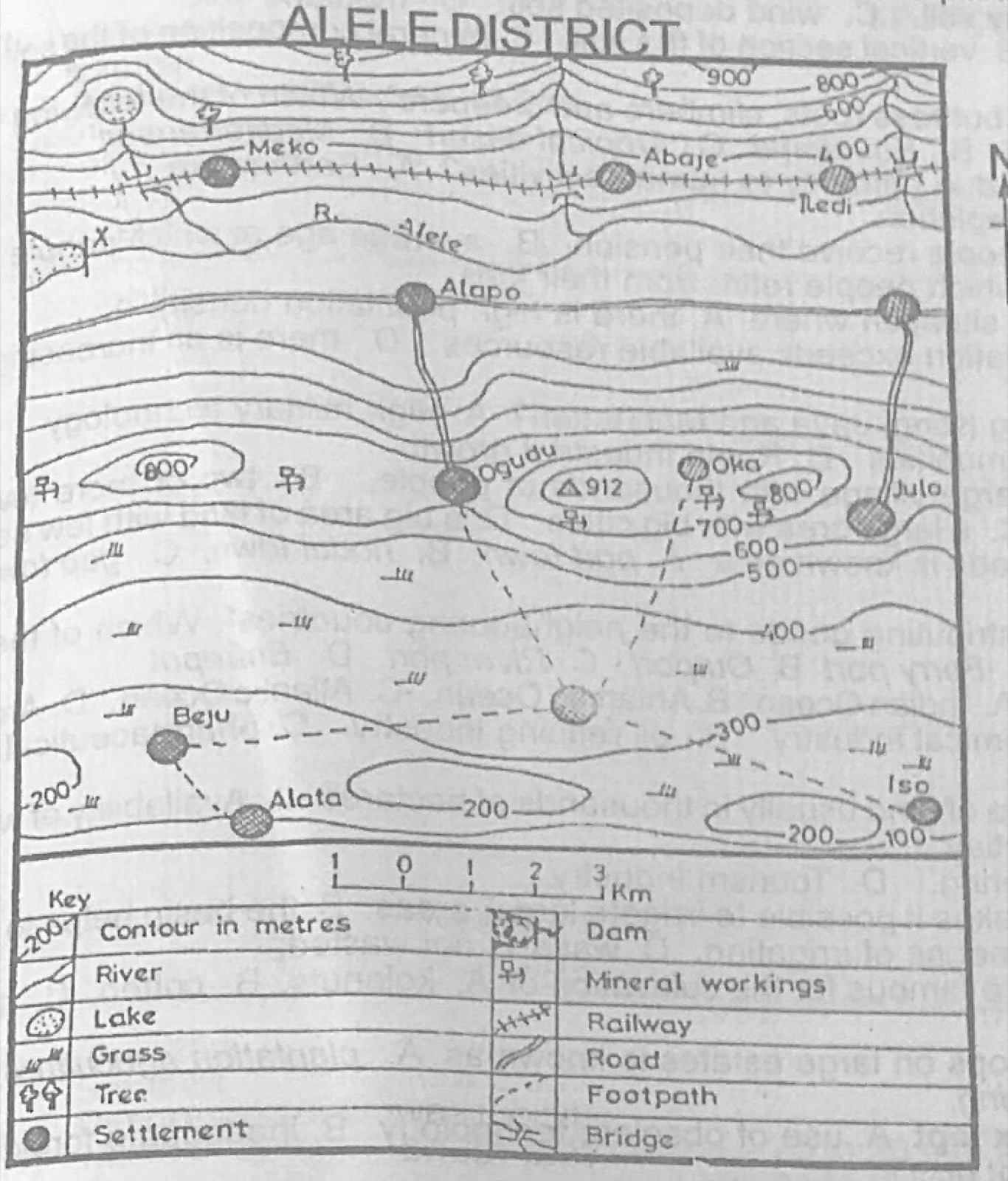
Study the map of ALELE DISTRICT to answer this question. Which of the following is most likely to be a major problem confronting the mining industry in the mapped area?
A.Availability of labour
B.Inadequate transportation facilities
C.Depth of the mines
D.Insufficient spare parts
Show the answer and explanation
Answer: B (Inadequate transportation facilities)
Explanation
The mineral workings are reached only by footpaths; there are few roads, so transport is the main problem.
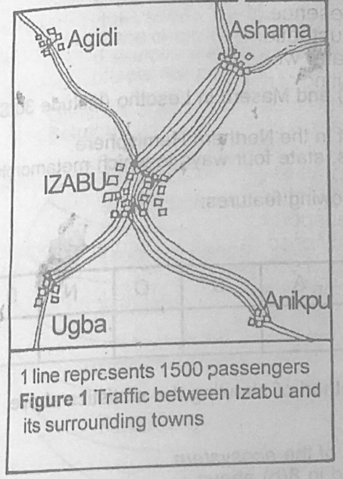
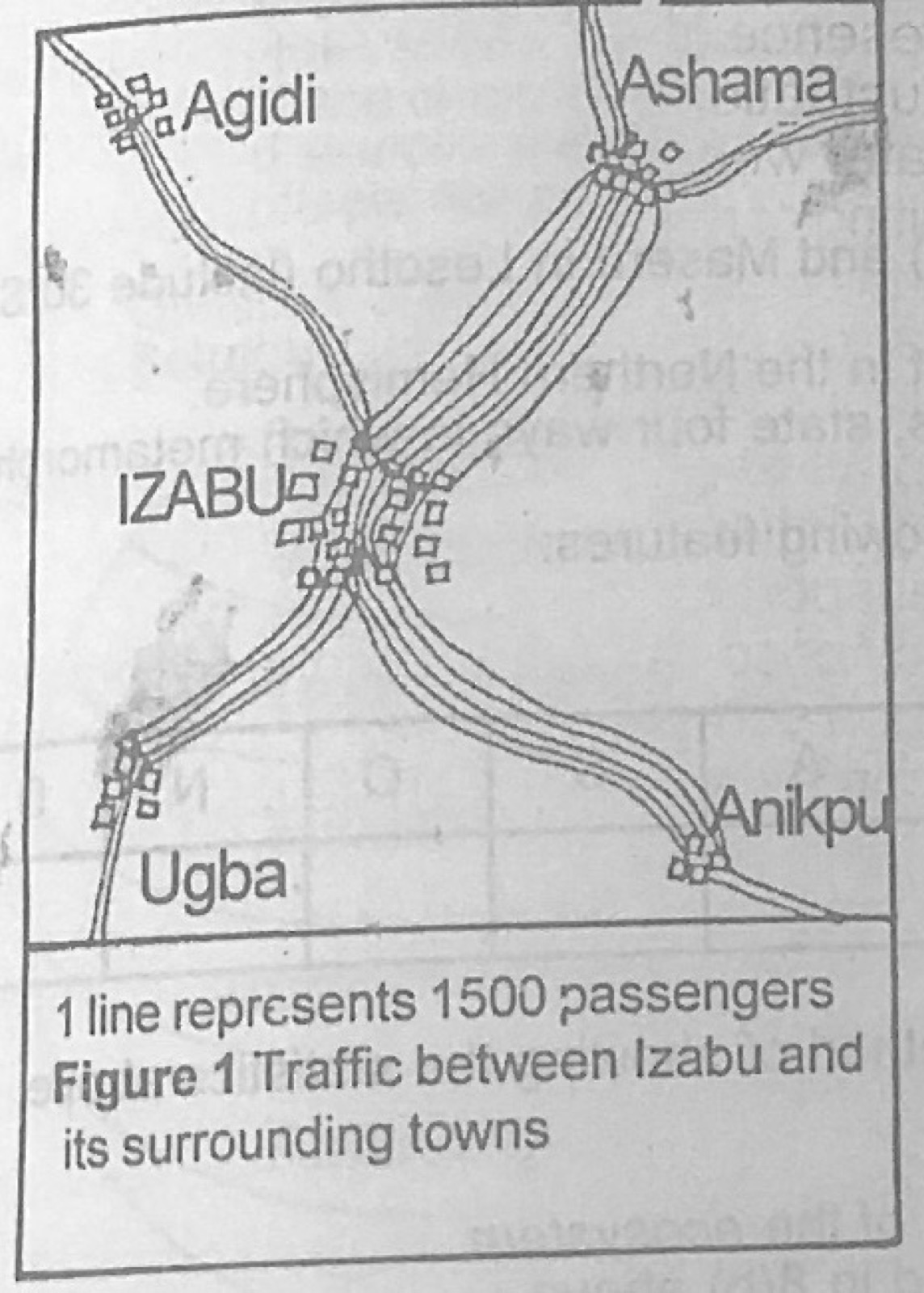
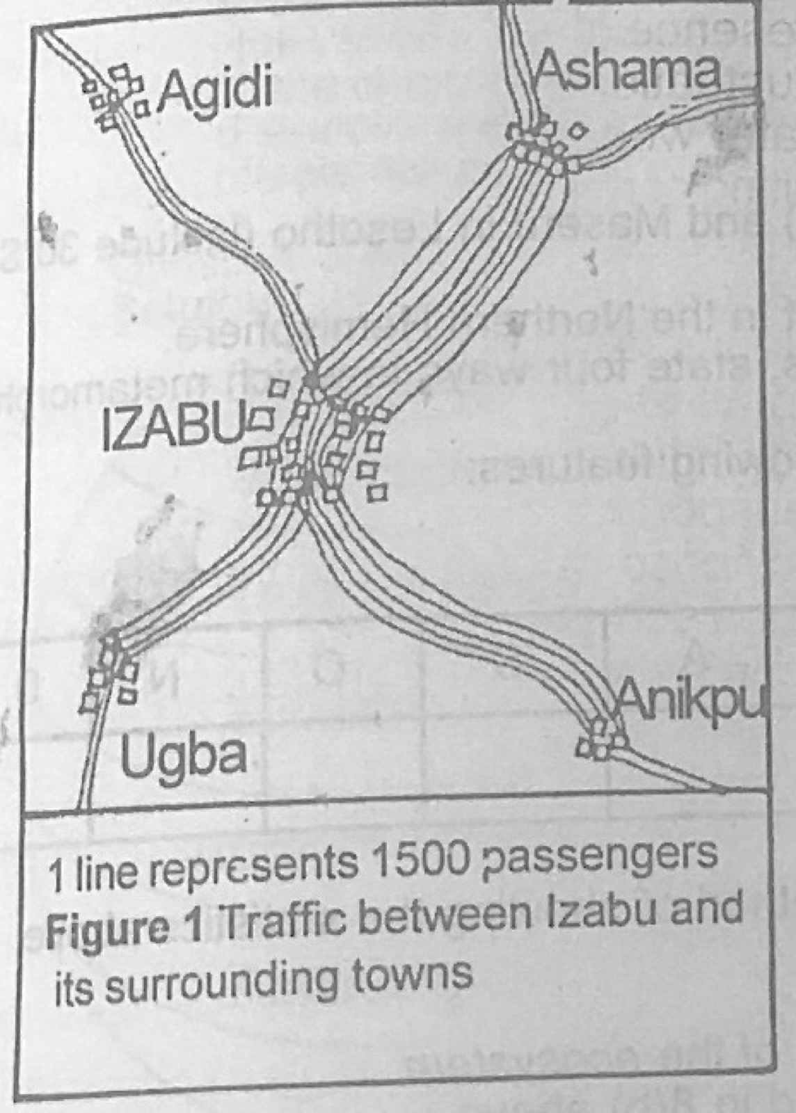
Use Figure 1 (Traffic between Izabu and its surrounding towns; 1 line represents 1500 passengers) to answer this question. What is the volume of passenger traffic between IZABU and Ashama?
A.12,000
B.10,000
C.8,000
D.6,000
Show the answer and explanation
Answer: A (12,000)
Explanation
There are 8 lines between Izabu and Ashama: 8 × 1500 = 12,000 passengers.
Use Figure 1 (Traffic between Izabu and its surrounding towns; 1 line represents 1500 passengers) to answer this question. By how much is the traffic between IZABU and Anikpu more than the traffic between IZABU and Ugba?
A.1,800
B.1,700
C.1,500
D.1,200
Show the answer and explanation
Answer: C (1,500)
Explanation
The Anikpu route has one more line than the Ugba route, and one line is 1500 passengers.
"The trees are evergreen, forming a canopy with buttress roots, climbers and creepers". Which of the following vegetation types does this statement refer to?
A.Savanna
B.Equatorial
C.Tropical desert
D.Mediterranean
Show the answer and explanation
Answer: B (Equatorial)
Explanation
Evergreen trees with a closed canopy, buttress roots and climbers describe the equatorial rainforest.
"It is a port that specializes in receiving and redistributing goods to the neighbouring countries". Which of the following ports is described in the preceding statement?
A.Ferry port
B.Outport
C.River port
D.Entrepot
Show the answer and explanation
Answer: D (Entrepot)
Explanation
An entrepot port receives goods and re-exports them to other countries.
Which activity requires the following? I. Large area of land usually in thousands of hectares II. Availability of water either in the form of rain or irrigation III. High capital outlay
A.Plantation Agriculture.
B.Mining.
C.Lumbering.
D.Tourism Industry.
Show the answer and explanation
Answer: A (Plantation Agriculture.)
Explanation
Plantations need large areas, plenty of water for the crops and heavy investment.
Write a geographical account of rail transport under the following headings: (a) economic importance, (b) problems; (c) solutions
Show the model answer
Model answer
(a) Carries bulky goods (minerals, cash crops, raw materials) cheaply over long distances; links producing areas to ports and markets; opens up new areas; moves people and labour; provides employment; promotes national unity and trade with neighbours; earns revenue. (b) Narrow gauge and single track; old engines and coaches, poor maintenance; slow speed and frequent breakdowns and derailments; high cost of building and spare parts; steep gradients, flooding; competition from road transport; poor management and timetables; inflexibility (cannot reach every door). (c) Convert to standard gauge and double tracks; modern locomotives and coaches; regular maintenance; better management and training of staff; government funding or private partnership; local production of spare parts; good drainage; link railways to other modes.
(a) Name: (i) two major export items from your country (ii) two major import items to your country (iii) two major trading partners of your country. (b) Highlight four benefits your country derives from trading with other countries (c) Identify three problems encountered by your country in international trade.
Show the model answer
Model answer
(a) Nigeria: (i) exports: crude oil, natural gas, cocoa, rubber, cashew, sesame; (ii) imports: machinery, vehicles, refined petroleum products, chemicals, wheat, rice, textiles; (iii) partners: China, USA, India, Netherlands, Spain, United Kingdom. (b) Earns foreign exchange; obtains goods the country cannot produce; encourages specialisation; widens markets for local products; government revenue (duties); jobs; transfer of technology; better international relations. (c) Dependence on one main export (oil) and falling or unstable prices; unfavourable balance of trade; tariffs and trade barriers abroad; poor quality and low processing of exports; poor ports and infrastructure; currency problems; smuggling and dumping of cheap goods.
Explanation
Use your own country's real products and partners.
(a) State four reasons for the concentration of manufacturing industries in the capital cities of Tropical African countries (b) Give three reasons for the predominance of consumer oriented industries in Tropical Africa (c) Describe three contributions of manufacturing industries to the economic development of Tropical African countries.
Show the model answer
Model answer
(a) Large market (big population, high incomes); good infrastructure (electricity, water, roads, ports, airports); availability of labour; banks and finance; government offices and incentives; many capitals are ports, convenient for importing raw materials and machinery; existing industries attract others. (b) Large local demand for everyday goods; need less capital and simple technology; raw materials available locally (agricultural products); quick returns on investment; import substitution policies; lack of skills and capital for heavy industry. (c) Provide employment; earn or save foreign exchange; add value to raw materials; government revenue from taxes; growth of towns and infrastructure; encourage agriculture by buying raw materials; technical skills; reduce dependence on imports; raise standards of living.
(a) Draw an outline map of Nigeria. On the map, show the annual distribution of rainfall (b) Highlight three effects of rainfall on the distribution of vegetation in Nigeria. (c) Describe four characteristics of the Guinea Savanna.
Show the model answer
Model answer
(a) Outline map of Nigeria with isohyets: over 2,000 mm along the coast and south-east (Niger Delta, Calabar); 1,500-2,000 mm in the south; 1,000-1,500 mm in the middle belt; 500-1,000 mm in the north; under 500 mm in the far north-east (Lake Chad area); with key and title. (b) High rainfall in the south gives mangrove/swamp and rainforest; moderate rainfall gives Guinea savanna; low rainfall in the north gives Sudan and Sahel savanna; trees get fewer, shorter and more drought-resistant northwards; grass becomes shorter. (c) Tall grasses (up to 3 m, e.g. elephant grass) with scattered trees; trees medium height, broad-leaved, deciduous, thick bark to resist fire; gallery forests along rivers; trees such as locust bean, shea butter, isoberlinia; grasses dry up and are burnt in the dry season; covers the middle belt.
(a) Draw an outline map of Nigeria. On the map, locate and name: (i) three major soil zones (ii) an important crop associated with each zone; (iii) an important town in any two of the zones (b) Describe the characteristic features of any two of the soil zones shown in 5(a)(i) above.
Show the model answer
Model answer
(a) Map with: northern zone of sandy soils (groundnuts, millet; Kano, Sokoto); middle belt zone of laterite / savanna soils (yams, guinea corn; Jos, Makurdi, Ilorin); southern zone of forest soils, ferrallitic/loamy (cocoa, oil palm, rubber; Ibadan, Benin, Enugu); also coastal swamp/alluvial soils (rice; Port Harcourt). (b) Sandy soils: loose, light, well drained, low in humus, formed under dry conditions, easily eroded by wind. Laterite soils: reddish, rich in iron and aluminium oxides, often form hard crust when exposed, low fertility, leached. Forest soils: dark, rich in humus, loamy, fertile on top but leached by heavy rain, deep. Alluvial/swamp soils: fine silt and clay, waterlogged, fertile.
(a) Draw a sketch map of Nigeria. On the map; mark and name: (i) one cattle rearing zone; (ii) one town in the zone; (iii) using arrows, show the movement of cattle from the producing area to two consuming markets. (b) Highlight three factors that favour cattle rearing in the area shown in 6(a)(i) above. (c) Outline three problems of cattle rearing in the area shown in 6(a)(i) above.
Show the model answer
Model answer
(a) Map showing the northern savanna cattle zone (or Jos/Mambilla Plateau); a town such as Kano, Sokoto, Maiduguri or Jos; arrows to consuming markets such as Lagos, Ibadan, Port Harcourt, Enugu. (b) Free of tsetse fly (dry climate); extensive grassland for grazing; open plains; traditional skill of the Fulani; long dry season limits diseases; large markets in the south; plateau areas cool and healthy. (c) Shortage of pasture and water in the dry season; cattle diseases (rinderpest, trypanosomiasis in wetter parts); poor breeds with low yield; nomadic system and long journeys that weaken animals; conflict with farmers; poor transport and storage; cattle rustling; lack of capital and veterinary services.
(a) Draw an outline map of West Africa. On it locate and name: (i) one area of dense population; (ii) one area of sparse population; (iii) an important town in each area; (iv) the River Niger (b) Explain four factors that have led to the high density of population in the area shown on your map (c) Highlight two problems of sparse population density
Show the model answer
Model answer
(a) Map with: dense areas, e.g. south-west Nigeria (Lagos, Ibadan), south-east Nigeria (Onitsha, Owerri), Kano close-settled zone, southern Ghana (Accra); sparse areas, e.g. the Sahel/Sahara in Niger and Mali (Agadez, Timbuktu), middle belt of Nigeria; River Niger drawn from the Guinea highlands through Mali, Niger and Nigeria to the delta. (b) Fertile soils for farming; adequate rainfall and good climate; mineral resources and industries; employment and commerce in towns and ports; historical factors (old kingdoms, slave raids pushing people to safe areas); good transport; social amenities; urbanisation and migration. (c) Resources not fully used; small markets; high cost of providing roads and amenities per head; shortage of labour; insecurity; slow development.
(a) Draw a sketch map of Africa. On the map, mark and name; (i) Rivers Nile and Limpopo; (ii) Lakes Victoria and Chad; (iii) Namib and Kalahari deserts (b) Outline four uses of rivers and lakes in Africa. (c) Highlight four factors that limit the use of rivers in Africa.
Show the model answer
Model answer
(a) Map with Nile (from Lake Victoria north to the Mediterranean), Limpopo (southern Africa to the Indian Ocean), Lake Victoria (East Africa on the Equator), Lake Chad (Chad/Nigeria/Niger/Cameroon), Namib desert (coast of Namibia), Kalahari desert (Botswana). (b) Transport; fishing; water for irrigation; hydro-electric power; domestic and industrial water supply; tourism and recreation; boundaries; source of sand and gravel. (c) Rapids, cataracts and waterfalls; seasonal flow (low water in the dry season); silting, sandbars and shallow mouths; water weeds such as water hyacinth; many flow through sparsely populated areas; disease vectors (blackfly, snails); lack of capital for dredging and ports.
Explanation
Place each feature in its right country or region.
(a) Draw a sketch map of Africa. On the map, mark and name: (i) the Rivers Niger and Nile; (ii) two areas of irrigation agriculture along each river. (b) Outline three contributions of irrigation agriculture to any of the area shown in 9(a)(ii) above. (c) Highlight three problems facing irrigation agriculture in the area chosen in 9(b) above.
Show the model answer
Model answer
(a) Map with River Niger (e.g. Office du Niger in Mali, Sokoto-Rima / Bakolori or Kano River Project in Nigeria) and River Nile (e.g. Gezira-Managil in Sudan, Nile valley and delta in Egypt). (b) Allows farming all year and in dry areas; higher yields of rice, cotton, wheat, sugarcane, vegetables; food security; cash crops for export earn foreign exchange; employment; raw materials for industries; settlement and better living standards. (c) Salinisation and waterlogging of soils; silting of canals; water-borne diseases (bilharzia, malaria); high cost of building and maintaining dams and canals; water weeds; evaporation losses; poor management; shortage of capital and skilled labour; disputes over water.
(a) Describe any three of the following survey instruments: (i) ranging poles; (ii) chain; (iii) cross staff; (iv) arrows. (b) Outline the processes involved in carrying out a Chain Survey.
Show the model answer
Model answer
(a) Ranging poles: straight wooden or metal poles about 2-3 m long, painted in red and white bands, pointed iron shoe; used to mark stations and line up survey lines. Chain: 20 m or 30 m of steel links joined by rings, brass handles at both ends, tallies every few metres; used to measure distances. Cross staff: a wooden head or metal box with slits at right angles, on a pole; used to set out offsets at right angles to the chain line. Arrows: thin steel pins about 40 cm long with a pointed end and a ring at the top, usually 10 in a set; used to mark chain lengths and count them. (b) Reconnaissance: walk over the area and choose stations; draw a rough sketch; fix stations with ranging poles so that they form triangles; measure each chain line (leader and follower, arrows counted); take offsets to features from the chain line with tape and cross staff; record everything in a field book; check lines; plot the survey to scale in the office.
Explanation
Describe at least three instruments: what each looks like and what it is used for.
(a) (i) With the aid of a diagram, identify the main lines of latitude. (ii) Calculate the distance between Addis Ababa in Ethiopia (latitude 10°N) and Maseru in Lesotho (latitude 30°S). (b) (i) Define revolution of the earth. (ii) Describe how revolution of the earth affects the length of day and night in the Northern Hemisphere.
Show the model answer
Model answer
(a)(i) Diagram of a globe showing the Equator (0°), Tropic of Cancer (23½°N), Tropic of Capricorn (23½°S), Arctic Circle (66½°N), Antarctic Circle (66½°S), North and South Poles (90°). (ii) Places are on opposite sides of the Equator, so add: 10° + 30° = 40°; 1° of latitude ≈ 111 km (69 miles), so 40 × 111 = about 4,440 km. (b)(i) Revolution is the movement of the earth round the sun in its orbit, taking 365¼ days (one year). (ii) Because the axis is tilted 23½° and keeps the same direction, the overhead sun moves between the tropics; about 21 June (summer solstice) the Northern Hemisphere leans towards the sun: days longer than nights, 24 hours of daylight north of the Arctic Circle; about 22 December (winter solstice) it leans away: nights longer, 24 hours of darkness north of the Arctic Circle; at the equinoxes (21 March, 23 September) the sun is overhead at the Equator and day equals night everywhere; the length of day changes more the further north a place is.
Explanation
Add the latitudes when places are in different hemispheres.
(a) Describe four characteristics of igneous rocks (b) Using specific examples, state four ways in which metamorphic rocks are useful to man.
Show the model answer
Model answer
(a) Formed from cooled and solidified magma or lava; crystalline (large crystals when cooled slowly underground, e.g. granite; small or glassy when cooled fast at the surface, e.g. basalt); not in layers (unstratified); contain no fossils; hard and resistant, mostly impermeable; may be acidic (light coloured, rich in silica) or basic (dark); intrusive or extrusive. (b) Marble for building, floor tiles and sculpture; slate for roofing and blackboards; graphite for pencils and lubricants; gneiss and quartzite for construction and road stone; precious stones such as diamonds and emeralds for jewellery; exports earn foreign exchange; tourist sites.
(a) With the aid of diagrams, describe the characteristics of any two of the following features: (i) meanders; (ii) flood plain; (iii) braided stream.
Show the model answer
Model answer
Meanders: loops or bends in the river's middle and lower course; outer (concave) bank is eroded and steep (river cliff); inner (convex) bank has deposition (slip-off slope, point bar); swing across a wide valley floor; may be cut off to form ox-bow lakes. Diagram of a winding channel with cross-section. Flood plain: flat, wide plain of alluvium on both sides of a river in its lower course; built up by deposits when the river floods; fertile soils; may have levees, ox-bow lakes and swamps; coarse material dropped near the river, fine further away. Diagram. Braided stream: river split into many small channels that divide and rejoin around sandbars or islands of deposits; occurs where the river carries a heavy load and loses speed (gentle gradient, seasonal flow); channels shift often. Diagram.
(a) What is soil profile? (b) Draw a well labelled diagram of soil profile. (c) Describe the characteristics of the three zones of soil profile.
Show the model answer
Model answer
(a) A vertical section of the soil from the surface down to the parent rock, showing its layers (horizons). (b) Diagram with title showing humus/leaf litter at top, A horizon (topsoil), B horizon (subsoil), C horizon (weathered parent material) and bedrock, all labelled. (c) A horizon (topsoil): dark, rich in humus and organisms, most roots, zone of eluviation (nutrients washed down). B horizon (subsoil): lighter colour, zone of illuviation where washed-down iron, aluminium and clay collect; may form hardpan; few roots. C horizon: partly weathered parent rock, little organic matter, source of the minerals for the layers above; lies on solid bedrock.
(a) Define ecosystem. (b) Identify, with examples, two main components of the ecosystem. (c) Describe the interdependence between the two main components identified in 8(b) above. (d) In what two ways can environmental balance be achieved?
Show the model answer
Model answer
(a) An ecosystem is a community of living things interacting with one another and with their non-living environment in a particular area. (b) Biotic (living) component: plants (producers), animals (consumers), micro-organisms (decomposers). Abiotic (non-living) component: soil, water, air, sunlight, temperature, rocks. (c) Plants use sunlight, water, carbon dioxide and soil nutrients to make food; animals eat plants and breathe oxygen given off by plants; decomposers break down dead matter back into soil nutrients; soil, water and air provide habitats; living things in turn change the soil (humus) and air (respiration). (d) Any two: afforestation/reforestation; conservation of wildlife and forest reserves; controlled use of resources; pollution control; recycling; proper waste disposal; keeping natural cycles (water, carbon, nitrogen) working.
Explanation
Name both components with examples before linking them.