67 questions. Try each one, then open the answer to check yourself and read the explanation.
Question 2
Map Scale, Distance and Direction
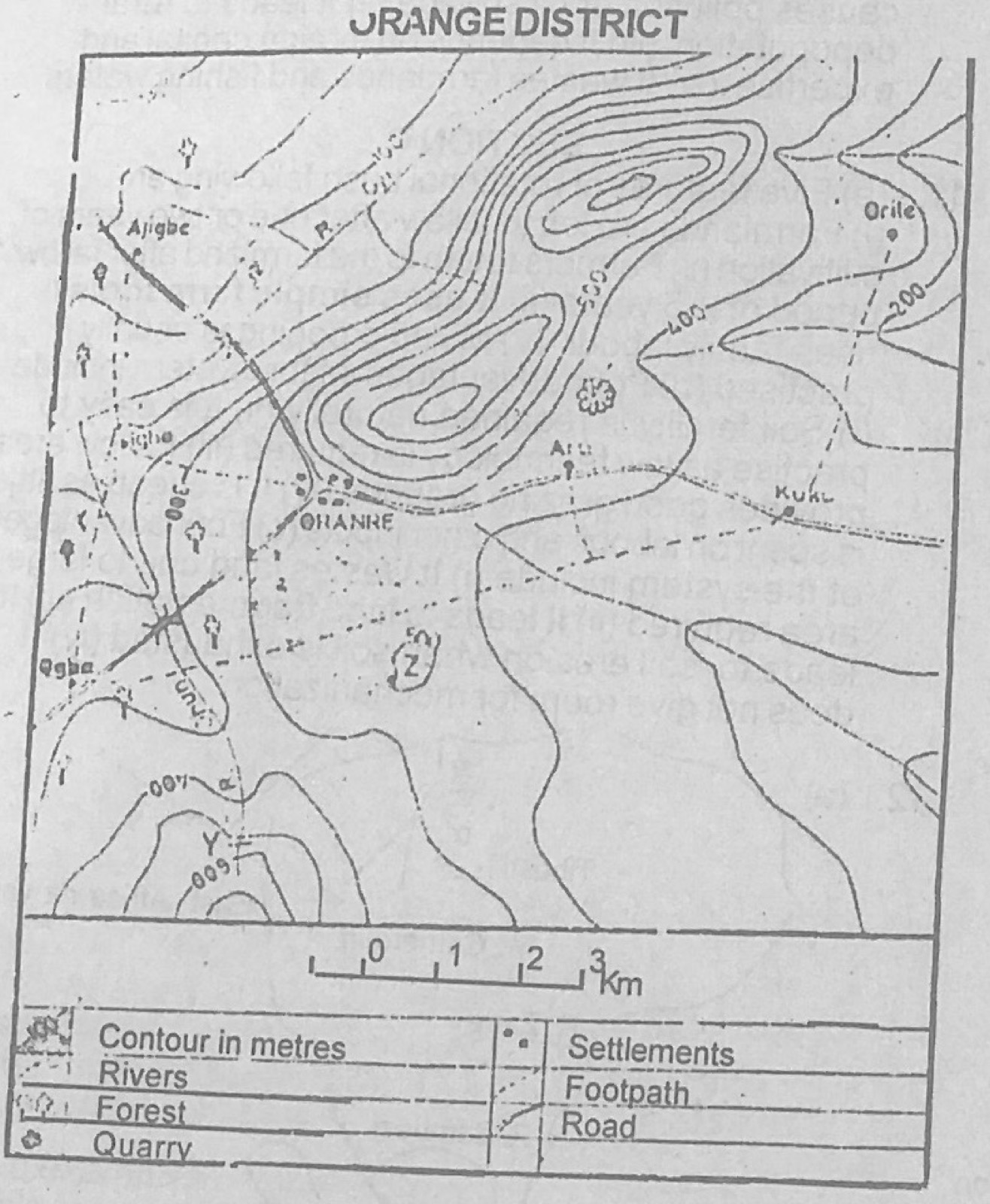
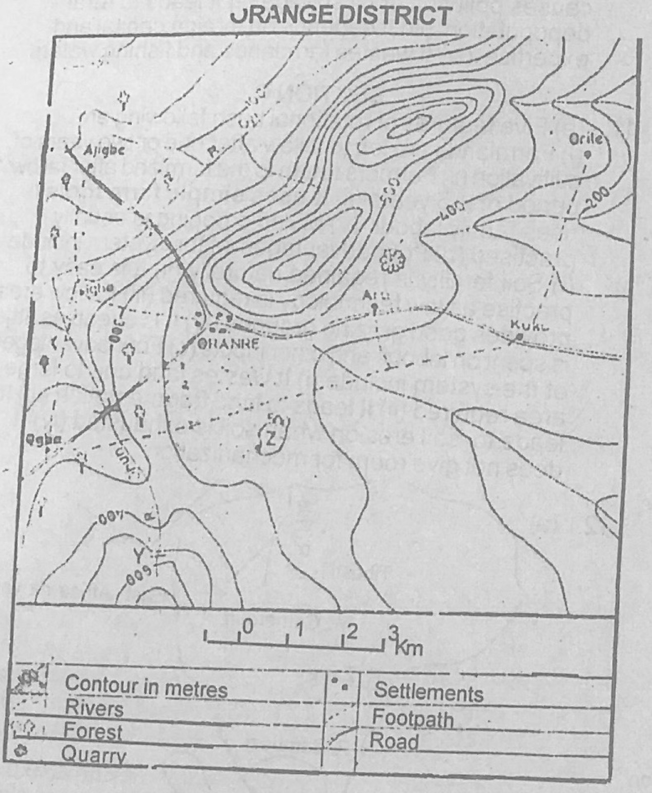
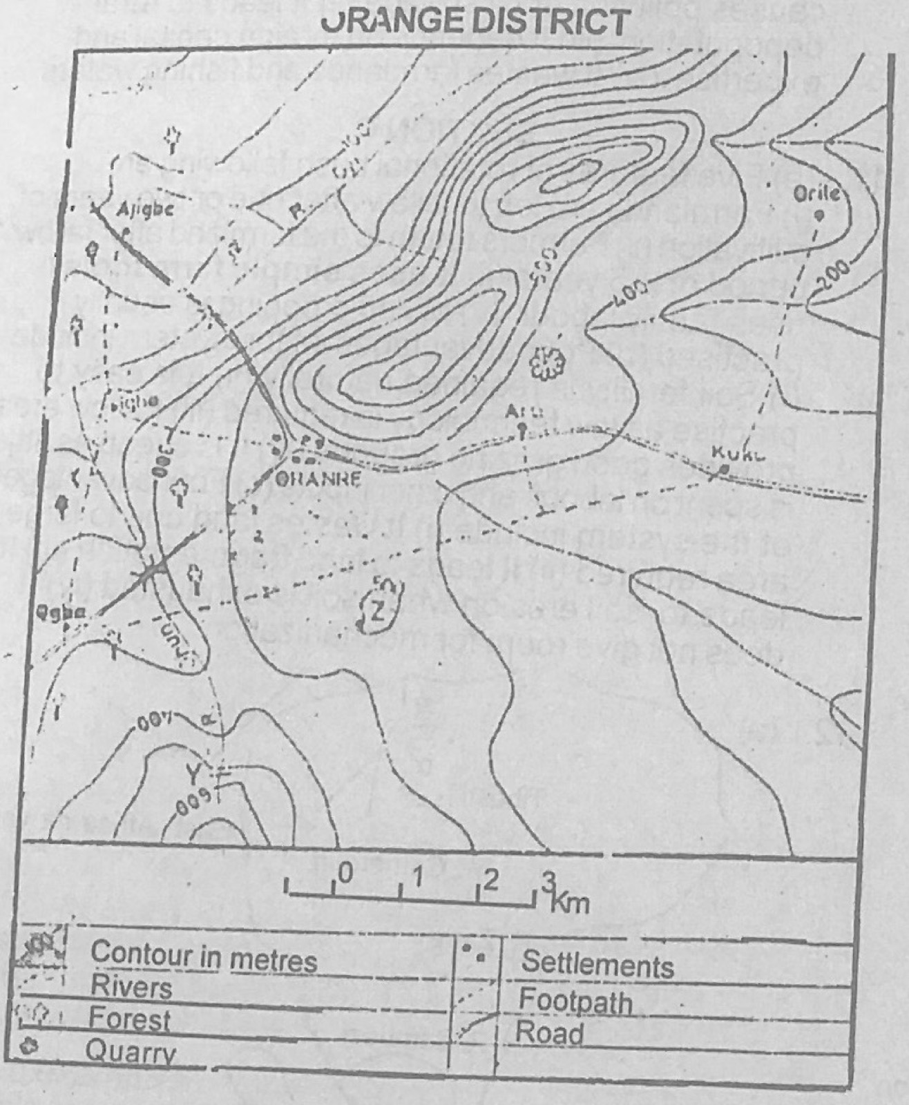
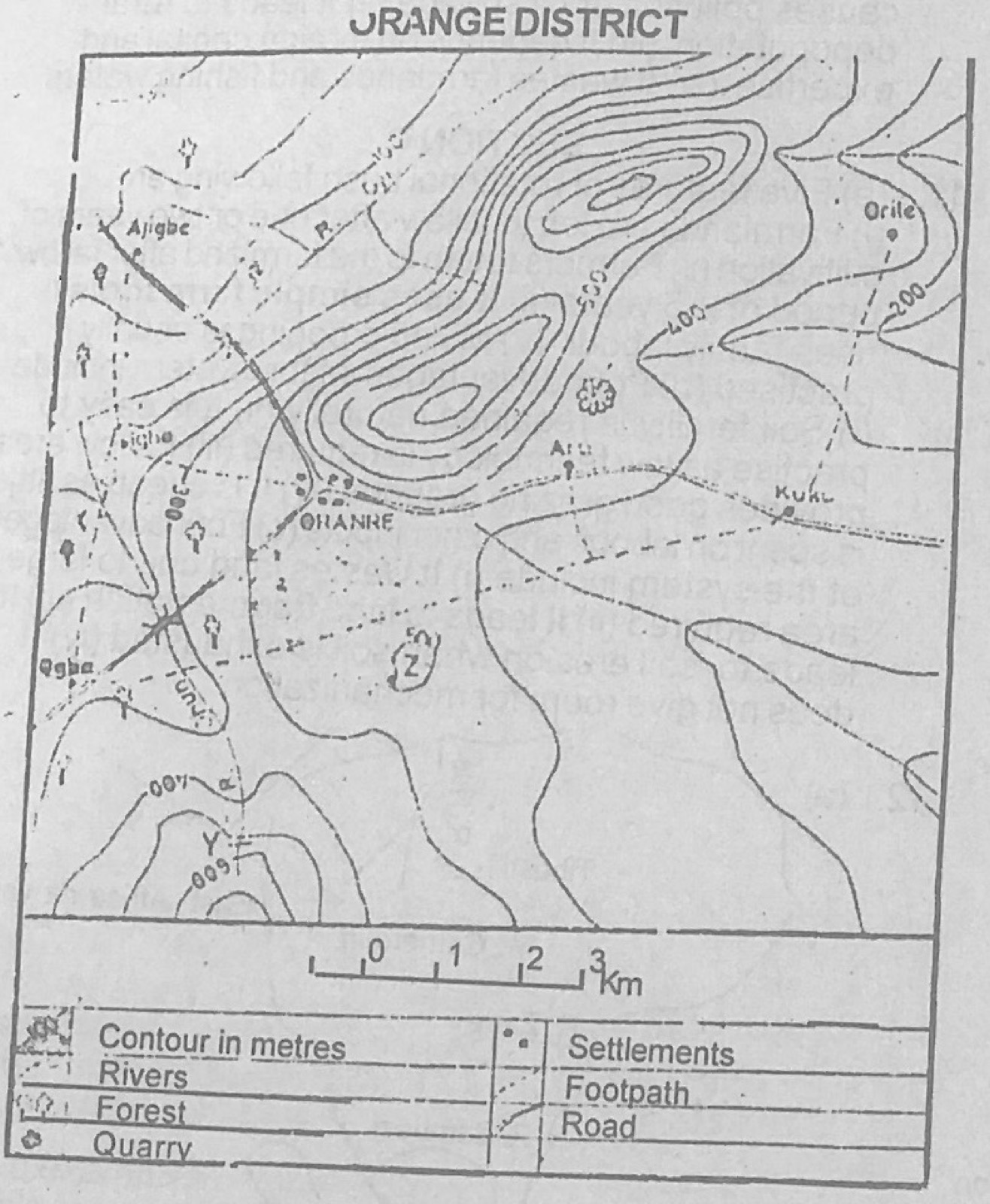
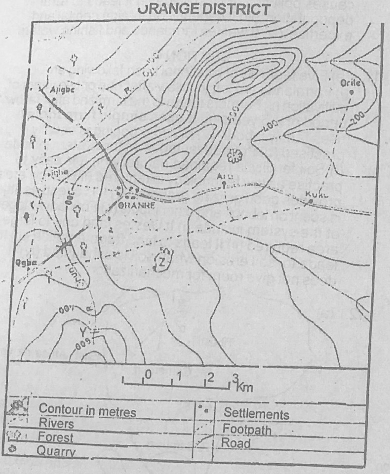
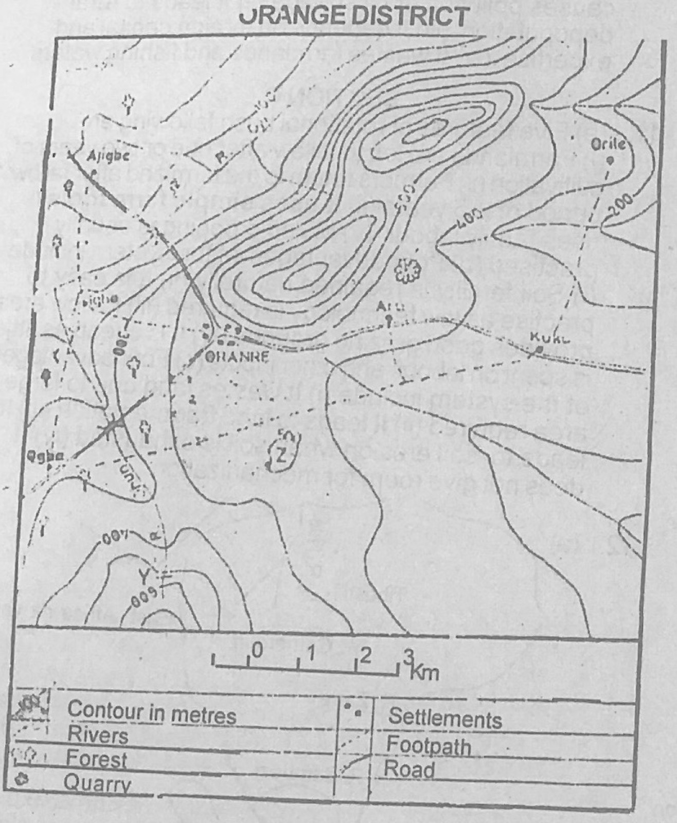
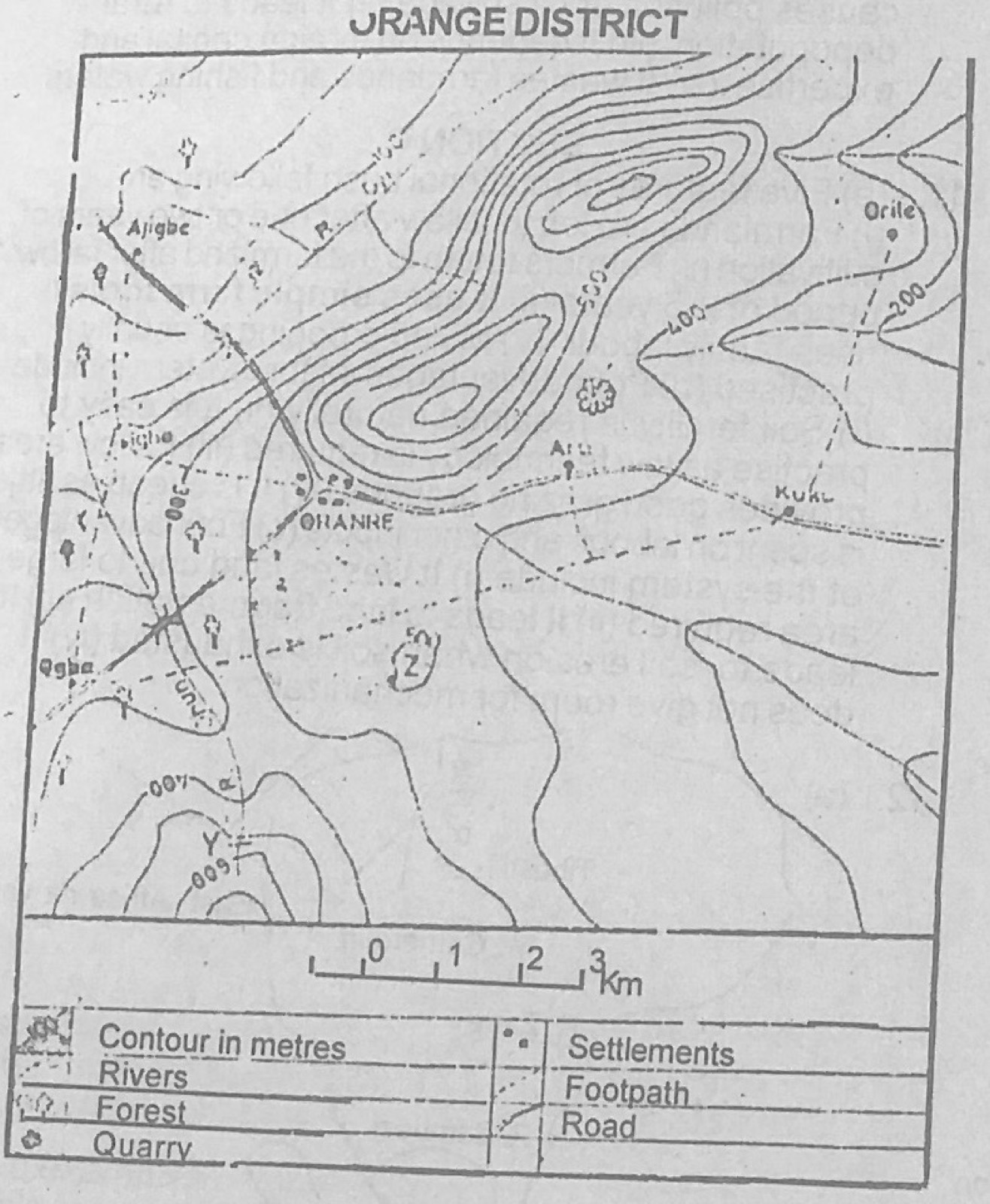
Use the map of ORANGE DISTRICT to answer this question. The actual distance by road from Ogba to Ajigba is about
A.8cm
B.11.4cm
C.5km
D.8km
E.11.4km
Show the answer and explanation
Answer: D (8km)
Explanation
Follow the road from Ogba north-east to Ohanre and then north-west to Ajigbe and measure it against the linear scale. The road is about 8 units of 1 km long, so the distance is about 8 km.
"The climate is characterised by an alternate hot, rainy season and cool, dry season. The vegetation consists mostly of tall grass and short trees which are mostly deciduous". The climate being described is the
A.savanna
B.cool temperate (British type)
C.warm temperate (China type)
D.tropical monsoon
E.desert
Show the answer and explanation
Answer: A (savanna)
Explanation
A hot wet season, a dry season, and tall grass with deciduous trees describe the savanna (tropical continental) climate.
The sparse population of the Middle Belt of West Africa could be traced to all the following factors except
A.inter-ethnic wars
B.Arab slave trade in the north
C.the swamps created by rivers Niger and Benue
D.European slave trade in the south
E.the presence of pests and diseases
Show the answer and explanation
Answer: C (the swamps created by rivers Niger and Benue)
Explanation
The Middle Belt was emptied by inter-ethnic wars, slave raids from both north and south, and tsetse and other diseases; river swamps are not a main cause.
(a) Explain any four factors that determine population distribution (b) Describe any two types of population movement (c) What four problems are associated with any one of the types of population movement described in (b)?
Show the model answer
Model answer
(a) Climate (moderate, well-watered areas attract people; deserts and very cold areas repel); relief (lowlands dense, rugged mountains sparse); soils (fertile soils attract farmers); minerals (mining towns); water supply; economic activities and jobs; transport; history, security and government policy. (b) Rural-urban migration (villagers move to towns for jobs and amenities); urban-rural (return migration); seasonal migration/transhumance; international migration; rural-rural. (c) e.g. rural-urban: overcrowding and slums in towns; unemployment and crime; pressure on amenities, traffic congestion; rural areas lose young labour so food production falls.
(a) In what four ways does a town differ from a village? (b) Describe with examples three functions which a town may perform for a village
Show the model answer
Model answer
(a) Town: larger population and area; mainly non-farming jobs (trade, industry, services); more amenities (hospitals, banks, schools); planned layout and taller buildings; heterogeneous population; focus of routes. Village: small population; mainly farming; few amenities; unplanned; homogeneous people. (b) Market for village produce and source of manufactured goods (e.g. Onitsha market); services such as hospitals, secondary schools, banks; jobs for villagers; administrative services (local government headquarters); transport links; news and new ideas.
Using specific examples, discuss rail transportation in African countries under the following headings (a) Reasons for construction (b) Problems (c) Solutions
Show the model answer
Model answer
(a) To carry export crops and minerals to ports (e.g. Zambian copper via TAZARA to Dar es Salaam; Lagos-Kano for groundnuts; Enugu coal to Port Harcourt); to open up the interior; for colonial administration and troop movement; to link major towns; to carry imports inland. (b) Narrow gauge and single tracks; old engines and coaches; slow and unreliable; lines run from ports inland with few links between countries; different gauges; poor maintenance and management; competition from roads; high cost. (c) Standard gauge and double tracks; new rolling stock; better funding and management (or privatisation); linking national networks; improved maintenance and training.
(a) Name two examples of local craft and two of manufacturing industries in Tropical Africa (b) Outline any five factors which affect the location of manufacturing industries in Tropical Africa (c) What three problems face manufacturing industry in the sub-region?
Show the model answer
Model answer
(a) Crafts: pottery, weaving, leather work, wood carving, blacksmithing. Manufacturing: textiles, cement, food processing, brewing, oil refining, vehicle assembly. (b) Raw materials; power; market; transport; labour; capital; water; government policy; port location. (c) Inadequate capital; erratic power supply; poor transport; shortage of skilled labour; small home market and low purchasing power; competition from imports; dependence on imported raw materials and spare parts; political instability.
Explanation
Separate crafts (hand-made at home) from factory industry.
(a)(i) Name any one country in Europe that trades with Nigeria (ii) Identify any two commodities exported by each trading partner (b) State four benefits which both countries derive from their trade relations (c) Highlight any four problems facing the trade between the two countries in (a)(i) above
Show the model answer
Model answer
(a)(i) e.g. United Kingdom (or Germany, France, Netherlands). (ii) Nigeria exports crude oil, cocoa, rubber; UK exports machinery, vehicles, chemicals, textiles/drugs. (b) Each obtains goods it cannot produce; foreign exchange; markets for industries; employment; better relations and exchange of technology; higher standard of living. (c) Nigeria exports mainly raw materials with low prices; unfavourable balance of trade for Nigeria; fall in value of the naira; tariffs and trade restrictions; shortage of foreign exchange; poor quality of some exports; political problems.
(a) On an outline map of Nigeria show and name: (i) one area with an annual rainfall below 100cm (ii) one area with an annual rainfall below 300cm (iii) two important towns in each area (b) Describe four other climatic features of the area shown in (a)(ii) above (c) Name the vegetation type associated with the climate described in (b) above and outline its characteristics
Show the model answer
Model answer
(a) Area below 100 cm: far north/north-east (Sokoto, Kano, Maiduguri, Nguru). Area of very high rainfall (over 300 cm): south-east coast/Niger Delta (Port Harcourt, Warri, Calabar, Bonny). (b) High temperatures all year (about 26-27°C); small annual range (about 2-3°C); double maxima of rainfall; no month without rain / short dry season; high humidity; heavy convectional rainfall. (c) Rain forest/mangrove swamp forest: dense evergreen trees; tall trees in layers with continuous canopy; many species mixed together; lianas and epiphytes; mangroves with stilt roots in the coastal swamps.
Explanation
The question prints 'below 300cm' for (ii); the map answer should show the very wet south-east coast.
(a) Draw a sketch map of Nigeria and on it locate and name: (i) the Niger-Benue trough (ii) the rivers Niger and Benue (iii) one confluence town (iv) Bacita and Numan (b) Describe the commercial production of sugarcane in the Niger-Benue Trough under the following headings: (i) method of cultivation (ii) method of harvesting (iii) economic importance
Show the model answer
Model answer
(a) Map showing the trough along the Niger (from Jebba) and the Benue valley, the two rivers meeting at Lokoja (confluence town), Bacita near Jebba on the Niger and Numan on the Benue. (b)(i) Large estates (Bacita, Numan); land cleared and ploughed by machine; cane cuttings planted in rows; irrigation from the rivers in the dry season; fertilisers and weed control. (ii) Harvested after about 12-18 months; fields sometimes burnt to remove leaves; canes cut close to the ground by machete or machine; carried quickly by truck or tractor to the factory before the sugar content falls. (iii) Raw material for sugar factories; saves foreign exchange on sugar imports; employment; income for farmers and government; by-products (molasses, bagasse for fuel); growth of settlements and infrastructure.
Explanation
Locate Bacita on the Niger and Numan on the Benue.
(a) On an outline map of Nigeria, locate and name: (i) the rain-forest belt (ii) one area of montane vegetation (iii) two towns important for lumbering within the forest belt. (b) Describe any four factors which have favoured the production of timber in Nigeria (c) Outline any four problems facing the lumbering industry in Nigeria
Show the model answer
Model answer
(a) Rain forest belt across the south; montane vegetation on the Jos Plateau, Mambilla or Obudu Plateau; lumber towns such as Sapele, Benin City, Ijebu-Ode, Ondo, Calabar. (b) Heavy rainfall and high temperatures supporting big trees; valuable hardwood species (iroko, mahogany, obeche, abura); demand at home and abroad; rivers for floating logs; sawmills and ports (Sapele, Lagos); labour. (c) Trees of one species scattered, making extraction costly; poor roads especially in the rainy season; depletion of forests and slow regeneration; heavy logs difficult to move; inadequate equipment and capital; illegal felling.
Describe the distinguishing characteristics of either the Western Highlands or the Eastern Highlands under the following heading: (a) Relief and drainage (b) Agriculture (c) Problems of development
Show the model answer
Model answer
Western Highlands: (a) Old basement rocks, 300-600 m, dissected plateau with inselbergs (Idanre Hills, Olumirin); highest parts in Ekiti; rivers flow south to the lagoons (Ogun, Osun, Oshun, Owena) and north to the Niger (Moshi, Oyi). (b) Food crops (yam, cassava, maize, rice); tree crops (cocoa, kola, coffee, oil palm, citrus); some livestock (goats, sheep, poultry, Muturu cattle). (c) Soil erosion; seasonal shortage of water; poor rural roads; pests and diseases; ageing cocoa trees; migration of youths to towns; flooding in valleys. (Or Eastern Highlands: Obudu, Mambilla, Adamawa; source of Cross, Donga, Katsina Ala; cattle, tea; problems of remoteness and rugged relief.)
On a sketch map of Nigeria, locate and name: (i) the rivers Imo and Kaduna (ii) two HEP stations (iii) two thermal stations (iv) two oil refineries (b) In what three ways has the oil industry contributed to the economic development of Nigeria? (c) State four problems arising from the exploitation of crude oil in Nigeria
Show the model answer
Model answer
(a) River Imo in the south-east flowing to the Atlantic; River Kaduna flowing south-west to the Niger; HEP: Kainji, Jebba, Shiroro; thermal: Egbin (Ijora), Afam, Sapele, Ughelli, Oji River; refineries: Port Harcourt (Alesa-Eleme), Warri, Kaduna. (b) Main source of foreign exchange and government revenue; employment; fuel and petrochemical raw materials; infrastructure development; growth of towns (Port Harcourt, Warri). (c) Oil spills polluting land and water; gas flaring; destruction of farms and fishing grounds; neglect of agriculture; conflicts and unrest in producing communities; rural-urban migration; dependence on foreign companies.
(a) Highlight any five features of rotational bush fallowing as practised in West Africa (b) State four advantages of this system of agriculture (c) Outline any four disadvantages of the system
Show the model answer
Model answer
(a) Land cultivated for 2-3 years then left fallow to regain fertility; farmer moves to another plot but stays in the same village; land cleared by slash and burn; simple tools (hoe, cutlass); family labour; mixed cropping of food crops; small plots, mainly subsistence. (b) Soil fertility restored naturally without fertiliser; cheap, needs little capital; easy with simple tools; fallow land provides grazing and fuelwood; mixed crops reduce risk. (c) Needs a lot of land; low yields; cannot support a growing population (fallow periods shorten); bush burning destroys humus and causes erosion; land fragmentation; does not allow mechanisation.
Explanation
Contrast with shifting cultivation: the village stays put.
(a) Draw an outline map of Africa and on it, locate the (i) rivers Zambesi, Nile and Zaire (ii) mounts Cameroun, Drakensberg and Tibesti (iii) East African Rift Valley (b) Using specific examples explain three effects of mountains on the climate of Africa (c) Describe any four ways in which the highlands of Africa are of economic importance
Show the model answer
Model answer
(a) Map with the Nile flowing north to the Mediterranean, Zaire (Congo) curving through central Africa to the Atlantic, Zambezi flowing east to the Indian Ocean; Mt Cameroon near the Gulf of Guinea, Drakensberg in south-east South Africa, Tibesti in northern Chad; the rift valley from Ethiopia through Kenya/Tanzania (with the western arm). (b) Temperatures fall with height (cool East African highlands, Jos Plateau); windward slopes get heavy relief rain (Mt Cameroon, east side of Drakensberg); leeward sides are dry rain-shadow areas (west of the Drakensberg, Karoo). (c) Cool climate for crops like tea and coffee and for settlement; minerals; sources of rivers and HEP; tourism; pasture for livestock; forests.
(a) On a sketch map of Africa, locate and name: (i) one area with an equatorial climate (ii) one area with a desert climate (iii) one major town in each area (b) Describe three major characteristics of any one of the climatic types shown on your map (c) Identify any three ways in which natural vegetation has adapted to the climate in the area selected in (b)
Show the model answer
Model answer
(a) Equatorial: Zaire (Congo) Basin (Kisangani) or Gabon (Libreville); desert: Sahara (e.g. Agadez, In Salah, Rabat is on the edge) or Kalahari/Namib. (b) Equatorial: high temperatures all year (about 27°C) with small annual range (2-3°C); heavy rain all year (over 1500 mm) with double maxima; convectional thunderstorms in the afternoon; high humidity. (Desert: very low rainfall; very hot days and cold nights; clear skies.) (c) Equatorial forest: broad leaves with drip tips to shed water; evergreen because there is no dry season; tall trees in layers competing for light; buttress roots; lianas and epiphytes. (Desert: thorny/small leaves, long roots, water storage.)
(a) Draw a sketch map of Africa and on it show the following vegetation belts: (i) Tropical rain-forest (ii) Tropical grassland (iii) Temperate grassland (b) Describe any four characteristics of the Tropical rainforest of Africa (c) In what four ways is the Tropical rain-forest of economic importance to Africa?
Show the model answer
Model answer
(a) Rain forest in the Zaire Basin and along the Guinea coast; tropical grassland (savanna) in belts north, east and south of the forest; temperate grassland (veld) on the high plateau of South Africa. (b) Tall evergreen trees (up to 45-60 m); three layers with a continuous canopy; many species mixed (not pure stands); hardwoods; buttress roots; lianas and epiphytes; little undergrowth where the canopy is thick. (c) Timber and plywood (export and local use); food such as fruits, nuts, game; raw materials (rubber, oil palm, raffia, medicines); fuelwood; foreign exchange; tourism and wildlife; protects soils and water catchments.
(a) Name four irrigation schemes within the Nile Basin(two in Egypt and two in Sudan) (b) Select any one of the schemes and describe the factors which have favoured its development (c) Outline the countributions of the scheme in (b) above to the economic development of the area (c) Highlight any three problems associated with irrigation schemes in the Nile Valley
Show the model answer
Model answer
(a) Egypt: Aswan High Dam scheme, the Nile Delta perennial canals, Kom Ombo, Wadi Halfa/New Valley. Sudan: Gezira, Managil extension, Khashm el Girba, Kenana. (b) e.g. Gezira: flat clay plain between the Blue and White Niles; gentle slope allowing gravity flow from the Sennar Dam; impervious clay soils holding water; low unreliable rainfall making irrigation necessary; hot climate suited to cotton; government and capital support; cheap labour; rail links to Port Sudan. (c) Cotton for export and foreign exchange; food crops (wheat, sorghum, groundnuts); employment and settlement; government revenue; growth of industries (ginneries) and towns. (d) Silting of reservoirs and canals; salinisation of soils; water-borne diseases such as bilharzia; high cost of maintenance; resettlement of displaced people; disputes over Nile water.
Explanation
The question prints (c) twice; the last part is about problems.
Using relevant sketches, distinguish between (a) solstice and equinox B. the earth's rotation and revolution C. parallels of latitude and meridians of longitude
Show the model answer
Model answer
Sketch of the earth's positions round the sun on 21 March, 21 June, 23 September and 22 December. (a) Equinox: sun overhead at the equator; equal day and night everywhere; 21 March and 23 September. Solstice: sun overhead at a tropic (Cancer 21 June, Capricorn 22 December); longest/shortest days; midnight sun or polar night inside the polar circles. (b) Rotation: earth spins on its axis west to east once in 24 hours; causes day and night, time differences and deflection of winds. Revolution: earth moves round the sun in 365¼ days; with the tilted axis it causes seasons, changing lengths of day and night and the leap year. (c) Parallels: run east-west, parallel, measure 0-90° N or S, get shorter towards the poles, only the equator is a great circle. Meridians: run north-south from pole to pole, meet at the poles, measure 0-180° E or W of Greenwich, all equal in length, used to find time.
(a) Discuss, using specific examples, any four factors that determine the pattern of movement of ocean currents in the North Pacific Ocean (b) Select any one cold current in the North Pacific Ocean and outline its effects on the climate of the adjacent coastland
Show the model answer
Model answer
(a) Planetary winds: NE trades drive the North Equatorial current westwards; westerlies drive the North Pacific Drift eastwards. Earth's rotation (Coriolis force) deflects currents to the right, giving a clockwise gyre (Kuroshio north, California current south). Shape of coastlines: Asia turns the current north as the Kuroshio; North America turns it south as the California current. Temperature and density differences: warm water moves poleward, cold water (Oyashio/Kamchatka) moves towards the equator. Salinity differences. (b) e.g. California current: lowers coastal temperatures; winds over it are cooled so little rain falls (dry coast, Mexican/Californian desert); frequent fog along the coast (San Francisco); reduces the annual range. (Or Oyashio/Kamchatka current: cold, foggy coasts of north-east Asia and Japan, frozen harbours.)
With the aid of suitable diagrams describe the appearance and process of formation of any two of the following landforms (a) Rock pedestal (b) Depression (c) Barchan (d) Inselberg
Show the model answer
Model answer
Rock pedestal: mushroom-shaped rock, wide top on a narrow base; formed in deserts by wind-borne sand abrading the lower part most (sand rarely lifted above 1-2 m), helped by softer lower layers. Depression (desert): hollow scooped out by wind deflation, e.g. Qattara depression; wind removes loose sand down to the water table, where oases may form. Barchan: crescent-shaped sand dune with horns pointing downwind, gentle windward slope and steep leeward slip face; formed where wind blows from one direction over a limited sand supply around an obstacle; moves forward slowly. Inselberg: isolated steep-sided rocky hill rising abruptly from a plain, often granite (e.g. Idanre, Zuma Rock); formed when the surrounding land is worn down by weathering and erosion while the resistant rock remains. Each with a labelled diagram.
Explanation
Choose two and include a labelled diagram for each.
(a) Outline any four factors that can influence climate of a place (b) In what three ways does climate affect man?
Show the model answer
Model answer
(a) Latitude; altitude; distance from the sea (continentality); ocean currents; prevailing winds; relief and aspect; pressure belts; vegetation cover. (b) Type of clothing; type of houses and building materials; crops grown and farming activities; health and diseases (malaria in humid areas); transport (fog, floods, snow); human activity and energy; settlement and population distribution; tourism.
Describe desert encroachment under the following headings (a) causes (b) areas liable (c) effect (d) methods of prevention
Show the model answer
Model answer
(a) Long droughts and low rainfall; overgrazing; deforestation and fuelwood cutting; bush burning; over-cultivation; climate change. (b) Sahel belt bordering the Sahara (northern Nigeria: Sokoto, Katsina, Kano, Borno, Yobe; Niger, Chad, Mali); edges of the Kalahari. (c) Loss of farmland and pasture; loss of vegetation and wildlife; drying of rivers and lakes; famine; migration of people; sandstorms and buried settlements. (d) Afforestation and shelter belts; controlled grazing; laws against bush burning and tree felling; irrigation and water conservation; alternative fuels; public education.
(a) Using specific examples, describe any three causes of air pollution (b) Outline three major effects of air pollution (c) Suggest any three ways of controlling air pollution
Show the model answer
Model answer
(a) Exhaust fumes from vehicles (Lagos traffic); smoke and fumes from factories and power stations; gas flaring in the Niger Delta; bush burning; mining and quarrying dust; burning refuse; harmattan dust. (b) Respiratory diseases and other health problems; acid rain damaging buildings, crops and forests; depletion of the ozone layer; global warming; poor visibility leading to accidents; smog. (c) Laws and monitoring on emissions; filters and cleaner technology in factories; well-maintained vehicles and unleaded fuel; stopping gas flaring; tree planting; public education on waste burning.