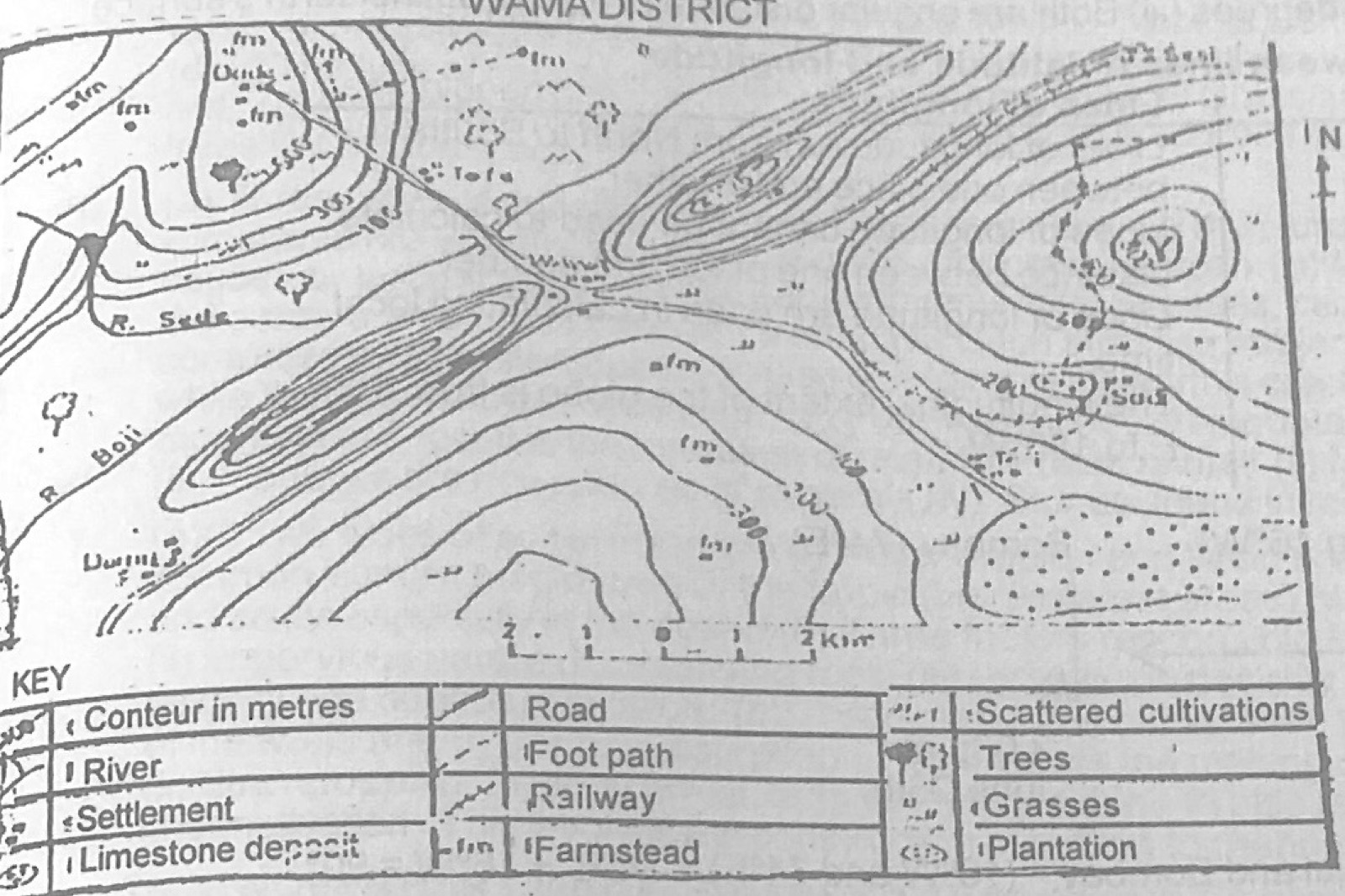
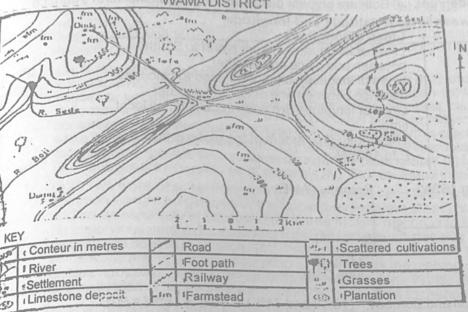
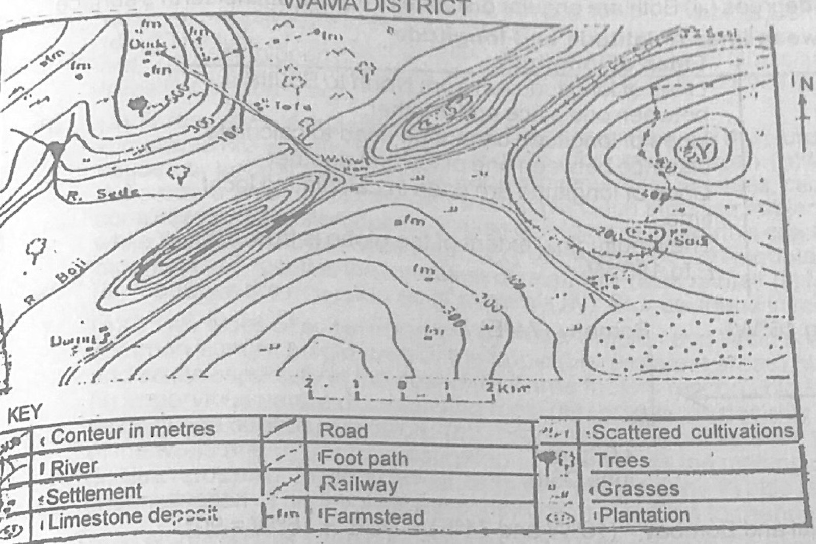
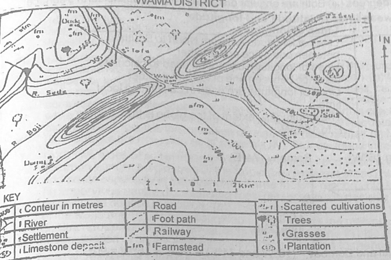
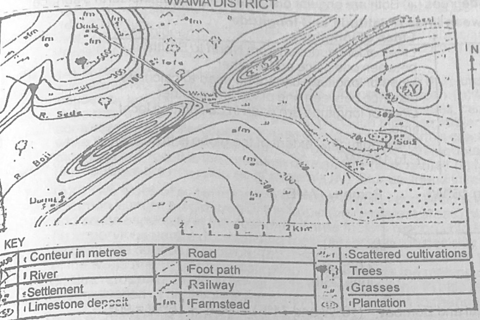
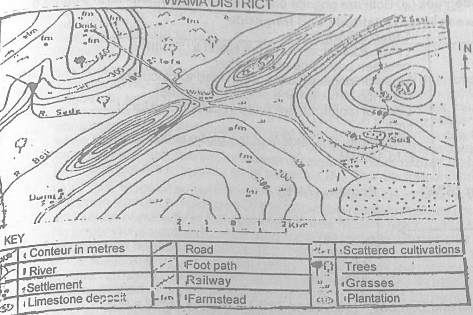
Use the map of WAWA DISTRICT to answer the question. The most probable reason for the construction of the road from Wawa through Tafi to the plantation is
A.to carry the mineral products from Sadi inland
B.to provide a means of transporting manufactured goods from Tali to Wawa
C.to supplement railway transport from Sadi
D.to evacuate farm products from the plantation to the market at Wawa
E.because a large percentage of the population lives in Tafi
Show the answer and explanation
Answer: D (to evacuate farm products from the plantation to the market at Wawa)
Explanation
A road leading to a plantation is built mainly to carry its produce to market.
Which of the following combinations of processes is associated with the formation of a rift valley? (I) Tension or compression forces (II) Resistance and faulting (III) Emergence of the middle crust of rocks (IV) Submergence of the middle crust of rocks
A.I, II and III only
B.I, II and IV only
C.I, III and IV only
D.II, III and IV only
E.I and III only
Show the answer and explanation
Answer: B (I, II and IV only)
Explanation
Tension or compression causes parallel faults and the middle block sinks, forming a rift valley.
Which of the crops below requires the following conditions for successful cultivation? (i) Heavy rainfall of between 1270mm (50 ins) and 2000mm (80 ins) during the 4 to 6 months growing period (ii) High mean temperature of 18° to 27°C (65° to 80°F) with no cold season (iii) A warm, dry period for harvesting (iv) Loamy or clayey soil and an almost level ground (v) Cheap and abundant labour
A.Maize
B.Cotton
C.Rice
D.Cocoa
E.Millet
Show the answer and explanation
Answer: C (Rice)
Explanation
Rice needs heavy rain in a short growing season, level clayey land that holds water, a dry harvest period and much hand labour.
Explain the factors responsible for the very high population density in the (a) North-East of USA (b) Indus and Ganges deltas.
Show the model answer
Model answer
(a) North-East USA: early European settlement on the Atlantic coast; rich coal, iron ore and other resources; great industrial cities and jobs; good ports (New York, Boston, Philadelphia) and transport (Great Lakes, railways); commerce and finance; fertile farmland; moderate climate (b) Indus and Ganges deltas: very fertile alluvial soils renewed by floods; plenty of water from rivers and monsoon rain; hot climate allowing 2-3 crops of rice a year; intensive farming that supports many people; long history of settlement; religious/cultural factors favouring large families
Explanation
Different reasons: industry for the USA, fertile farmland for the deltas.
Show the similarities and differences between road and railway as major means of transportation
Show the model answer
Model answer
Similarities: both land transport; carry people and goods; link production areas to markets and ports; promote trade and national unity; need large capital to build Differences: road gives door-to-door service, rail does not; road is flexible in routes and times, rail fixed; rail is better and cheaper for heavy, bulky goods over long distances, road for light goods and short distances; roads are cheaper to build and maintain; road vehicles are privately owned, railways usually state-run; rail is safer and less congested, roads have more accidents
Explain any six factors each which have favoured the development of any two of the following industries: (a) Iron and steel industry in the Ruhr region (b) Ship building in Japan (c) Chemical industry in eastern United States of America (d) Textile industries in Great Britain
Show the model answer
Model answer
Any two, six factors each: Ruhr iron and steel: large coal fields giving coking coal; local iron ore at first, imports via the Rhine and Rotterdam; Rhine and canals for cheap bulk transport; large supply of skilled labour; big market in Germany and Europe; capital and technology; water supply; good rail and road links Japanese ship building: long indented coast with deep sheltered harbours; steel industry nearby; skilled, hard-working labour; advanced technology and automation; huge demand from Japanese shipping and world orders; government support and capital Eastern USA chemicals: petroleum, natural gas, salt and sulphur; plenty of water; power; skilled labour; large market; capital and research British textiles: early start (Industrial Revolution); coal for steam power; soft water (Lancashire, Yorkshire); damp climate for spinning cotton; wool from sheep and imported cotton through Liverpool; skilled labour; large home and colonial markets
Explanation
Pick only two industries and give six factors each.
(a) With the aid of appropriate diagrams, describe the distinguishing characteristics of any three types of urban settlements (b) Discuss any four problems of urbanization
Show the model answer
Model answer
(a) Diagrams plus: town – small urban centre with some services; city – large urban centre with many services, CBD, industries, administration; conurbation – two or more towns that have grown and merged but keep their names (e.g. Lagos-Ikeja); megalopolis – very large chain of cities and conurbations joined over a wide area (e.g. Boston-Washington) (b) Any four: overcrowding and slums; housing shortage; traffic congestion; overstretched water, power, schools and hospitals; unemployment and crime; pollution and waste disposal; spread of diseases
Explanation
Draw simple diagrams showing how towns join together.
(a) With specific examples give four reasons why countries exchange goods and services (b) Account for the low volume of trade between Nigeria and the rest of Africa.
Show the model answer
Model answer
(a) Uneven distribution of natural resources (Nigeria sells oil, buys machinery); differences in climate, so different crops (cocoa from Ghana, wheat from Canada); differences in technology and skills (Japan exports electronics); specialisation and comparative advantage; surplus production and need for markets; differences in population and demand; to earn foreign exchange (b) African countries produce similar primary goods; poor transport and communication links; different currencies and payment problems; tariffs and border barriers; colonial ties directed trade to Europe; low purchasing power; political instability; preference for foreign goods
(a) On an outline map of Nigeria locate and name: (i) one important sea port and one important river port (ii) The road or railway serving each of the ports in (i) above (iii) one international airport and one domestic airport (b) What four factors have helped the development of any one of the ports? (c) What two factors have limited the use of any one of the ports?
Show the model answer
Model answer
(a) e.g. sea port Apapa (Lagos) with Lagos-Kano railway/Apapa-Oshodi expressway; river port Onitsha/Lokoja/Warri with its road; Murtala Muhammed International Airport (Lagos); domestic airport e.g. Benin/Ilorin (b) Apapa: deep, sheltered harbour (Lagos lagoon) with dredged channel and moles; large, rich hinterland; road and rail links to the whole country; nearness to Lagos as commercial/industrial centre; modern facilities (cranes, warehouses); handles most of Nigeria's trade (c) Congestion and delays; silting/sandbar needing constant dredging; limited land for expansion; poor management
(a) Draw a sketch map of Nigeria to show any three vegetation belts. (b) Describe the effects of climate on the vegetation of any one of the belts (c) Name any two resources found in the vegetation belt shown in (a) above and describe any two uses of each.
Show the model answer
Model answer
(a) Sketch with key, e.g. rain forest (south), Guinea/Sudan savanna (middle and north), Sahel savanna (far north-east); mangrove on the coast (b) Rain forest: heavy rainfall all year with short dry season keeps trees evergreen and tall; high temperatures and humidity give luxuriant growth and many species in layers; little seasonal leaf fall; dense canopy limits undergrowth (c) e.g. timber – building, furniture, export, fuel; tree crops (oil palm) – cooking oil, soap, margarine, export; wild animals – meat, skins; medicinal plants
Explanation
Link each feature of the vegetation to a climate element.
(a) Draw a sketch map of Nigeria, and on it mark and name (i) one area of high population density (ii) one area of low population density (iii) one town in each area shown (b) Give four reasons in each case for the type of population density shown on your map.
Show the model answer
Model answer
(a) e.g. high density – Lagos or Igboland (Onitsha/Owerri) or Kano close-settled zone; low density – middle belt (Makurdi/Lokoja area) or Borno/Bauchi (b) High (Lagos): commercial and industrial centre; jobs; port and transport hub; former federal capital; social amenities; migration Low (middle belt): past slave raiding; tsetse fly and blackfly (sleeping sickness, river blindness); poor soils and few amenities; few industries and jobs; poor communications
Explanation
Give separate reasons for the dense and the sparse area.
(a) On a sketch map of Nigeria, mark and name the following (i) the Western Uplands, the Udi Hills and the North Central Plateau (ii) one important river basin (iii) one natural lake and one man-made lake (b) Explain with specific examples the importance of river basin in the development of nigeria (c) What three factors are limiting the use of river basins in Nigeria?
Show the model answer
Model answer
(a) Map with the three highlands; a river basin e.g. Chad/Sokoto-Rima/Niger basin; Lake Chad (natural) and Kainji Lake (man-made) (b) Irrigation farming (Bakolori in Sokoto-Rima, South Chad Irrigation Project); hydro-electric power (Kainji, Jebba, Shiroro); fertile flood plains for rice and vegetables (fadama); fishing; water supply; river transport; river basin development authorities bring roads and services (c) Seasonal flow/low water in the dry season; flooding and swampy land; silting of reservoirs; water hyacinth; high cost of projects and poor management; diseases (bilharzia, river blindness)
(a) Draw an outline map of Nigeria and on it show and name: (i) one area each for oil palm, cotton and cocoa cultivation (ii) one forest belt and one savanna belt (b) Explain any four ways in which any one of the crops named in (a) above is important to the economy of Nigeria (c) What three problems does the cultivation of the crops named in (b) above face?
Show the model answer
Model answer
(a) Map: oil palm – south-east (Owerri, Calabar); cotton – north (Zaria, Funtua, Gombe); cocoa – south-west (Ibadan, Ondo, Ife); rain forest belt; Guinea/Sudan savanna belt (b) Cocoa: earns foreign exchange; raw material for beverages, chocolate, cosmetics (cocoa butter); employment for farmers and traders; revenue for government; development of towns and roads in the cocoa belt (c) Pests and diseases (black pod, capsids, swollen shoot); old trees and low-yielding varieties; fluctuating world prices; ageing farmers and labour shortage; poor processing and storage
(a) On an outline map of West Africa show and name: (i) two countries important for the production of rubber (ii) one important town in the rubber producing area in each country (iii) two countries important for the production of groundnuts (iv) one important town in the groundnut producing area in each country (b) Describe the process of production of either rubber or groundnuts, in the country shown on your map (c) Explain any three factors which hinder the large scale production of either rubber or groundnuts in West Africa.
Show the model answer
Model answer
(a) Rubber: Liberia (Harbel), Nigeria (Sapele/Benin); groundnuts: Nigeria (Kano), Senegal (Kaolack), also Gambia, Niger (b) Rubber: seedlings raised in nurseries and planted in rows; trees mature in 6-7 years; tapping – a sloping cut in the bark early in the morning; latex drips into cups, collected and taken to the factory; mixed with acid to coagulate; rolled into sheets, dried/smoked and graded for export (or concentrated latex) (Groundnuts: planted at start of rains on ridges, weeded, harvested after 3-4 months, dried, shelled, bagged and sent to buying points/pyramids, crushed for oil) (c) Rubber: long maturity period and high capital cost; shortage of labour for daily tapping; competition from synthetic rubber and falling prices; pests and diseases; old low-yielding trees; poor processing
(a) On an outline map of Africa show and name (i) three countries notable for lumbering (ii) one town in each country important for saw milling (iii) one seaport in each country important for the export of timber and lumber products (b) Explain any three ways in which lumbering is of importance to West African countries (c) Discuss any three problems resulting from the exploitation of timber resources in West Africa.
Show the model answer
Model answer
(a) e.g. Nigeria (Sapele – Warri/Lagos), Ghana (Kumasi – Takoradi), Côte d'Ivoire (Gagnoa – Abidjan); also Gabon (Port Gentil), Cameroun (Douala) (b) Foreign exchange from timber exports; employment in felling, sawmills and transport; raw material for furniture, plywood, paper, building; fuel wood; government revenue; roads opened up in forest areas (c) Deforestation and loss of valuable species; soil erosion and degradation; loss of wildlife habitat; climatic changes/desert encroachment; exhaustion of reserves without regeneration
Write a geographical account of fishing in Southern Africa under the following headings: (a) important fishing areas and fishing ports (b) Methods of fishing (c) Major types of fish caught (d) Preparation and marketing of fish (e) Importance to the economy.
Show the model answer
Model answer
(a) Cold Benguela current off the west coast of South Africa and Namibia (rich plankton); fishing ports Walvis Bay, Lüderitz, Cape Town, Saldanha Bay, Port Elizabeth, East London; some inland fishing in rivers and lakes (b) Modern trawlers and purse-seine nets; drift nets; lines; refrigerated vessels (c) Pilchard (sardine), anchovy, hake, mackerel, snoek, rock lobster (d) Fish cleaned, frozen or chilled, canned, dried or salted; processed into fish meal and fish oil; sold in local markets and exported (e) Protein food; employment; foreign exchange; raw materials for fish meal, oil and canning industries; growth of ports
Explanation
Explain why the cold current makes the west coast rich in fish.
Discuss the distinguishing characteristics of each of any three of the following (a) Plantation agriculture in East Africa (b) Irrigation farming in the Nile Valley (c) Pastoral nomadism in West Africa (d) Fruits farming in Southern Africa.
Show the model answer
Model answer
Any three: Plantations (East Africa): large estates of one crop (tea, sisal, coffee, sugar); large capital, often foreign or state-owned; hired labour; scientific methods, fertilisers; processing on the estate; produce for export Nile irrigation: water from the Nile through dams, barrages and canals; basin and perennial irrigation, shaduf/sakia; intensive farming of small plots; 2-3 crops a year (cotton, rice, wheat, sugar cane) Pastoral nomadism (West Africa): Fulani herders move cattle seasonally in search of water and pasture (north in rains, south in dry season); large herds as wealth; little use of veterinary care; temporary dwellings; conflict with farmers Fruit farming (South Africa): Mediterranean climate of the SW Cape; grapes, citrus, apples, pears; irrigation; large modern farms; packing and canning; export through Cape Town
Explanation
Give the distinguishing features, not just a definition.
Write a geographical account of petroleum mining in North Africa under the following headings: (a) Major areas (b) Methods of mining (c) Transportation (d) Importance to the economy
Show the model answer
Model answer
(a) Libya (Sirte basin – Zelten, Dahra; terminals Es Sider, Marsa el Brega); Algeria (Hassi Messaoud, Edjeleh); Egypt (Gulf of Suez, Western Desert); Tunisia (El Borma) (b) Survey (seismic) to locate oil-bearing structures; drilling with a derrick/rig; oil flows by natural pressure or is pumped; valves (Christmas tree) control flow; separation of gas and water (c) Pipelines from desert fields to coastal terminals and refineries; tankers to Europe; some by road tankers (d) Main source of foreign exchange and government revenue; employment; raw material for refineries and petrochemicals; fuel and power; funds for development projects (roads, schools, irrigation); growth of towns and ports
(a) State three reasons to show that the earth is spherical (b) Describe three effects of the revolution of the earth (c) Calculate the noon altitude of the sun at the Tropic of Capricorn on June 21
Show the model answer
Model answer
(a) Any three: circumnavigation of the earth; circular shadow of the earth on the moon during a lunar eclipse; ship's hull disappears before its mast over the horizon; sunrise/sunset at different times east to west; horizon is circular and widens with height; photographs from space (b) Seasons; changing length of day and night; changing altitude of the midday sun (overhead sun moves between the tropics); midnight sun/polar night; shifting of wind and pressure belts (c) On 21 June the sun is overhead at 23½°N; angular distance to 23½°S = 47°; noon altitude = 90° − 47° = 43°
Explanation
Noon altitude = 90° − (angle between the place and the latitude where the sun is overhead).
(a) What are the similarities and differences between the lines of latitude and longitude? (b) An international cricket match between The Gambia and India is scheduled to start in Banjul (longitude 16°W) at 9.00a.m local time on 26th June. Calculate the time and day that listeners will have to tune to their radios for the start of the commentary at (i) Bombay (74°E) (ii) Pitsburg (89°W).
Show the model answer
Model answer
(a) Similarities: both imaginary lines; both measured in degrees; together they locate places (grid) Differences: latitude – parallels running east-west, 0-90° N/S, all parallel, lengths decrease towards the poles, used for distance/climate zones; longitude – meridians running north-south, 0-180° E/W, meet at the poles, all equal length, used for time (b)(i) Bombay: 74 + 16 = 90°; 90 ÷ 15 = 6 h; east, so add: 9.00 a.m. + 6 h = 3.00 p.m., 26th June (ii) Pitsburg: 89 − 16 = 73°; 73 × 4 min = 292 min = 4 h 52 min; west, so subtract: 9.00 a.m. − 4 h 52 min = 4.08 a.m., 26th June
(a) Describe the characteristics of any two of the following types of landforms (i) delta (ii) atoll (iii) caldera (b) Explain with the aid of diagrams the mode of formation of each of the landforms you have chosen
Show the model answer
Model answer
Any two: Delta – (a) low, flat, fan/triangular plain of alluvium at a river mouth; river splits into distributaries; swamps, lagoons, sandbars; (b) river slows on entering a calm, shallow sea and deposits its load; needs heavy load, tideless/sheltered coast, no strong currents; layers build seaward (diagram) Atoll – (a) ring-shaped coral reef enclosing a lagoon, low islands on the reef; (b) coral grows round a volcanic island in warm, clear, shallow sea; island subsides or sea level rises while coral grows upward, leaving a ring reef (fringing → barrier → atoll diagrams) Caldera – (a) very large basin-shaped depression at the top of a volcano with steep walls, often holding a crater lake; (b) violent explosion blows off the top of the cone, or the summit collapses into the emptied magma chamber (diagram)
Study the climatic table below and use it to answer the questions that follow Station X: Month J F M A M J J A S O N D Temp °C: 21 21 20 17 15 13 13 13 14 16 18 20 Temp °F: 70 70 68 63 59 56 55 56 58 61 64 68 Precipitation (mm): 18 15 23 48 97 114 94 86 58 41 28 20 Precipitation (inches): 0.7 0.6 0.9 1.9 3.8 4.5 3.7 3.4 2.3 1.6 1.1 0.8 (a)(i) What is the annual range of temperature for the station? (ii) What is the annual rainfall? (b) Give a brief description of the distribution of rainfall at the station (c) Suggest, giving reasons, the type of climate that is represented by the climate table (d)(i) Name the type of natural vegetation that is likely to be found around the station (ii) Describe briefly the main characteristics of the vegetation
Show the model answer
Model answer
(a)(i) 21 − 13 = 8°C (70 − 55 = 15°F) (ii) 642 mm (about 25.3 inches) (b) Most rain falls in May-August (the cool season), peak in June (114 mm); the warm months December-March are dry (under 25 mm) (c) Mediterranean (warm temperate western margin) climate of the southern hemisphere, e.g. Cape Town/Perth: hottest months are December-February, so it is south of the equator; rain comes in winter, summers are dry; mild winter (13°C) and warm summer (21°C); moderate annual rainfall (d)(i) Mediterranean evergreen woodland and scrub (maquis/chaparral) (ii) Evergreen trees and shrubs; small, thick, waxy or leathery leaves; thick bark and long roots to survive dry summers; trees are short and widely spaced (cork oak, olive, eucalyptus); scrub and aromatic bushes
Explanation
Rain in the cool months and a dry hot season mean Mediterranean climate.
(a) Name three types of mountains and give a good example of each (b) Describe the process of formation of any type of mountains (c) In what four ways are mountains of great importance to man?
Show the model answer
Model answer
(a) Fold mountains – Himalayas, Alps, Atlas; block (horst) mountains – Vosges, Black Forest, Ruwenzori; volcanic mountains – Kilimanjaro, Cameroon Mountain, Fuji; residual mountains – Highlands of Scotland, Jos Plateau (b) Fold mountains: sediments accumulate in a geosyncline; compressional (lateral) forces from moving plates squeeze the layers; rocks buckle into upfolds (anticlines) and downfolds (synclines); further pressure gives overfolds, recumbent folds and nappes; the folded belt is uplifted (c) Cause relief rainfall; source of rivers for water and HEP; minerals; tourism and recreation; cool climate for settlement and crops (tea) and grazing; forests and timber; natural defence and boundaries
(a)(i) Name two distinct types of soil erosion (ii) Locate an area where each type is most common (b) Outline any three factors that have been responsible for any one of the types of soil erosion named above (c) Describe any three measures being taken to solve the problem of soil erosion in any one of the areas.
Show the model answer
Model answer
(a)(i) Water erosion (sheet, rill, gully) and wind erosion (ii) Gully erosion – south-eastern Nigeria (Agulu-Nanka, Anambra/Imo); wind erosion – the far north (Sokoto, Borno), Sahel (b) Gully (water) erosion: heavy, intense rainfall; steep slopes; loose sandy soils (e.g. on the Nanka sands); deforestation and farming on slopes; overpopulation and road building (c) Afforestation and planting of grass/cover crops; contour ploughing and ridging; terracing; building drainage channels and check dams; strip cropping; government erosion-control projects