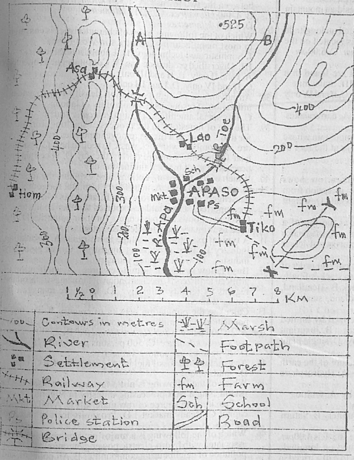
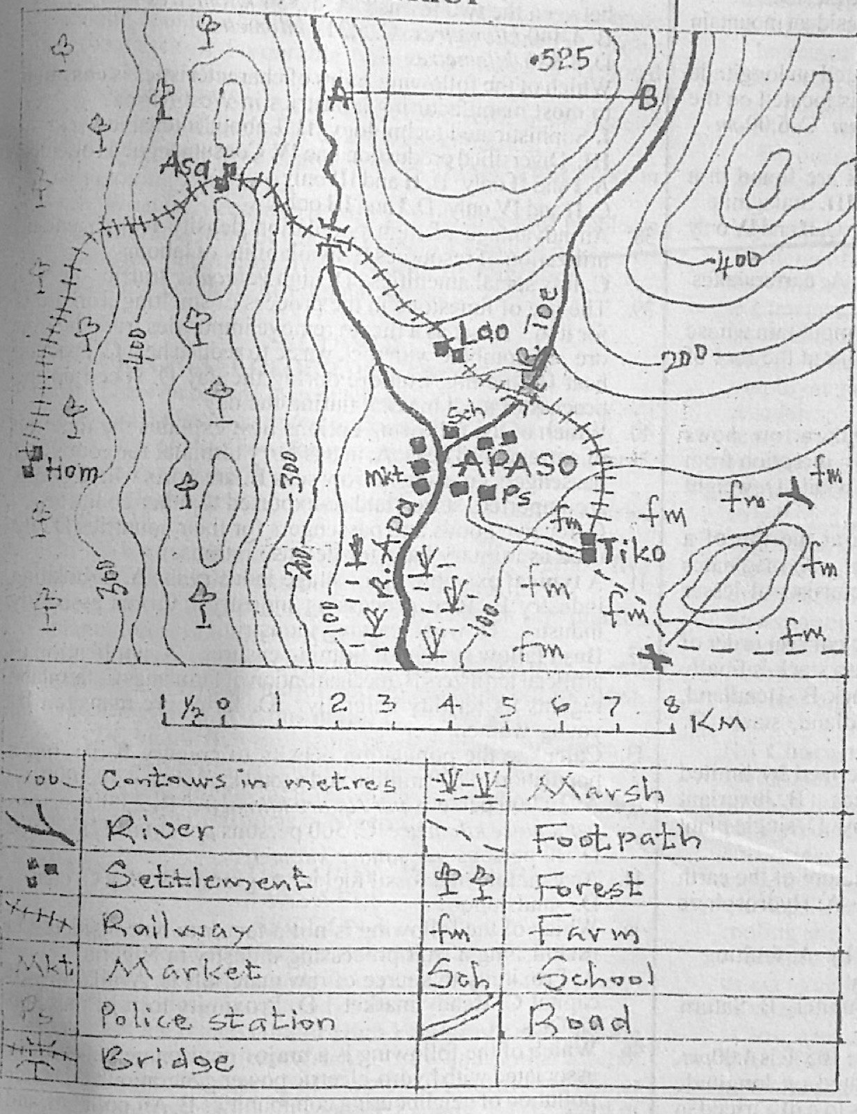
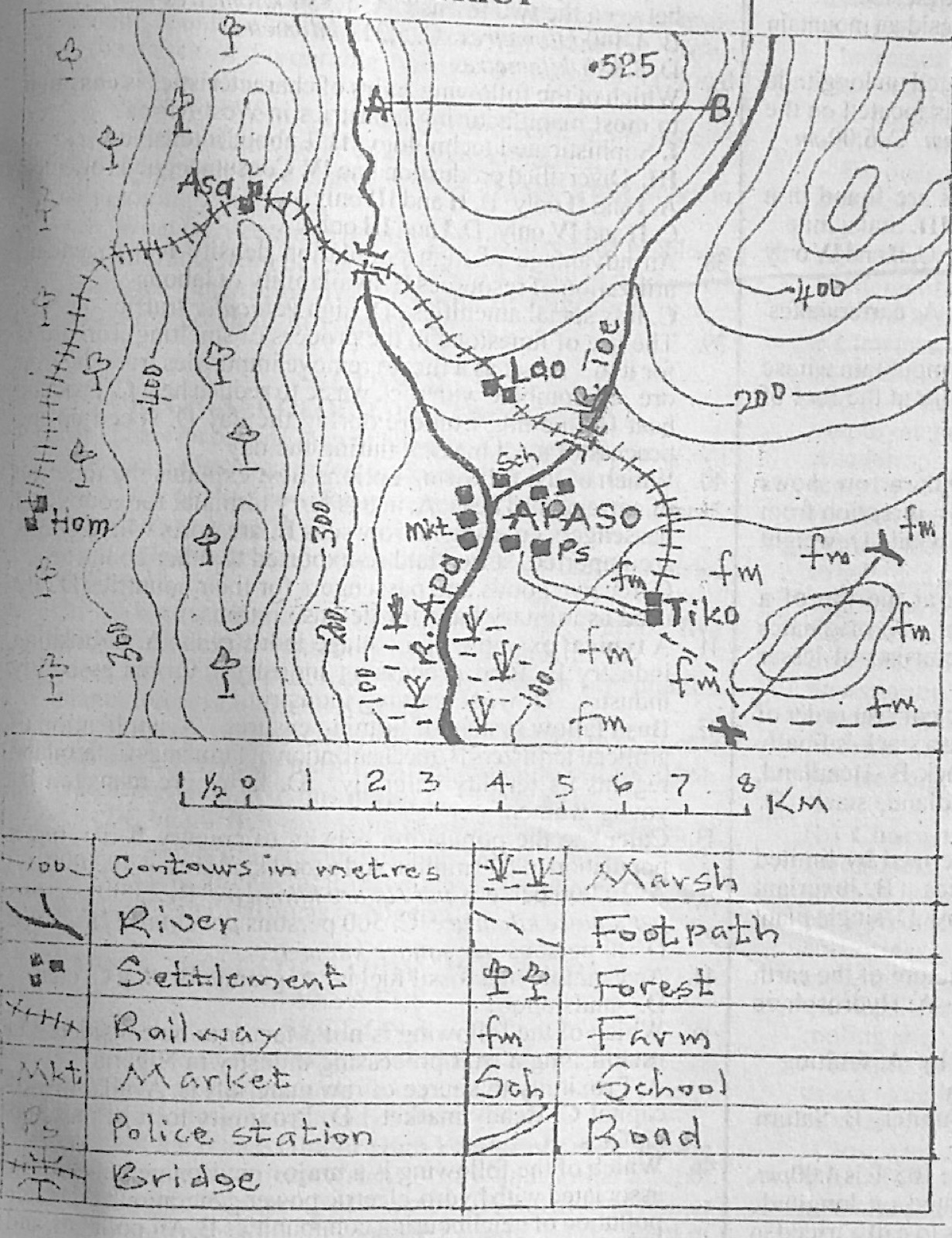
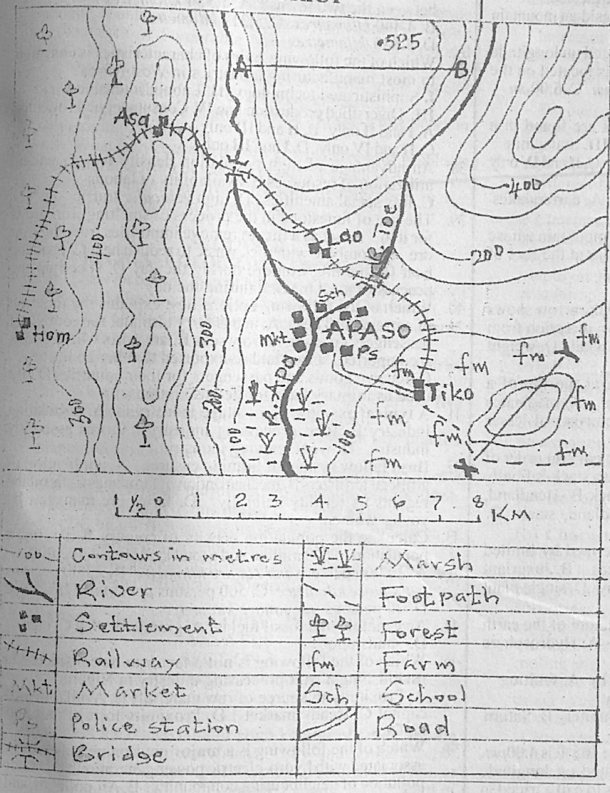
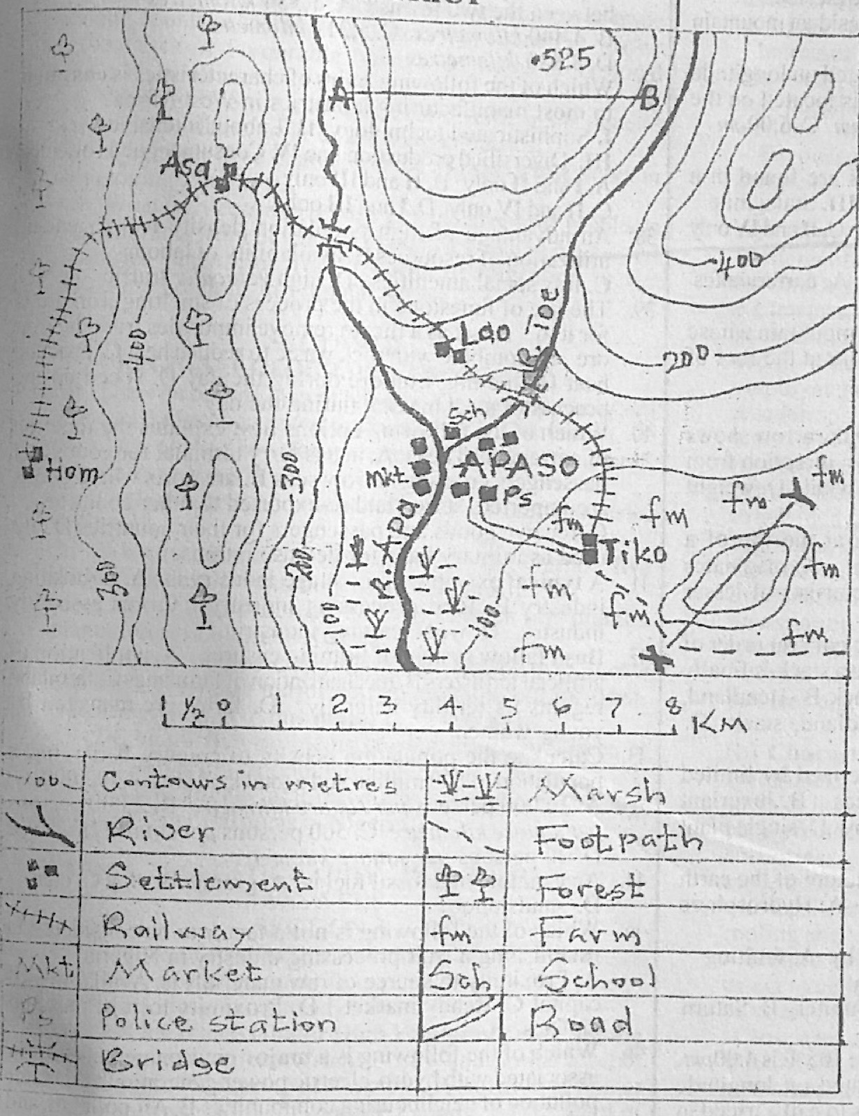
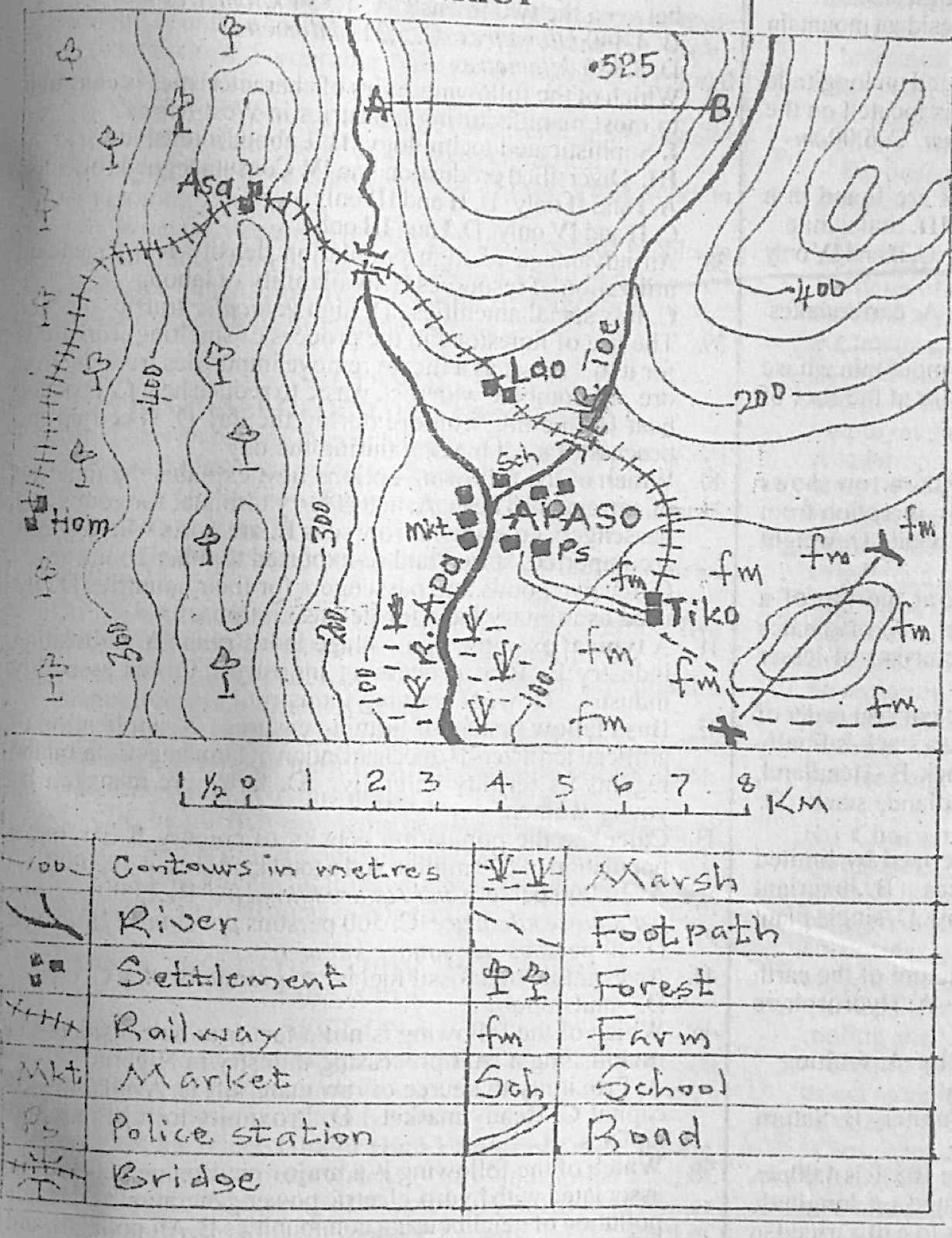
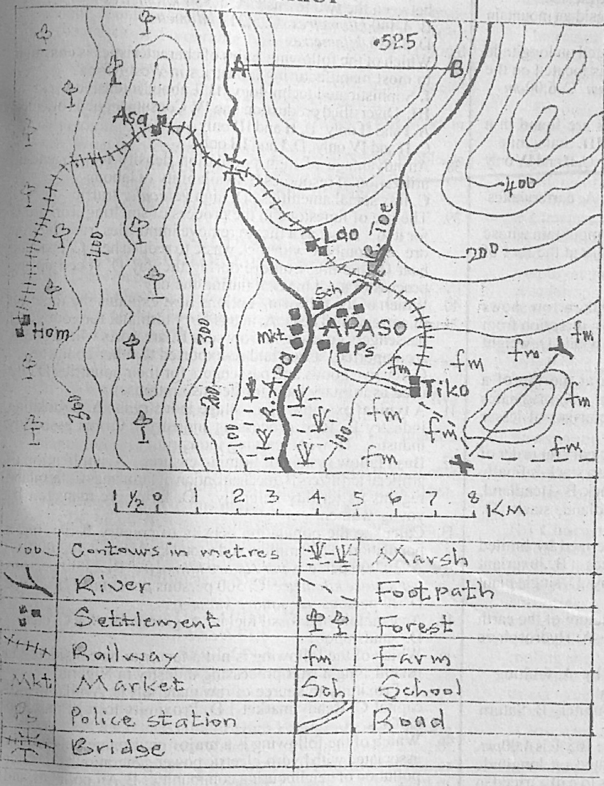
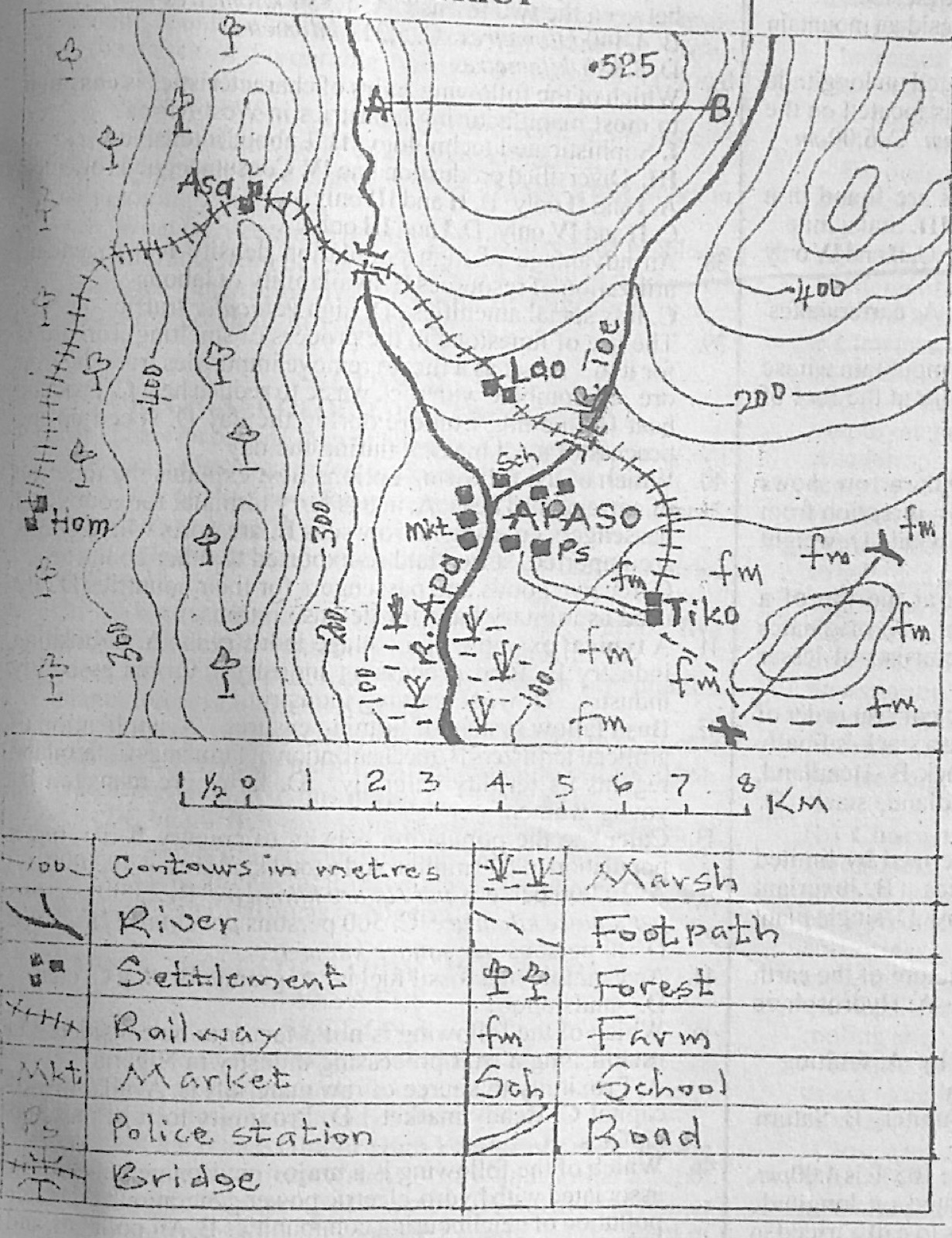
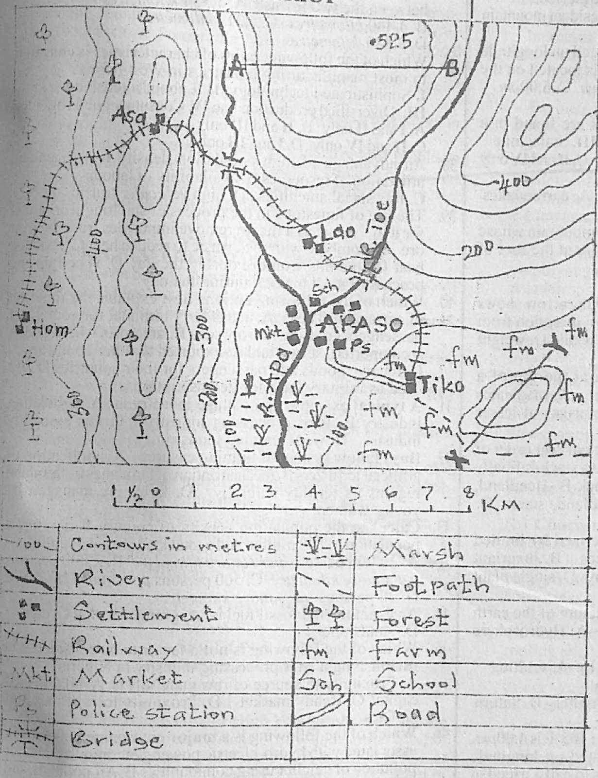
Study the map of APASO DISTRICT to answer this question. Which of the following methods of showing relief is represented by the symbol •525 in the mapped area?
Study the map of APASO DISTRICT to answer this question. The commodity that can best be transported from Hom to Asa based on the forest resources and the mode of transportation is
A.foodstuff
B.timber
C.rice
D.bauxite
Show the answer and explanation
Answer: B (timber)
Explanation
The railway from Hom to Asa runs through forest, so timber is the commodity carried.
Study the map of APASO DISTRICT to answer this question. Which of the following is the likely primary economic activity of the inhabitants of Tiko settlement?
Study the map of APASO DISTRICT to answer this question. APASO town can be described as a
A.linear settlement
B.harbour town
C.confluence town
D.terminal town
Show the answer and explanation
Answer: C (confluence town)
Explanation
R. Joe flows into R. Apa right beside APASO, so the town stands at a confluence (where two rivers meet). The railway does not end at APASO; it continues to Tiko.
The table below shows the temperature and rainfall distribution of station X. Use it to answer this question. Month: Jan, Feb, Mar, Apr, May, Jun, Jul, Aug, Sep, Oct, Nov, Dec Temperature (°C): 27, 28, 28, 28, 28, 26, 26, 25, 26, 26, 28, 28 Rainfall (mm): 30, 60, 120, 250, 280, 353, 400, 300, 450, 320, 100, 35 The annual range of temperature is
The table below shows the temperature and rainfall distribution of station X. Use it to answer this question. Month: Jan, Feb, Mar, Apr, May, Jun, Jul, Aug, Sep, Oct, Nov, Dec Temperature (°C): 27, 28, 28, 28, 28, 26, 26, 25, 26, 26, 28, 28 Rainfall (mm): 30, 60, 120, 250, 280, 353, 400, 300, 450, 320, 100, 35 What is the annual rainfall recorded at Station X?
The table below shows the temperature and rainfall distribution of station X. Use it to answer this question. Month: Jan, Feb, Mar, Apr, May, Jun, Jul, Aug, Sep, Oct, Nov, Dec Temperature (°C): 27, 28, 28, 28, 28, 26, 26, 25, 26, 26, 28, 28 Rainfall (mm): 30, 60, 120, 250, 280, 353, 400, 300, 450, 320, 100, 35 The type of climate represented by Station X is
A.Tropical continental
B.Hot desert
C.Mediterranean
D.equatorial
Show the answer and explanation
Answer: D (equatorial)
Explanation
High temperatures all year with a tiny range (3°C) and heavy rain (about 2,700 mm) in every month mean an equatorial climate.
Which of the following pairs are effects of rotation of the Earth? I. Day and night II. Phases of the moon III. Shape of the milky Way galaxy IV. Twilight
A.I and III only
B.I and IV only
C.II and III only
D.II and IV only
Show the answer and explanation
Answer: B (I and IV only)
Explanation
Rotation brings day and night and the gradual change between them (twilight); moon phases come from the moon's orbit.
"Sides are very steep, the top is almost flat and rises above lowlands on their sides". Which of the following types of mountain does the characteristics above describe?
A.Fold mountain
B.Block mountain
C.Residual mountain
D.Volcanic mountain
Show the answer and explanation
Answer: B (Block mountain)
Explanation
Steep fault scarps and a flat top describe a block mountain (horst).
Calculate the temperature at the peak of a mountain whose height is 8000 metres when the temperature at the foot of the same mountain is 8°C above sea level.
What will be the temperature at the peak of a mountain which is 3000 metres above the sea level if the temperature at the foot of the same mountain which is 1000 metres above the sea level is 26°C?
A.13°C
B.23°C
C.31°C
D.39°C
Show the answer and explanation
Answer: A (13°C)
Explanation
The climb is 2,000 m: 2 × 6.5 = 13°C fall; 26 − 13 = 13°C.
Lota and Babo towns lie along the same meridian. If Lota and Babo are located on latitudes 47°N and 33°S respectively, what is the approximate distance in kilometres between the two towns?
A.1,554 kilometres
B.4,440 kilometres
C.5,217 kilometres
D.8,880 kilometres
Show the answer and explanation
Answer: D (8,880 kilometres)
Explanation
Opposite hemispheres: 47 + 33 = 80° × 111 km = 8,880 km.
Which of the following pairs of characteristics is common to most manufacturing industries in West Africa? I. Sophisticated technology II. Labour intensive III. Diversified production line IV. Consumer goods oriented
A.I and II only
B.II and III only
C.II and IV only
D.I and III only
Show the answer and explanation
Answer: C (II and IV only)
Explanation
Most West African factories use much labour and make consumer goods (food, drinks, textiles).
(a) What is favourable balance of trade? (b) Outline five factors which hinder high volume of trade among countries in Tropical Africa. (c) Identify four advantages of favourable balance of trade in Tropical African countries
Show the model answer
Model answer
(a) A favourable balance of trade occurs when the value of a country's exports is greater than the value of its imports over a period. (b) Similar products (mainly primary goods); poor transport and communication links; different currencies and exchange problems; tariffs and trade barriers; political instability and conflicts; colonial ties to Europe; low purchasing power; language barriers; smuggling. (c) Increases foreign exchange reserves; strengthens the currency; more revenue for government; more jobs; funds for development; reduces foreign debt; encourages investment; raises standard of living.
(a) Identify five ways in which rural settlements depend on urban settlements in developing countries. (b) Highlight five characteristics of rural settlements in developing countries.
Show the model answer
Model answer
(a) Market for farm produce; supply of manufactured goods and farm inputs (fertilizer, tools); jobs for migrants; higher-order services (hospitals, banks, universities); administration and security; information, ideas and technology; transport terminals. (b) Small population and area; mainly primary occupations (farming, fishing); homogeneous people; buildings of local materials; few social amenities; dispersed or linear layout; simple, quiet life; communal land ownership; close social ties.
(a) What is forced migration? (b) Identify four problems that migrants from developing countries face in developed countries (c) Outline five benefits of migration to the destination regions in Tropical Africa.
Show the model answer
Model answer
(a) Forced migration is the movement of people who are compelled to leave their homes or countries because of threats to their safety or survival, e.g. war, persecution or natural disasters. (b) Unemployment or low-paid jobs; racial discrimination and xenophobia; housing problems; language barriers; culture shock and loneliness; non-recognition of certificates; risk of deportation; harsh climate. (c) Larger labour force; skilled manpower; larger market; growth of towns and infrastructure; new ideas and cultural exchange; more investment and trade; more tax revenue.
(a) Draw an outline map of Nigeria. On the map, show and name: (i) One area noted for local craft industries (ii) Kano (b) Explain four characteristics of local craft industries in Nigeria (c) Outline four economic benefits of local craft industries in Nigeria.
Show the model answer
Model answer
(a) Outline of Nigeria with title and north arrow; a craft area such as Kano/Bida (leather, brass, glass), Oyo/Iseyin (weaving, aso-oke), Benin (bronze casting), Akwete (cloth weaving) or Okigwe; Kano in the north. (b) Small scale, often at home; simple tools and hand skills; local raw materials; family or apprentice labour; little capital; skills passed down generations; low output for local markets. (c) Employment and income; use of local raw materials; preserve culture and attract tourists; earn foreign exchange from exports of crafts; reduce imports; training of apprentices; supplement farm incomes.
(a) What is plantation agriculture? (b) Outline five characteristics of plantation agriculture in Nigeria. (c) Identify four problems faced by farmers who practise plantation agriculture in Nigeria.
Show the model answer
Model answer
(a) Plantation agriculture is the large-scale cultivation of a single cash crop (e.g. oil palm, rubber, cocoa) on a large estate, mainly for export or industry. (b) Large land area; one main crop (monoculture); mainly cash/export crops; large capital; hired skilled and unskilled labour; scientific methods (fertilizers, improved seedlings, machines); processing on the estate; good management; often owned by companies or government. (c) High capital cost; land tenure problems; pests and diseases; fluctuating world prices; shortage of skilled labour; poor roads; labour disputes; competition from crude oil for labour and attention; insecurity.
(a) Draw an outline map of Nigeria. On the map, locate and name: (i) one major source region noted for rural-urban migration. (ii) one major town in 6(a)(i). (b) Highlight five problems created in urban centres in Nigeria as a result of population growth. (c) Outline three factors which account for the low population in rural areas in Nigeria.
Show the model answer
Model answer
(a) Outline of Nigeria with title and north arrow; a source region such as the densely settled south-east (Igboland), the Middle Belt or the north-western rural areas; a major town in it, e.g. Enugu, Owerri or Sokoto. (b) Unemployment; housing shortage and slums; traffic congestion; pressure on water, power, schools and hospitals; crime and social vices; pollution and waste disposal problems; high cost of living; spread of diseases. (c) Rural-urban migration; lack of jobs; poor social amenities (electricity, water, health care); poor roads; insecurity (banditry, farmer-herder clashes); low farm incomes; natural hazards (drought, floods, desertification).
(a) What is a metamorphic rock? (b) List two examples of metamorphic rocks (c) Outline five differences between a sedimentary rock and a metamorphic rock
Show the model answer
Model answer
(a) A metamorphic rock is a rock formed when an existing igneous or sedimentary rock is changed in form and composition by great heat and/or pressure. (b) Marble; slate; gneiss; schist; quartzite; graphite. (c) Sedimentary rocks form from deposited sediments, metamorphic from existing rocks changed by heat/pressure; sedimentary are stratified, metamorphic foliated or banded; sedimentary may contain fossils, metamorphic rarely; sedimentary are usually soft and porous, metamorphic hard and compact; sedimentary form at or near the surface, metamorphic deep in the crust or near intrusions; sedimentary are not crystalline, metamorphic often crystalline.
(a) Define the term weathering (b) Highlight three benefits of weathering to mankind. (c) Identify three factors which affect the rate of weathering.
Show the model answer
Model answer
(a) Weathering is the breakdown and decay of rocks in their original position by physical, chemical and biological processes. (b) Forms soil for agriculture; produces sand, gravel and clay for building; concentrates minerals (e.g. bauxite, laterite); creates attractive landforms for tourism; releases plant nutrients. (c) Climate (temperature and rainfall); rock type and mineral composition; rock structure (joints); relief and slope; vegetation and organisms; human activities; time.
(a) Define the term biosphere (b) Highlight four benefits of the biosphere (c) State five characteristics of the biosphere
Show the model answer
Model answer
(a) The biosphere is the zone of the earth where life exists, including parts of the lithosphere, hydrosphere and atmosphere. (b) Provides food; timber and fuel; medicines; oxygen from plants; raw materials for industry; recycles nutrients; supports tourism and recreation; regulates climate. (c) Contains all living organisms; overlaps the lithosphere, hydrosphere and atmosphere; a thin zone only a few kilometres thick; powered by energy from the sun; organisms interact in food chains and ecosystems; materials are recycled (water, carbon, nitrogen cycles); varies from place to place (biomes).
(a) What is an alluvial fan? (b) With the aid of a diagram, describe the characteristics and mode of formation of an alluvial fan.
Show the model answer
Model answer
(a) An alluvial fan is a fan-shaped deposit of sand, gravel and boulders laid down where a stream flows out of a steep mountain valley onto a flat plain. (b) Diagram: a mountain front, a stream leaving a narrow valley and a fan-shaped spread of deposits on the plain. Characteristics: fan or cone shaped; apex at the mouth of the valley; coarse material near the apex, finer towards the edge; streams divide into many channels; common in arid and semi-arid areas. Formation: a fast stream carries a heavy load down a steep slope; on reaching the gentle plain its gradient and speed drop suddenly; it deposits its load; channels become blocked and the stream shifts from side to side, spreading deposits in a fan; repeated deposition builds the fan up.
(a) Identify four factors which influence the amount of rainfall received in an area. (b) With the aid of a diagram, describe how latitude affects the temperature of a place.
Show the model answer
Model answer
(a) Latitude; distance from the sea; relief (windward or leeward side); prevailing winds and air masses; ocean currents; pressure belts (e.g. ITCZ); vegetation; altitude. (b) Diagram: globe with the sun's rays striking the equator vertically and the poles obliquely. In low latitudes the midday sun is high (overhead at some time of year), so its rays are concentrated on a small area and pass through a thin layer of atmosphere, giving high temperatures; towards the poles the rays are slanting, spread over a larger area and travel through more atmosphere, losing more heat, so temperatures are lower. Temperature therefore decreases from the equator to the poles.
(a) Define the term water resources (b) Identify three effects of water pollution (c) Outline three usefulness of water resources
Show the model answer
Model answer
(a) Water resources are sources of water useful to people and living things, such as rivers, lakes, seas, groundwater and rainfall. (b) Water-borne diseases (cholera, typhoid); death of fish and other aquatic life; shortage of clean drinking water; eutrophication; loss of income for fishermen; bad smell and ugliness. (c) Drinking and domestic use; irrigation; industry; hydroelectric power; fishing; transport; recreation and tourism.