WAEC Geography 2005 past questions and answers

65 questions. Try each one, then open the answer to check yourself and read the explanation.

Question 2

Map Scale, Distance and Direction

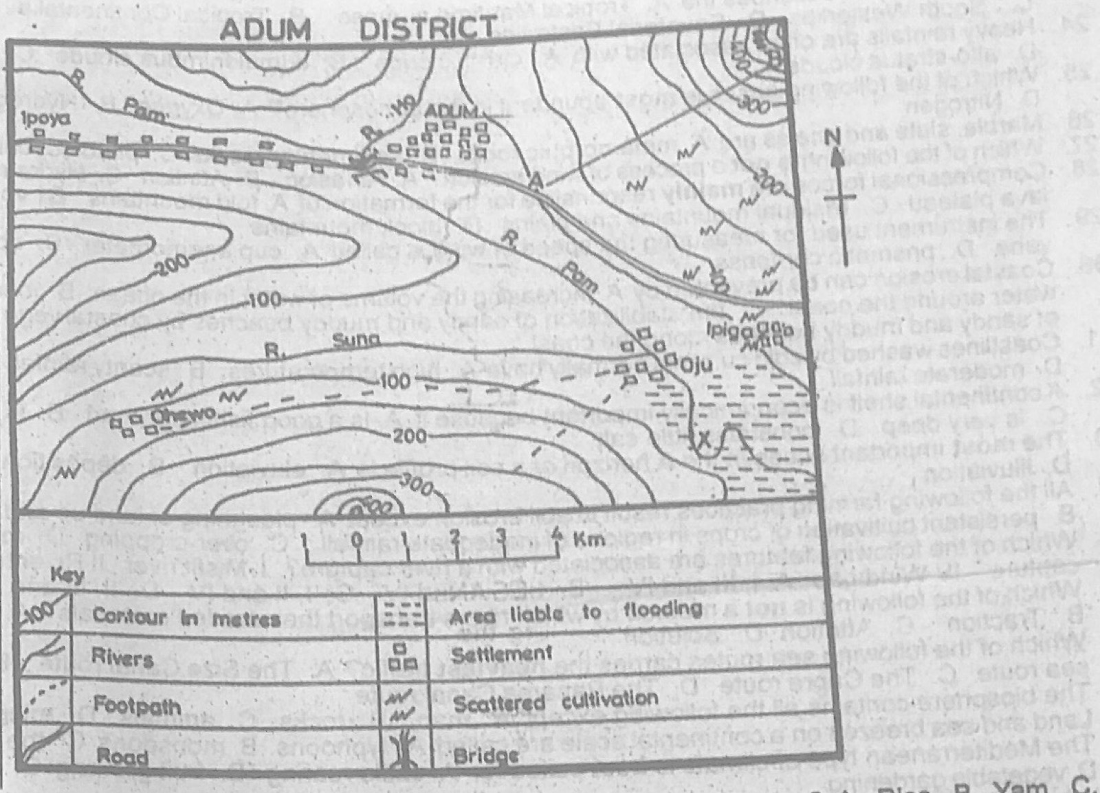
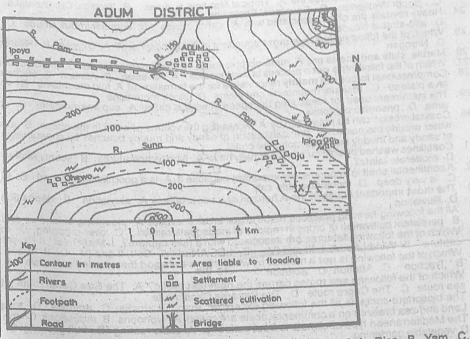
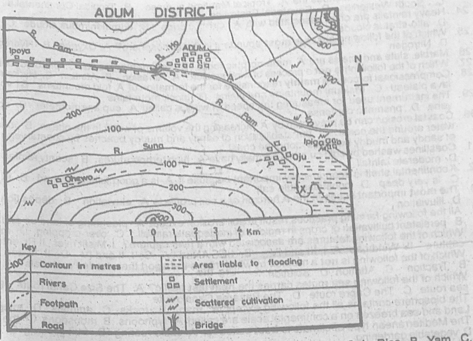
Study the map of ADUM DISTRICT to answer this question. The direction of Ohewo from Ipiga is

Diagram for this question
  1. A.North -East
  2. B.South-West
  3. C.North-West
  4. D.South-East
Show the answer and explanation

Answer: B (South-West)

Explanation

Ohewo lies to the west and slightly south of Ipiga, so it is south-west of Ipiga.

Open this question

Question 3

Relief and Map Interpretation

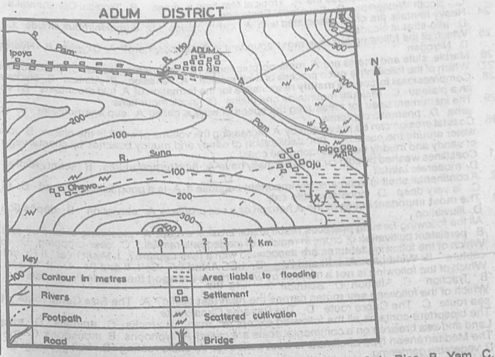
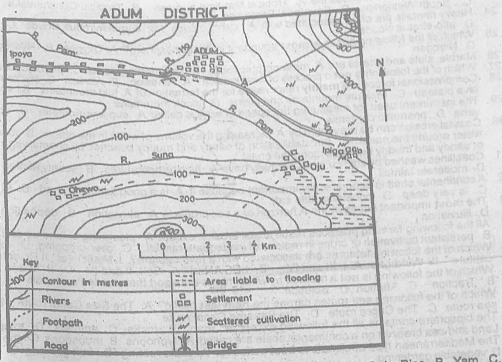
Study the map of ADUM DISTRICT to answer this question. Which of the following is a confluence town?

Diagram for this question
  1. A.Chewo
  2. B.Oju
  3. C.Ipoya
  4. D.Ipiga
Show the answer and explanation

Answer: B (Oju)

Explanation

Oju stands where streams join the main river.

Open this question

Question 4

Relief and Map Interpretation

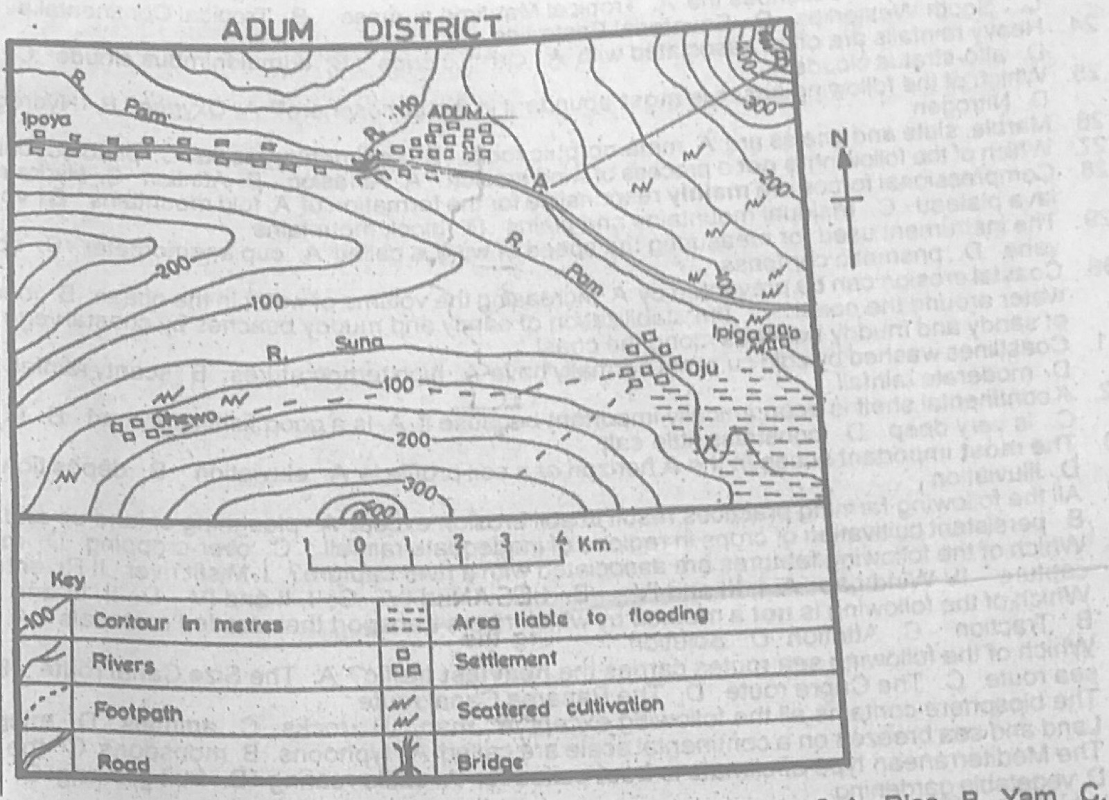
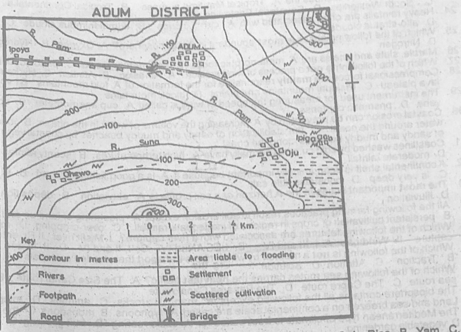
Study the map of ADUM DISTRICT to answer this question. Which of the following crops is likely to be cultivated in the are liable to flooding?

Diagram for this question
  1. A.Rice
  2. B.Yam
  3. C.Coca
  4. D.Groundnut
Show the answer and explanation

Answer: A (Rice)

Explanation

Rice needs waterlogged land, so it suits areas liable to flooding.

Open this question

Question 5

Relief and Map Interpretation

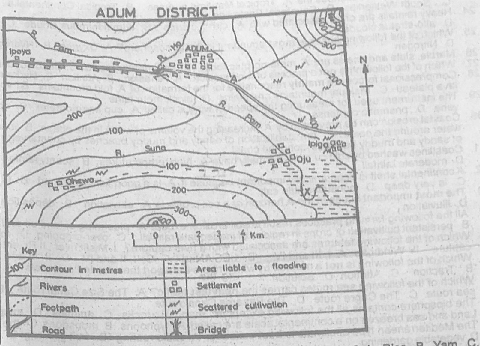
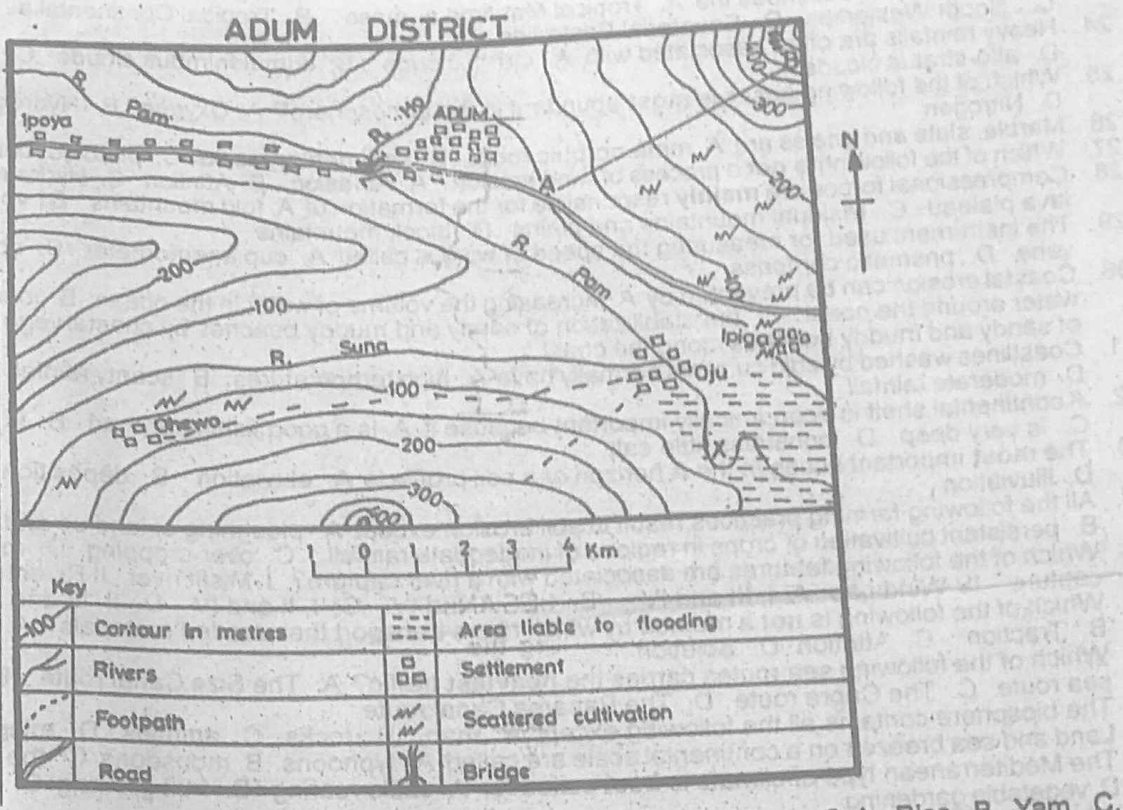
Study the map of ADUM DISTRICT to answer this question. The feature marked X can be described as

Diagram for this question
  1. A.an ox-bow lake
  2. B.a meander
  3. C.a spur
  4. D.a col
Show the answer and explanation

Answer: B (a meander)

Explanation

At X the river swings in a pronounced loop: a meander.

Open this question

Question 6

Relief and Map Interpretation

Study the map of ADUM DISTRICT to answer this question. The direction of flow of River Pam is

Diagram for this question
  1. A.North-West
  2. B.North-East
  3. C.South-West
  4. D.South-East
Show the answer and explanation

Answer: D (South-East)

Explanation

River Pam runs from Ipoya in the west past Adum and then turns south-east towards Ipiga and the flood plain.

Open this question

Question 7

Relief and Map Interpretation

Study the map of ADUM DISTRICT to answer this question. Then likely occupation of the people in Ipiga is

Diagram for this question
  1. A.fishing
  2. B.farming
  3. C.mining
  4. D.lumbering
Show the answer and explanation

Answer: B (farming)

Explanation

Scattered cultivation symbols surround Ipiga.

Open this question

Question 8

Relief and Map Interpretation

Study the map of ADUM DISTRICT to answer this question. The settlement of Ipoya can be described as

Diagram for this question
  1. A.linear
  2. B.clustered
  3. C.mucleated
  4. D.dispersed
Show the answer and explanation

Answer: A (linear)

Explanation

Ipoya's buildings stretch in a line along the road.

Open this question

Question 9

Relief and Map Interpretation

Study the map of ADUM DISTRICT to answer this question. The feature marked A - B can best be described as

Diagram for this question
  1. A.concave slope
  2. B.scarp slope
  3. C.dip slope
  4. D.convex slope
Show the answer and explanation

Answer: A (concave slope)

Explanation

From A to B the contours are wide apart at the bottom and close together near the top, so the slope is gentle below and steep above: concave.

Open this question

Question 10

Map Scale, Distance and Direction

Study the map of ADUM DISTRICT to answer this question. The bearing of Ohewo from Adum is approximately

Diagram for this question
  1. A.225°
  2. B.265°
  3. C.270°
  4. D.275°
Show the answer and explanation

Answer: A (225°)

Explanation

Ohewo lies south-west of Adum, about equally far south as west, so its bearing is about 225°.

Open this question

Question 11

Climate

Use the table for a station: Month J F M A M J J A S O N D; Temperature (°C) 22, 22, 23, 24, 28, 30, 31, 31, 29, 30, 24, 24; Rainfall (mm) 32.5, 52.0, 132, 225, 270, 310, 354, 416, 221, 31.0, 11, 02.1. The annual range of temperature for the station is

Diagram for this question
  1. A.6°C
  2. B.9°C
  3. C.11°C
  4. D.12°C
Show the answer and explanation

Answer: B (9°C)

Explanation

Range = highest (31°C) − lowest (22°C) = 9°C.

Open this question

Question 12

Climate

Use the table for a station: Month J F M A M J J A S O N D; Temperature (°C) 22, 22, 23, 24, 28, 30, 31, 31, 29, 30, 24, 24; Rainfall (mm) 32.5, 52.0, 132, 225, 270, 310, 354, 416, 221, 31.0, 11, 02.1. Which of the following pairs of weather instruments were used to collect the data for the station?

Diagram for this question
  1. A.A rain gauge and an anemometer
  2. B.A wind vane and a thermometer
  3. C.A thermometer and a rain gauge
  4. D.A barometer and a rain gauge
Show the answer and explanation

Answer: C (A thermometer and a rain gauge)

Explanation

The table gives temperature (thermometer) and rainfall (rain gauge).

Open this question

Question 13

Latitude, Longitude and Time

What is the approximate distance of town X from the equator, if it is located on latitude 14°N?

  1. A.1555 km
  2. B.1232 km
  3. C.441 km
  4. D.42 km
Show the answer and explanation

Answer: A (1555 km)

Explanation

Each degree of latitude is about 111 km: 14 × 111 ≈ 1555 km.

Open this question

Question 14

Weather

When a warm ocean current meets a cold ocean current, they produce

  1. A.mist
  2. B.line squall
  3. C.fog
  4. D.hail
Show the answer and explanation

Answer: C (fog)

Explanation

Warm moist air over the warm current is chilled by the cold water, causing fog (as off Newfoundland).

Open this question

Question 15

The Earth and Solar System

The distance of Planet Mercury from the sun is about

  1. A.40 million km
  2. B.50 million km
  3. C.57 million km
  4. D.60 million km
Show the answer and explanation

Answer: C (57 million km)

Explanation

Mercury's average distance from the sun is about 58 million km.

Open this question

Question 16

The Earth and Solar System

The most distant planet from us is

  1. A.Neptune
  2. B.Mars
  3. C.Earth
  4. D.Pluto
Show the answer and explanation

Answer: D (Pluto)

Explanation

Pluto (then counted as a planet) is the farthest from the sun and the earth.

Open this question

Question 17

The Earth and Solar System

Which of the following is not a proof that the earth is spherical?

  1. A.The circular horizon
  2. B.Sunrise and sunset
  3. C.Varying lengths of day and night
  4. D.Driving poles on a level ground
Show the answer and explanation

Answer: C (Varying lengths of day and night)

Explanation

Varying lengths of day and night result from the tilt of the axis and revolution, not from the earth's shape.

Open this question

Question 18

The Earth and Solar System

The latitudes which mark the limits of the apparent movement of the overhead sun are the

  1. A.Tropic of Cancer and the Arctic Circle
  2. B.Arctic and Antartic Circles
  3. C.Tropics of Cancer and Capricorn
  4. D.Equator and the Arctic circle
Show the answer and explanation

Answer: C (Tropics of Cancer and Capricorn)

Explanation

The overhead sun moves between 23½°N and 23½°S.

Open this question

Question 19

Weathering, Erosion and Mass Movement

Weathering, erosion, transportation and deposition are processes of

  1. A.mass wasting
  2. B.vulcanicity
  3. C.denudation
  4. D.exfoliation
Show the answer and explanation

Answer: C (denudation)

Explanation

Denudation is the general wearing down of the land by all these processes.

Open this question

Question 20

Oceans and Lakes

Which of the following factors does not affect the salinity of the oceans?

  1. A.Rate of evaporaiton
  2. B.Degree of water mixing by currents
  3. C.Amount of fresh water added by rain
  4. D.Shape of the ocean floor
Show the answer and explanation

Answer: D (Shape of the ocean floor)

Explanation

Salinity depends on evaporation, fresh-water inflow and mixing; the shape of the ocean floor does not change it.

Open this question

Question 21

Weather

Six's thermometer is used to measure

  1. A.maximum temperature
  2. B.minimum temperature
  3. C.minimum and maximum temperature
  4. D.average temperature
Show the answer and explanation

Answer: C (minimum and maximum temperature)

Explanation

Six's thermometer records both the highest and lowest temperatures reached.

Open this question

Question 22

Weather

The maximum temperature recorded for Station X in a particular day was 14°C while the minimum temperature was - 4°C. The diural range of temperature for the day was

  1. A.5°C
  2. B.9°C
  3. C.12°C
  4. D.18°C
Show the answer and explanation

Answer: D (18°C)

Explanation

Range = 14 − (−4) = 18°C.

Open this question

Question 23

Weather

"It is warm and dusty, originates from the Sahara and reaches its lowest southward extent in the January". The above text describes the

  1. A.Tropical Maritime airmass
  2. B.Tropical Continental airmass
  3. C.South Westerlies
  4. D.Equatorial Easterlies
Show the answer and explanation

Answer: B (Tropical Continental airmass)

Explanation

The dry, dusty harmattan from the Sahara is the tropical continental air mass, which reaches farthest south in January.

Open this question

Question 24

Weather

Heavy rainfalls are often associated with

  1. A.cirrus clouds
  2. B.cumulonimbus clouds
  3. C.nimbostratus clouds
  4. D.alto-stratus clouds
Show the answer and explanation

Answer: B (cumulonimbus clouds)

Explanation

Towering cumulonimbus clouds give heavy showers and thunderstorms.

Open this question

Question 25

Structure of the Earth

Which of the following gases is most abundant in the atmosphere?

  1. A.Oxygen
  2. B.Hydrogen
  3. C.Argon
  4. D.Nitrogen
Show the answer and explanation

Answer: D (Nitrogen)

Explanation

Nitrogen makes up about 78% of the air.

Open this question

Question 26

Rocks

Marble, slate and gneiss are

  1. A.metamorphic rocks
  2. B.sedimentary rocks
  3. C.plutonic rocks
  4. D.volcanic rocks
Show the answer and explanation

Answer: A (metamorphic rocks)

Explanation

All three form when existing rocks are changed by heat and pressure.

Open this question

Question 27

Wind and Desert Landforms

Which of the following is not a process of wind erosion?

  1. A.Abrasion
  2. B.Attrition
  3. C.Hydraulic action
  4. D.Deflation
Show the answer and explanation

Answer: C (Hydraulic action)

Explanation

Hydraulic action is the force of moving water, not wind.

Open this question

Question 28

Earth Movements and Vulcanicity

Compressional forces are mainly responsible for the formation of

  1. A.fold mountains
  2. B.volcanic mountians and lava plateau
  3. C.residual mountains and plains
  4. D.block mountains
Show the answer and explanation

Answer: A (fold mountains)

Explanation

Compression squeezes rock layers into folds.

Open this question

Question 29

Weather

The instrument used for measuring the speed of wind is called

  1. A.cup anemometer
  2. B.speedometer
  3. C.wind vane
  4. D.prismatic compass
Show the answer and explanation

Answer: A (cup anemometer)

Explanation

A cup anemometer measures wind speed; a wind vane shows direction.

Open this question

Question 30

Coastal Landforms

Coastal erosion can be prevented by

  1. A.increasing the volume of water in the ocean
  2. B.increasing the volume of water around the coast
  3. C.the stabilization of sandy and muddy beaches by coastal vegetation
  4. D.the removal of sandy and muddy beaches along the coast
Show the answer and explanation

Answer: C (the stabilization of sandy and muddy beaches by coastal vegetation)

Explanation

Plants hold beach sand and mud together so waves remove less of it.

Open this question

Question 31

Oceans and Lakes

Coastlines washed by cold currents normally have

  1. A.high temperatures
  2. B.scanty rainfall
  3. C.excessive rainfall
  4. D.moderate rainfall
Show the answer and explanation

Answer: B (scanty rainfall)

Explanation

Cold currents cool and stabilise the air, so little rain falls (e.g. Namib coast).

Open this question

Question 32

Oceans and Lakes

A continental shelf is economically important because it

  1. A.is a good fishing ground
  2. B.is good for irrigation
  3. C.is very deep
  4. D.constains little salt
Show the answer and explanation

Answer: A (is a good fishing ground)

Explanation

Shallow, sunlit shelf waters are rich in plankton and fish.

Open this question

Question 33

Soils

The most important action in the A horizon of a soil profile is

  1. A.eluviation
  2. B.deposition
  3. C.weathering
  4. D.illuviation
Show the answer and explanation

Answer: A (eluviation)

Explanation

In the A horizon water washes minerals downwards (eluviation); they collect in the B horizon (illuviation).

Open this question

Question 34

Environmental Hazards and Conservation

All the following farming practices result in soil erosion except

  1. A.ploughing of land up and down slope
  2. B.persistent cultivation of crops in regions of inadequate rainfall
  3. C.over-cropping
  4. D.mixed cropping
Show the answer and explanation

Answer: D (mixed cropping)

Explanation

Mixed cropping keeps the ground covered and protects the soil.

Open this question

Question 35

Rivers and River Landforms

Which of the following features are associated with a river capture? I Misfit river II River terraces III Elbow of capture IV Wind gap

  1. A.I, III and IV
  2. B.I, II, III and IV
  3. C.I, II and IV
  4. D.II, III and IV
Show the answer and explanation

Answer: A (I, III and IV)

Explanation

River capture leaves an elbow of capture, a misfit (beheaded) stream and a dry wind gap; terraces come from rejuvenation.

Open this question

Question 36

Rivers and River Landforms

Which of the following is not a method by which rivers transport their eroded materials?

  1. A.Suspension
  2. B.Traction
  3. C.Attrition
  4. D.Solution
Show the answer and explanation

Answer: C (Attrition)

Explanation

Attrition is wearing down of the load by collision (erosion), not a way of carrying it.

Open this question

Question 37

Transport, Trade and Tourism

Which of the following sea routes carries the heaviest traffic?

  1. A.The Size Canal route
  2. B.The North Atlantic sea route
  3. C.The Capre route
  4. D.The Panama Canal route
Show the answer and explanation

Answer: B (The North Atlantic sea route)

Explanation

The North Atlantic route links the industrial regions of Western Europe and North America and carries the most traffic.

Open this question

Question 38

Structure of the Earth

The biosphere contains all the following except

  1. A.man
  2. B.rocks
  3. C.animals
  4. D.micro-organisms
Show the answer and explanation

Answer: B (rocks)

Explanation

The biosphere is the zone of living things; rocks belong to the lithosphere.

Open this question

Question 39

Weather

Land and sea breezes on a continental scale are called

  1. A.typhoons
  2. B.monsoons
  3. C.the Fohn
  4. D.the chinook
Show the answer and explanation

Answer: B (monsoons)

Explanation

Monsoons are seasonal reversals of wind caused by the differential heating of continents and oceans.

Open this question

Question 40

Agriculture, Fishing and Lumbering

The Mediterranean type of climate is best suited for

  1. A.cattle rearing
  2. B.fruit growing
  3. C.rice cultivation
  4. D.vegetable gardening
Show the answer and explanation

Answer: B (fruit growing)

Explanation

Hot dry sunny summers ripen citrus, grapes and olives.

Open this question

Question 41

Vegetation

Which of the following vegetation types is associated with the sub-equatorial type of climate?

  1. A.Rain forest
  2. B.Steppe
  3. C.Montane
  4. D.Pampas
Show the answer and explanation

Answer: A (Rain forest)

Explanation

The sub-equatorial (Guinea coast) climate has heavy rain and high temperature, which support rain forest.

Open this question

Question 42

The Ecosystem

Which of the following shows the correct sequence in food chain?

  1. A.Herbivores → carnivores→ decomposer → plants
  2. B.Carnivores → decomposers → herbivores → plants
  3. C.Plants → herbivores → carnivores → decomposers
  4. D.Decomposers → herbivores → plants → carnivores
Show the answer and explanation

Answer: C (Plants → herbivores → carnivores → decomposers)

Explanation

Energy flows from plants to plant-eaters, then to flesh-eaters, and decomposers break down dead matter.

Open this question

Question 43

Manufacturing Industry

One of the major characteristics of heavy industries is that they

  1. A.need low skilled man power
  2. B.are mainly concentrated in the rural areas
  3. C.need mainly female labour force
  4. D.require high capital outlay
Show the answer and explanation

Answer: D (require high capital outlay)

Explanation

Heavy industries need huge investment in plant and machinery.

Open this question

Question 44

Transport, Trade and Tourism

A country is said to be land-locked when

  1. A.she experiences a free flow of traffic
  2. B.her waterways are frozen in winter
  3. C.she experiences a lot of traffic congestion
  4. D.she has no direct access to the sea
Show the answer and explanation

Answer: D (she has no direct access to the sea)

Explanation

A land-locked country has no coastline.

Open this question

Question 45

Mining and Energy

Which of the following is a major hinderance to HEP production in Africa?

  1. A.Inadequate capital
  2. B.Unavailibity of good sites
  3. C.Absence of a domestic market
  4. D.Sufficient volume of water
Show the answer and explanation

Answer: A (Inadequate capital)

Explanation

Africa has many good sites and rivers, but building dams and power stations needs capital that is scarce.

Open this question

Question 46

Transport, Trade and Tourism

One advantage of inland water-ways is that

  1. A.they are flexible
  2. B.they are fast
  3. C.goods are transported cheaply
  4. D.river, at time, flow through areas of limited commerical value
Show the answer and explanation

Answer: C (goods are transported cheaply)

Explanation

Water is a natural route needing little upkeep, so bulky goods move cheaply.

Open this question

Question 47

Population

Which of the following is a demerit of low population density?

  1. A.Low crime rate
  2. B.High per capita income
  3. C.Inadequate labour force
  4. D.Low pressure on social amenities
Show the answer and explanation

Answer: C (Inadequate labour force)

Explanation

Too few people means a shortage of workers to develop resources.

Open this question

Question 48

Geography of Africa

The most difficult problem facing lumbering in Zaire is that the

  1. A.woods are too hard and difficult to process
  2. B.logs are too heavy to be moved to the sawmills
  3. C.economic trees are not found in pure stands
  4. D.other countries are competing with Zaire in lumbering activities
Show the answer and explanation

Answer: C (economic trees are not found in pure stands)

Explanation

Useful trees are scattered among many other species, so finding and extracting them is costly.

Open this question

Question 49

Vegetation

Which of the following vegetation types is found only in the Northern hemisphere?

  1. A.Tropical grassland
  2. B.Equatorial forest
  3. C.Tundra
  4. D.Mediterranean
Show the answer and explanation

Answer: C (Tundra)

Explanation

Tundra occurs along the Arctic fringes; there is almost no comparable land at those latitudes in the southern hemisphere.

Open this question

Question 50

Population

One effects of rural-urban migration on the source region is

  1. A.rapid urbanization
  2. B.intensive pressure on land-use in rural areas
  3. C.rural depopulation
  4. D.urban depopulation
Show the answer and explanation

Answer: C (rural depopulation)

Explanation

Villages lose people, especially young adults, when they move to towns.

Open this question

Theory question 101

Transport, Trade and Tourism

(a) Highlight three advantages and three disadvantages of water transport. (b) Explain any four factors that hinder the use of water transport.

Show the model answer
Model answer

(a) Advantages: cheapest way to carry bulky goods over long distances; natural routes need little maintenance; carries very large loads; relatively safe; links countries and continents. Disadvantages: slow; not flexible (only where there is water, not door to door); high cost of ships and ports; affected by weather and seasons; unsuitable for perishable goods without refrigeration.
(b) Seasonal flow of rivers (low water in the dry season); rapids, waterfalls and cataracts; floating weeds (water hyacinth); silting and sandbars at river mouths and harbours; frozen waterways in winter; shallow and narrow channels; lack of capital for ports and dredging; insecurity.

Explanation

Explain how each factor stops boats moving.

Open this question

Theory question 102

Settlement

(a) Explain the term settlement. (b) Describe four characteristics of an urban settlement. (c) Outline four functions which an urban settlement can perform for a rural settlement.

Show the model answer
Model answer

(a) A settlement is a place where people live and carry out activities, made up of buildings and the routes linking them; it ranges from a single homestead to a city.
(b) Large population and high density; most people work in secondary and tertiary jobs; many social amenities (schools, hospitals, water, electricity); well-planned roads and transport; tall buildings and varied land use; heterogeneous population; administrative and commercial functions.
(c) Market for farm produce; supply of manufactured goods; services such as hospitals, secondary schools and banks; employment; administration; spread of innovation and information; transport links.

Explanation

Contrast urban features with rural ones.

Open this question

Theory question 103

Population

(a) Define the following terms: (i) optimum population; (ii) over-population; (iii) population density; (b) The total population of country Q in the year 1998 was 4 million. If the land area of country Q is 400,000 km2, calculate the population density of country Q. (c) Highlight four disadvantages of the population density calcuated in 3(b) above on the economy of country Q.

Show the model answer
Model answer

(a)(i) Optimum population is the number of people that, with the available resources and technology, gives the highest possible standard of living.
(ii) Over-population is when the population is too large for the available resources, so living standards fall.
(iii) Population density is the average number of people per unit area (persons per km²).
(b) 4,000,000 ÷ 400,000 = 10 persons per km².
(c) The low density means: shortage of labour; resources left undeveloped; small home market for industries; high cost of providing roads, schools and other services to scattered people; low government revenue; difficulty in defence and administration.

Explanation

Density = population ÷ area, with units.

Open this question

Theory question 104

Nigeria: Physical Setting

For candidates in Nigeria: (a) Draw an outline map of Nigeria. On the map, locate and name; (i) the Gulf of Guinea; (ii) the Bight of Bonny; (iii) latitude 14°N; (iv) the country to the Western border; (v) the Federal Capital Territory. (b) Describe the size and location if Nigeria in relation to other countries of West Africa.

Show the model answer
Model answer

(a) Gulf of Guinea south of Nigeria; Bight of Bonny in the south-east (off Port Harcourt/Calabar); latitude 14°N along the northern border with Niger; Republic of Benin on the western border; FCT (Abuja) in the centre.
(b) Size: about 923,768 km²; one of the largest countries in West Africa (about one-seventh of the region's area), larger than Ghana several times; the most populous country in Africa. Location: between latitudes 4°N and 14°N and longitudes 3°E and 15°E; in the eastern part of West Africa; bordered by Benin (west), Niger (north), Chad (north-east), Cameroon (east) and the Atlantic/Gulf of Guinea (south).

Explanation

Give both latitude-longitude position and neighbouring countries.

Open this question

Theory question 105

Nigeria: People and Economy

For candidates in Nigeria: (a) Draw a sketch map of Nigeria. On the map, locate and name' (i) the Mid-West industrial zone; (ii) the South-East industrial zone; (iii) the North-Central industrial zone; (iv) one important town in each zone in 5(a)(i) – (iii) above. (b) Highlight three problems facing manufacturing industries in Nigeria. (c) Suggest solutions to any two of the problems highlighted in 5(b) above.

Show the model answer
Model answer

(a) Mid-West: Benin City, Warri, Sapele; South-East: Port Harcourt, Aba, Onitsha, Enugu; North-Central: Kaduna, Jos, Zaria, Kano.
(b) Erratic power supply; inadequate capital; poor transport; shortage of raw materials and spare parts; shortage of skilled labour; competition from imports; low purchasing power; political instability and insecurity; poor management.
(c) Improve and diversify power supply; provide loans and attract investment; improve roads and railways; develop local sources of raw materials; train workers; ban or tax competing imports; good governance and security.

Explanation

Make each solution match one named problem.

Open this question

Theory question 106

Nigeria: People and Economy

For candidates in Nigeria: (a) Draw a sketch map of Nigeria. On the map, locate and name; (i) The Eastern Railway Line; (ii) four major stations along the railway line in 6(a)(i) above. (b) Outline three advantages of rail transportation in Nigeria. (c) Highlight three limitations of rail transportation in Nigeria.

Show the model answer
Model answer

(a) Eastern line: Port Harcourt-Aba-Umuahia-Enugu-Makurdi-Lafia-Kafanchan-Kaduna (branch Kafanchan-Jos-Bauchi-Gombe-Maiduguri); stations e.g. Port Harcourt, Aba, Umuahia, Enugu, Makurdi, Kafanchan.
(b) Carries bulky goods cheaply over long distances; carries many passengers at low fares; relatively safe; reduces pressure on roads; links producing areas with ports; less affected by weather.
(c) Narrow gauge and slow trains; inadequate and old engines and coaches; poor maintenance; limited network not reaching many areas; not flexible (no door-to-door service); poor management; competition from road transport.

Explanation

Mark the line with cross-ticks and name the stations in order.

Open this question

Theory question 107

Geography of Africa

(a) Draw a sketch map of Africa. On the map, show and name one area of any two of the following (i) Equatorial climate; (ii) Mediterranean climate; (iii) Hot Desert climate; (iv) Tropical Continental climate (b) Highlight four characteristics of the Equatorial climate (c) Outline three ways in which forest vegetation is of economic importance in Africa

Show the model answer
Model answer

(a) Equatorial: Congo Basin, Guinea coast; Mediterranean: north-west Africa (Algeria, Tunisia, Morocco) or the south-west Cape; hot desert: Sahara, Kalahari/Namib; tropical continental: savanna belt of West Africa and Sudan.
(b) High temperature all year (about 27°C); small annual range (2-3°C); heavy rainfall (over 1,500-2,000 mm) well spread through the year with double maxima; high humidity; convectional thunderstorms in the afternoon; no real dry season.
(c) Timber for export and local use; raw materials for industries (plywood, pulp, furniture); fuelwood and charcoal; food, medicine and fruits; employment; habitat for wildlife and tourism; foreign exchange.

Explanation

Shade climate regions clearly with a key.

Open this question

Theory question 108

Agriculture, Fishing and Lumbering

(a) List three plantation crops in Africa. (b) Outline four ways in which plantation agriculture is important. (c) Highlight three differences between plantation agriculture in West Africa and East Africa.

Show the model answer
Model answer

(a) Rubber, oil palm, cocoa, tea, coffee, sisal, sugarcane, bananas, tobacco.
(b) Earns foreign exchange; provides employment; raw materials for industries; government revenue; brings in modern methods and research; development of infrastructure (roads, housing, hospitals) in rural areas; improved quality of produce.
(c) West Africa: mostly owned by governments or Africans and smaller in size; East Africa: largely established by Europeans (settlers) and very large estates. West Africa grows rubber, oil palm, cocoa; East Africa grows tea, coffee, sisal, pyrethrum. West Africa plantations in lowland forest; East Africa on cooler highlands. Fewer plantations in West Africa because of tsetse, land tenure and climate; East Africa had more foreign capital.

Explanation

Compare ownership, crops and location in (c).

Open this question

Theory question 109

Geography of Africa

(a) Draw an outline map of Africa. On the map, locate and name, (i) one are important for the mining of each of coal, diamond and gold; (ii) one important town in two of the areas in 9(a)(i) above (b) Highlight three ways in which the minerals in (a)(i) above are of economic importance to Africa. (c) Outline two problems associated with mining in Africa.

Show the model answer
Model answer

(a) Coal: Enugu (Nigeria), Witbank (South Africa), Hwange/Wankie (Zimbabwe); diamond: Kimberley (South Africa), Kasai/Mbuji-Mayi (DR Congo), Sierra Leone (Koidu), Botswana (Orapa); gold: Witwatersrand (Johannesburg), Obuasi/Tarkwa (Ghana).
(b) Foreign exchange; government revenue; employment; raw materials and energy for industry (coal for power and steel); growth of towns and infrastructure; attracts investment.
(c) Land degradation and pollution; lack of capital and technology; exhaustion of deposits; fall in world prices; poor transport; smuggling and illegal mining; labour unrest and mining accidents.

Explanation

Give a named area and town for each mineral.

Open this question

Theory question 202

Surveying

(a) Explain the term error of closure. (b) Highlight any four sources of error of closure in closed traverse survey. (c) Outline two measures that could be taken to avoid an error of closure.

Show the model answer
Model answer

(a) Error of closure is the gap between the starting point and the finishing point of a closed traverse when it is plotted, showing that the traverse fails to close exactly on its origin.
(b) Inaccurate measurement of lengths; wrong reading or booking of bearings; faulty or badly set instruments; local magnetic attraction (iron objects, power lines) deflecting the compass; errors in plotting (scale, protractor); sagging or stretched tape.
(c) Check and calibrate instruments before use; take forward and back bearings to check readings; measure each line twice; keep magnetic materials away from the compass; plot carefully and check booking.

Explanation

Define the error, then list causes and the checks that prevent them.

Open this question

Theory question 203

Latitude, Longitude and Time

(a) If the time in London is 08.00 hours GMT and the local time in Addis Ababa is 12.00 noon on what longitude is Addis Ababa? (b) Write explanatory notes on the following: (i) Time zones; (ii) Standard Times; (iii) International Dateline

Show the model answer
Model answer

(a) Time difference = 12.00 − 08.00 = 4 hours; 4 × 15° = 60°; Addis Ababa is ahead of GMT so it is east: 60°E (in this question's figures).
(b)(i) Time zones: the world is divided into 24 zones each about 15° of longitude wide; places in one zone keep the same time; neighbouring zones differ by one hour; large countries (USA, Russia) have several zones.
(ii) Standard time: the time adopted for a whole country or zone, usually the local time of a central meridian, to avoid confusion of each town keeping its own local time; e.g. West Africa Time (GMT+1) based on 15°E.
(iii) International Date Line: roughly follows the 180° meridian, bent to avoid land; crossing it eastwards one repeats a day (subtract a day), crossing westwards one gains a day (add a day).

Explanation

Remember 15° = 1 hour and east is ahead of Greenwich.

Open this question

Theory question 204

Earth Movements and Vulcanicity

(a) Define the term vulcanicity. (b) Describe the mode of formation and appearance of a volcanic plateau. (c) Highlight four effects of vulcanicity.

Show the model answer
Model answer

(a) Vulcanicity is the process by which molten rock (magma) and gases are forced into the earth's crust or out onto its surface.
(b) Formation: very fluid basic (basaltic) lava pours quietly out of long fissures rather than a central vent; it spreads widely before cooling; repeated flows pile up layer upon layer over a large area. Appearance: extensive, high, flat or gently undulating surface; steep edges often cut by rivers into step-like slopes; dark basalt rock weathering into fertile soils, e.g. Deccan plateau, Columbia-Snake plateau, Jos Plateau (Biu).
(c) Formation of new landforms (mountains, plateaux, islands); fertile volcanic soils; destruction of life and property; minerals and building stone; hot springs and geysers for geothermal power; tourism; air pollution and climate change from ash; earthquakes and tsunamis.

Explanation

For (b) give both how it forms and what it looks like.

Open this question

Theory question 205

Environmental Hazards and Conservation

(a) Explain the term soil erosion. (b) Write notes on soil erosion under the following headings: (i) causes (ii) effects (iii) methods of pevenetion

Show the model answer
Model answer

(a) Soil erosion is the removal of the top layer of soil by agents such as running water, wind and moving ice, often speeded up by human activities.
(b)(i) Causes: heavy rainfall and runoff; steep slopes; strong winds in dry areas; deforestation and bush burning; overgrazing; poor farming methods (ploughing up and down slopes, continuous cropping); mining and construction.
(ii) Effects: loss of fertile topsoil and lower crop yields; gullies destroy farmland, roads and buildings; silting of rivers and dams; flooding; desertification; poverty and migration.
(iii) Prevention: afforestation and stopping bush burning; contour ploughing and terracing; cover crops and mulching; crop rotation and fallowing; controlled grazing; shelter belts against wind; proper drainage and check dams on gullies.

Explanation

Write a few points under each of the three headings.

Open this question

Theory question 206

Environmental Resources

(a) Describe three characteristics of forest vegetation. (b) Outline three ways in which vegetation is important as an environmental resource. (c) Highlight two problems that may arise from over-utilization of vegetation resources.

Show the model answer
Model answer

(a) Tall trees with closed canopies in layers; many species, often not in pure stands; evergreen broad leaves (tropical) or needle leaves (coniferous); buttress roots, climbers and epiphytes; dense undergrowth where light reaches.
(b) Source of timber, fuelwood and building materials; food, fruits and medicinal herbs; raw materials for industries (paper, furniture); protects soil from erosion; habitat for wildlife; influences climate and supplies oxygen; tourism and research.
(c) Deforestation and soil erosion; extinction of plant and animal species; desertification; disturbance of the water cycle and climate change; scarcity of fuelwood and timber.

Explanation

Separate uses of vegetation from the harm of over-use.

Open this question

Theory question 207

Climate

(a) State any four factors that determine the temperature of a place. (b)(i) List the two climatic elements used as the basis of Koppen's classification. (ii) Identify the main climatic groups in Koppen's climatic classification.

Show the model answer
Model answer

(a) Latitude; altitude (temperature falls about 6.5°C per 1,000 m); distance from the sea (continentality); ocean currents; prevailing winds; aspect of slopes; cloud cover; nature of the surface/vegetation.
(b)(i) Temperature and precipitation (rainfall).
(ii) A: tropical rainy climates; B: dry climates; C: warm temperate (mesothermal) rainy climates; D: cool snow-forest (microthermal) climates; E: polar (ice) climates; (H: highland).

Explanation

Give Koppen's groups with their letters.

Open this question

Theory question 208

Underground Water and Karst

(a) Explain the term Karst topography. (b) Name any four features found in Karst regions. (c) Highlight five characteristics of Karst regions.

Show the model answer
Model answer

(a) Karst topography is the distinctive landscape formed on thick, well-jointed limestone (or chalk) by solution, with few surface streams and many underground features (named after the Karst region of Slovenia/Yugoslavia).
(b) Swallow holes/sink holes; dolines and uvalas; poljes; clints and grikes (limestone pavement); caves and caverns; stalactites, stalagmites and pillars; limestone gorges; dry valleys; resurgent streams.
(c) Little or no surface drainage; underground streams and caves; bare rocky surface with thin soils; scanty vegetation; dry valleys; steep gorges and cliffs; rock highly jointed and soluble; sparse population.

Explanation

Name features with their correct terms and describe the dry, rocky surface.
Open this question