WAEC Geography 2002 past questions and answers

62 questions. Try each one, then open the answer to check yourself and read the explanation.

Question 2

Map Scale, Distance and Direction

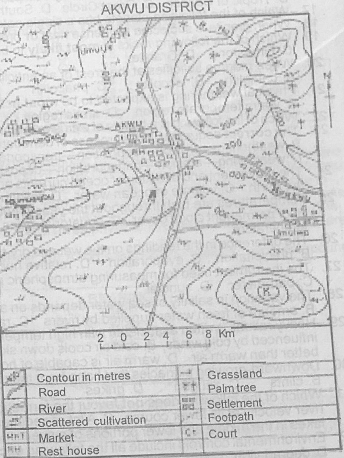
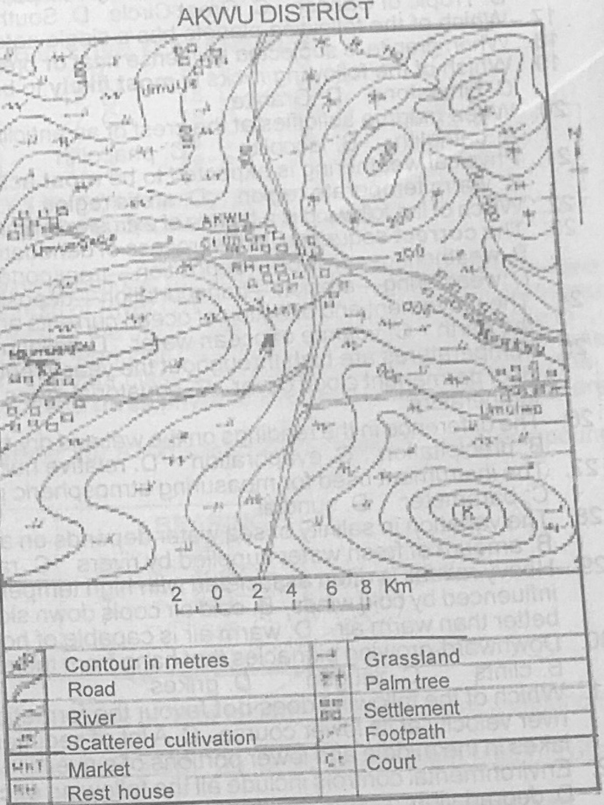
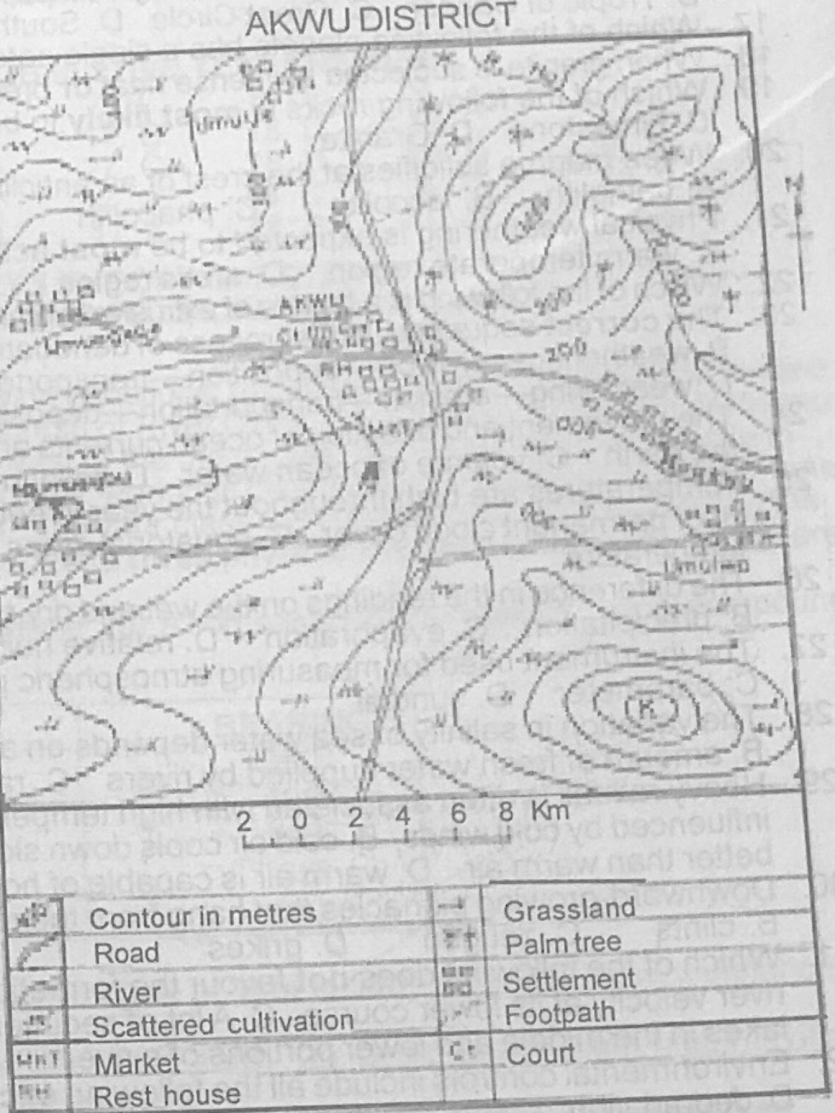
Study the map of AKWU DISTRICT to answer this question. If the map is enlarged to twice its size, the new scale will be

Diagram for this question
  1. A.1 : 100,000
  2. B.1 : 200,000
  3. C.1 : 300,000
  4. D.1 : 400,000
Show the answer and explanation

Answer: A (1 : 100,000)

Explanation

Enlarging a map twice halves the denominator of the RF: 200,000 ÷ 2 = 100,000.

Open this question

Question 3

Map Scale, Distance and Direction

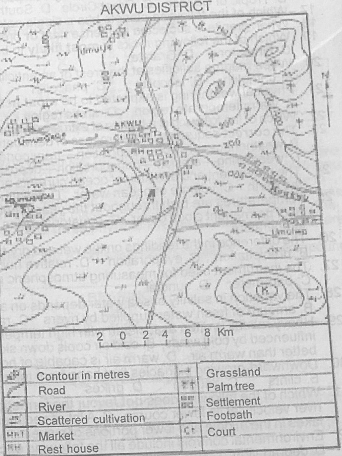
Study the map of AKWU DISTRICT to answer this question. The total area covered by the map is

Diagram for this question
  1. A.1010km²
  2. B.1020km²
  3. C.1045km²
  4. D.1055km²
Show the answer and explanation

Answer: B (1020km²)

Explanation

Use the linear scale to measure the length and width of the map frame in kilometres (about 31 km by 33 km) and multiply them.

Open this question

Question 4

Relief and Map Interpretation

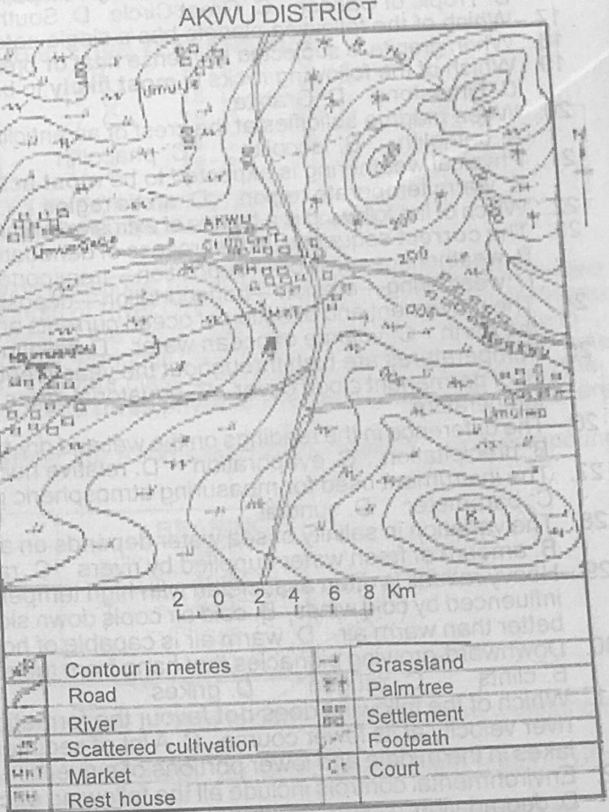
Study the map of AKWU DISTRICT to answer this question. The feature marked K in the south eastern part of the map is a

Diagram for this question
  1. A.ridge
  2. B.cuesta
  3. C.conical hill
  4. D.dissected hill
Show the answer and explanation

Answer: C (conical hill)

Explanation

K is surrounded by roughly circular, closed contours that get smaller towards the top: a conical hill.

Open this question

Question 5

Relief and Map Interpretation

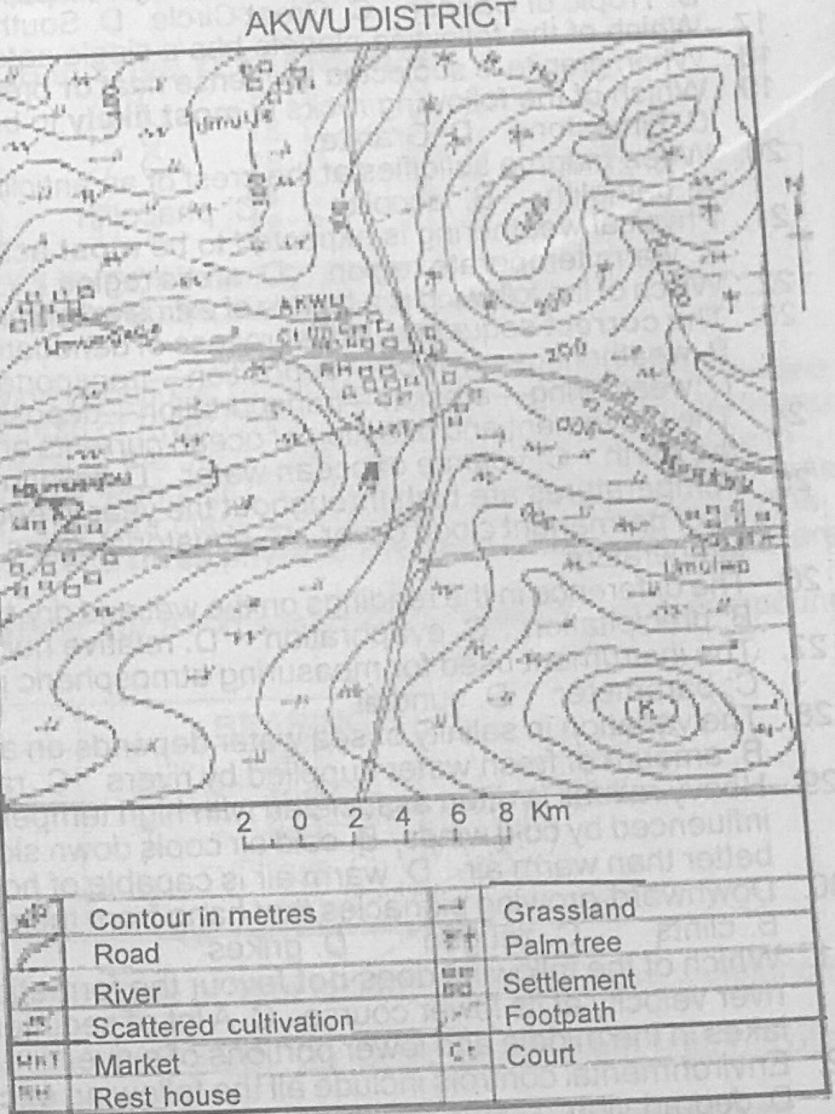
Study the map of AKWU DISTRICT to answer this question. Which of the following is a likely economic activity in the mapped area?

Diagram for this question
  1. A.Lumbering
  2. B.Animal rearing
  3. C.Mining
  4. D.Wood carving
Show the answer and explanation

Answer: B (Animal rearing)

Explanation

Grassland symbols cover much of the map and there are no forest or mine symbols, so animal rearing is likely.

Open this question

Question 7

Relief and Map Interpretation

Study the map of AKWU DISTRICT to answer this question. Akwu is an example of a

Diagram for this question
  1. A.linear settlement
  2. B.nodal settlement
  3. C.scattered settlement
  4. D.hill-slope settlement
Show the answer and explanation

Answer: B (nodal settlement)

Explanation

Akwu stands where several roads meet, which makes it a nodal settlement.

Open this question

Question 10

Relief and Map Interpretation

Study the map of AKWU DISTRICT to answer this question. Akwu is likely to be the most important settlement in the area because it is

Diagram for this question
  1. A.both an administrative and a commercial centre.
  2. B.a nucleated settlement
  3. C.on a road junction
  4. D.at the centre of the map.
Show the answer and explanation

Answer: A (both an administrative and a commercial centre.)

Explanation

Akwu has a court (administration) and a market (commerce), which other settlements lack.

Open this question

Question 11

Statistical Maps and Diagrams

Temperature statistics can best be represented with

  1. A.line graphs
  2. B.pie graphs
  3. C.dot maps
  4. D.density maps.
Show the answer and explanation

Answer: A (line graphs)

Explanation

Temperature changes continuously through the year, so a line graph shows its rise and fall best.

Open this question

Question 12

The Earth and Solar System

The earth's movement from west to east on its own axis is known as

  1. A.rotation
  2. B.revolution
  3. C.friction
  4. D.gravitation.
Show the answer and explanation

Answer: A (rotation)

Explanation

Spinning on its own axis is rotation; moving round the sun is revolution.

Open this question

Question 13

The Earth and Solar System

The tilting of the earth's axis and the revolution of the earth cause

  1. A.differences in the length of day and night
  2. B.differences in time between places on different longitudes
  3. C.the deflection of ocean currents and winds.
  4. D.low tides and high tides.
Show the answer and explanation

Answer: A (differences in the length of day and night)

Explanation

Because the axis is tilted as the earth orbits the sun, the length of day and night (and the seasons) changes through the year.

Open this question

Question 14

Latitude, Longitude and Time

Lines of longitude can best be described as

  1. A.parallel lines that show the angular distance of a place north or south of the equator.
  2. B.imaginary lines on the earth's surface running from the north pole to the south pole and at right angles to the parallels.
  3. C.semi-circles on the globe.
  4. D.the distance of a place east or west of the prime meridian.
Show the answer and explanation

Answer: B (imaginary lines on the earth's surface running from the north pole to the south pole and at right angles to the parallels.)

Explanation

Meridians (lines of longitude) are imaginary lines joining the two poles and crossing the parallels at right angles.

Open this question

Question 15

Latitude, Longitude and Time

If it is 3pm GMT on Sunday at Accra, what will be the local time in town X located on longitude 165°E?

  1. A.2.00am on Saturday
  2. B.10.00pm of Sunday
  3. C.11.00pm on Sunday
  4. D.2.00am on Monday
Show the answer and explanation

Answer: D (2.00am on Monday)

Explanation

165° × 4 minutes = 660 minutes = 11 hours ahead of GMT (east gains time): 3 pm Sunday + 11 h = 2 am Monday.

Open this question

Question 16

Latitude, Longitude and Time

The shortest flying route between any two points on the earth's surface lies along the

  1. A.Tropic of Capricorn
  2. B.Tropic of Cancer
  3. C.Great Circle
  4. D.South Pole
Show the answer and explanation

Answer: C (Great Circle)

Explanation

The shortest route between two points on a sphere is an arc of a great circle.

Open this question

Question 17

The Earth and Solar System

Which of the following planets has a single satellite?

  1. A.Jupiter
  2. B.Saturn
  3. C.Uranus
  4. D.Earth
Show the answer and explanation

Answer: D (Earth)

Explanation

The earth has only one natural satellite, the moon; the others have many.

Open this question

Question 18

Rocks

When granite is subjected to intense heat or pressure, it forms

  1. A.quartzite
  2. B.slate
  3. C.graphite
  4. D.gneiss
Show the answer and explanation

Answer: D (gneiss)

Explanation

Metamorphism of granite produces gneiss; quartzite comes from sandstone, slate from shale.

Open this question

Question 19

Rocks

Which of the following rocks is most likely to be weathered by the process of solution?

  1. A.Slate
  2. B.Graphite
  3. C.Limestone
  4. D.Granite
Show the answer and explanation

Answer: C (Limestone)

Explanation

Limestone (calcium carbonate) dissolves in rainwater containing carbon dioxide.

Open this question

Question 20

Earth Movements and Vulcanicity

When magma solidifies at the crest of an anticline or at the bottom of a syncline, the feature formed is called

  1. A.batholith
  2. B.laccolith
  3. C.phacolith
  4. D.lapolith
Show the answer and explanation

Answer: C (phacolith)

Explanation

A lens-shaped intrusion in the crest of an anticline or trough of a syncline is a phacolith.

Open this question

Question 21

Weathering, Erosion and Mass Movement

Physical weathering is expected to be most active in the

  1. A.tropical continental region
  2. B.hot desert region
  3. C.warm temperate region
  4. D.arctic region
Show the answer and explanation

Answer: B (hot desert region)

Explanation

Hot deserts have a very large daily range of temperature and little moisture, so rocks break up mainly by expansion and contraction.

Open this question

Question 22

Earth Movements and Vulcanicity

Which of the following is a feature of extrusive vulcanicity?

  1. A.Lopolith
  2. B.Sill
  3. C.Composite cone
  4. D.Batholith
Show the answer and explanation

Answer: C (Composite cone)

Explanation

A composite cone is built on the surface from layers of lava and ash; the others form underground.

Open this question

Question 23

Weathering, Erosion and Mass Movement

The correct sequence in the process of denudation is

  1. A.weathering—transportation—erosion—deposition
  2. B.weathering—erosion—deposition—transportation
  3. C.erosion—weathering—transportation—deposition
  4. D.weathering—erosion—transportation—deposition.
Show the answer and explanation

Answer: D (weathering—erosion—transportation—deposition.)

Explanation

Rock is first broken down (weathering), then worn and removed (erosion), carried away (transportation) and finally laid down (deposition).

Open this question

Question 24

Oceans and Lakes

The movement and direction of ocean currents are affected by the

  1. A.rate of evaporation of sea water
  2. B.rotation of the earth
  3. C.volume of ocean water
  4. D.relief of the ocean bed
Show the answer and explanation

Answer: B (rotation of the earth)

Explanation

The earth's rotation deflects currents to the right in the northern hemisphere and to the left in the southern (Coriolis force).

Open this question

Question 25

Climate

Temperatures are high throughout the year in equatorial areas mainly because

  1. A.insolation is constantly high
  2. B.of permanent cloud cover
  3. C.equatorial areas are influenced by currents.
  4. D.there are few highlands to reduce temperature.
Show the answer and explanation

Answer: A (insolation is constantly high)

Explanation

The midday sun is almost overhead all year at the equator, so the heat received is always high.

Open this question

Question 26

Weather

The difference in the readings on the wet and dry-bulb thermometers is used to determine

  1. A.atmospheric pressure
  2. B.precipitation
  3. C.evaporation
  4. D.relative humidity
Show the answer and explanation

Answer: D (relative humidity)

Explanation

A hygrometer (wet- and dry-bulb thermometers) gives relative humidity from the difference between the two readings.

Open this question

Question 27

Weather

The instrument used for measuring atmospheric pressure is known as

  1. A.rain guage
  2. B.thermometer
  3. C.barometer
  4. D.sundial
Show the answer and explanation

Answer: C (barometer)

Explanation

A barometer measures air pressure.

Open this question

Question 28

Oceans and Lakes

The variation in salinity of sea water depends on all the following factors except the

  1. A.rate of evaporation
  2. B.amount of fresh water supplied by rivers
  3. C.rate of water mixing by ocean currents.
  4. D.slope of the land.
Show the answer and explanation

Answer: D (slope of the land.)

Explanation

Salinity is controlled by evaporation, fresh-water inflow and mixing; the slope of the land has no effect.

Open this question

Question 29

Weather

Heavy rainfall is often associated with high temperatures because

  1. A.areas of high temperature are always influenced by cold winds
  2. B.cold air cools down slowly to make condensation possible.
  3. C.cold air retains moisture better than warm air.
  4. D.warm air is capable of holding more moisture than cold air.
Show the answer and explanation

Answer: D (warm air is capable of holding more moisture than cold air.)

Explanation

Warm air can hold much more water vapour, so when it rises and cools it gives heavy rain.

Open this question

Question 30

Underground Water and Karst

Downward-growing pinnacles that hang from the roofs of caves in limestone regions are called

  1. A.stalactites
  2. B.clints
  3. C.zeugen
  4. D.grikes
Show the answer and explanation

Answer: A (stalactites)

Explanation

Stalactites hang down from the roof; stalagmites grow up from the floor.

Open this question

Question 31

Rivers and River Landforms

Which of the following does not favour the formation of deltas?

  1. A.A long upper course of a river
  2. B.A reduction in river velocity at its lower course
  3. C.A lot of sediments in the lower course of a river
  4. D.The existence of large lakes in the middle and lower portions of a river.
Show the answer and explanation

Answer: D (The existence of large lakes in the middle and lower portions of a river.)

Explanation

Large lakes along the river trap its sediment, so little load reaches the mouth to build a delta.

Open this question

Question 32

Environmental Hazards and Conservation

Environmental controls include all the following except

  1. A.afforestation
  2. B.preservation
  3. C.conservation
  4. D.degradation
Show the answer and explanation

Answer: D (degradation)

Explanation

Degradation is damage to the environment, not a way of controlling it.

Open this question

Question 33

Vegetation

Which of the following is not a characteristic of the rain-forest?

  1. A.There is a great variety of tree
  2. B.Many of the trees have large buttresses.
  3. C.There are many climbing plants
  4. D.Absence of epiphytes.
Show the answer and explanation

Answer: D (Absence of epiphytes.)

Explanation

Epiphytes (plants growing on other plants) are common in the rain forest, so their absence is not a feature.

Open this question

Question 34

Population

The largest concentration of human population is in

  1. A.North America
  2. B.Western Europe
  3. C.West Africa
  4. D.South East Asia
Show the answer and explanation

Answer: D (South East Asia)

Explanation

Monsoon Asia (China, India, South-East Asia) holds the largest concentration of people.

Open this question

Question 35

Population

The population of India is mainly characterised by

  1. A.low birth rate
  2. B.high death rate
  3. C.balance in age and sex structure
  4. D.high growth rate
Show the answer and explanation

Answer: D (high growth rate)

Explanation

India's birth rate is far above its death rate, giving a high rate of population growth.

Open this question

Question 36

Population

If the total population of a country is 25,000,000 and her total land area is 100,000 square kilometres, what is her population density?

  1. A.500 persons per sq. km
  2. B.450 persons per sq. km.
  3. C.350 persons per sq. km
  4. D.250 persons per sq. km.
Show the answer and explanation

Answer: D (250 persons per sq. km.)

Explanation

Density = population ÷ area = 25,000,000 ÷ 100,000 = 250 persons per sq km.

Open this question

Question 37

Settlement

Which of the following features promote the development of nucleated settlements?

  1. A.Nodal centres and natural harbours
  2. B.Narrow valleys and rugged highlands.
  3. C.Dissected plains and nodal centres
  4. D.Extensive fertile plains and steep valleys.
Show the answer and explanation

Answer: A (Nodal centres and natural harbours)

Explanation

Nodal centres and natural harbours draw people and buildings close together, so settlements there are compact (nucleated).

Open this question

Question 38

Settlement

The main difference between towns and villages is that

  1. A.towns contain more women
  2. B.villages have more occupations
  3. C.towns perform more tertiary functions
  4. D.villages have more food.
Show the answer and explanation

Answer: C (towns perform more tertiary functions)

Explanation

Towns provide many services (trade, banking, administration), while villages are mainly engaged in primary activities like farming.

Open this question

Question 39

Manufacturing Industry

Most of the industries located in rural areas are

  1. A.market-oriented
  2. B.high energy-oriented
  3. C.raw material-oriented
  4. D.transport-oriented.
Show the answer and explanation

Answer: C (raw material-oriented)

Explanation

Rural industries (e.g. sawmills, oil mills, cement works) are sited near the bulky raw materials they process.

Open this question

Question 40

Manufacturing Industry

Which of the following is a service industry?

  1. A.Leather processing
  2. B.Farming
  3. C.Petroleum refining
  4. D.Banking
Show the answer and explanation

Answer: D (Banking)

Explanation

Banking provides a service rather than producing goods, so it is a tertiary (service) industry.

Open this question

Question 41

Agriculture, Fishing and Lumbering

One characteristic of intensive farming is that it is usually practised in urban centres with

  1. A.inadequate warer supply
  2. B.large population
  3. C.low population
  4. D.mineral deposits
Show the answer and explanation

Answer: B (large population)

Explanation

Intensive farming uses small plots heavily, which happens where many people press on limited land.

Open this question

Question 42

Mining and Energy

The most important method of mining tin in Nigeria is the

  1. A.shaft
  2. B.open cast
  3. C.drilling
  4. D.adit
Show the answer and explanation

Answer: B (open cast)

Explanation

Tin ore on the Jos Plateau lies near the surface in alluvial deposits, so it is mined by open cast (and paddock) methods.

Open this question

Question 43

Transport, Trade and Tourism

Trade among West African countries is low mainly because they

  1. A.are generally poor
  2. B.have different currencies
  3. C.produce different goods
  4. D.produce similar goods.
Show the answer and explanation

Answer: D (produce similar goods.)

Explanation

Most West African countries export the same primary products (cocoa, groundnuts, palm oil), so they have little to sell to one another.

Open this question

Question 44

Mining and Energy

In which of the following order is copper produced?

  1. A.Blasting-grinding-crushing-floting-smelting
  2. B.Blasting-crushing-floting-grinding-smelting
  3. C.Blasting-crushing-grinding-floting-smelting
  4. D.Crushing-blasting-grinding-smelting-floting
Show the answer and explanation

Answer: C (Blasting-crushing-grinding-floting-smelting)

Explanation

The ore is blasted out, crushed, ground to powder, concentrated by flotation and then smelted.

Open this question

Question 45

Vegetation

The major difference between the tropical rain-forest and the savanna is that savanna vegetation

  1. A.and the rain-forest never occur on the same continent
  2. B.is natural while the rain-forest is derived
  3. C.grows in layers while the rain-forest does not
  4. D.has less species of plants while the rain-forest has diverse species of plants.
Show the answer and explanation

Answer: D (has less species of plants while the rain-forest has diverse species of plants.)

Explanation

The rain forest has a huge variety of tree species; savanna is mainly grass with fewer kinds of trees.

Open this question

Question 46

Vegetation

The vegetation type characterised by short grasses and stunted trees is the

  1. A.warm temperate grassland
  2. B.Sudan savanna
  3. C.Guinea savanna
  4. D.cool temperate grassland
Show the answer and explanation

Answer: B (Sudan savanna)

Explanation

Sudan savanna has short grasses and scattered, stunted, drought-resistant trees; Guinea savanna has taller grass and trees.

Open this question

Question 47

Environmental Hazards and Conservation

Which of the following is not a cause of desertification in West Africa?

  1. A.Constant high temperature
  2. B.Deforestation
  3. C.Overcultivation
  4. D.Overgrazing
Show the answer and explanation

Answer: A (Constant high temperature)

Explanation

Desertification is driven by human misuse of land such as cutting trees, overcultivation and overgrazing; high temperature alone does not cause it.

Open this question

Question 48

The Ecosystem

The most critical element in an ecosystem is the

  1. A.growth per day
  2. B.energy flow within the system
  3. C.number of organisms in the system
  4. D.location of the system
Show the answer and explanation

Answer: B (energy flow within the system)

Explanation

All life in an ecosystem depends on energy flowing from the sun through producers to consumers.

Open this question

Question 49

Geography of Africa

The most important cash crop grown in the Nile Basin is

  1. A.barley
  2. B.cotton
  3. C.groundnut
  4. D.sugar cane
Show the answer and explanation

Answer: B (cotton)

Explanation

Long-staple cotton grown under irrigation (e.g. Gezira, Egypt) is the main cash crop of the Nile Basin.

Open this question

Question 50

Geography of Africa

The leading producer of diamond in Africa is

  1. A.Zaire (Democratic Republic of Congo)
  2. B.Nigeria
  3. C.Tanzania
  4. D.The Gambia
Show the answer and explanation

Answer: A (Zaire (Democratic Republic of Congo))

Explanation

The DR Congo (Zaire) produces the largest quantity of diamonds (mostly industrial) among the options.

Open this question

Theory question 101

Population

Country X has five states, A, B, C, D and E with population statistics and land area as stated in the table below.
Table I Population/Land area statistics for the five states in Country X:
State A: total population 5.4 million, total land area 120,000 km²
State B: 4.2 million, 85,000 km²
State C: 6.5 million, 135,000 km²
State D: 3.2 million, 98,000 km²
State E: 7.4 million, 140,000 km²
Total: ?, ?
Use the table above to: (a) Calculate the (i) total population (ii) total land area (iii) population density. (b) Explain four factors responsible for the distribution of world population. (c) Highlight three factors that cause increase in world population.

Show the model answer
Model answer

(a)(i) 5.4 + 4.2 + 6.5 + 3.2 + 7.4 = 26.7 million (26,700,000).
(ii) 120,000 + 85,000 + 135,000 + 98,000 + 140,000 = 578,000 km².
(iii) 26,700,000 ÷ 578,000 = about 46 persons per km².
(b) Relief: lowlands and plains are densely settled, rugged mountains sparsely; climate: moderate climates attract people while very hot, cold or dry areas repel them; soils: fertile soils (river valleys, volcanic soils) support dense farming populations; water supply; minerals and industry create jobs and attract people; accessibility and transport; pests and diseases (tsetse fly) repel people; political stability and history.
(c) High birth rate; falling death rate through better medical care and sanitation; improved food supply; early marriage and religious/cultural attitudes against birth control; immigration.

Explanation

Show the working for each calculation and give the unit.

Open this question

Theory question 102

Manufacturing Industry

(a) With specific examples, explain the terms: (i) light industry (ii) heavy industry. (b) Highlight four factors that limit industrial development in tropical Africa.

Show the model answer
Model answer

(a)(i) Light industry uses small quantities of light raw materials and produces light consumer goods, needs little capital and can be sited near markets, e.g. textiles, bakery, soft drinks, cosmetics, plastics.
(ii) Heavy industry uses large quantities of bulky raw materials and heavy machinery, needs huge capital and produces heavy goods often used by other industries, e.g. iron and steel (Ajaokuta), shipbuilding, petroleum refining, cement.
(b) Shortage of capital; inadequate and erratic power supply; poor transport and communication; shortage of skilled labour and technology; small home market due to low incomes; political instability; competition from imported goods; corruption and poor management; inadequate raw materials processing.

Explanation

Give a named example for each term.

Open this question

Theory question 103

Transport, Trade and Tourism

(a) Give any three reasons each for the (i) high volume of trade between Nigeria and the U.S.A. (ii) low volume of trade between Nigeria and Ghana. (b) Suggest any four ways of improving trade between Nigeria and other West African countries.

Show the model answer
Model answer

(a)(i) Nigeria and the USA produce different goods (complementary): Nigeria sells crude oil and cocoa, the USA sells machinery and manufactured goods; the USA is a large rich market; good shipping and air links; long-standing trade agreements and investment by US oil companies; Nigeria's demand for American technology.
(ii) Nigeria and Ghana produce similar goods (cocoa, palm produce, timber); different currencies and exchange problems; poor road and rail links; trade barriers, border closures and tariffs; colonial ties directed trade to Europe; political disagreements; smuggling.
(b) Remove tariffs and border barriers (ECOWAS free trade); build roads and railways linking the countries; common currency or easy exchange; diversify production so countries have different goods to sell; stable governments and good relations; trade fairs and information.

Explanation

Contrast complementary production (high trade) with similar production (low trade).

Open this question

Theory question 104

Nigeria: People and Economy

(a) On an outline map of Nigeria, locate and name one area noted for each of the following: (i) tin mining; (ii) limestone mining; (iii) thermal power station; (iv) oil refinery; (v) hydro-electric power station. (b) Describe the method of mining tin in Nigeria. (c) State four ways in which minerals are of economic importance to Nigeria.

Show the model answer
Model answer

(a) Tin: Jos Plateau (Jos, Bukuru); limestone: Ewekoro, Nkalagu, Sokoto, Ukpilla, Calabar; thermal power: Egbin, Afam, Sapele, Ughelli, Ijora; oil refinery: Port Harcourt (Alesa-Eleme), Warri, Kaduna; HEP: Kainji, Jebba, Shiroro.
(b) Tin ore (cassiterite) occurs in alluvial deposits near the surface; overburden removed by bulldozers or draglines (open cast/paddock method); gravel dug and washed with water jets (hydraulicking) or in sluice boxes so heavy cassiterite settles; some small-scale miners pan by hand; concentrate is dried and smelted at Jos.
(c) Foreign exchange from exports; government revenue (royalties, taxes); employment; raw materials for industries (cement, refineries); energy (coal, oil, gas); growth of towns and infrastructure.

Explanation

Place each item in its correct state on the map and add a key.

Open this question

Theory question 105

Nigeria: Physical Setting

(a) On a sketch map of Nigeria, locate and name: (i) the Chad Basin and the Western Highlands; (ii) one important river in one of the regions; (iii) one important town in each region. (b) State three ways in which the relief and drainage of the Chad Basin differ from those of the Western Highlands. (c) Highlight three problems of development in the Chad Basin.

Show the model answer
Model answer

(a) Chad Basin: north-east (Borno, Yobe), around Lake Chad; rivers Komadugu-Yobe or Ngadda; town Maiduguri. Western Highlands: south-west uplands (Oyo, Osun, Ekiti, Ondo, Kwara); rivers Ogun, Osun, Oshun, Owena; town Ibadan, Ilorin, Akure, Ado-Ekiti.
(b) Chad Basin is a flat, low sedimentary plain (about 300-500 m); Western Highlands are an undulating crystalline upland with inselbergs (up to 600 m). Chad Basin has inland drainage into Lake Chad; Western Highlands drain outward to the Atlantic or the Niger. Chad Basin rivers are few and seasonal; Western Highlands have many rivers in a dendritic pattern, flowing most of the year.
(c) Low unreliable rainfall and drought; desertification and shrinking of Lake Chad; poor soils and sand dunes; long distance from the coast and poor transport; insecurity; shortage of water for industry; few industries and low investment.

Explanation

Contrast the two regions point by point (height, rock, drainage pattern).

Open this question

Theory question 106

Nigeria: Physical Setting

(a) On an outline map of Nigeria, show and name: (i) the mangrove swamp forest (ii) the Sahel savanna (iii) the Guinea savanna (iv) one major town in 6(a)(i) and 6(a)(iii) above. (b) Highlight three main characteristics of the Guinea Savanna vegetation. (c) Outline four ways in which the mangrove swamp forest is of economic importance.

Show the model answer
Model answer

(a) Mangrove swamp: coastal strip of the Niger Delta and Lagos/Calabar lagoons (town Port Harcourt, Warri, Calabar); Sahel savanna: extreme north-east and north-west (around Lake Chad); Guinea savanna: middle belt (towns Ilorin, Makurdi, Minna, Abuja, Lokoja).
(b) Tall grasses (1.5-3 m) such as elephant grass; scattered deciduous trees (shea butter, locust bean, oil palm along rivers) that shed leaves in the dry season; gallery forests along rivers; trees have thick bark and long roots to resist fire and drought; grass dries and is burnt in the dry season.
(c) Wood for fuel and charcoal; poles for building; tannin from bark for dyeing and tanning; medicinal herbs; fishing and shellfish (oysters, crabs) among the roots; ropes and raffia; protection of the coast from erosion; tourism.

Explanation

Shade each vegetation belt in the correct latitude and add a key.

Open this question

Theory question 107

West Africa and ECOWAS

(a) Draw an outline map of West Africa, and on it, locate and name (outside your country): (i) two areas with a population density of over 500 persons per square kilometre (ii) two areas with a population density of less than 50 persons per square kilometre (iii) one important town in one of the areas shown in 7(a)(i) above. (b) Highlight three factors that favour the high population density in one of the areas shown on your map. (c) In what four ways is high population concentration a problem to the area described in 7(b) above?

Show the model answer
Model answer

(a) Dense areas: coastal Ghana around Accra, Freetown peninsula, Dakar area, Abidjan area, Lomé, Cotonou; sparse areas: Sahel/Sahara of Mali, Niger and Mauritania (e.g. around Kayes, Bamako hinterland, northern Niger); town e.g. Accra or Dakar.
(b) Port and capital functions with jobs; industries; fertile soils and favourable climate; good transport and nodal location; social amenities (schools, hospitals); commercial activities; political stability.
(c) Overcrowding and slums; housing shortage and high rents; unemployment and crime; traffic congestion; pollution and poor sanitation; spread of diseases; pressure on water, power and other services; high cost of living.

Explanation

Use a clear key for the two density classes.

Open this question

Theory question 108

Geography of Africa

(a) On a sketch map of Africa, locate and name: (i) two fold mountain areas (ii) two important rivers north of the equator (iii) two ocean currents: one warm; one cold (iv) the Tropic of Cancer and Capricorn. (b) Explain how one of the ocean currents in 8(a)(iii) above affect the climate and vegetation of the adjacent coastlands.

Show the model answer
Model answer

(a) Fold mountains: Atlas (north-west), Cape Ranges (south); rivers north of equator: Niger, Nile, Senegal, Volta, Benue; warm current: Guinea current or Mozambique/Agulhas current; cold current: Benguela (south-west) or Canaries (north-west); Tropic of Cancer 23½°N across the Sahara, Tropic of Capricorn 23½°S across southern Africa.
(b) Cold current (e.g. Benguela): cools the air above it so onshore winds are cool and dry; air is stable so little rain falls; fog and mist form along the coast; low temperatures and low rainfall give desert or semi-desert (Namib) with scanty, drought-resistant vegetation.
Warm current (e.g. Mozambique/Guinea): warms the air and adds moisture; onshore winds bring heavy rain; raises coastal temperatures; supports dense forest vegetation.

Explanation

Show warm currents and cold currents with different arrows in the key.

Open this question

Theory question 109

Agriculture, Fishing and Lumbering

Write a geographical account of irrigation agriculture in the Niger Basin under the following headings: (a) Areas (b) Methods (c) Crops (d) Problems (e) Solutions

Show the model answer
Model answer

(a) Inland delta of the Niger in Mali (Office du Niger, Ségou-Mopti); Sokoto-Rima valley; Bacita and Jebba (sugarcane); Kano river project; Hadejia valley; Niger valley in Niger Republic.
(b) Basin or flood irrigation using flood water; perennial irrigation from dams and barrages with canals; pump irrigation from rivers; shaduf and hand watering; sprinkler and drip methods.
(c) Rice, cotton, sugarcane, wheat, millet, sorghum, onions, vegetables, groundnuts, maize.
(d) High cost of dams and canals; silting of reservoirs; soil salinity from evaporation; seasonal flow of rivers; flooding of farms; water weeds; water-borne diseases (bilharzia, malaria); displacement of people.
(e) Better irrigation methods and drainage; dredging of channels; leaching and soil treatment against salinity; storing flood water; clearing weeds; medical care; resettlement and compensation; government funding and modern technology.

Explanation

Write short notes under each of the five headings.

Open this question

Theory question 202

Surveying

(a) Describe, with the aid of a suitable diagram, an open traverse. (b) A compass traverse round a school compound produced the following field record:
Line AB: length 370 m, bearing 260°
Line BC: length 450 m, bearing 198°
Line CD: length 265 m, bearing 110°
Line DE: length 560 m, bearing 35°
Line EA: length 140 m, bearing 330°
Use the data above to: (i) plot the area of the compound on a scale of 1cm to 50m; (ii) find the direct distance between D and A, in metres.

Show the model answer
Model answer

(a) An open traverse is a series of connected survey lines whose lengths and bearings are measured, starting at one point and ending at another without returning to the start (e.g. along a road or river). Diagram: a zig-zag line A-B-C-D-E with lengths and bearings marked, the end not joined to the start.
(b)(i) Convert lengths at 1 cm to 50 m: AB 7.4 cm, BC 9.0 cm, CD 5.3 cm, DE 11.2 cm, EA 2.8 cm; plot each line from the previous point on its bearing with a protractor from north lines; the traverse should close (almost) at A; give a title, scale and north arrow.
(ii) Measure DA on the plot (about 12.6-12.7 cm) and multiply by 50: about 630-635 m.

Explanation

Convert each length to centimetres first, then plot bearings clockwise from north at each station.

Open this question

Theory question 203

Structure of the Earth

(a) Draw a well-labelled diagram to show the internal structure of the earth. (b) Describe the main features of any two of the parts shown in 3(a) above.

Show the model answer
Model answer

(a) Concentric diagram labelled: crust (sial over sima), Mohorovicic discontinuity, mantle, Gutenberg discontinuity, outer core (liquid), inner core (solid).
(b) Crust: outermost thin layer, 5-10 km under oceans and up to 60-70 km under continents; sial (silica and aluminium, granitic, density about 2.7) forms continents; sima (silica and magnesium, basaltic, about 3.0) forms the ocean floor; supports life and soils.
Mantle: about 2,900 km thick; dense ultrabasic rocks rich in iron and magnesium (olivine); very hot; upper part partly molten (asthenosphere) where convection currents move plates.
Core: radius about 3,400-3,500 km; made of nickel and iron (nife); very dense and hottest; outer core liquid, inner core solid; gives the earth its magnetism.

Explanation

Label the layers in order from outside in and give thickness and composition for each one you describe.

Open this question

Theory question 204

Rivers and River Landforms

Write explanatory notes on the formation of any two of the following: (a) Waterfalls (b) Deltas (c) Inselbergs

Show the model answer
Model answer

(a) Waterfalls: form where a band of hard rock lies across a river over softer rock; the soft rock downstream is eroded faster, leaving a steep step; plunge pool formed by hydraulic action and abrasion at the foot; undercutting makes the lip collapse so the fall retreats upstream (gorge); also at fault scarps, plateau edges, hanging valleys (e.g. Kainji area, Victoria Falls).
(b) Deltas: where a river enters a sea or lake its speed falls and it deposits its load; deposition faster than waves and currents can remove it; sheltered coast, gentle offshore slope and large load favour them; the river splits into distributaries through the deposits; types arcuate (Niger, Nile), bird's foot (Mississippi), estuarine.
(c) Inselbergs: isolated steep-sided hills rising abruptly from a plain in tropical/semi-arid areas; made of resistant rock (often granite); surrounding weaker rock removed by deep chemical weathering and erosion, leaving the hard core standing; examples Idanre, Olumo Rock, Zuma Rock.

Explanation

For each feature, name the process and say why that place is affected.

Open this question

Theory question 205

Weathering, Erosion and Mass Movement

(a) Define the term mass wasting. (b) Describe two types of mass wasting. (c) State three effects of mass wasting.

Show the model answer
Model answer

(a) Mass wasting (mass movement) is the movement of weathered rock and soil down a slope under the force of gravity.
(b) Soil creep: very slow, hardly noticeable movement of soil down gentle slopes, caused by wetting and drying, freezing and thawing, rain splash; shown by tilted posts, trees and walls. Landslide: sudden rapid movement of large masses of rock and soil down steep slopes, often after heavy rain or earthquakes, when the material is lubricated. Others: mudflow, earthflow, slump, solifluction, rockfall.
(c) Loss of farmland and soil fertility; destruction of buildings and displacement of settlements; blocking of roads and railways and damage to power lines; damming of rivers and flooding; loss of life.

Explanation

Define first, then give each type its speed, cause and evidence.

Open this question

Theory question 206

Vegetation

(a) Highlight the characteristics of the equatorial rain-forest. (b) Outline four ways in which climate influences the equatorial rain-forest.

Show the model answer
Model answer

(a) Tall trees (up to 60 m) with straight trunks and buttress roots; three layers of canopy; evergreen with broad leaves; great variety of species (mahogany, iroko, obeche, ebony); dense undergrowth where light reaches; climbers (lianas) and epiphytes; trees of one species scattered, not in pure stands; hardwoods.
(b) Heavy rainfall all year keeps the forest evergreen and dense; constant high temperature (about 27°C) allows continuous growth all year; high humidity favours epiphytes and luxuriant growth; heavy rain leaches soils so trees get nutrients from rapid decay of litter; strong sunlight makes trees compete upward, giving tall trees and layered canopy; no dry season so no leaf-shedding period.

Explanation

Link each climatic element (rain, heat, humidity, light) to a forest feature.

Open this question

Theory question 207

Environmental Hazards and Conservation

(a) What is environmental pollution? (b) Describe four causes of environmental pollution. (c) Outline three ways in which environmental pollution can be controlled.

Show the model answer
Model answer

(a) Environmental pollution is the release of harmful substances or energy (noise, heat) into the air, water or land so that the environment becomes unsafe or unhealthy for living things.
(b) Industrial gases and effluents from factories; exhaust fumes from vehicles and generators; oil spillage and gas flaring in oil areas; poor disposal of refuse and sewage; burning of bush, firewood and coal; overuse of fertilizers, pesticides and herbicides washed into water; noise from loudspeakers and machines; mining waste.
(c) Laws to limit emissions and dumping, with enforcement; anti-pollution devices on factories and vehicles; treating industrial waste and sewage before discharge; proper refuse collection and recycling; environmental impact assessment before projects; public education.

Explanation

Name a source and its effect for each cause.

Open this question

Theory question 208

The Ecosystem

(a) Define Ecosystem. (b) Describe four ways in which man has interferred with the ecosystem. (c) Outline three consequences of man's interference with the ecosystem.

Show the model answer
Model answer

(a) An ecosystem is a community of living things (plants, animals, micro-organisms) interacting with one another and with their non-living environment (air, water, soil, climate).
(b) Deforestation for farming, lumbering and building; bush burning; overgrazing and intensive farming with chemicals; hunting and over-fishing; mining and quarrying; industrialisation and urbanisation; dams and land reclamation; pollution of air and water.
(c) Soil erosion and loss of fertility; destruction of habitats and extinction of species; desertification; pollution and damage to health; flooding; change of local climate (global warming, ozone depletion); reduced crop yield.

Explanation

Show how each human action upsets the balance between living and non-living parts.
Open this question