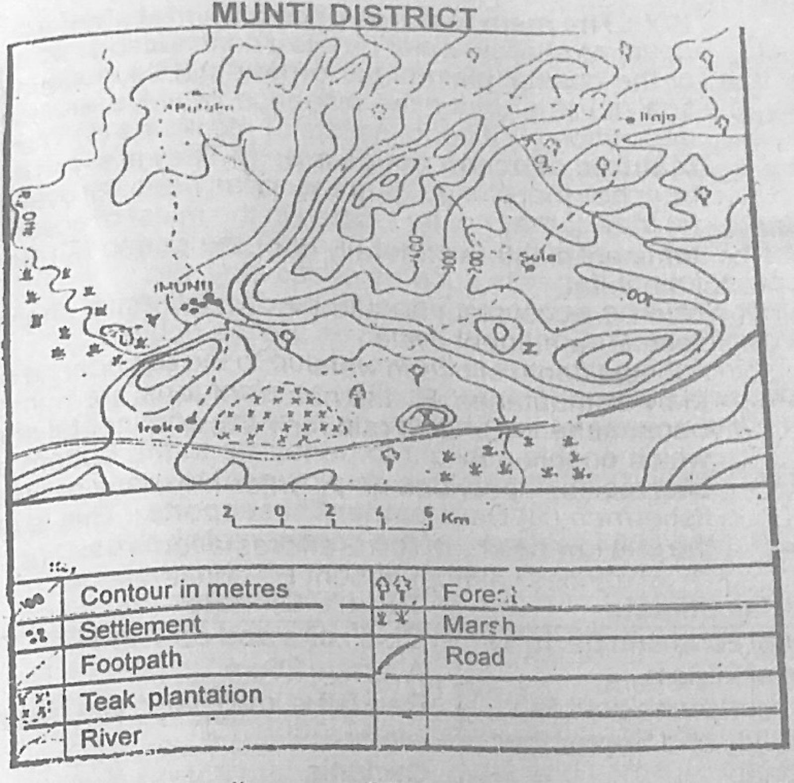
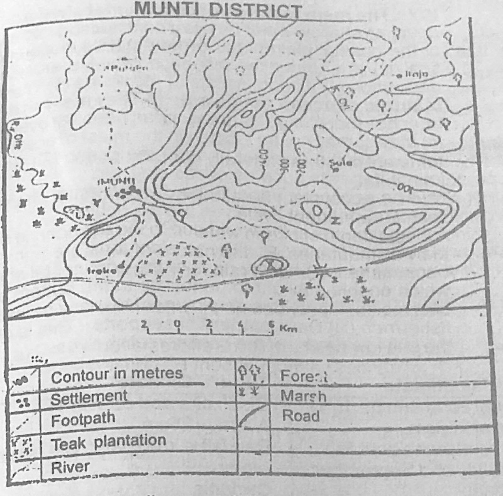
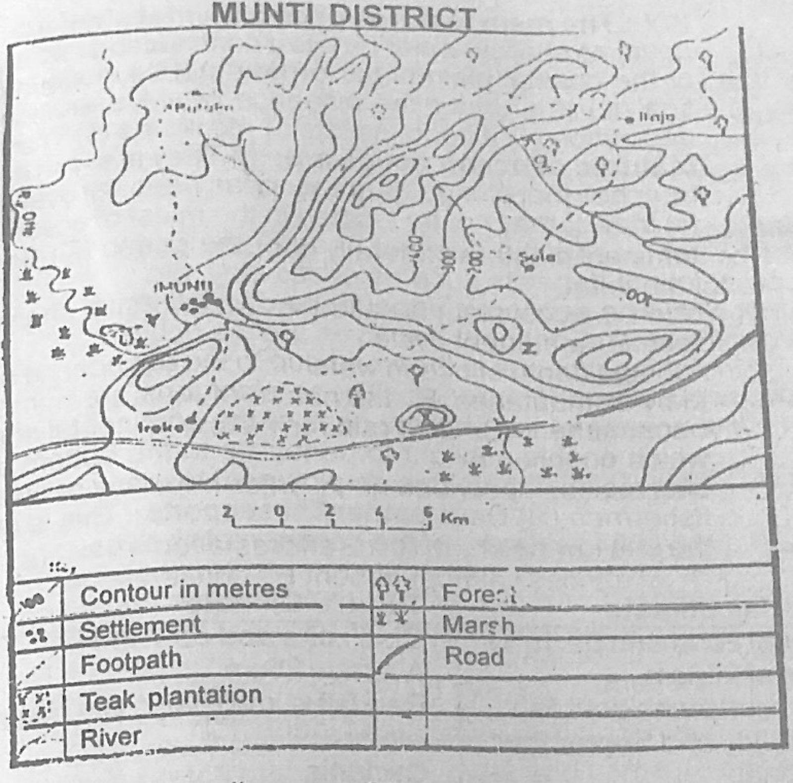
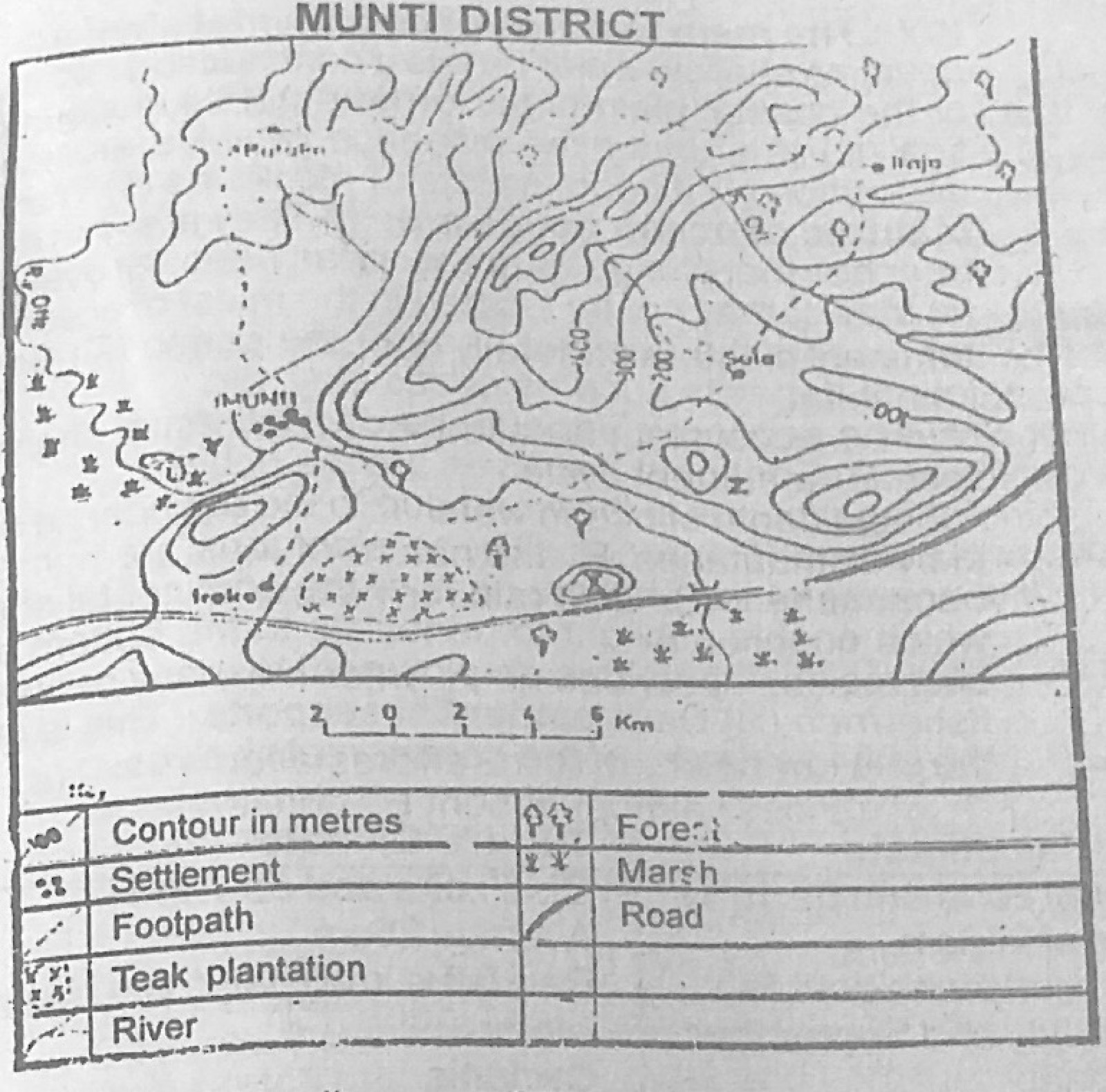
Use the map of MUNTI DISTRICT to answer the question. Which of the following crops is most likely to be grown in the flood plain of River Offe directly west of Munti?
A.Coffee
B.Cocoa
C.Wheat
D.Yam
E.Rice
Show the answer and explanation
Answer: E (Rice)
Explanation
The flood plain is marshy and floods, which suits rice.
The average afternoon temperature is over 40°C with a total rainfall of 250mm or less, occasional thuderstorm and cold nights. This description is that of the
A.western margin (Mediterranean) climate
B.tropical monsoon climate
C.hot desert climate
D.eastern margin (China type) climate
E.alphine climate
Show the answer and explanation
Answer: C (hot desert climate)
Explanation
Very hot days, cold nights and under 250 mm of rain describe the hot desert climate.
Which of the following geographical regions of Nigeria covers one-fifth of the country and has a generally flat surface dotted with granitic hills? The
A.North-Central highlands
B.Western highlands
C.North-Eastern highlands
D.Southern coastland
E.Cross River basin
Show the answer and explanation
Answer: A (North-Central highlands)
Explanation
The North-Central highlands (High Plains of Hausaland and Jos Plateau) are a wide, gently rolling surface with granite inselbergs.
The location of iron and steel industry at Ajaokuta in Nigeria is best explained by the presence of (I) iron ore at Itakpe (II) limestone at Ewekoro (III) river port at Lokoja (IV) coal at Orukpa and Okaba
A.I and II only
B.I and IV only
C.II and III only
D.II and IV only
E.III and IV only
Show the answer and explanation
Answer: B (I and IV only)
Explanation
Ajaokuta is close to iron ore at Itakpe and coal at Okaba/Orukpa; Ewekoro is far away in Ogun State.
(a) Account for the rapid growth of world population in the last two decades (b) Explain any three problems arising from this rapid growth (c) Suggest solutions to these problems
Show the model answer
Model answer
(a) Falling death rates from better medicine, vaccination and sanitation; lower infant mortality; better food supply (green revolution, mechanisation); continued high birth rates in developing countries (early marriage, large families, little birth control); longer life expectancy; peace and better living standards (b) Food shortage and malnutrition; unemployment; housing shortage and slums; pressure on schools, health and water; environmental degradation; congestion and crime (c) Family planning and education; increased food production; job creation and industrialisation; housing schemes; more social amenities; rural development to reduce migration
(a) Differentiate clearly between urban settlements and rural settlements (b) Explain four factors responsible for the increase in size of urban settlements (c) Highlight four problems associated with such growth.
Show the model answer
Model answer
(a) Urban: large population and high density; most people in secondary and tertiary jobs (industry, trade, services); many amenities; tall, closely packed buildings; mixed population. Rural: small population and low density; mainly farming, fishing, lumbering; few amenities; scattered or small clusters of houses; people of similar culture (b) Rural-urban migration for jobs; natural increase; industrialisation; administrative headquarters/capital status; commerce and transport links; social amenities and education (c) Housing shortage and slums; traffic congestion; overused amenities (water, power); unemployment and crime; pollution and waste; diseases
(a) Explain, giving examples, four ways in which physical factors may hinder the development of road transportation (b) Discuss any four factors responsible for the poor network of railways in tropical African countries
Show the model answer
Model answer
(a) Rugged mountains and steep slopes (e.g. Ethiopian highlands, Jos escarpment) – costly cuttings and bends; large rivers needing bridges (Niger, Zaire); swamps and creeks (Niger Delta, Sudd) – unstable ground; heavy rainfall washes roads away, causes erosion and potholes; deserts with shifting sand (Sahara); dense forest to clear (b) Very high cost of construction and maintenance; lines built in colonial times only to link mines/cash-crop areas to ports; small volume of traffic; difficult terrain; different gauges between countries; lack of skilled personnel and spare parts; competition from road transport; poor management
(a) Describe three ways in which light industries differ from heavy industries (b) Give four reasons why light industries are more prevalent than heavy industries in tropical Africa.
Show the model answer
Model answer
(a) Light industries make small, light consumer goods (shoes, soap, drinks), heavy industries make bulky producer goods (steel, machines, ships); light need little capital and space, heavy need huge capital and large sites; light use small amounts of raw materials and power, heavy use great quantities; light employ many women, heavy mainly men; light located near markets, heavy near raw materials/ports (b) Shortage of capital for heavy industry; lack of technology and skilled labour; small local market for heavy goods but large demand for consumer goods; raw materials for light industries are available locally (cotton, cocoa, palm oil); quick returns on investment; inadequate power supply; government import-substitution policies
(a) Give four reasons why countries engage in world trade (b) How have these reasons affected the volume of trade between Nigeria and her neighbouring countries? (c)(i) Name any two sea routes through which Nigeria trades with the outside world (ii) Indicate one commodity that Nigeria exports through each route
Show the model answer
Model answer
(a) Uneven distribution of resources; differences in climate and products; differences in technology and industrial development; specialisation and surplus production; to earn foreign exchange; demand for goods not produced at home (b) Nigeria and her neighbours produce similar primary goods (cocoa, groundnut, palm produce), so there is little to exchange; none has much manufacturing to offer; so official trade is small, though smuggling exists; poor road links and different currencies (CFA franc vs naira) reduce it further (c)(i) e.g. South Atlantic route (to Europe), North Atlantic/Trans-Atlantic route (to USA), Cape route (to Asia) (ii) crude oil to the USA through the North Atlantic route; cocoa to Europe through the South Atlantic route
(a) On an outline map of Nigeria, locate and name (i) one inland drainage basin (ii) three rivers that flow into the basin (iii) the Bight of Benin and Bight of Bonny (iv) the Idanre Hill, Oban Hills and Biu plateau (b) Account for the shallowness of the rivers and the lake of the inland drainage basin (c) Describe any four benefits of the lake.
Show the model answer
Model answer
(a) Chad basin; rivers Komadugu-Yobe, Hadejia, Jama'are (also El Beid, Ngadda); Bight of Benin (west coast) and Bight of Bonny (east coast); Idanre Hill (Ondo), Oban Hills (Cross River), Biu Plateau (Borno) (b) Low and seasonal rainfall; very high evaporation and temperatures; flat, low gradient land; heavy silting with sand; seepage into porous sediments; dams and irrigation upstream take water; long dry season (c) Fishing; irrigation farming around the lake (South Chad Irrigation Project); water for people and livestock; transport across the lake; fertile lake-bed farmland when the water recedes; tourism
(a) On an outline map of Nigeria, show the main soil zones (b) Name any one crop that is grown in each of the zones shown on your map (c) Describe the soil characteristics that have favoured the cultivation of the type of crops in each zone.
Show the model answer
Model answer
(a) Map with key, e.g. coastal/swamp and hydromorphic soils (Niger Delta and coast); forest (ferrallitic) soils of the south; ferruginous tropical soils of the savanna (middle belt and north); sandy/arid brown soils of the far north; alluvial/fadama soils along major rivers (b) e.g. swamp soils – rice; forest soils – cocoa/oil palm/yam; ferruginous soils – yam, sorghum, cotton; sandy northern soils – groundnut, millet; fadama alluvium – rice, onions, wheat (c) Forest soils: deep, rich in humus, well drained loams – good for tree crops and yams; ferruginous soils: moderately fertile, well drained, sandy loam – grains, cotton, yam; sandy soils: light, loose, well drained – groundnuts develop pods easily, millet; hydromorphic/alluvial: waterlogged, fertile silt – rice
(a) Distinguish between internal trade and international trade (b) Name four commodities of internal trade in Nigeria two orginating from the north and two from the south (c) Identify the factors that promote trade between the northern and southern parts of Nigeria (d) What are the limitations to internal trade in Nigeria?
Show the model answer
Model answer
(a) Internal trade: exchange of goods and services within the boundaries of one country using its own currency; international trade: exchange between different countries, involving foreign currencies, customs duties and documents (b) North: cattle, onions, beans, groundnut, grains, tomatoes; south: kola nuts, yam, cassava/garri, palm oil, fish, manufactured goods (c) Different climates and vegetation produce different goods; good road and rail links (Lagos-Kano, Port Harcourt-Maiduguri); common currency and no tariffs; large population and demand; traders' networks and markets; national unity (d) Poor roads and high transport costs; perishability and lack of storage; extortion at checkpoints; insecurity; low purchasing power; seasonal supply
(a) Explain any two of the following methods of farming as adopted in Nigeria (i) Mixed farming (ii) Intensive farming (iii) Plantation agriculture (b) State three problems facing agriculture in Nigeria (c) In what ways are these problems being solved?
Show the model answer
Model answer
(a) Any two: mixed farming – crops and livestock on the same farm; animals give manure and draught power, crop residues feed animals (e.g. in the north with Fulani/settled farmers); intensive farming – much labour, manure and capital on small plots, continuous cropping, irrigation (Kano close-settled zone, Igboland compound farms); plantation – large estates of one cash crop (rubber, oil palm, cocoa), scientific methods, large capital, hired labour, processing on the estate (e.g. at Sapele, Calabar) (b) Small farms and land tenure; simple tools; poor soils, erosion and drought; pests and diseases; lack of credit; poor storage and transport; ageing farmers and rural-urban drift; low prices (c) Agricultural credit banks and loans; supply of fertilisers, improved seeds and tractors; ADPs and extension services; irrigation and River Basin Authorities; research institutes; better roads; guaranteed prices; land reforms (Land Use Decree)
(a) Outline any four factors that have encouraged the concentration of industries in the Lagos area (b) Highlight the significance of the concentration to the inhabitants of the area.
Show the model answer
Model answer
(a) Port of Apapa for importing raw materials and machinery and exporting goods; large market (biggest city); abundant labour; capital, banks and commercial services; power, water and good road, rail and air links; former federal capital and government incentives; industrial estates (Ikeja, Apapa) (b) Jobs and incomes; availability of manufactured goods; better social amenities and infrastructure; growth of commerce and services; but also overcrowding, slums, traffic congestion, pollution and crime
(a) On a sketch map of West Africa, show and name (i) the home areas of the Ashanti, the Wolof and the Mandingo (ii) two areas with a population density of over 100 persons per km² (iii) two areas with a population density of less than 5 persons per km² (b) Explain how the variation in population density in West Africa has been aided by the following: (i) Historical factors (ii) Agriculture (iii) Mining (iv) Industrialization
Show the model answer
Model answer
(a) Ashanti – central Ghana (Kumasi); Wolof – western Senegal/Gambia; Mandingo – Mali/upper Niger and Gambia-Guinea; dense (>100/km²): e.g. SE Nigeria (Igboland), SW Nigeria (Ibadan-Lagos), Kano area, Accra-Kumasi area of Ghana; sparse (<5/km²): Sahara of Mauritania, Mali and Niger; middle belt in places (b)(i) Historical: old kingdoms (Hausa, Yoruba, Ashanti) gave security and dense settlement; slave raiding emptied areas like the middle belt; wars pushed people to defensive hills (ii) Agriculture: fertile soils and good rainfall (cocoa belt, Kano close-settled zone) support dense population; poor soils or tsetse areas stay sparse (iii) Mining: mines attract workers and towns (Jos tin, Enugu coal, Tarkwa gold, Sierra Leone diamonds, Port Harcourt oil) (iv) Industrialisation: industrial cities (Lagos, Kano, Abidjan, Dakar) draw migrants and become very dense
On a sketch map of Africa, show and name: (i) Cape Verde and the Cape of Good Hope (ii) the Rivers Nile, Niger and Orange (iii) the East African rift valley (iv) one fold mountain in the north and one in the south (b) In what three ways are the highlands of Africa economically important? (c) Describe three ways in which the rivers of Africa are of importance.
Show the model answer
Model answer
(a) Map: Cape Verde (westernmost point, Senegal), Cape of Good Hope (SW tip); Nile (to the Mediterranean), Niger (to the Gulf of Guinea), Orange (to the Atlantic); East African rift valley (Ethiopia to Malawi); Atlas Mountains (north), Cape Ranges/Drakensberg (south) (b) Cool climate for settlement, tea, coffee and dairying (Kenya, Ethiopia); sources of rivers and HEP; minerals (Katanga copper, Jos tin); forests and pastures; tourism (Kilimanjaro, Drakensberg); relief rainfall (c) Hydro-electric power (Kariba, Akosombo, Kainji); irrigation (Nile, Niger); navigation and transport; fishing; water supply; fertile flood plains and deltas; tourism
(a) On a sketch map of Africa, mark and name: (i) one area receiving rainfall throughout the year (ii) one area receiving rainfall in summer only (iii) one warm ocean current (indicating the direction of flow) (iv) one cold ocean current (indicating the direction of flow) (b)(i) Identify the type of nature vegetation found in each of the areas shown on your map (ii) How has rainfall accounted for the difference in vegetation in the two areas?
Show the model answer
Model answer
(a) Rain all year: Zaire basin/Guinea coast; summer rain only: savanna belt (e.g. northern Nigeria, Sudan, Zambia); warm current: Guinea current flowing east, or Mozambique/Agulhas flowing south; cold current: Canaries flowing south off NW Africa, or Benguela flowing north off SW Africa (b)(i) Tropical rain forest; tropical grassland (savanna) (ii) Rain all year keeps the forest evergreen, tall, dense and in layers with many species; rain only in summer with a long dry season gives grasses that dry up, scattered deciduous, drought- and fire-resistant trees; less total rain supports fewer trees
Give reasons for each of any three of the following: (a) the importance of fruit farming in the Mediterranean lands (b) the predominance of lumbering in the Zaire basin (c) the declining importance of bush fallowing in West Africa (d) the importance of plantation agriculture in East Africa.
Show the model answer
Model answer
Any three: (a) Mediterranean climate (hot dry sunny summers, mild wet winters) suits citrus, grapes, olives, figs; irrigation from rivers and wells; fertile valley soils; nearness to European markets; long tradition and skilled farmers; processing (wine, canning, olive oil) (b) Vast equatorial forest with valuable hardwoods; River Zaire and tributaries to float logs; port facilities (Matadi, Boma); demand at home and abroad; few alternative economic activities; foreign capital (c) Rapid population growth leaves no land for long fallows; land-use and tenure changes; permanent cash-crop farms; fertilisers allow continuous cropping; urbanisation and new roads take land; government encouragement of modern farming (d) Cool, wet highland climate and fertile volcanic soils for tea, coffee, sisal, pyrethrum; capital and expertise of settlers and companies; export earnings; employment; railways to ports (Mombasa, Dar es Salaam)
(a) Outline any three achievements of the Economic Community of West African States (ECOWAS) since its formation (b) What five problems are facing the ECOWAS in the achievement of its objectives?
Show the model answer
Model answer
(a) Protocol on free movement of persons (visa-free entry for 90 days); reduction of some tariffs/trade liberalisation; ECOWAS Fund and Bank for development projects; regional roads (Trans-West African highway) and telecommunications; ECOMOG peace-keeping (Liberia, Sierra Leone); ECOWAS travel certificate; cultural and sporting exchanges (b) Different currencies and exchange problems; language barriers (English/French/Portuguese); members producing similar goods; political instability and coups; failure to pay dues; loyalty to other groupings (e.g. CEAO) and former colonial powers; poor transport links; smuggling and border closures
(a) Explain any four ways in which lines of latitude differ from lines of longitudes (b) If the time at town A (long 75°W) is 5.00p.m on Friday, what will be the time and day at town B (long 120°E)? Show your workings clearly.
Show the model answer
Model answer
(a) Latitudes run east-west, longitudes north-south; latitudes are parallel and never meet, longitudes meet at the poles; latitudes measured 0-90° N/S of the equator, longitudes 0-180° E/W of Greenwich; lengths of parallels decrease towards the poles, all meridians are equal (half great circles); latitude used for distance and climatic zones, longitude for time (b) Longitude difference = 75 + 120 = 195°; 195 ÷ 15 = 13 hours; B is east of A, so add: 5.00 p.m. Friday + 13 h = 6.00 a.m. Saturday
Explanation
When the two places are on opposite sides of Greenwich, add the longitudes.
With the aid of suitable diagrams, describe the characteristics and mode of formation of any two of the following (a) Ox-bow lake (b) Zeugen (c) Block mountain
Show the model answer
Model answer
Any two, each with diagrams: Ox-bow lake – horseshoe-shaped lake beside a meandering river on the flood plain; formed as erosion on the outer banks narrows the neck of a meander; in flood the river cuts through the neck, deposits seal off the old loop, leaving a lake that later becomes swamp Zeugen – tabular ridges of hard rock resting on softer rock, separated by furrows, up to 30 m high, in deserts; formed where horizontal hard rock overlies soft rock: joints in the cap are widened by weathering, wind abrasion cuts down into the soft rock, leaving ridges and furrows Block mountain (horst) – steep-sided, flat-topped upland bounded by faults (e.g. Vosges, Ruwenzori); formed when tension or compression creates parallel faults and the middle block is raised or the land on either side sinks
(a) Draw a diagram of the relief of the ocean floor showing the following (i) Continental shelf (ii) Continental slope (iii) Ocean deep (b) Describe the main characteristics of any two of the features shown (c) Highlight the economic importance of continental shelves to man
Show the model answer
Model answer
(a) Cross-section from land to sea showing the gently sloping continental shelf, steep continental slope, deep-sea (abyssal) plain and a narrow ocean deep/trench, with sea level marked (b) Continental shelf: gently sloping submerged edge of the continent, to about 180 m (100 fathoms) deep, varying width; covered with sediment; sunlight reaches the bottom so plankton thrive Continental slope: steep slope from the shelf edge down to 3,000-4,000 m; cut by submarine canyons Ocean deep: long narrow trenches over 6,000 m deep, often near island arcs/fold mountains (Mariana Trench about 11,000 m) (c) Richest fishing grounds (plankton); oil and gas deposits (Niger Delta offshore, North Sea); other minerals and sand/gravel; good harbours and ports; tourism and recreation
Contrast the characteristics of the Equatorial climate with those of the Tundra climate
Show the model answer
Model answer
Location: equatorial – about 0-10° N and S (Zaire basin, Amazon, Malaysia); tundra – arctic coasts about 65-80°N (northern Canada, Siberia, Greenland coasts) Temperature: equatorial – high all year (about 27°C), annual range 2-3°C; tundra – very cold, long winters below −20°C, short cool summer under 10°C, very large range Rainfall: equatorial – heavy (over 1,500-2,000 mm), all year with two peaks, convectional with thunderstorms; tundra – very low (under 250 mm), mostly as snow, cyclonic Humidity and cloud: equatorial – high humidity and cloud; tundra – low humidity, clear cold air Day length: equatorial – about 12 hours all year; tundra – midnight sun in summer, long polar night in winter Vegetation: rain forest vs mosses, lichens and dwarf shrubs
(a) What is soil? (b) Explain the process of soil formation (c) Describe a typical soil profile
Show the model answer
Model answer
(a) The thin, loose upper layer of the earth's surface made of weathered rock particles, humus, water, air and organisms, in which plants grow (b) Weathering of parent rock (physical, chemical, biological) produces fragments; plants and animals add organic matter which decays to humus; leaching and eluviation move materials down; illuviation deposits them below; horizons develop over a long time; controlled by parent rock, climate, relief, organisms and time (c) A horizon (topsoil) – dark, humus-rich, loose, many organisms, leached; B horizon (subsoil) – zone of accumulation of clay and iron, compact, little humus; C horizon – partly weathered parent material; bedrock below; organic litter (O layer) on the surface
(a) Name four components of the ecosystem (b) How does the carbon cycle explain the inter-dependence of the components in the ecosystem?
Show the model answer
Model answer
(a) Atmosphere (air), hydrosphere (water), lithosphere (rocks and soil), biosphere (living things); or producers, consumers, decomposers and abiotic factors (b) Green plants take carbon dioxide from the air for photosynthesis to make food; animals eat plants and get carbon; plants and animals return CO₂ to the air by respiration; decomposers break down dead organisms, releasing CO₂ to air and nutrients to soil; carbon dissolves in water and forms carbonate rocks; fossil fuels formed from buried organisms release CO₂ when burned by man – so living and non-living parts depend on each other
Explanation
Trace carbon through air, plants, animals, soil and back.