WAEC Geography 2020 past questions and answers

51 questions. Try each one, then open the answer to check yourself and read the explanation.

Question 1

Map Scale, Distance and Direction

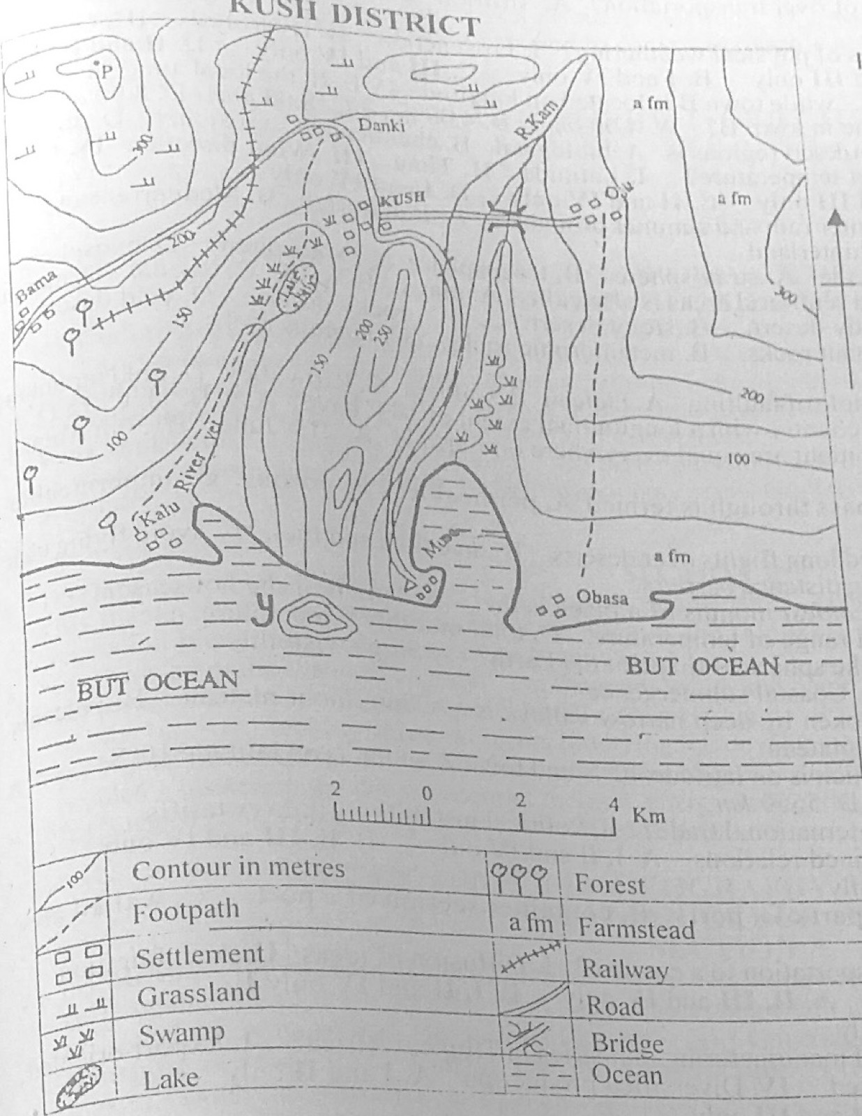
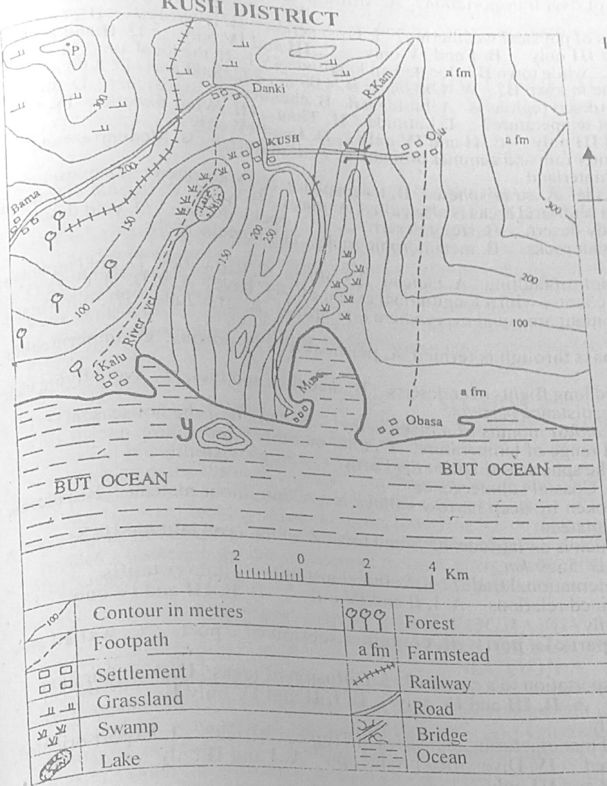
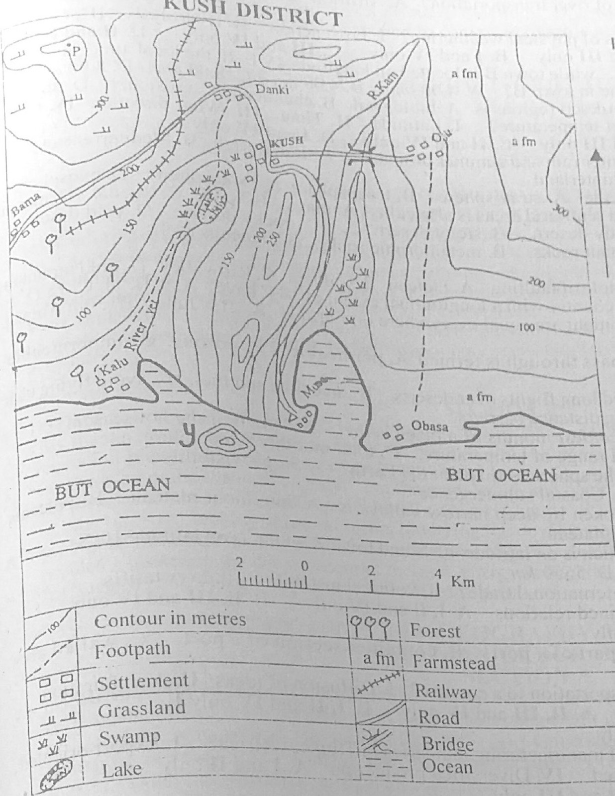
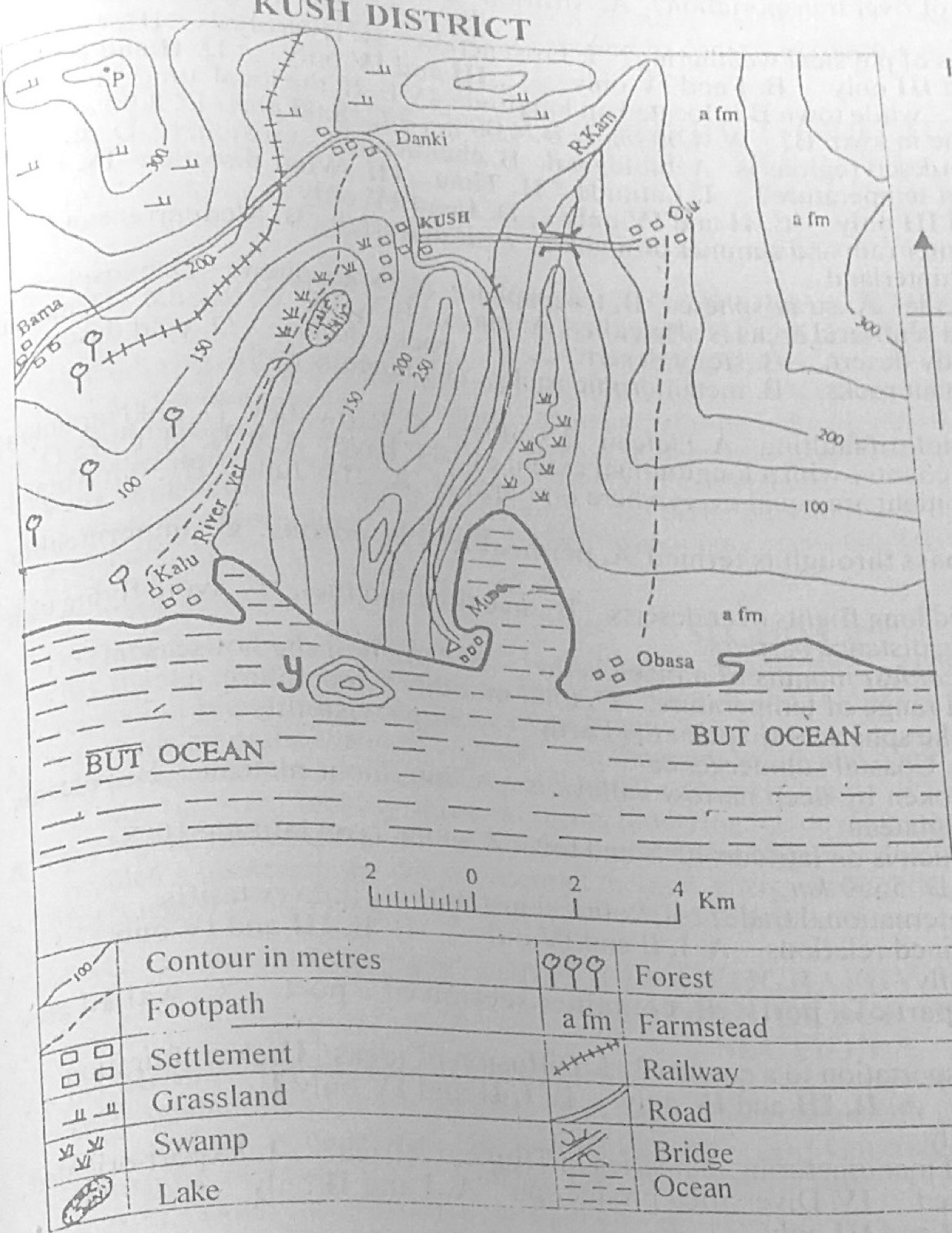
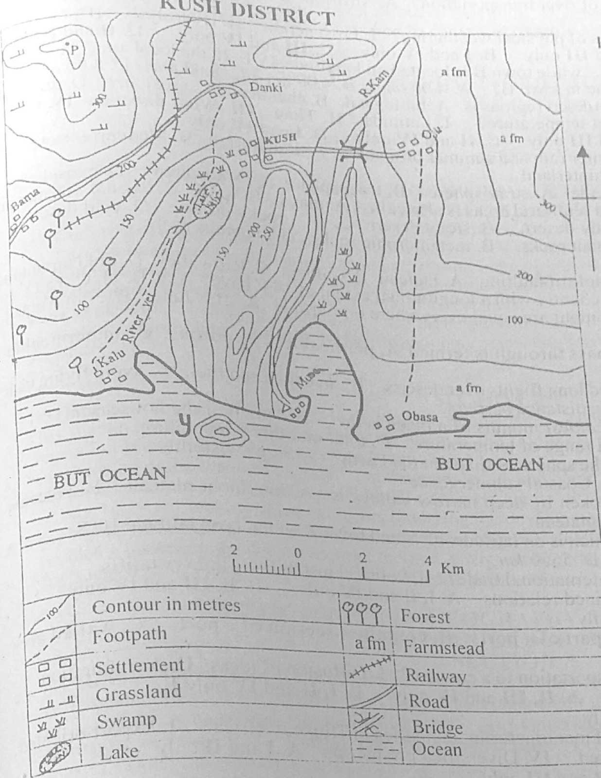
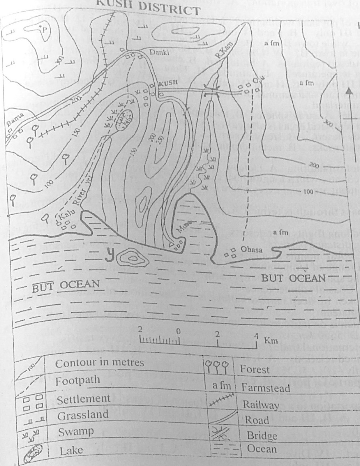
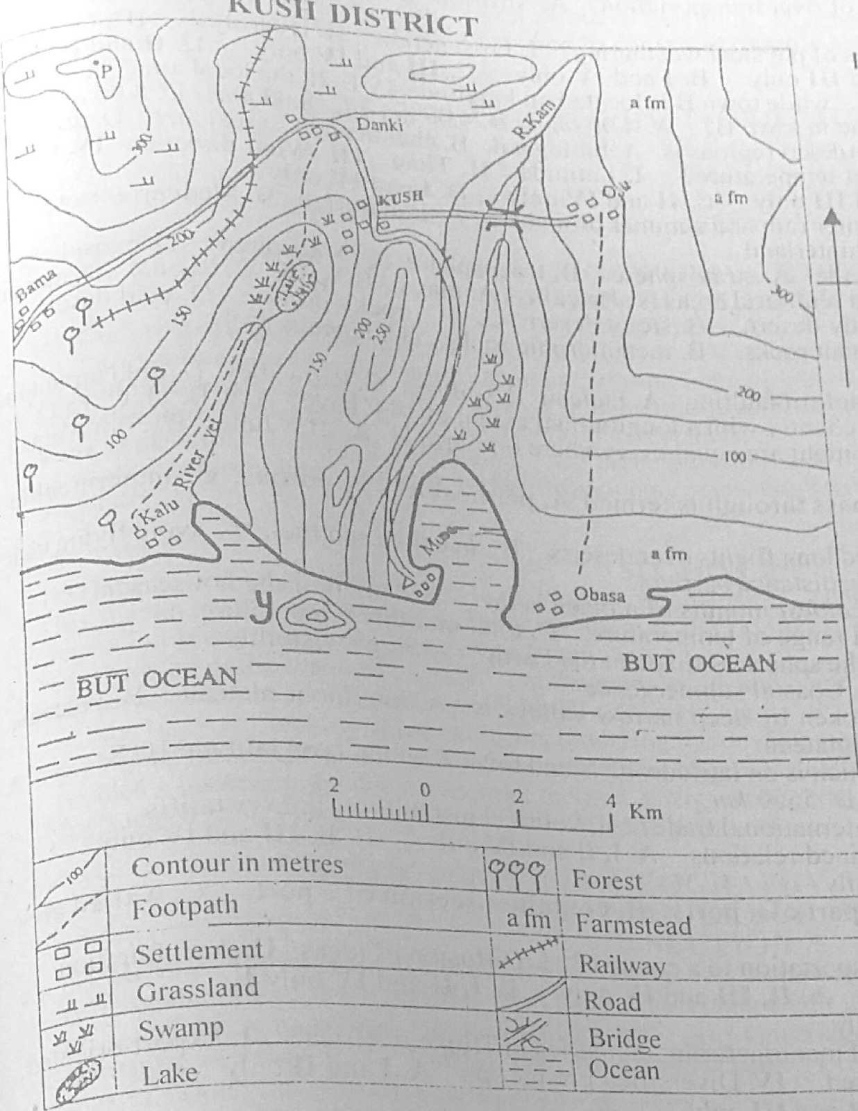
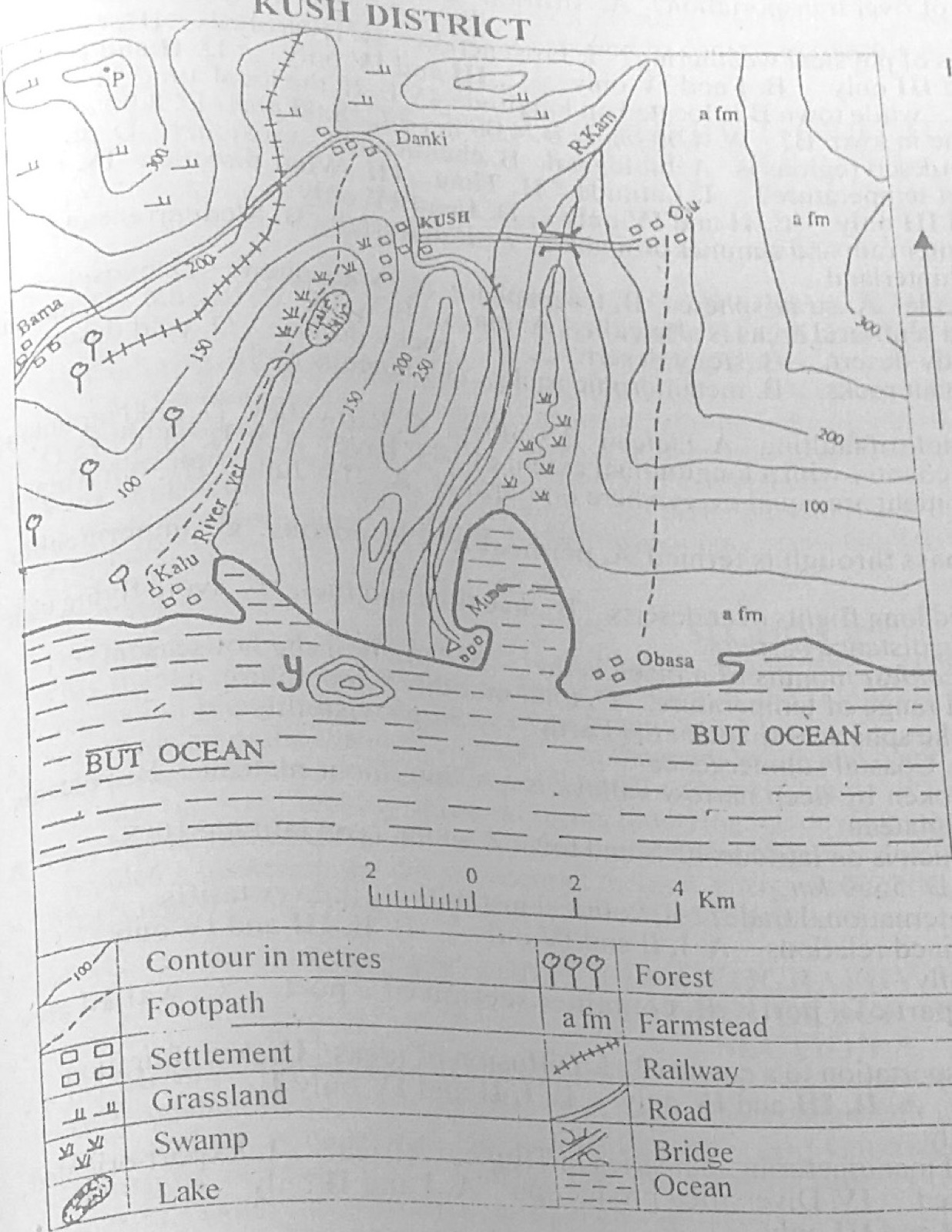
Study the map of KUSH DISTRICT to answer this question. The scale of the map is

Diagram for this question
  1. A.1 cm to ½ km.
  2. B.1 cm to 1 km.
  3. C.1 cm to 2 km.
  4. D.2 cm to 3 km.
Show the answer and explanation

Answer: B (1 cm to 1 km.)

Explanation

On the original map each kilometre division of the linear scale measures 1 cm.

Open this question

Question 2

Relief and Map Interpretation

Study the map of KUSH DISTRICT to answer this question. The height at point P is about

Diagram for this question
  1. A.275 m.
  2. B.300 m.
  3. C.375 m.
  4. D.450 m.
Show the answer and explanation

Answer: C (375 m.)

Explanation

P lies inside the closed contours above the 300 m line on the hill in the north-west, so it is a little higher, about 375 m.

Open this question

Question 4

Map Scale, Distance and Direction

Study the map of KUSH DISTRICT to answer this question. What is the approximate distance from Obasa to Oju as the crowflies?

Diagram for this question
  1. A.10 km
  2. B.18 km
  3. C.20 km
  4. D.25 km
Show the answer and explanation

Answer: A (10 km)

Explanation

Measured in a straight line and compared with the linear scale, Obasa to Oju is about 9-10 km.

Open this question

Question 5

Map Scale, Distance and Direction

Study the map of KUSH DISTRICT to answer this question. The bearing of Danki from Oju is

Diagram for this question
  1. A.90°.
  2. B.150°.
  3. C.285°.
  4. D.355°.
Show the answer and explanation

Answer: C (285°.)

Explanation

Danki lies west and a little north of Oju, so its bearing is between 270° and 315°: about 285°.

Open this question

Question 6

Relief and Map Interpretation

Study the map of KUSH DISTRICT to answer this question. The feature in the south-west of Musa is

Diagram for this question
  1. A.a cliff.
  2. B.an island.
  3. C.a cave.
  4. D.an inselberg.
Show the answer and explanation

Answer: B (an island.)

Explanation

The feature marked Y has closed contours standing in the ocean: an island.

Open this question

Question 7

Relief and Map Interpretation

Study the map of KUSH DISTRICT to answer this question. The lower section of R. Kam is showing signs of old stage because of the presence of

Diagram for this question
  1. A.spur.
  2. B.levee.
  3. C.pothole,
  4. D.meander.
Show the answer and explanation

Answer: D (meander.)

Explanation

Near the coast R. Kam winds in loops (meanders) through the swamp, a sign of old stage.

Open this question

Question 8

Relief and Map Interpretation

Study the map of KUSH DISTRICT to answer this question. Musa settlement is likely to be

Diagram for this question
  1. A.an airport.
  2. B.a fishing village.
  3. C.a confluence' town.
  4. D.a nodal town.
Show the answer and explanation

Answer: B (a fishing village.)

Explanation

Musa is on the coast of BUT OCEAN, so its people are likely to fish.

Open this question

Question 9

Relief and Map Interpretation

Study the map of KUSH DISTRICT to answer this question. A seaport can be sited in all the following settlements except

Diagram for this question
  1. A.Kalu.
  2. B.Musa.
  3. C.Obasa.
  4. D.Barna.
Show the answer and explanation

Answer: D (Barna.)

Explanation

Bama (Barna) is inland on the western edge; the others are on the coast.

Open this question

Question 10

Relief and Map Interpretation

Study the map of KUSH DISTRICT to answer this question. All the following settlements are intervisible from KUSH except

Diagram for this question
  1. A.Oju.
  2. B.Danki.
  3. C.Musa.
  4. D.Kalu.
Show the answer and explanation

Answer: D (Kalu.)

Explanation

The 150-250 m ridges between KUSH and Kalu block the view.

Open this question

Question 15

Climate

The type C of Koppen's climate is the

  1. A.warm temperate.
  2. B.tropical continental.
  3. C.humid continental.
  4. D.hot desert.
Show the answer and explanation

Answer: A (warm temperate.)

Explanation

Köppen's C climates are warm temperate (mesothermal).

Open this question

Question 16

Coastal Landforms

A fall in sea level can lead to the formation of

  1. A.mud flat.
  2. B.raised beach.
  3. C.tombolo.
  4. D.glup.
Show the answer and explanation

Answer: B (raised beach.)

Explanation

When the sea level falls, old beaches are left above the new shoreline as raised beaches.

Open this question

Question 17

Rivers and River Landforms

Which of the following is a process of river transportation?

  1. A.Attrition
  2. B.Deflation
  3. C.Abrasion
  4. D.Suspension
Show the answer and explanation

Answer: D (Suspension)

Explanation

Fine material carried along within the water is in suspension; attrition and abrasion are erosion processes.

Open this question

Question 18

Weathering, Erosion and Mass Movement

Which of the following are processes of physical weathering? I. Frost action II. Hydrolysis III. Oxidation IV. Temperature Changes

  1. A.I and III only
  2. B.I and IV only
  3. C.III and IV only
  4. D.II and III only
Show the answer and explanation

Answer: B (I and IV only)

Explanation

Frost action and temperature changes break rocks physically; hydrolysis and oxidation are chemical.

Open this question

Question 19

Latitude, Longitude and Time

Town A is located on longitude 15°E, while town B is located on longitude 45°E. If the local time in town A is 6.00 am, what will be the local time in town B?

  1. A.4.00 pm
  2. B.4.00 am
  3. C.8.00 pm
  4. D.8.00 am
Show the answer and explanation

Answer: D (8.00 am)

Explanation

B is 30° further east: 30 × 4 = 120 min = 2 hours ahead, so 6.00 am + 2 h = 8.00 am.

Open this question

Question 21

Weather

Which of the following factors affect temperature? I. Latitude II. Time III. Wind direction IV. Ocean current

  1. A.I and II only
  2. B.II and III only
  3. C.II and IV only
  4. D.I and IV only
Show the answer and explanation

Answer: D (I and IV only)

Explanation

Latitude and ocean currents are factors that control temperature; of the pairs offered only I and IV are both such factors.

Open this question

Question 22

Climate

Which climate is characterized by winter rain and summer drought?

  1. A.Equatorial
  2. B.Mediterranean
  3. C.Tropical continental
  4. D.Tropical hinterland
Show the answer and explanation

Answer: B (Mediterranean)

Explanation

The Mediterranean climate has wet winters and dry summers.

Open this question

Question 23

Structure of the Earth

Temperature decreases with height in the

  1. A.stratosphere.
  2. B.troposphere.
  3. C.ionosphere.
  4. D.exosphere.
Show the answer and explanation

Answer: B (troposphere.)

Explanation

In the troposphere temperature falls about 6.5°C per 1,000 m.

Open this question

Question 24

Wind and Desert Landforms

A temporary salt lake found in arid and semi-arid areas is also called

  1. A.playa.
  2. B.wadi.
  3. C.bajada.
  4. D.messa.
Show the answer and explanation

Answer: A (playa.)

Explanation

A playa is a temporary salt lake in a desert basin.

Open this question

Question 25

Wind and Desert Landforms

Hamada is another name for

  1. A.sandy desert.
  2. B.stony desert.
  3. C.rocky desert.
  4. D.cold desert.
Show the answer and explanation

Answer: C (rocky desert.)

Explanation

A hamada is a bare rocky desert surface swept clear of sand.

Open this question

Question 26

Rocks

Petroleum is usually found in

  1. A.resistant rocks.
  2. B.metamorphic rocks.
  3. C.igneous rocks.
  4. D.sedimentary rocks.
Show the answer and explanation

Answer: D (sedimentary rocks.)

Explanation

Oil forms from buried marine organisms in sedimentary rocks.

Open this question

Question 27

Earth Movements and Vulcanicity

One of the following features is an example of faulting.

  1. A.Plateau
  2. B.Caldera
  3. C.Rift valley
  4. D.Fold mountain
Show the answer and explanation

Answer: C (Rift valley)

Explanation

A rift valley forms when land sinks between parallel faults.

Open this question

Question 29

The Earth and Solar System

The day in which the length of day and night are equal everywhere on Earth is

  1. A.21st June.
  2. B.30th August.
  3. C.21st March.
  4. D.22nd December.
Show the answer and explanation

Answer: C (21st March.)

Explanation

21 March is an equinox.

Open this question

Question 30

Underground Water and Karst

A rock in which water cannot easily pass through is termed

  1. A.permeable.
  2. B.porous.
  3. C.impermeable.
  4. D.aquifer.
Show the answer and explanation

Answer: C (impermeable.)

Explanation

Impermeable rock does not let water pass through it.

Open this question

Question 31

Latitude, Longitude and Time

A great circle route is used to

  1. A.avoid long flights over deserts.
  2. B.save time and fuel.
  3. C.avoid flying near the north pole.
  4. D.avoid flying over long distance barriers.
Show the answer and explanation

Answer: B (save time and fuel.)

Explanation

A great circle is the shortest route, so it saves time and fuel.

Open this question

Question 33

The Earth and Solar System

Which of the following is not a proof of the spherical shape of the Earth?

  1. A.Ship's visibility
  2. B.Circular horizon
  3. C.Lunar eclipse
  4. D.Coastal submergence
Show the answer and explanation

Answer: D (Coastal submergence)

Explanation

Coastal submergence is caused by sea-level change or sinking land, not the earth's shape.

Open this question

Question 34

Earth Movements and Vulcanicity

A plateau highly eroded by rivers and broken by deep narrow valleys is

  1. A.intermont plateau.
  2. B.volcanic plateau.
  3. C.dissected plateau.
  4. D.lava plateau.
Show the answer and explanation

Answer: C (dissected plateau.)

Explanation

Rivers cut a dissected plateau into separate blocks.

Open this question

Question 35

Latitude, Longitude and Time

Calculate the distance between town Y which is on latitude 40°N and town Z which is on latitude 10°S.

  1. A.1110km
  2. B.3330 km
  3. C.4440 km
  4. D.5550 km
Show the answer and explanation

Answer: D (5550 km)

Explanation

The towns are 40 + 10 = 50° apart (opposite sides of the Equator): 50 × 111 = 5,550 km.

Open this question

Question 36

Transport, Trade and Tourism

Which of the following problems hinder international trade? I. Political instability II. Low tariffs III. Inadequate foreign exchange IV. Strained relations

  1. A.I, II and IV only
  2. B.II, III and IV only
  3. C.I, II and III only
  4. D.I, III and IV only
Show the answer and explanation

Answer: D (I, III and IV only)

Explanation

Political instability, shortage of foreign exchange and strained relations all hinder trade; low tariffs encourage it.

Open this question

Question 37

Transport, Trade and Tourism

The hinterland of a port is

  1. A.deepest part of a port.
  2. B.container section of a port.
  3. C.walled area of a port.
  4. D.area served by a port.
Show the answer and explanation

Answer: D (area served by a port.)

Explanation

The hinterland is the inland area a port serves.

Open this question

Question 38

Transport, Trade and Tourism

Which of the following are benefits of transportation to a country? I. Diffusion of ideas II. Acculturation III. Unemployment IV. Enhanced trade

  1. A.II, III and IV only
  2. B.I, II and IV only
  3. C.I, II and III only
  4. D.I, III and IV only
Show the answer and explanation

Answer: B (I, II and IV only)

Explanation

Transport spreads ideas and culture and boosts trade; it does not cause unemployment.

Open this question

Question 39

Manufacturing Industry

Which of the following are characteristics of manufacturing industries in Tropical Africa? I. Export-oriented II. Labour intensive III. Consumer-oriented IV. Diversified production

  1. A.I and II only
  2. B.II and III only
  3. C.I and IV only
  4. D.I and III only
Show the answer and explanation

Answer: B (II and III only)

Explanation

Industries in Tropical Africa are mostly labour intensive and produce consumer goods for home markets.

Open this question

Question 40

Manufacturing Industry

Which factor for location of industries explains the establishment' of cement industries near areas of limestone deposits?

  1. A.Market orientation
  2. B.Income source
  3. C.Source of raw material
  4. D.Availability of capital
Show the answer and explanation

Answer: C (Source of raw material)

Explanation

Limestone is bulky and loses weight in processing, so cement works are sited at the raw material.

Open this question

Question 43

Agriculture, Fishing and Lumbering

One characteristic feature of intensive farming is that, it is practised in urban centres where

  1. A.water supply is inadequate.
  2. B.human population is high.
  3. C.human population is low.
  4. D.demand for produce is low.
Show the answer and explanation

Answer: B (human population is high.)

Explanation

Where population is high, land is scarce and demand is large, so land is farmed intensively.

Open this question

Question 45

Manufacturing Industry

In an economy where the major problem to industrial development is the fear of failure the most important policy to revitalize the industrial sector of such an economy is

  1. A.large capital in form of loan.
  2. B.large pool of labour.
  3. C.development of innovative entrepreneurs.
  4. D.creation of industrial estates.
Show the answer and explanation

Answer: C (development of innovative entrepreneurs.)

Explanation

Fear of failure is overcome by training bold, innovative entrepreneurs willing to take risks.

Open this question

Question 46

Weather

Which of the following economic activities makes use of land and sea breeze?

  1. A.Lumbering
  2. B.Hunting
  3. C.Fishing
  4. D.Mining
Show the answer and explanation

Answer: C (Fishing)

Explanation

Fishermen in sail and paddle boats go out on the land breeze at night and return on the sea breeze by day.

Open this question

Question 47

Manufacturing Industry

An example of local craft industry is

  1. A.pottery.
  2. B.ship building.
  3. C.fish preservation.
  4. D.sand winning.
Show the answer and explanation

Answer: A (pottery.)

Explanation

Pottery is a traditional handicraft.

Open this question

Question 48

Manufacturing Industry

A dominant factor that explains the establishment of industries in some rural areas of Tropical Africa is

  1. A.development of rural areas.
  2. B.encouragement of rural-urban migration.
  3. C.reduction of crime in rural areas.
  4. D.traffic congestion in rural areas.
Show the answer and explanation

Answer: A (development of rural areas.)

Explanation

Governments site some industries in rural areas to develop them and slow migration to towns.

Open this question

Question 49

Settlement

The main difference between town and village is that,

  1. A.village has more food storage facility.
  2. B.village has more occupations.
  3. C.town performs more tertiary functions
  4. D.town has more unqualified workers.
Show the answer and explanation

Answer: C (town performs more tertiary functions)

Explanation

Towns provide many services (trade, banking, education, administration).

Open this question

Question 50

Transport, Trade and Tourism

The mode of transportation which is best used to convey perishable goods is

  1. A.air.
  2. B.rail.
  3. C.road.
  4. D.pipeline.
Show the answer and explanation

Answer: A (air.)

Explanation

Air transport is the fastest, so perishable goods reach markets before they spoil.

Open this question

Theory question 101

Manufacturing Industry

(a) Outline five reasons for industrial localization. (b) Explain five benefits of establishing manufacturing industries in rural areas.

Show the model answer
Model answer

(a) Nearness to raw materials; nearness to market; power supply; labour supply; good transport and port facilities; capital and credit facilities; government policy (industrial estates, incentives); industrial linkages and ancillary industries; shared infrastructure; industrial inertia; water supply.
(b) Employment for rural people; higher rural incomes and living standards; reduced rural-urban migration and urban congestion; development of rural infrastructure (roads, power, water); use of local raw materials and markets for farmers; growth of rural settlements into towns; even (balanced) development; skill acquisition and transfer of technology; diversification of the rural economy; revenue to government.

Explanation

Explain each benefit for rural people.

Open this question

Theory question 102

Settlement

(a) Outline four characteristics of nucleated settlement. (b) Identify four functions of cities in the world. (c) State four factors that favour the growth of settlements.

Show the model answer
Model answer

(a) Buildings are close together (compact/clustered); has a clear centre (market, palace, CBD); farmland lies outside the settlement; high population density; well connected by roads; many social amenities; close interaction among inhabitants.
(b) Administrative (Abuja, Washington); commercial and financial (Lagos, New York, London); industrial (Manchester, Detroit); port (Rotterdam, Lagos); educational (Oxford, Ibadan); religious (Mecca, Rome, Jerusalem); tourist and cultural (Paris); residential; transport nodes.
(c) Water supply; fertile soils; defence/security; nodal location (meeting of routes); mineral deposits; good harbours; administrative status; industries and jobs; good climate and relief; trade.

Explanation

Give an example city for each function.

Open this question

Theory question 103

Transport, Trade and Tourism

Write explanatory notes on the following: (a) three characteristics of ocean transportation; (b) three advantages of water transportation; (c) four ways in which poor transportation network can hinder economic development of a country.

Show the model answer
Model answer

(a) Follows definite routes (ocean trade routes); uses large ships (tankers, container ships, liners); slow; links continents and ports; carries bulky goods over long distances; affected by weather and storms; needs port facilities.
(b) Cheapest for bulky goods over long distances; large carrying capacity; natural routeways need little construction; few accidents; links countries across oceans; suitable for heavy and awkward goods.
(c) Raw materials cannot reach factories easily; farm produce rots before reaching markets; high cost of transport raises prices; rural areas remain isolated and undeveloped; discourages investors and industries; limits trade and tourism; hinders movement of labour; slows national integration and administration.

Explanation

Write each point as a short explanation.

Open this question

Theory question 104

Nigeria: Physical Setting

(a) Draw a sketch map of Nigeria. On the map, show and name: (i) the Rainforest Belt; (ii) the Sahel Savanna Belt; (iii) Ibadan. (b) Outline three characteristics of the rainforest belt. (c) In what four ways is the rainforest vegetation important to the economy of Nigeria?

Show the model answer
Model answer

(a) Map: rainforest belt across the south behind the mangrove coast (Ogun, Ondo, Edo, Delta, Imo, Cross River); Sahel savanna in the extreme north-east and north (Borno around Lake Chad, northern Sokoto, Yobe); Ibadan in the south-west on the forest-savanna margin.
(b) Tall evergreen trees (up to 45-60 m) in layers (canopies); many species mixed together; dense undergrowth where light reaches the floor; climbers (lianas) and epiphytes; hardwoods such as mahogany, iroko, obeche; buttress roots; trees shed leaves at different times so the forest is always green.
(c) Timber for building, furniture and export; raw materials for industries (plywood, paper, matches); cash crops grown there (cocoa, oil palm, rubber, kola); food, fruits and bush meat; medicinal herbs; fuel wood; employment; tourism (forest reserves); protects soil and supports rainfall.

Explanation

Describe the layered structure of the forest.

Open this question

Theory question 105

Nigeria: Physical Setting

(a) Draw an outline map of Nigeria. On the map, locate and name: (i) the interior coastland of Western Nigeria; (ii) the coastal plain; (iii) the Niger delta; (iv) Port Harcourt. (b) Highlight three benefits derived from coastlands of Nigeria. (c) Identify three problems hindering the development of seaports in Nigeria.

Show the model answer
Model answer

(a) Map: interior coastland (lowlands) of Western Nigeria behind the coast in Ogun, Ondo and Lagos hinterland; coastal plain (lagoons and sand bars) along the coast from Lagos eastward; Niger Delta with its many distributaries between the Benin River and the Cross River (Bayelsa, Rivers, Delta); Port Harcourt on the Bonny River in the eastern delta.
(b) Petroleum and natural gas; fishing grounds; sites for seaports and trade; lumbering and timber; tourism (beaches); land for crops such as oil palm, rubber, coconut; salt and sand for building; employment.
(c) Sand bars and spits across river mouths; constant silting of channels requiring dredging; lagoons and swamps; lack of natural deep harbours (straight coast); coastal erosion and strong surf; water weeds; inadequate capital and poor management; poor roads to the hinterland.

Explanation

Place Port Harcourt in the eastern delta.

Open this question

Theory question 106

Mining and Energy

(a) Name two sources of: (i) thermal energy in Nigeria; (ii) renewable energy in Nigeria. (b) Identify four problems hindering the development of thermal energy in Nigeria. (c) Suggest solutions to the problems identified in 6(b).

Show the model answer
Model answer

(a)(i) Coal; natural gas; petroleum (crude oil, diesel); fuel wood/charcoal.
(ii) Solar (sun); wind; water (HEP); biomass/biogas; waves and tides.
(b) Inadequate capital and high cost of power stations; shortage of skilled manpower; vandalism of gas pipelines and sabotage; irregular gas supply; high cost of spare parts and poor maintenance; low level of technology; poor management and corruption; competition with HEP; insecurity.
(c) Provide adequate funding and encourage private investment; train and retrain technicians; protect pipelines with security patrols and punish vandals; ensure regular gas supply (gas pipelines, ending flaring); local fabrication of spare parts and regular maintenance; transfer of technology; good management and monitoring; consistent government policy.

Explanation

Match each solution to a problem.

Open this question

Theory question 302

Statistical Maps and Diagrams

The countries listed in Table X below contributed money as indicated for a joint project in the year 2017. Use the data in the table to answer the questions that follow.
Country A: $35,000
Country B: $60,000
Country C: $45,000
Country D: $80,000
Country E: $30,000
(a) Represent the data in Table X on a vertical divergent bar graph. (b) State one use of divergent bar graph.

Show the model answer
Model answer

(a) Average contribution = (35,000 + 60,000 + 45,000 + 80,000 + 30,000) ÷ 5 = 250,000 ÷ 5 = $50,000. Deviations from the average: A −15,000; B +10,000; C −5,000; D +30,000; E −20,000. Draw a horizontal base line for the average ($50,000); choose a vertical scale (e.g. 1 cm = $5,000); draw bars upward for B and D and downward for A, C and E to the correct lengths; equal widths and gaps; label countries, axis and title, and shade positive and negative bars differently with a key.
(b) Shows values above and below an average or zero (gains and losses, surplus and deficit, e.g. balance of trade, temperature anomalies, population change).

Explanation

Work out the average first.

Open this question

Theory question 303

Climate

(a) List five factors that affect climate. (b) Highlight five characteristics of Equatorial climate.

Show the model answer
Model answer

(a) Latitude; altitude; distance from the sea (continentality); ocean currents; prevailing winds and pressure belts; relief (slope and aspect); natural vegetation; cloud cover; human activities (urbanisation, industry).
(b) High temperatures all year (about 27°C); very small annual range (2-3°C); heavy rainfall (over 2,000 mm) throughout the year; double maxima of rainfall (near the equinoxes); convectional rain with afternoon thunderstorms; high relative humidity (over 80%); cloudy skies; small diurnal range; calm air (doldrums).

Explanation

Give figures for temperature and rainfall.

Open this question

Theory question 304

Weathering, Erosion and Mass Movement

(a) Define weathering. (b) Identify three factors that affect weathering. (c) Describe the processes of exfoliation.

Show the model answer
Model answer

(a) Weathering is the breakdown or decay of rocks in their original position (in situ) by physical, chemical or biological processes, without the material being moved.
(b) Climate (temperature and rainfall); rock type and mineral composition; rock structure (joints, bedding planes); relief/slope; vegetation and living organisms; human activities; time.
(c) Exfoliation (onion weathering): in hot deserts rocks are heated strongly by day and cooled quickly at night; rocks are poor conductors, so the outer layer expands and contracts more than the inside; repeated stress creates cracks parallel to the surface; the outer shells peel off like the layers of an onion; moisture from dew can speed it up; it leaves rounded rock masses (exfoliation domes).

Explanation

Stress repeated heating and cooling.

Open this question

Theory question 306

Rivers and River Landforms

(a) List five landforms found in the upper course of a river. (b) Highlight three differences and two similarities between an alluvial fan and a delta.

Show the model answer
Model answer

(a) V-shaped valley; gorge; waterfall; rapids; potholes; interlocking spurs; plunge pool; river capture features.
(b) Differences: an alluvial fan forms on land at the foot of a highland where a stream leaves a steep valley, a delta forms where a river enters a sea or lake; alluvial fans contain coarse material (gravel, boulders), deltas mostly fine silt and clay; alluvial fans are common in dry areas and are often dry, deltas have water most of the time; deltas are larger, with many distributaries; fans slope more steeply.
Similarities: both are depositional features formed by rivers; both are fan- or triangle-shaped; both form where the river suddenly loses speed; both are made of alluvium; both have streams dividing into several channels.

Explanation

Three differences and two similarities exactly.

Open this question

Theory question 307

Climate

(a) Define climate. (b) Draw the globe and show the three climatic belts of the Greek System of classification. (c) List three areas of hot desert climate. (d) Outline three characteristics' of hot deserts.

Show the model answer
Model answer

(a) Climate is the average weather conditions of a place over a long period, usually about 35 years.
(b) Globe showing the torrid zone between the Tropics of Cancer (23½°N) and Capricorn (23½°S); the north and south temperate zones between the tropics and the Arctic/Antarctic Circles (66½°); the north and south frigid zones from the circles to the poles.
(c) Sahara; Kalahari and Namib; Arabian Desert; Thar Desert; Great Australian Desert; Atacama; Sonoran/Mojave.
(d) Very low and unreliable rainfall (under 250 mm); very high day temperatures and cold nights (large diurnal range); low humidity and clear skies; strong winds and dust storms; high evaporation; sparse xerophytic vegetation.

Explanation

Mark latitudes on the globe.

Open this question

Theory question 308

Environmental Hazards and Conservation

(a) Define atmospheric pollution. (b) List four major sources of air pollutants. (c) Highlight four effects of atmospheric pollution.

Show the model answer
Model answer

(a) Atmospheric pollution is the release into the air of harmful substances (gases, smoke, dust, chemicals) in amounts that damage people, animals, plants or property.
(b) Industrial smoke and fumes; vehicle exhaust; gas flaring; burning of refuse and bush burning; generators; volcanic eruptions; dust from mining and quarrying; aerosols and refrigerants (CFCs).
(c) Respiratory diseases (asthma, bronchitis); acid rain damaging buildings, forests and lakes; depletion of the ozone layer; global warming and climate change; smog and reduced visibility; damage to crops and vegetation; unpleasant smells.
Explanation

Four effects, each in a phrase or sentence.

Open this question