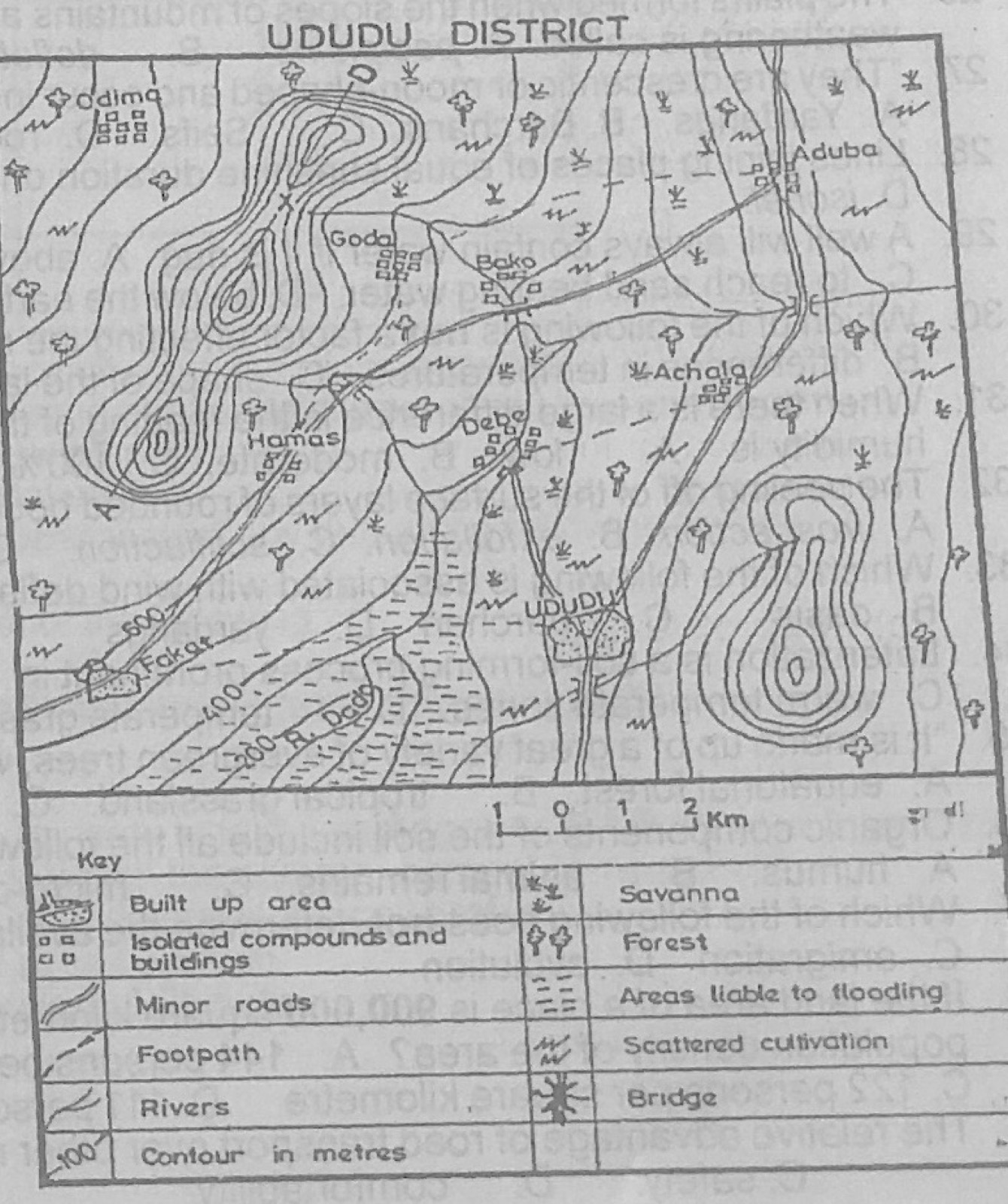
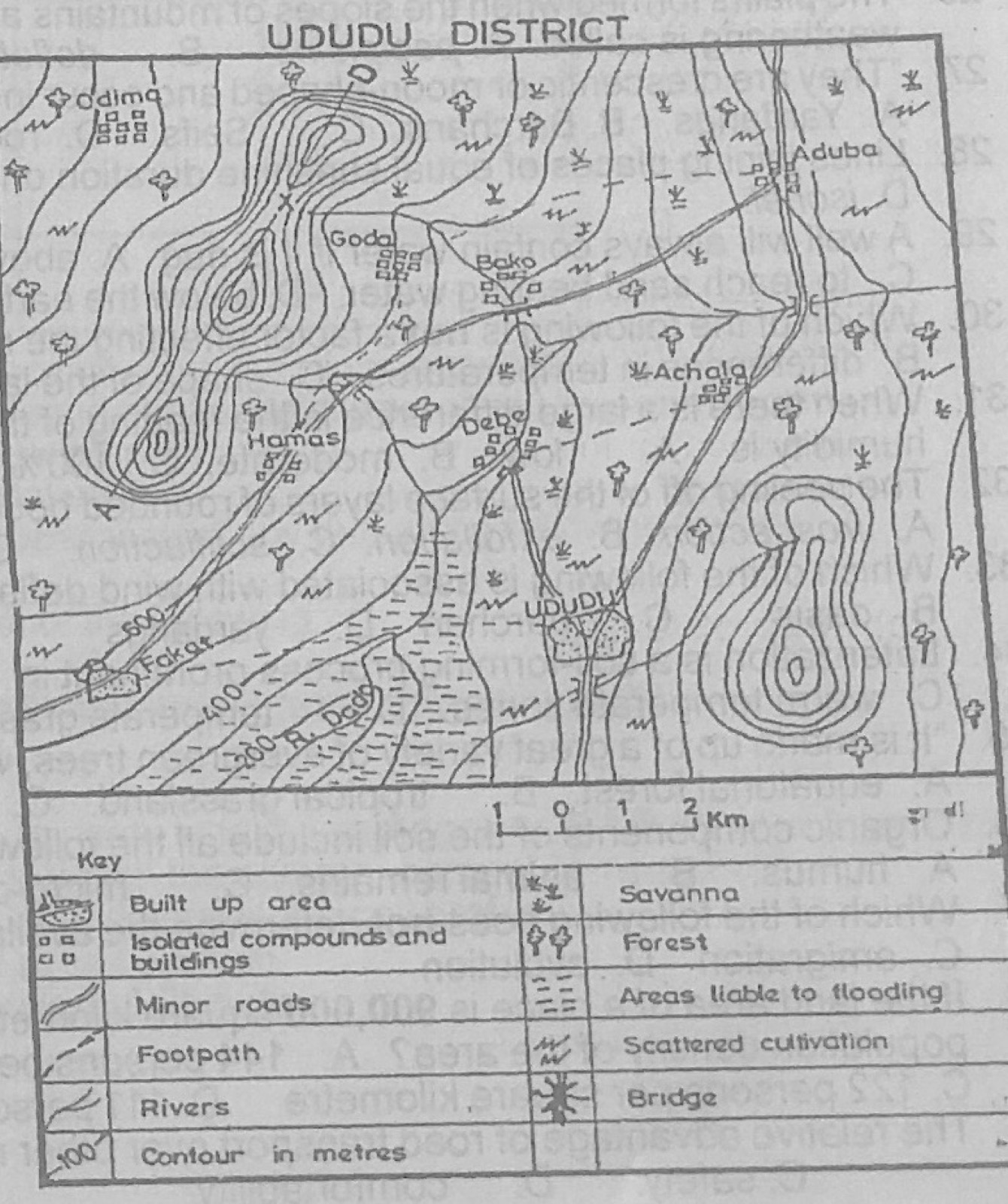
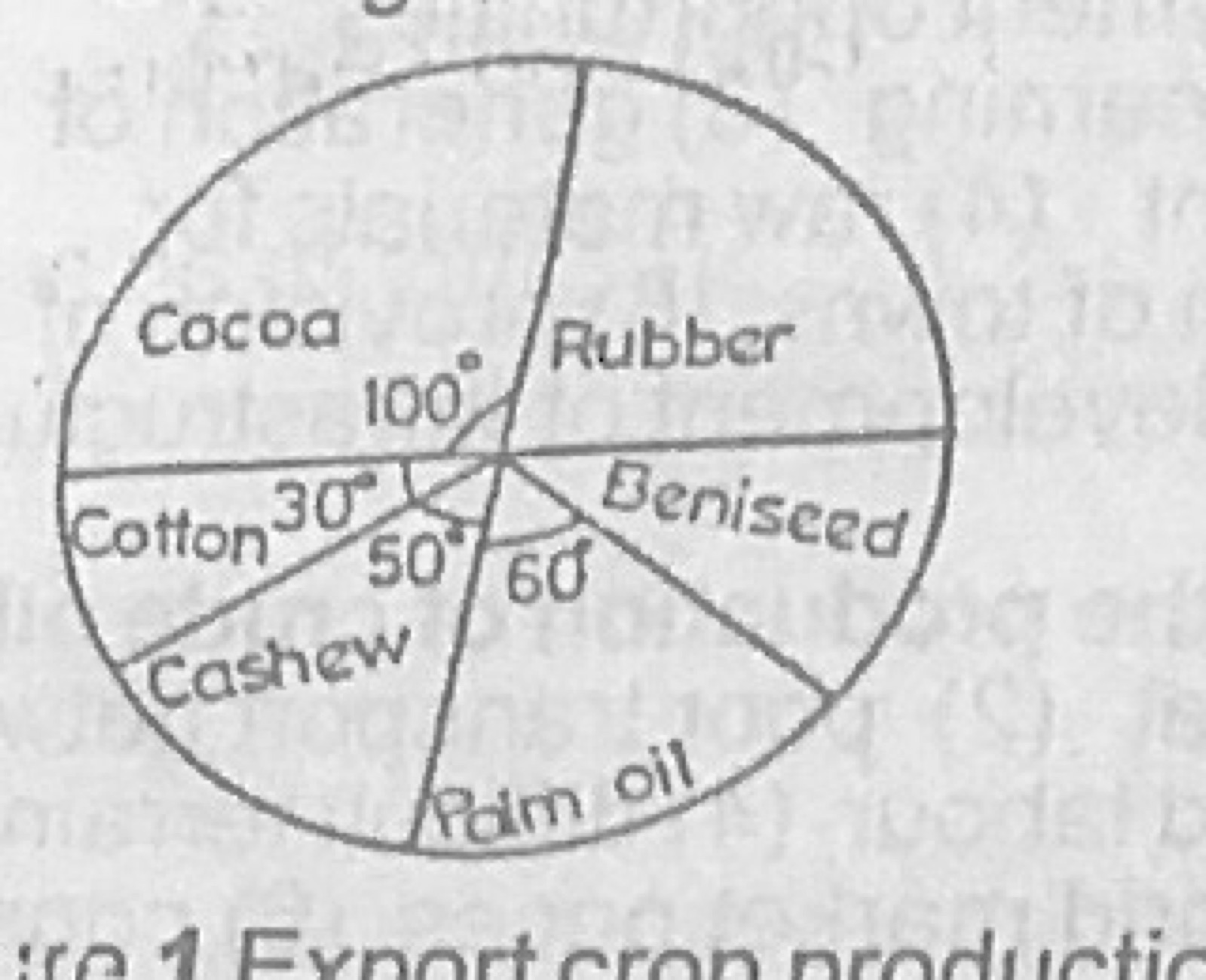
Use Figure 1 (pie chart: Export crop production of Nigeria, 1990, in metric tonnes; total output was 400,000 metric tonnes; sector angles: Cocoa 100°, Cotton 30°, Cashew 50°, Palm oil 60°, Rubber and Beniseed unlabelled) to answer this question. What is the total output of cocoa?
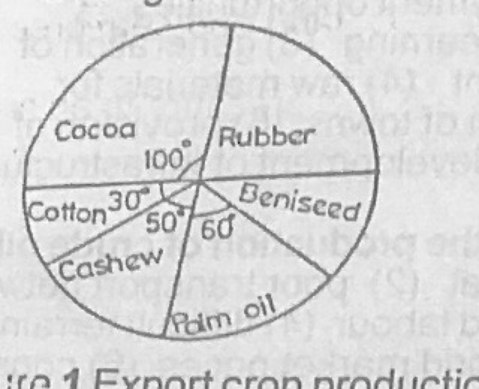
Use Figure 1 (pie chart: Export crop production of Nigeria, 1990, in metric tonnes; total output was 400,000 metric tonnes; sector angles: Cocoa 100°, Cotton 30°, Cashew 50°, Palm oil 60°, Rubber and Beniseed unlabelled) to answer this question. The percentage production of palm oil is
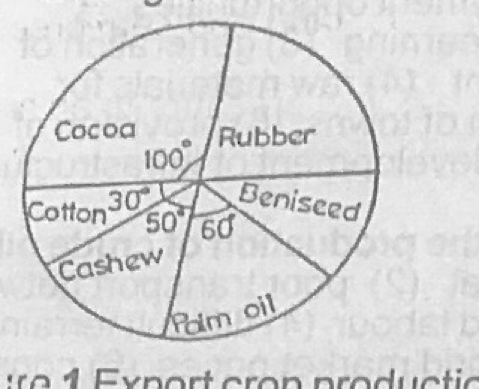
Use Figure 1 (pie chart: Export crop production of Nigeria, 1990, in metric tonnes; total output was 400,000 metric tonnes; sector angles: Cocoa 100°, Cotton 30°, Cashew 50°, Palm oil 60°, Rubber and Beniseed unlabelled) to answer this question. The total output of cashew and cotton is
Which of the following is not a factor affecting the movement of ocean currents?
A.the planetary winds
B.differences in temperatures
C.shape of the landmass
D.differences in the rate of evaporation
Show the answer and explanation
Answer: D (differences in the rate of evaporation)
Explanation
Currents are driven mainly by prevailing winds, temperature (density) differences and the earth's rotation, and are steered by coastlines; evaporation is the least direct of these.
(a) Outline four factors which promote international trade between your country and the outside world. (b) Explain three problems involved in the trade between your country and other West African countries. (c) Suggest three solutions to the problems explained in 1(b) above.
Show the model answer
Model answer
(a) Differences in natural resources and climate (Nigeria sells oil and cocoa, buys machinery); differences in technology; demand for foreign goods; good transport and communication links; favourable government policy and trade agreements; membership of economic groups (ECOWAS, Commonwealth); need for foreign exchange; political stability. (b) Similar products so little to exchange; different currencies and exchange problems; poor transport links between countries; tariffs, border closures and smuggling; language differences; political disputes; ties to former colonial powers; low level of industrial production. (c) Diversify and specialise production; common currency or easier exchange; build international roads and railways; remove tariffs (ECOWAS trade liberalisation); improve ports and border procedures; promote political stability and regional integration.
Explanation
Make the solutions in (c) answer the problems in (b).
(a) In what five ways has railway transport contributed to economic development in Tropical Africa? (b) Suggest five ways of improving the development of railway transport in Tropical Africa.
Show the model answer
Model answer
(a) Carries bulky goods (minerals, crops) cheaply over long distances; links interior producing areas to ports for export; opens up new areas for farming and mining; growth of towns along lines (e.g. Kaduna, Jos); employment; revenue to government; movement of people; national integration and spread of ideas. (b) Extend and link the networks; convert to standard gauge and double tracks; provide adequate capital; modernise locomotives and coaches; regular maintenance; training of staff and better management; privatisation or partnerships; international rail links.
(a) Highlight three human and three physical factors which may favour a rapid growth of population. (b) State four problems that may arise from rapid population growth.
Show the model answer
Model answer
(a) Human: improved medical care lowering death rates; improved food supply and agriculture; early marriage and polygamy; religious and cultural beliefs against birth control; immigration; industrialisation and social amenities. Physical: favourable climate; fertile soils; availability of water; gentle relief; presence of minerals. (b) Food shortage and malnutrition; unemployment; overcrowding and housing shortage; pressure on schools, hospitals and other services; high dependency ratio; crime and social vices; environmental degradation; inflation.
Explanation
Keep human and physical factors in separate lists.
For candidates in Nigeria: (a) Draw an outline map of Nigeria. On the map, show and name: (i) two international airports (ii) the railway line between Lagos and Minna (iii) one major inland waterway (iv) one seaport and one riverport. (b) In what four ways is road transport of economic importance to Nigeria? (c) Highlight two problems of road transportation in Nigeria.
Show the model answer
Model answer
(a) Airports: Murtala Muhammed (Lagos), Nnamdi Azikiwe (Abuja), Mallam Aminu Kano (Kano), Port Harcourt; railway Lagos-Abeokuta-Ibadan-Oshogbo-Ilorin-Jebba-Minna; inland waterway: River Niger (or Benue); seaport: Lagos (Apapa), Port Harcourt, Warri, Calabar; river port: Onitsha, Lokoja, Baro, Makurdi. (b) Moves goods and people door to door; links rural areas to markets; aids internal trade; feeds other transport (ports, rail); provides employment; opens up the interior; spreads ideas and innovation. (c) Poor condition and maintenance of roads; high cost of vehicles, spare parts and fuel; traffic congestion and accidents; armed robbery and checkpoints; seasonal roads impassable in the rainy season.
Explanation
Show the railway as a line with cross-ticks and name each item on the map.
For candidates in Nigeria: (a) Draw an outline map of Nigeria. On the map, show and name: (i) one area noted for the mining of any three of the following: crude oil; limestone; columbite; iron ore; (ii) one major town in any three of the areas shown in 5(a)(i) above. (b) Outline five ways in which crude oil contributes to the economic development of Nigeria.
Show the model answer
Model answer
(a) Crude oil: Niger Delta (Port Harcourt, Warri); limestone: Ewekoro (Abeokuta), Nkalagu (Enugu), Sokoto, Ukpilla (Okene), Calabar; columbite: Jos Plateau (Jos); iron ore: Itakpe (Okene), Agbaja (Lokoja). (b) Main source of foreign exchange; main source of government revenue; employment; raw materials for petrochemical and fertilizer industries; fuel and energy for transport, industry and power; growth of towns and infrastructure; attracts foreign investment; training of manpower.
For candidates in Nigeria: (a) Draw an outline map of Nigeria. On the map, locate: (i) one area each for the production of cocoa, palm produce, groundnut and cotton. (ii) three towns in any three of the areas. (b) Highlight three major problems of agriculture in Nigeria. (c) Suggest solutions to the problems highlighted in 6(b) above.
Show the model answer
Model answer
(a) Cocoa: south-west (Ibadan, Ondo, Akure, Ile-Ife); palm produce: south-east and mid-west (Owerri, Umuahia, Benin City, Calabar); groundnut: north (Kano, Katsina, Zaria); cotton: north (Zaria, Funtua, Gusau, Kaduna). (b) Poor and unreliable rainfall, drought and floods; pests and diseases; poor soils and erosion; lack of capital and credit; use of crude tools; poor storage and transport; land tenure problems; low prices and poor marketing; rural-urban migration of youths. (c) Irrigation and drought-resistant crops; pesticides and improved seeds; fertilizers and soil conservation; loans and agricultural banks; mechanisation; storage facilities and good roads; land reform; guaranteed prices; incentives for young farmers and extension services.
(a)(i) Name two areas of copper mining in Zambia (ii) Describe one method of copper mining in Zambia. (b) Highlight four contributions of copper mining to the economic development of Zambia. (c) What three problems face the mining of copper in Zambia?
Show the model answer
Model answer
(a)(i) Copperbelt towns: Kitwe (Nkana), Ndola, Mufulira, Chingola (Nchanga), Luanshya (Roan Antelope), Chililabombwe. (ii) Open-cast: overburden removed by explosives and excavators, ore dug in terraces and carried by trucks (Nchanga). Underground (shaft): vertical shafts sunk to the ore body, horizontal tunnels driven, ore blasted and hoisted; ore crushed, ground, concentrated by flotation and smelted into copper. (b) Main source of foreign exchange; government revenue; employment; growth of towns and infrastructure (roads, railways like TAZARA); raw materials and growth of related industries; power development (Kariba, Kafue); manpower training. (c) Landlocked country, long distance to ports and high transport costs; fluctuating world copper prices; shortage of capital and skilled labour; exhaustion of deposits and rising costs of deeper mining; flooding of mines and pollution; power shortages.
Explanation
Mention Zambia's landlocked position among the problems.
(a) Draw a sketch map of West Africa. On the map, locate and name: (i) two ECOWAS countries along the coast (ii) two ECOWAS countries in the interior (iii) the capitals of any three of the countries in 8(a)(i) and (ii) above. (b) Highlight three problems facing the Economic Community of West African States. (c) Suggest possible solutions to the problems in 8(b) above.
Show the model answer
Model answer
(a) Coastal: Nigeria (Abuja), Ghana (Accra), Senegal (Dakar), Côte d'Ivoire (Yamoussoukro/Abidjan), Liberia (Monrovia), Sierra Leone (Freetown); interior: Mali (Bamako), Niger (Niamey), Burkina Faso (Ouagadougou). (b) Different currencies; language barriers (English, French, Portuguese); political instability and conflicts; similar products limiting trade; poor transport links; members' loyalty to other blocs and former colonial powers; non-payment of dues; smuggling and border restrictions. (c) Common currency; teaching of common languages; peace-keeping (ECOMOG) and good governance; diversify production; build regional roads and railways; members to pay dues; harmonise policies and remove trade barriers.
Explanation
Use a key to separate coastal and interior countries.
(a) Draw a sketch map of Africa. On the map, locate and name two areas important for lumbering. (b) Outline four factors that promote lumbering in Africa. (c) Highlight three benefits of lumbering in Africa.
Show the model answer
Model answer
(a) Congo Basin (DR Congo, Congo, Gabon, Cameroon); Guinea coast forests (Côte d'Ivoire, Ghana, southern Nigeria); East African highlands forests. (b) Large areas of tropical forest with valuable hardwoods (mahogany, obeche, iroko, sapele, ebony); demand in Europe and local markets; rivers for floating logs; cheap labour; modern machinery (power saws, tractors); roads and railways to ports; government support and concessions; capital investment. (c) Foreign exchange from timber exports; employment; raw materials for sawmills, plywood, furniture, paper industries; revenue to government; opening up of forest areas by roads; fuelwood and building materials.
Explanation
Name hardwood species and the rivers/ports used to export them.
The table below shows the direct premium income of non-life insurance business for Nigeria in a particular year. Use the data to answer the questions that follow: Fire: value ₦24,532,000, percentage 12.1 Accident: ₦13,770,000, 6.8 Motor: ₦94,442,000, ? Marine: ₦49,536,000, 24.5 Miscellaneous: ₦20,040,000, ? Total: ₦202,320,000, 100 (a) Calculate the missing percentages for motor and miscellaneous premium incomes. (b)(i) Construct a percentage bar graph to illustrate the above statistics. (ii) State two disadvantages of a percentage bar graph. (c) Suggest an alternative method of representing the statistics.
Show the model answer
Model answer
(a) Motor = 94,442,000 ÷ 202,320,000 × 100 = 46.7%; Miscellaneous = 20,040,000 ÷ 202,320,000 × 100 = 9.9% (check: 12.1 + 6.8 + 46.7 + 24.5 + 9.9 = 100). (b)(i) One bar of suitable length (e.g. 10 cm = 100%) divided into segments: fire 1.21 cm, accident 0.68 cm, motor 4.67 cm, marine 2.45 cm, miscellaneous 0.99 cm; each shaded differently with a key, title and scale. (ii) Actual values cannot be read from it; percentages must first be calculated, which takes time and can introduce errors; very small parts are hard to show; difficult to compare with other years with different totals. (c) Pie chart (or divided circle), simple bar graph, or divided rectangle.
Explanation
Show the formula and working, and make sure the percentages add to 100.
With the aid of diagrams, describe the formation and appearance of any two of the following features: (i) Stack (ii) Blow Hole (iii) Sand Bar
Show the model answer
Model answer
(i) Stack: waves attack a headland and erode joints into caves (hydraulic action, abrasion); caves on both sides join to form an arch; the arch roof collapses, leaving an isolated pillar of rock standing in the sea; appears as a steep-sided column cut off from the cliff (e.g. Old Man of Hoy). (ii) Blow hole: waves enlarge a sea cave along a joint; compressed air and water force their way up through a weakness in the cave roof to the cliff top; a vertical shaft forms through which spray is blown out at high tide. (iii) Sand bar: longshore drift carries sand along the coast; where the coast changes direction or across a bay mouth the sand is deposited; it grows into a ridge of sand parallel to or across the coast, often enclosing a lagoon (e.g. Lagos lagoon bar); low, long and narrow.
Explanation
Draw labelled diagrams showing the stages of formation.
With the aid of diagrams, describe the formation of each of the following: (a) Orographic rainfall (b) Convectional rainfall
Show the model answer
Model answer
(a) Orographic (relief) rainfall: moist wind from the sea meets a mountain barrier and is forced to rise; it cools adiabatically, reaches dew point and condenses to form clouds; heavy rain falls on the windward side; air descends on the leeward side, warms and gives little rain (rain shadow), e.g. Cameroon Highlands, Jos Plateau. (b) Convectional rainfall: intense heating of the ground warms the air above; the warm moist air expands and rises in strong convection currents; it cools and condenses to form towering cumulonimbus clouds; heavy afternoon showers with thunder and lightning follow; common in equatorial regions.
Explanation
Label wind direction, rising air, condensation level and rain on each diagram.
(a) What is environmental hazard? (b) Name five examples of environmental hazards. (c) Explain any three effects of environmental pollution.
Show the model answer
Model answer
(a) An environmental hazard is any natural or human-induced event or condition that poses a danger to people's lives, property and the environment. (b) Flooding; drought; desertification; soil erosion; earthquakes; volcanic eruptions; landslides; pollution; deforestation; bush fires; storms and hurricanes. (c) Air pollution causes breathing diseases, acid rain and global warming; water pollution kills fish and spreads diseases like cholera; land pollution reduces soil fertility and crop yields; noise pollution causes deafness and stress; oil spills destroy farmland and fishing grounds.
Explanation
Explain how each type of pollution harms people or living things.
(a) Highlight four effects of the revolution of the earth. (b) A boxing tournament is scheduled to start at 8.00 p.m. local time in Los Angeles, 75°W. At what time should boxing fans in Nigeria, 15°E, switch on their televisions to watch the commencement of the match?
Show the model answer
Model answer
(a) Changes of seasons; varying lengths of day and night through the year; changes in the altitude of the midday sun; the overhead sun's apparent movement between the tropics; perihelion and aphelion; determines the length of the year (365¼ days) and leap year. (b) Difference in longitude = 75° + 15° = 90°; time difference = 90 × 4 minutes = 6 hours; Nigeria is east so ahead: 8.00 p.m. + 6 h = 2.00 a.m. the next day.
(a) Outline four components of soil. (b) Describe, using a diagram, the soil profile. (c) Highlight any three farming practices that can lead to soil erosion.
Show the model answer
Model answer
(a) Mineral matter (rock particles); organic matter (humus); water; air; living organisms (micro-organisms, worms). (b) Diagram of horizons: O/litter layer of dead leaves; A horizon (topsoil) dark, rich in humus, zone of leaching (eluviation); B horizon (subsoil) zone of accumulation (illuviation) of leached minerals and clay, lighter in colour; C horizon of weathered parent rock; D/R horizon of unweathered bedrock. (c) Bush burning; overgrazing; continuous cropping without fallow; ploughing up and down slopes; clearing all vegetation (deforestation); shifting cultivation with short fallow.
Explanation
Label each horizon with its letter and a short description.
(a) Highlight characteristic features of the Tropical Continental Climate. (b) Describe the vegetation of the Savanna region.
Show the model answer
Model answer
(a) Distinct wet season (summer) and dry season (winter); rainfall 500-1,500 mm decreasing away from the equator; high temperatures (21-32°C) with a larger annual range (5-10°C) than equatorial areas; hottest just before the rains; dry harmattan winds in the dry season; low humidity in the dry season; e.g. Kano, Khartoum. (b) Tall grasses (elephant grass up to 3 m in the Guinea savanna, shorter in the Sudan and Sahel); scattered deciduous trees (baobab, shea butter, acacia, locust bean); trees with thick bark, long roots and small leaves; grasses dry up and are burnt in the dry season and sprout with rain; gallery forests along rivers; vegetation thins northward.
Explanation
Describe rainfall, temperature, seasons and winds for the climate.